Monday, January 12, 2015

Flying A Light Aircraft Over Northern Arizona's Great Landscapes

All photographs on this posting are copyright Wayne Ranney and Ted Grussing


On January 8, I was privileged to fly with Ted Grussing in his light aircraft over the canyons and volcanic fields of northern Arizona. To say that Ted is generous with his time aloft would not convey an idea of the numerous times he has taken anyone up to see the earth from this fantastic perspective. Even those who never ask to go - like me. I never asked Ted to take me me up in his motorized glider plane. He just said to me one day, "I'd like to take you up one day." So in the spirit that I've lived my life in, namely how I've never been able to say "No" to adventure, I said, "Sure"!

On a fantastic "blue-bird" day, I drove down the winding switchbacks through snow-covered Oak Creek Canyon to find Ted pulling his craft out of the mesh fabric hanger it resides in.

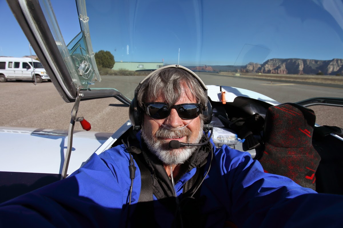
Here is a picture of Ted next to his beauty. If you are not aware of Ted or his stunning photographs, you can check them out on his web site here. His work has appeared Sojourns and Arizona Highways, magazines, as well as other well-known journals.

I've always enjoyed flying with anyone no matter what the craft or conveyance. One time on a whim in 1976, I said yes to jumping out of an airplane! It's true I do not always think things out thoroughly. My first inclination is always to say, "YES!" only to find out later that some things are just better left alone. Don't get me wrong - I did not have such thoughts before saying yes to Ted. But when I saw how small the cockpit was, I realized that this was no Cessna flight.

Outfitted with supplemental oxygen, since we were going over 10,000 feet. Heck, I never had supplemental oxygen on Kilimanjaro last summer at 19,000 feet. This was cool.

Taxiing for take-off!

We took-off on Sedona 23 and headed northeast over Oak Creek Canyon. The San Francisco Peaks are in the upper right and the canyon follows the Oak Creek Canyon fault south from their western flank. You can easily see that the west side (left) of the canyon contains colorful, upper Paleozoic strata, more well-known from the Grand Canyon to the north of here. But the east side exposes only basalt lava, suggesting that those rocks were eroded away before the lava flows filled an ancestral valley here. Also, the burn from the Slide Fire can be seen on top of the triangular peninsula on top of the sedimentary rocks. Ted says that he gets much additional lift when gliding over burned areas.

Speaking of burns, there was this a prescribed burn flaring south of Flagstaff. Ted has been outspoken in his opposition to the fires, purposely set to burn slash from forest thinning projects. However, the price to pay is in human health from the particulates and the tainting of otherwise pure mountain air. Ted believes the health risks warrant not burning the piles and suggests they could chip the wood instead. The forest does need thinning but he made me consider if burning is the only option there is to deal with the waste. Perhaps like most things these days, burning simply is the cheapest and easiest thing to do. But, is cheapest and easiest the most civilized thing to do?

There's Flagstaff! In all its clear brilliance on a clear winter day (with the smoke blowing southeast away from town). Note I-40 trending away from the bottom toward New Mexico. Mt. Elden can be seen as the curiously mountain with an "apron" beyond the city.

Here is a close-up of Mt,. Elden with its familiar "apron," actually lobes of dacite lava that formed when very viscous lava erupted from the vent on top. As the lava was extruded it flowed downslope but at an incredibly slow rate due to its viscosity. Tress today have a harder time growing on the solid dacite rock more than the rubble around it and that outlines the distal ends of these lava lobes. All of this occurred around 500,000 years ago in the heart of the Pleistocene epoch (the Ice Age).

Tipping the wings for an unforgettable view of the southwest side of Mt. Elden and its lava lobes.

Flying past the San Francisco Peaks for other volcanic treasures.

Northeast of Flagstaff are the cinder hills, where Apollo astronauts trained for their mission to the moon. Geologists had suspected that the moon would be volcanic and this was a good analog landscape.

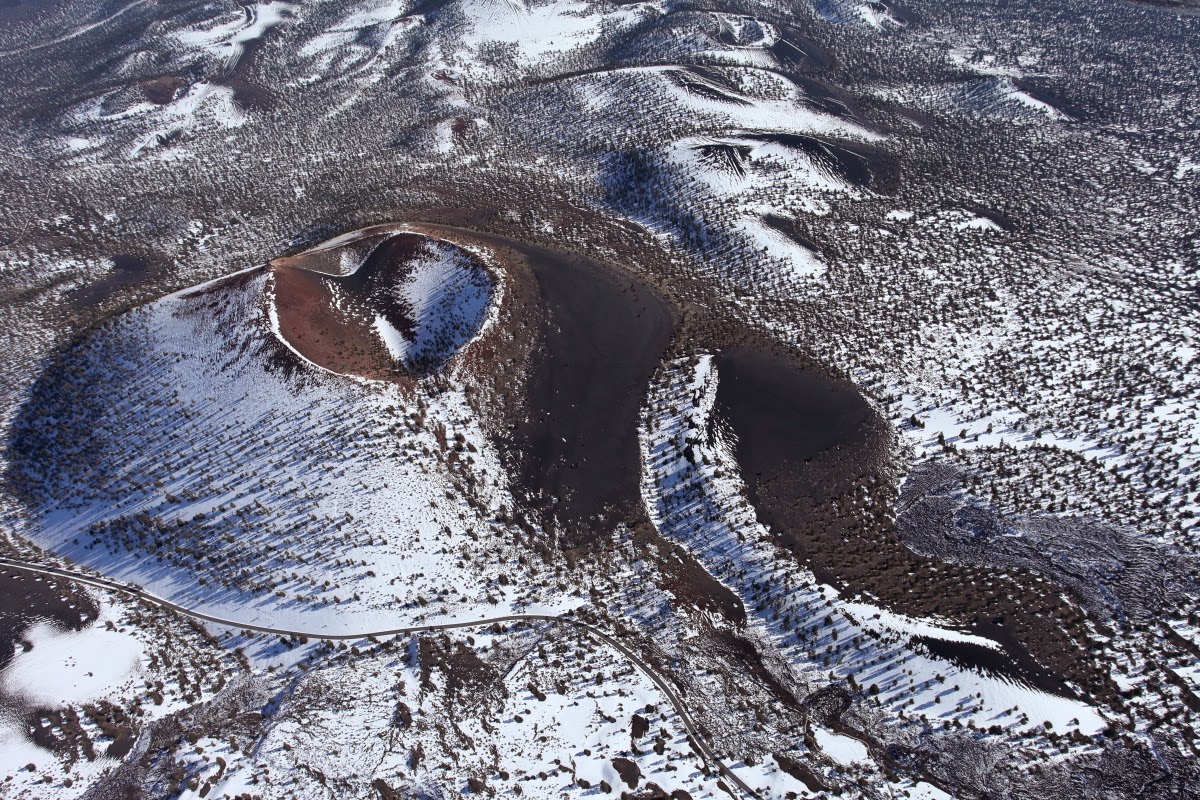
There's Sunset Crater, proclaimed a National Monument in 1930 to save it from partial destruction in the filming of a Hollywood movie (it was a screenplay of the Zane Grey novel "Avalanche" and the script called for a western town being destroyed by a mountain landslide).

Note the scenic road that trends through the snow in the bottom left. Ted also pointed out to me the heart-shaped crater or vent on top of the cinder cone. Sunset Crater erupted in the latter part of the 11th century.

Further east we see The Sproul (the elongate cone bottom), Merriam Crater (the highest cone), and North and South Sheba craters. Note how the south-facing slopes are devoid of snow while the north-facing slopes still retain it. These photos were taken about one week after the New Year's Eve snowstorm in northern Arizona.

To the northeast still is Roden Crater, with the Little Colorado River gorge in the background. People familiar with this area will also note the dark colored lava flow in the far upper right-hand corner that may have come from near Merriam Crater to the Little Colorado River (see more about this below).

Zooming in on Roden Crater.

Right over Roden Crater with the wing-tip (upper right) titled almost to vertical for the view. The circular feature in the center of the vent area is a large work of art that is being constructed by James Turrell. You can view images from the ground here. I haver has the pleasure of touring the site and it is incredible but not yet open to the pub lic.

Remember the lava flow from the first Roden Crater image above? Well that flow extends from its source for seven miles to the north where it intersects and crosses the channel of the Little Colorado River, running in this image from right to left (southeast to northwest). The gorge of the river is about 200 feet deep here and when the flow arrived at the lip of the gorge, red hot lava began to pour into it eventually blocking it. The river was forced to find a new channel around the lava dam and in the process created Grand Falls.

I include a ground photo of Grand Falls here, taken on March 2, 2008. Water from the Little Colorado River flows over the Permian age Kaibab Limestone as it re-enters its original channel downstream from the lava dam. The lava dam can be seen at the bottom of the photo and in the far upper right. Note the vehicles and people for scale standing on top of the lava dam near the upper right edge of the photo.

Back in the air with Ted we look downstream from the lava dam to the northwest. Note a former channel of the Little Colorado River opposite (right of) the sharp bend in the modern channel. It is a linear feature likely filled with dark-colored tephra (cinders) from Sunset Crater. Abandonment of this channel occurred some time before the modern channel was deepened.

Strawberry Crater and its lava flow. The typical cycle for these eruptions is: 1) magma is extruded into the air forcefully as droplets by the contained gas; 2) the droplets cool and fall around the vent as tephra, scoria or cinders creating a scoria or cinder cone; 3) the magma eventually becomes degassed and lava then wells up inside the newly created cone; 4) eventually the lava "pool" leaks out of the cone to create a lava flow. Most of the features here in northern Arizona show this sequence of events.

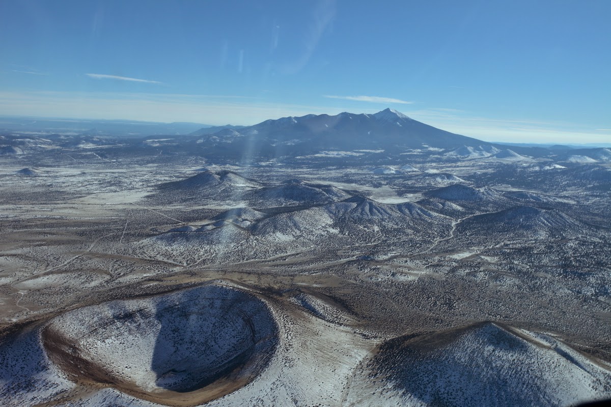
Colton Crater with its resurgent cone (located on the shadow line) within the much larger obvious cone.

Colton Crater below and SP Crater in the distance. Let's go have a look!

SP Crater is obviously a more recent feature due to its fresh appearance on the landscape. Not enough time has elapsed for soil to develop on it or its lava flow. The rest of the area is also underlain by lava rock but those features are much older and have more soil. Thus, the golden grass grows on top of the older features and highlights the relative recent nature of SP Crater.

Great view from right on top of SP Crater. Note how the degassed lava pool that was in the crater leaked out such that the flow extended about four miles downslope to the north.

View of the lava flow only with SP Crater out of view on the right. When the lava flow was active, the margins of the flow cooled first as they were pushed outward. This created natural lava levees that contained the hot flowing lava within. However, in two places this lava overtopped the natural levee toward the west. You can clearly see here two extra lobes of lava that broke through the main levee and traveled downslope into a valley, only to cool and consolidate here.

Turning around over Colton Crater and heading to the main volcano - San Francisco Mountain.

The Arizona Snowbowl ski runs on the slopes of Mt. Agassiz. Mt. Elden is in the background.

The highest mountain is Mt. Humphrey's at 12, 633 feet. I have hiked to the top many times. The San Francisco Peaks are the collapsed remnants of a once much higher cone, perhaps 3,000 feet higher and known as Mt. Coconino.

Coming in on Sedona 3 with glide power. There was not enough thermal lift on this winter day to do much gliding (ratio on this craft is about 30:1) but we did glide from beyond the Mogollon Rim into Sedona. Quiet and fabulous. Many thanks to Ted Grussing who graciously took me up on this fabulous day. Ted, I cannot wait to see what else excites up there!

Some facts about Ted Grussing's Lambada Motorglider:


Wingspan 15 meters with a glide ratio 30/1, or about 6 miles per thousand feet. Empty weight is 750 lbs. (includes oil in engine but not fuel). Two-seat side by side powered by a Rotax 912 ULS 100 HP engine. It is a tail dragger with steerable rear wheel. My normal initial climb rate when alone on an average air density of 6,000' is about 1700 fpm. I have the version with flaperons and it is very sensitive on the stick. Made in the Czech Republic by Urban Air now producing second generation as the Sundancer. Two wing tanks have useable fuel of about 26 gallons giving a range of about 1000 miles under power. Usually cruise cross country at about 80 kts air speed at 12,000' or higher giving me a ground track around 100 kts or about 115 mph and burning about 2.5 to 3 gallons of fuel per hours. My longest pure gliding flight in this ship is around 300 miles +/-.

Wednesday, December 31, 2014

Southern California's Blackhawk Landslide - An Impressive Catastrophic Event and Deposit - A Final 2014 Blog Posting

I wish everyone a Prosperous and Happy New Year in 2015! Thank you for reading Earthly Musings.

My wife and I recently visited relatives for the holidays in southern California and to break up the monotony of eating way too much food and visiting with people in indoor (TV) settings, we took a trip to the Mojave Desert and the Blackhawk Landslide. Ever since I was made aware of this huge feature, I have wanted to see and visit it. The best way to view the slide is from the air and since we did not have our own plane or drone delivered by Santa Claus, I include images found on the web. My images taken on the ground during our visit are also shown after the aerial pictures.

View to the northwest of the Blackhawk slide which is the lobe-shaped feature in image center
Photo credit: USGS web site: http://geomaps.wr.usgs.gov/archive/socal/geology/transverse_ranges/index.html
View to the south of the Blackhawk slide - hummocky terrain in image center
Photo credit: USGS web site: http://geomaps.wr.usgs.gov/archive/socal/geology/transverse_ranges/index.html 
Closer in view of the Blackhawk slide with the San Bernardino Mountains in the background 
Photo credit: Kerry Sieh. Image found on: http://www.lucernevalley.net/history/blackhawk.htm
This is how the Blackhawk slide looks from the air. But before humans could take to the sky, how was the slide recognized? It was by looking at the rocks found upon the odd, hummocky mass and taking note of their size and texture, and the mapping the extent of these rock types. It would be easy to see something like this from the air first and make an interpretation that could be verified on the ground. But the slide was first described by Woodford and Harriss in 1928 before the advent of common flight, who likened the deposit to one left by a large landslide in Elm, Switzerland in 1881. It was not until 1959 that Ronald Shreve completed his dissertation at Cal Tech, revealing that not only was this a catastrophic slide from the San Bernardino Mountains but that it was emplaced on a trapped cushion of air that ran out over the alluvial fan at over 50 miles per hour (80 km/hr).

MapQuest image of the San Bernardino Mountains and the Blackhawk slide (yellow). Faults are shown as red lines, with cities: Victorville, red circle; Lucerne Valley, blue circle; and San Bernardino, white circle. As the western edge of the North American plate is shoved by the impinging San Andreas Fault, the San Bernardino Mountains are upthrust to the north.
First, an introduction to the area is in order. The San Bernardino Mountains have been uplifted in the last 5 to 7 million years as the San Andreas fault impinges on this westernmost edge of the North American plate. Volcanic rocks erupted near Victorville in the Middle Miocene (12 to 15 Ma) are also found as clasts in fluvial deposits near Lake Arrowhead on top of the range. This means that before the San Bernardino Mountains were uplifted, drainage was to the south.

The San Bernardino Mountains in the background (south) have been thrusted up and toward the viewer. The thrust fault breaks the surface at the base of the mountains where the rock mass has been shoved up and north many miles over the desert floor.
Photo credit: USGS web site with annotations by Wayne Ranney

The thrust fault at the base of the northern San Bernardino Mountains is shown in the photo above. This upper block is composed of metamorphosed limestone and dolomite (marble) that is Pennsylvanian in age (about 300 Ma). These rocks correlate in time with the Supai Group in Grand Canyon and the Bird Springs Formation in the Mojave Desert. The thrusting pushes these relatively weak rocks out into open space in the Mojave Desert. Thus the Blackhawk slide is the consequence of rapid thrusting of weak rock that has collapsed into the desert.

Annotated image showing the Blackhawk slide and its source area in the San Bernardino MountainsPhoto credit: Kerry Sieh with annotations by Wayne Ranney
Now let's take a look at the Blackhawk slide on the ground. These photos were taken on our visit there on December 22 where we met Dr. Norm Meek of Cal State San Bernardino University.

We stopped on California Highway 247 to observe the distal end of the slide. It is the low hills on the skyline. The Blackhawk slide is about 5 miles long and 2 miles wide (8 km long and 3 km wide). It is between 30 and 100 feet thick (10 and 30 m thick).

Norm points out the slide with the western margin of the San Bernardino Mountains in the far distance.

We drove on a small mining road to the top of the slide. In the distance you can observe light colored disturbed areas where the Pennsylvanian age carbonates are being mined for cement.

Close-up view of the carbonate mine at the base of the San Bernardino Mountain. The thrust fault is below the lowest seen mine. Photo by Norm Meek.

Here is an exposure of the limestone on top of the slide. Note the original bedding which is still intact.

View to the north and the source area of the slide on Blackhawk Mountain. Note the light colored area beyond the closest yucca plants. This is where radiocarbon dates on freshwater (pond deposits) gastropod and pelecypod shells were obtained giving an age of about 17,400 + 550 years for the slide. Dr. Meek thinks that native carbon in the slide breccia may make this date too old and he suggests an age of around 14,000 years. It is interesting to speculate if the slide was purely from a gravitationally unstable overburden on the thrust. Or was it activated by seismic processes either from the thrust itself or movement on the San Andreas fault. Or was it facilitated by the pluvial Pleistocene climactic conditions at the time? Or could it be a combination of all three playing into its ultimate collapse?

The undisturbed upper surface of the slide looking northeast.

An small quarry on the northwest lobe of the slide provides both a view into the interior of the deposit and a blight on the slide. Shouldn't the geologic community petition for this feature to be set aside as an "Area of Special Geologic Interest?" It is located on BLM land and certainly there are other nearby areas to obtain gravel or marble for the construction business.

I enjoyed seeing an interior outcrop of the slide but the quarry looks to be a fair place for parties, trash disposal and general disrespect.

The wall of the quarry shows the near 100% composition of the clasts as Pennsylvanian marble. Helen and I enjoyed our short visit to the Blackhawk landslide. This is one of the largest such landslides that was mobile on a cushion of trapped air. It deserves to be protected and I hope you get to visit it one day. Happy 2015 everyone and thanks for reading!

Thanks to Dr. Norman Meek who took time out from his holiday to show us around. For a great outline of the geology of the San Bernardino Mountains, check out this USGS web page.

References

Woodford, A.O., and Harriss, T.F., 1928, Geology of the Blackhawk Canyon, San Bernardino Mountains, California: University of California Publications in Geologic Sciences, v. 17, p. 265-304.

Shreve, R.L., 1968, The Blackhawk landslide: Geological Society of America Special Paper 108, 47 p.

Shreve, R.L., 1987, The Blackhawk landslide, southwestern San Bernardino County, California: Geological Society of America Centennial Field Guide - Cordillera Section, v. 1, p. 109-114.

Saturday, December 20, 2014

I Have Some Exciting Trips Planned in 2015 - Join Me!

Many of the readers of this blog have traveled with me before to learn a bit about earth history and the evolution of landscapes. In 2015 I have a fantastic line-up of trips planned, both internationally and here in the Southwest. You can view a pdf of all of my trips here. There is no better way to travel than with your own personal geologist to explain what you are seeing. I hope to see you in 2015!

The Grand Canyon of the Colorado River - April 9 to 16 and August 22 to 29, 2015

The Green River in Canyonlands National Park - May 17 to 26, 2015

Imagine Flying Around the World on a Private Jet! Mongolia, Lake Baikal, Spitsbergen, Iceland, Greenland and more - June 9 to 30, 2015

Patagonia with Smithsonian Journeys - February 27 to March 16, 2015

Alaska River Adventure - The Tatshenshini River - July 16 to 30, 2015

Tuesday, December 09, 2014

Radio Interview with KVNF - Colorado Public Radio

At the Great Unconformity in Blacktail Canyon, Grand Canyon
I had the honor recently to sit down with JT Thomas of Colorado Public Radio and its local affiliate KVNF, which broadcasts to a wide area on the western slope of the Rocky Mountains (Paonia, Ridgway, Montrose, Ouray, Lake City and the Grand Valley). JT is a nimble and accomplished interviewer and this was one of the most satisfying I have conducted.

You can list to the full interview here. Thanks to JT, Ridgway, and Brad Wallis who facilitated this interview and my lecture there in June.

Friday, December 05, 2014

It Increasingly Looks Like It Was the Oak Creek Fault That Ruptured

Accumulating evidence increasingly suggests that it was the Oak Creek fault that is responsible for the November 30, 2014 M 4.7 quake in north-central Arizona. Phil Pearthree, Chief of Environmental Geology at the Arizona Geological Survey (AZGS) said, 

"The location is quite close to the Oak Creek fault zone, [and it is thought that] this fault has been active in the past 2 million years, but how recently it has ruptured in a large earthquake [is unknown]."


As reported previously on Lee Allison's blog, Dr. Pearthree has mapped the area extensively and reports that the epicenter location reported by the USGS is quite close to the Oak Creek Canyon fault. The AZGS fault map and data currently depict the northern part of this fault zone as "Quaternary" in age (the last 2 million years), as basalts of that age are displaced. 

Additionally, on December 3, I communicated with Dr. Richard Holm, a retired professor of geology at Northern Arizona University who completed a detailed mapping project of the fault in 1990 with graduate student Bob Cloud. An abstract of their paper in Geology can be found here. This is a seminal paper on the area and showed that nearly 1,000 feet of displacement occurred on the fault near Wilson Mountain (south of the recent quakes epicenter) since canyon volcanism ceased about 6.4 to 6.0 million years ago.

Dr. Holm had this to say about the recent quake and its possible relationship to the Oak Creek fault:

"Cloud and I (1990) show a dip of 77 degrees E on the Oak Creek fault at the head of the canyon, approximately 3 miles west of Sunday's epicenter. Using 3.0 [miles from the epicenter] and 6.4 miles [of depth], the trigonometry gives a dip of about 65 degrees east for a straight plane. But because there is evidence for a listric (curved) shape of the fault, the focus could reasonably be assigned to the Oak Creek fault."  Dr. Richard Holm (pers. comm.)

Figure 1 from Cloud and Holm, 1990 showing Oak Creek Fault
Obviously, incoming data and the interpretation of that data may change this scenario. But at this time, it is reasonable to assume that it was the Oak Creek fault (or the Oak Creek Canyon fault as it was initially called by Mears, 1950) that ruptured on November 30.

At a recent public event in Sedona on December 3, I was asked by an audience member what would be the significance of whether it occurred on the Oak Creek fault or some other fault. The only significance I can ascertain is that there has never been historical movement reported on this fault. For context, "historical" in this area might be 125 years or so. Since the Oak Creek fault is one of the major structural features in the Sedona/Flagstaff area, this would be of some concern if it is found that the fault is active.

Wednesday, December 03, 2014

The Lake Mary Fault Near Flagstaff


There is lots of talk in northern Arizona these days about earthquakes, since a moderate tremor shook Oak Creek Canyon (above) on Sunday, November 30.

This recent event makes me recall the time in 1993 when I taught a course at Yavapai College called "Earthquakes and Volcanoes of Northern Arizona." My research into providing lecture material for the class made me aware how this part of Arizona is very susceptible to strong temblors, as evidenced by a swarm of quakes that occurred near the San Francisco Peaks in 1906 (M6.2), 1910 (M6.0), and 1912 (M6.2). The latter one was so strong some cowboys camped on the north side of Peaks came screaming back into town thinking the world was coming to an end.

Because of my new-found awareness of earthquakes here, I called my home insurance company just to get a quote on earthquake insurance. The voice on the other end of the phone made an audible giggle and said, "You must be from California and new to the area as we don't have earthquakes in Arizona." I slowly gathered myself and told her that I was not new to the area but just curious about how much insurance would be. She replied that she would have do some research as she had never written a policy for earthquake insurance.

A week or more went by and wouldn't you know it, on April 29, 1993, a M5.3 quake rattled just south of the Grand Canyon near Valle, AZ  The quake was widely felt in NorAz and woke me up at about 2 AM. The next day I was reminded about the quote for insurance I never got and so once the offices were open, I called and said, "This is Wayne Ranney calling about a quote I requested." The lady who picked up quickly and excitedly yelled back to me, "HOW DID YOU KNOW??"

Of course, I didn't really know the when, I just knew the why and how. Geology is good for people that way. The end of the story is that the premium was not all that much but the $5,000 deductible (in 1993 dollars) was a deal breaker and I declined to get the insurance. I suspect there are very few policies written in NorAz for earthquake insurance but that there are a flurry of calls to insurance agents this week.


In relation to NorAz earthquakes, please take a look at this four minute video about the Lake Mary fault, located just south of Flagstaff. The production was made in 2011 and funded by the National Earthquake Hazards Reduction Program, with support from the Arizona Geological Survey, Arizona Earthquake Information Center, and AZ Shakes. This fault is about 25 miles long and is currently active, with its last movement in 2011.

We are likely to experience a quake at some time here but the recurrence interval is likely much longer than the average person's attention span for such things. As I travel often to many quake-prone regions - California, South America, the Middle East, the Pacific Rim - I am reminded more often than most of my peers to be earthquake aware all of the time.

Map courtesy of Jeri Young Ben-Horin at AZGS and Lee Allison, AZGS
And here is the latest map showing all of the foreshocks, main event, and aftershocks from the swarm. The foreshock is listed in red circle, M3.5.


Tuesday, December 02, 2014

Tuesday Update - November 30 Oak Creek Canyon Earthquake

Geologists have developed clever ways to peer deep beneath the earth's surface and these tools are being utilized to get a clearer picture of the November 30 earthquake in Oak Creek Canyon. In addition, aftershocks have been pretty regular since the 10:57 PM main shock.

Courtesy Google Earth with annotations by Jeri Young Ben-Horin at AZGS - Updated December 3, 12:05 PM
The purple object represents the epicenter of the M3.5 foreshock on November 25
Here is a Google Image provided by colleagues that shows how the epicenters for the aftershocks have migrated northeast from the main shock epicenter. The main shock is depicted as the red dot in the lower left quadrant. Note four aftershock epicenters at top center. These are located just west of Interstate 17 near the Newman Park exit. These aftershocks range from 4.7M to 2.2M and are located between the Oak Creek Canyon and Munds faults (faults on this image are shown as very light white lines and the Munds fault parallels I-17 on its east side).

This is one of the tools geologists use to understand quake and fault plane mechanics. On the left you can read the various location parameters. These are obtained from seismic stations around the globe and give data on specific location (epicenter), depth of rupture (focus), magnitude (strength of jolt), and more. On the right is a moment tensor diagram, often called the beach ball diagram. These show the trend and angle of the rupture in the subsurface, as well determine whether a break is compressional or extensional.

The moment tensor here shows some relationships to the Oak Creek Canyon fault but with a focus depth of 6.4 miles, it would seem that the epicenter should have plotted farther east on the surface if it was the Oak Creek Canyon fault that ruptured. This is not the case and suggests that some subsidiary fault might have broken. One could argue if this negates the rupture being on the Oak Creek Canyon fault but remember that most faults are actually fault zones with multiple strands that can rupture when stressed.

Perhaps a previously unmapped or blind fault is what is responsible for this quake. (Blind faults are those that do not rupture the surface and so cannot be detected until they rupture). Time and the reading of the data will tell.

Meanwhile, here are some comments sent to me from those who felt the quake late Sunday night:

Robert,  Sedona: "Huge rock Falls at thunder Mountain in West Sedona"

Christina, Flagstaff: "Okay, we had the earthquake... it about knocked me out of bed... But for me the weirdest, wildest thing that also helped me confirm that it was indeed a quake was that all the crows called out right after it hit... You just don't hear birds make sounds at 11pm at night... Creepy... very creepy."

Chris, Sedona: "I was asleep upstairs in our bedroom, while my wife was awake on the first floor. Then it happened. Arousing me early in the night is difficult, but I felt the shake stirring awareness of picture frames toppling and my rock collection rattling in synchrony. My wife came running upstairs thinking I had fallen out of bed. Never having fallen out of bed, I would guess it would be less than a 4.7, but I assured her it was only a quake.  Sleep did not immediately return."

Chuck, Cheshire neighborhood in Flagstaff: "It really smacked the house. It woke me but not fully so. I heard the stuff fall off the shelves behind my head and thought hey that was a quake. Then fell back asleep. Got up this morning and found the stuff on the floor and thought oh yeah hey that’s right there was a quake last night forgot all about it. And a minute later they mentioned it on the radio. Cheshire is built on a bowl of jello."

Sheri, Oak Creek Canyon, (maybe 5 miles from the epicenter): "Indeed, I felt it, it woke my husband up. It got my heart racing. . . I thought a huge tree had crashed our house.  Lasted about 10 seconds. All the kitchen drawers opened up. I thought it was scary, it was felt miles around us. PS - I thought your blog was very interesting, articulate, easy to understand."

Brenda, Sedona: "Slept through it. Would loved to have felt it. Haven't experienced one yet. Our cat acted crazier than usual in the middle of the night. A little nightlight in our bedroom that hadn't worked for months unexpectedly came on sometime in the night."

Mike, Sedona: "The quake sent a shock wave through my house, but none of my rock hoo-doos in the yard were toppled!"

Ron: "Thank You! I appreciate the look into the geologic past of this region. We live in Jerome and slept through it but many felt it here."

Marlene, Sedona: "As to the earthquake….we both slept through it!  Didn’t even know about it until I got to the library this morning. I hope there’ll be a bit more on the news tonight."

Pete, Flagstaff: "My experience was a small shaking, then a series of small rolls to the east, then a snap to the west, followed by some diminishing rolls. No loud bang heard/felt by others. Funny, experiencing the P, S and surface waves. I am about 15 miles from the epicenter in Country Club. First earthquake in Arizona but growing up in Southern California, I am familiar with seismic events."

Monday, December 01, 2014

Sunday's 4.7M Earthquake - What is the Oak Creek Canyon Fault?


Last night's 4.7 magnitude earthquake in north-central Arizona has everyone wondering about earthquakes in this part of the world. Some of these comments reflect a lack of understanding about seismic activity in northern Arizona. I have an entire chapter devoted to the Oak Creek Canyon fault in my book, Sedona Through Time, but here is a summary of the fault here.
Courtesy of the Arizona Earthquake Information Center
First, it's true that Arizona lacks the seismic punch that our California neighbor does, but we do get quakes here. After the Yuma area (located within the shadow of the great San Andreas fault) the Grand Canyon region is the second most seismic area in the state. It is not uncommon for quakes to occur here and last night's event may be a precursor to more activity, or it may just be a random rumbling. There is no way to know until after fact whether this is an isolated event or a foreshock of more to come. 

The Oak Creek Canyon fault is part of a series of extensional faults that form when the earth's crust is being stretched and Arizona has been stretched a lot in the last 20 million years. This extension is what makes the central and southern portions of our state look the way they do. Oak Creek Canyon is located at the far northern end of this zone of extension and so this explains the location of the Oak Creek Canyon fault. The fault is approximately 25 miles long and trends north right into the San Francisco Mountain stratovolcano. It dies out beneath lava flows south of the Village of Oak Creek.

Oak Creek Canyon fault has a very long history. It likely began in the Precambrian Era some 1,700 million years ago when pieces of crust were sutured onto the southern edge of North America. This same scenario is responsible for many of the faults in the Grand Canyon. During the Laramide Orogeny (70 to 40 million years ago) it was active again but this time the rocks were squeezed in a compression event. Finally, Basin and Range faulting began after 20 million years ago when the crust was extended or stretched.
Google Earth image of Oak Creek Canyon annotated by Wayne Ranney
In the Google Earth image above I have placed the fault on the landscape and show the location of the epicenter on last night's quake. The landscape on the western (left) side of the fault has been uplifted relative to the eastern (right) side. The amount of offset in the past totals about 1,000 feet near the area around Grasshopper Point. 

Along the fault, lava flows that are 6 million years old are broken. That means that the 1,000 feet of displacement began after 6 million years ago. As I stated in a previous post, I am unaware of any historical movement on this fault, remembering that "historical" covers about 125 years at the most. So this quake is significant in that respect.

Below are a series of slides from a lecture I oftentimes give in Sedona. They show how the fault has behaved in the past.

Aerial view to the north of the trace of the Oak Creek Canyon fault. Oak Creek Canyon is the obvious gash that trends north into the slope of San Francisco Mountain (upper right). The epicenter of last night's earthquake is in the upper part of the canyon after it makes a jog to the right.

The fault has separated lava flows found on Wilson Mountain and Wilson Bench by about 860 feet (see this reference for more information: Holm and Cloud, 1990). These lava flows were once continuous but movement on the fault separated them after 6 million years ago.

A second strand of the fault drops the rocks another 130 feet. this strand is very near the Grasshopper Point Recreation Area. The total offset on the two strands is nearly 1,000 feet. Remember that canyon carving could have occurred only after the faulting, since the creek follows the trace of the fault. The sequence of events interpreted from these observations are: 1) lava flow emplacement between 8 and 6 million years ago; 2) nearly 1,000 feet of fault offset occurred after the last flow (6 million years); 3) the canyon was carved. This makes the canyon very young geologically.

Next, if we portray the lava flows by their thickness and graphically show where the faults break them, it looks something like the diagram above. Note the scale at which the flows are faulted, 860 feet of offset represented on the left and 130 feet of offset on the right.

Geologists can "subtract" the total offset along the two faults and place the lava flows into their original orientation. This is depicted by the green wedge above. Note that this restoration shows how the flows become thin and pinch out to the west and thicken considerably to the east to over 500 feet thick.

The restoration shows that an ancestral valley or canyon existed in the area when the lava flows were erupted beginning 8 million years ago. This valley extends eastward about 18 miles where the flows thin again against the bedrock at Hollingshead near Beaver Creek.

I hope this helps in the understanding of the Oak Creek Canyon fault. Stay tuned for updates.

Earthquake Last night in Oak Creek Canyon

From USGS web site
A moderate 4.7 magnitude earthquake with an epicenter in Oak Creek Canyon woke me up here in Flagstaff just a few minutes before 11 PM last night. Woken from a moderate sleep, at first I knew it was an earthquake - but then passed it off as a dream and went back to sleep. It seemed to have a jolt followed by about 3 seconds of shaking that gradually diminished.

The news coverage has been good this morning. The earthquake summary can be found here on the USGS web site: http://earthquake.usgs.gov/earthquakes/eventpage/usb000t1hf#summary. Looks like the focus was at a depth of just over 6 miles (an earthquake focus is the exact place within the earth where the crust broke to create the quake). The epicenter (defined as the place on the surface directly above the focus) was located seven miles north of Sedona and just east of the Butterfly Garden Resort in the canyon. A preliminary view of the epicenter suggests this quake likely occurred along the Oak Creek Canyon fault.

Epicenter of quake labeled as #1 on this image courtesy of John Parsons
The satellite image above shows Oak Creek Canyon and the epicenter labeled as #1. The red 2 is Junipine Resort, 3 is the AB Young Trail, and 4 is the Butterfly Garden Inn (the former Don Hoel Cabins).


Twitter carried a picture of rocks and trees on Highway 89A that were let loose during the shaking.

I will make updates as they become available.