
Friday, July 26, 2019
Northern Arizona Argillite
Monday, July 22, 2019
UPDATE: The July 2019 Ridgecrest Earthquakes - Odd Indeed But Not Surprising
July 22 UPDATE: The Los Angeles Times has published striking images of the fault ruptures across the Ridgecrest area in stunning before and after photos. Check out the images here.
July 8 Posting
I grew up in southern California and earthquakes have been a part of my life since I felt my very first one in the 1960s. My family still lives there and as a geologist I always remind them to be mindful of the tectonic "gold mine" they sit on top of. I guess geologists may be the only ones (besides home repair stores) that think of earthquakes in not strictly negative terms.
I happened to be in southern California at my cousin's wedding when the June 1992 Landers earthquake hit and when it rattled the windows and sloshed the pool water outside our hotel room, the person laying next to me asked what was happening and then what we should do. The only thing I could think of (naturally) was "earthquake" and "just lay here and enjoy it."
So when I heard about the July 4th earthquake that ruptured the ground near Ridgecrest California, I couldn't wait to see the first images (below).
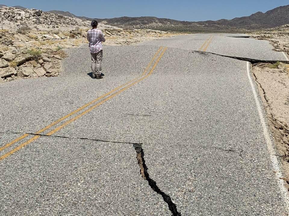
 Photo showing how the pavement cracked during the rupture event, produced during the July 4 M 6.4 quake. Look closely at the painted lines. (Photo courtesy of Emily Guerin/LAList)
 This is a view looking straight down on one of the ruptures. Note that no matter which side of the crack you stand on, when you look to the other side across the crack, the line shifts to the left. This is called left-lateral displacement. (Photo courtesy of Emily Guerin/LAList)
 Additional ruptures from the July 4th earthquake near Ridgecrest.
When I saw these photos, they caused me to ponder this event more closely knowing that the famous San Andreas system of faults has right-lateral displacement. This breakage didn't seem to follow that pattern. However, there is another fault that abuts the San Andreas in a perpendicular fashion and I immediately thought of it as a possible fault for this earthquake - the Garlock Fault. (Photo courtesy of Emily Guerin/LAList).
 Map used from the California Seismic Safety Commission showing the Garlock Fault system and its relationship to the San Andreas system.
As it turns out, this July 4 event happened just to the north of the Garlock Fault, on a previously unknown fault (but the offset was in the same sense as the Garlock - left lateral). It's likely that the break on this event was related to the larger Garlock Fault system.
Then on July 5, another large quake, this time registering 7.1 occurred on a fault perpendicular to the fault that slipped on previous days quake. And this rupture curiously showed right-lateral displacement (see photos below).
 Note here that no matter which side of the fault you are standing, when you look across to the other side the displacement is to the right. (Photo by Beth Hadden)
 Aerial view of the same area (Photo by Brian Olsen).
A really good article on LiveScience about the displacements and the faults can be found here.
I often get hopeful when news organizations announce an upcoming story about these earthquake events. But invariably, these stories turn into human interest pieces that really have nothing to do with geology, the crust or how brittle substances behave under stress. I guess most people wouldn't care about that. But then, maybe they should label their stories, "How People Are Affected and Are Reacting to the Recent California Earthquakes."
The asthenosphere, a portion of the upper mantle that is hot and pliable - all while remaining a solid - churns slowly beneath the brittle lithosphere that we all live on. As the asthenosphere slowly creeps, the brittle lithosphere must respond to the tugging motion from below. Occasionally, the brittle lithosphere cracks under stress and a rupture and earthquake occur.
I often use an example that many people can visualize - imaging holding a Snickers candy bar with both hands and moving your hands in the opposite direction. Then look at the chocolate covering the candy bar and watch how subparallel cracks grow as the bar is progressively deformed. The picture above is a great example of this as well!
The "Big One" is coming for southern California. But engineers and geologist have been preparing for it and there may be no better place to experience a big jolt, except for other First World, quake-prone areas like Japan, China and Chile. Quakes rarely kill or injure people but falling objects do. My initial response to my bedmate in the 1992 Landers quake may have been cute in some sense, but it was potentially quite dangerous had we been nearer to the epicenter. When you feel it start to shake, look around and head away from anything that can fall on you. And then, sit back and feel the rumble of a force much greater than us mere humans.
July 8 Posting
I grew up in southern California and earthquakes have been a part of my life since I felt my very first one in the 1960s. My family still lives there and as a geologist I always remind them to be mindful of the tectonic "gold mine" they sit on top of. I guess geologists may be the only ones (besides home repair stores) that think of earthquakes in not strictly negative terms.
I happened to be in southern California at my cousin's wedding when the June 1992 Landers earthquake hit and when it rattled the windows and sloshed the pool water outside our hotel room, the person laying next to me asked what was happening and then what we should do. The only thing I could think of (naturally) was "earthquake" and "just lay here and enjoy it."
So when I heard about the July 4th earthquake that ruptured the ground near Ridgecrest California, I couldn't wait to see the first images (below).


When I saw these photos, they caused me to ponder this event more closely knowing that the famous San Andreas system of faults has right-lateral displacement. This breakage didn't seem to follow that pattern. However, there is another fault that abuts the San Andreas in a perpendicular fashion and I immediately thought of it as a possible fault for this earthquake - the Garlock Fault. (Photo courtesy of Emily Guerin/LAList).

As it turns out, this July 4 event happened just to the north of the Garlock Fault, on a previously unknown fault (but the offset was in the same sense as the Garlock - left lateral). It's likely that the break on this event was related to the larger Garlock Fault system.
Then on July 5, another large quake, this time registering 7.1 occurred on a fault perpendicular to the fault that slipped on previous days quake. And this rupture curiously showed right-lateral displacement (see photos below).

A really good article on LiveScience about the displacements and the faults can be found here.
I often get hopeful when news organizations announce an upcoming story about these earthquake events. But invariably, these stories turn into human interest pieces that really have nothing to do with geology, the crust or how brittle substances behave under stress. I guess most people wouldn't care about that. But then, maybe they should label their stories, "How People Are Affected and Are Reacting to the Recent California Earthquakes."
The asthenosphere, a portion of the upper mantle that is hot and pliable - all while remaining a solid - churns slowly beneath the brittle lithosphere that we all live on. As the asthenosphere slowly creeps, the brittle lithosphere must respond to the tugging motion from below. Occasionally, the brittle lithosphere cracks under stress and a rupture and earthquake occur.
I often use an example that many people can visualize - imaging holding a Snickers candy bar with both hands and moving your hands in the opposite direction. Then look at the chocolate covering the candy bar and watch how subparallel cracks grow as the bar is progressively deformed. The picture above is a great example of this as well!
The "Big One" is coming for southern California. But engineers and geologist have been preparing for it and there may be no better place to experience a big jolt, except for other First World, quake-prone areas like Japan, China and Chile. Quakes rarely kill or injure people but falling objects do. My initial response to my bedmate in the 1992 Landers quake may have been cute in some sense, but it was potentially quite dangerous had we been nearer to the epicenter. When you feel it start to shake, look around and head away from anything that can fall on you. And then, sit back and feel the rumble of a force much greater than us mere humans.
Saturday, July 20, 2019
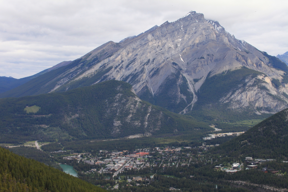
Thrust Faults, Landslides, and Glaciers - Geologic Gems of Jasper and Banff National Parks, Alberta Canada


Slow time exposure of the falls in Maligne Canyon.


Wednesday, July 17, 2019
Waterton (Canada) and Glacier (USA) National Parks
We drove south out of Calgary on Highway 2 to Pincher Creek on our way to Waterton National Park.
 There are fields and fields of canola growing everywhere on the southwestern Alberta prairies.
 Finally, the Rockies come into view.
 It's the heart of summer here with flowers everywhere. Note the low gap in the mountains (top center) - that is the valley of Waterton Lake.
 Waterton Lake was carved by Pleistocene glaciers and the international boundary runs across this view about halfway up the lake. The village of Waterton can be seen to the right.
 The lake is held back by a terminal moraine, seen on the left. I am standing on the moraine in front of the Prince of Wales Hotel. Waterton Lake is about 300 feet deep.
 Barron Falls in the village of Waterton.
 After leaving Waterton, we crossed the international boundary within Glacier National Park and soon saw one of the parks biggest features - Chief Mountain. The upper cliff is composed of Proterozoic sedimentary rocks about 700 million years old that have been thrust eastward (toward the photographer) about 50 miles. It all happened in the subsurface around 100 million years ago and subsequent erosion has removed about 2 miles of material, leaving Chief Mountain standing tall.
 In the opposite direction lie the Great Plains, so called now that this is the United States. I find these wide open spaces to be just a bit more satisfying than the forested mountains in the other direction (although I like them both). I do like to see a long way.
 Chief Mountain and the Montana sky.
 We stayed in St. Mary on the Blackfoot Indian Reservation and adjacent to the Park. Looking west, we can see where the Lewis Thrust has placed much older Proterozoic sedimentary rock (dark gray) on top of light-colored Cretaceous limestone. Chief Mountain lies behind this wall to the north.

 The Blackfoot tribe has established a nature walk with wonderful metal artworks near St. Mary and a metal tipi can be seen in the middle distance.
 A huge lenticular cloud formed over us while we were taking in the view.
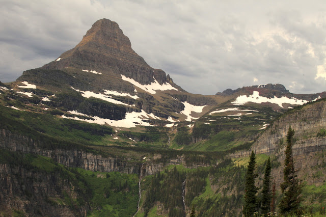
 Zoom shot looking west up to Fusillade Peak at the head of Lake St. Mary.
 A closer view of Fusillade Peak from a boat on Lake St. Mary. Note the bedding in the strata. These rocks belong to the Belt Group and specifically the upper snowless peak is part of the Snowslip Formation (tidally-dominated shale and sand), while the lower, snow-clad rocks are part of the Helena Formation (shallow marine limestone).
 Crown Island is a much photographed feature on Lake St. Mary. Little Chief Mountain is on the left.
 Near Logan Pass on the Continental Divide. Just to the left off of the photograph is a triple divide where water flows to the Missouri River via Cut Bank Creek and the Marias River; to the Columbia River via Pacific Creek and the Flathead River; and the Saskatchewan River via Hudson Bay Creek and the St. Mary River. Three drainages on their way to the Gulf of Mexico, the Pacific, and Hudson's Bay and the Atlantic.
 At Logan Pass I noticed this limestone algal mound, which is a buildup of algae within the Helena Formation.
 Close-up of the mounded laminae that formed when algae grew upwards through fine-grained lime mud.
 Two mounds can be seen here in front of the Visitor Center. No one seemed to notice these gems and there was no sign announcing their presence.
 The weather is always "iffy" up north but it was dramatic.
 The famous red busses in front of the Lake McDonald Lodge.
 The interior lobby of the Lake McDonald Lodge.
 Kayakers on Lake McDonald, a glacially carved body of water.


The U-shaped valleys of the Rocky Mountain front near St. Mary, Montana.


Subscribe to:
Posts (Atom)