We transitioned to the South Island and an arrival in Christchurch just two weeks after the shootings. The South Island is much different than the north with fewer people, higher mountains and one very large transform fault, the Alpine Fault.
Map showing our route across the South Island. The right lateral Alpine transform fault runs along the western side of the Southern Alps and goes offshore just north of Doubtful Sound. Originally, Moeraki and Dunedin were not on the itinerary but the bridge to the Franz Josef Glacier was washed out days before we were to arrive. Up to one meter of rain (40 inches) fell there in a 48-hour period, washing out the bridge and our plans had to change.
To say that the city was shocked at what happened would not convey the depth of it all. Things like this do not normally happen in quiet, little New Zealand. Yet, it did. I was amazed at the way the Kiwi's came together as a nation after this. The path forward seems clear to just about everyone here.
Our Tour Director had a friend in Christchurch who made a bundle of red roses for each member of our group...
...and we placed them on the heap of flowers that has been growing for two weeks. The memorial garden is nearly 1/2 a kilometer long! There was a great sense of respect while we were here. Tears were shed.
This is the statue to Robert Falcon Scott (the leader of the second group to stand at the South Pole in 1911) along the Avon River in Christchurch. The statue was toppled in the February, 2011 earthquake and has only been replaced within the last year.
Here is a photo of the same statue I took in October, 1986 on my first trip to New Zealand. All of the buildings in the background were destroyed in the earthquake and are no longer there.
Christchurch is looking to the future. It was once the "Most British City" outside of England. But no longer. The earthquake leveled many buildings downtown and there are being replaced with more modern-looking, earthquake resistant designs.
Map showing the epicenters and location of aftershocks from a series of earthquake events near Christchurch between September, 2010 and December, 2011. The red dotted line below the Sept. 2010 date shows the blind fault (previously unrecognized) that ruptured transverse to the Alpine Fault. This first quake had the largest magnitude of the four major shocks, making all others (by definition) aftershocks. The February, 2011 quake was the most damaging to the Central Business District and 185 people lost their lives due to structure collapse. Note the rounded Banks Peninsula sticking out into the Pacific Ocean, a heavily eroded, late Miocene volcano between 9 and 11 million years old.
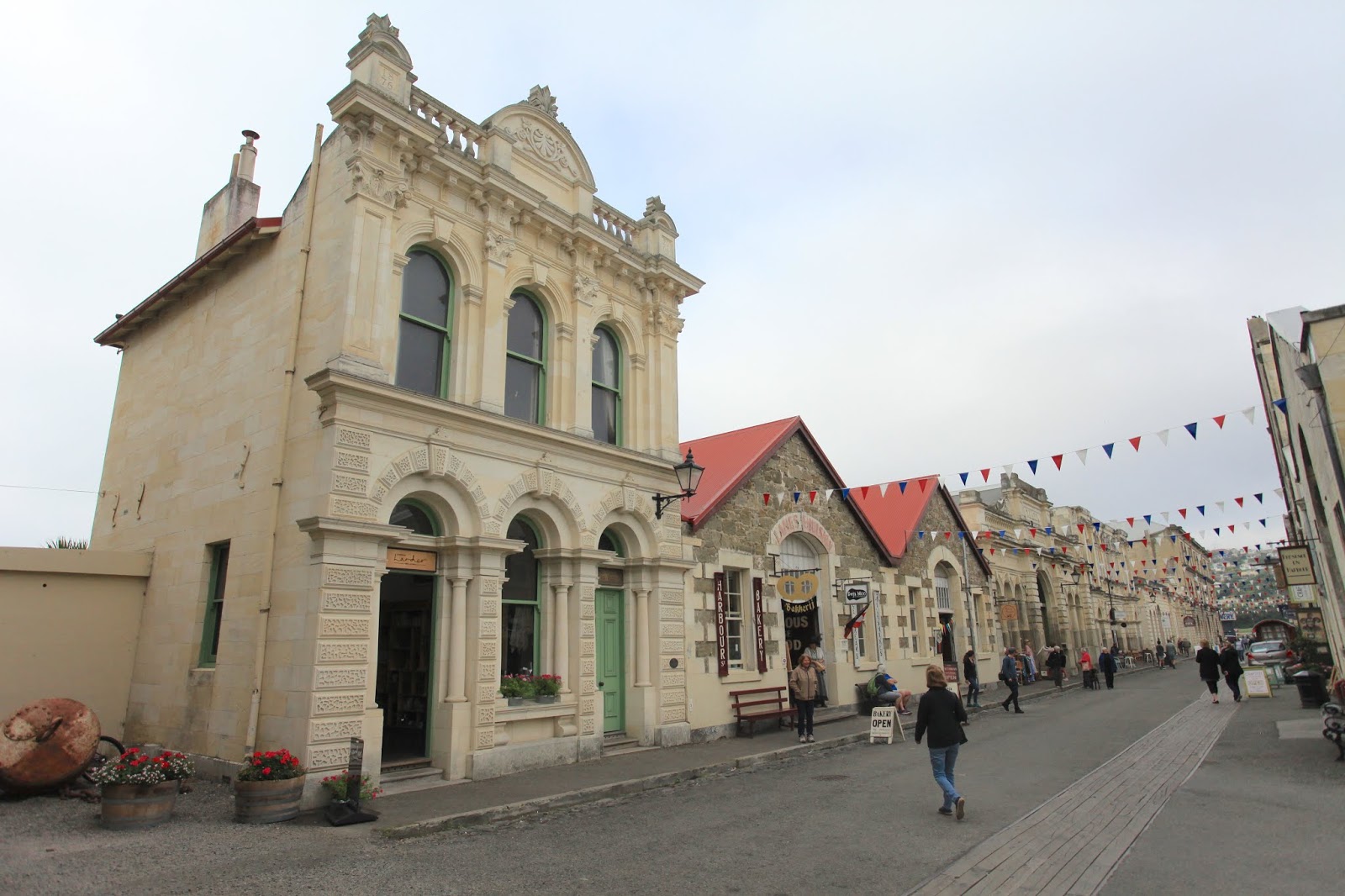
We were supposed to ride the train over the Southern Alps to Franz Josef Glacier but heavy rain closed the roads and the railroads. So we went south and passed through an interesting looking town called Oamaru, known for its limestone buildings.
The limestone is quarried nearby.
Much of the town's architecture has been preserved.
And gentrified.
Savory pies are a staple in New Zealand and in this out-of-the-way shop I enjoyed a Thai Green Rice pie, absolutely the best that I had on this trip. There is a dominant sentiment that I detected in New Zealand that diversity in the population is welcomed and beneficial to the country.
Next stop down the east coast was the
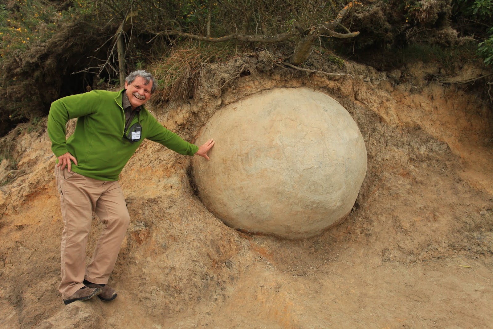
Moeraki Boulders. I had first heard of these strange beach rocks as a young geology student in the 1970s but this was my first visit to them.
They are technically septaria nodules (also called concretions) and formed in a 60 million year old mudstone, the Moeraki Formation.
Here is a view of me next to one nodule still in place within the mudstone in the sea cliff.
The waves from big storms have cracked some of the boulders, allowing us to see the inside structure.
The septaria (cracks) are composed of calcite that has grown in the voids.
A last look at the boulder-strewn beach and cliff behind it.
Next stop Dunedin, a town of Scottish heritage and a large university, the
University of Otago.
Map showing the location of Dunedin at the head of the Otago Harbor. Note the circular nature of the peninsula - like the Banks Peninsula near Christchurch, this is a 16 to 10 million year old volcano that has been heavily eroded in the last 10 million years. See more about the Dunedin volcano
here.
The old railway station is a fine example of the architecture in this city. It is made of dark basalt blocks that are framed with Oamaru Limestone.
The New Zealand Pigeon (
Hemiphaga novaeseelandiae) was seen on the top of a tree as we toured the Otago Peninsula.

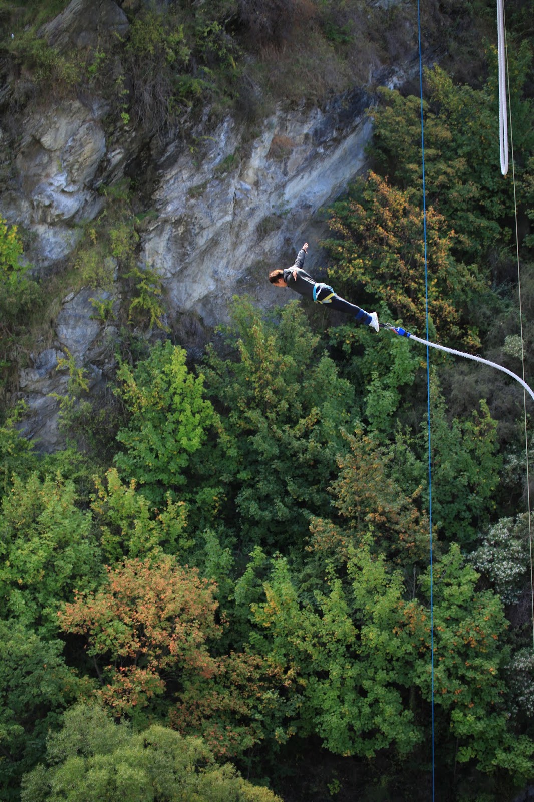
As we made our way toward Queenstown, we stopped at the Kawarau Bridge where the sport of bungee jumping was invented. We arrived in time to see this person take the plunge.
He really had beautiful form with a nice, swan dive off the deck and a gentle curve down to the river. I would really like to be able to do this but I know that I would chicken out on the deck. It's too close to the earth. I would jump out of an airplane (again) in a heartbeat - it's high enough up for me.
You can request to barely touch the water - they have the length of the bungee down to a science - and this guy chose to do it.
The rebound back up toward the bridge looked to be the most fun and this guy made it more than half way back up!
The big excursion out of Queenstown was a day-long trip to Doubtful Sound. This is a map showing the Fiordland National Park, encompassing 3 million acres of pristine, virgin forests and deep fjords. The Park covers all of the mountainous terrain in the center of the map. There are 14 fjords that indent the coast.
The trip includes a boat ride across the freshwater Lake Manapouri, then a bus ride over Wilmot Pass, then on another ship on Doubtful Sound. The rocks in much of the Park are Cretaceous granite and gneiss, intruded when New Zealand was still attached to the Gondwana supercontinent.
Slide from one of my lectures showing the position of the southern continents during the Jurassic. Subduction occurred where the word New Zealand is located and the subducted slab melted at depth with the granite in Fiordland forming on the continental side of New Zealand.
The clouds lifted as we passed the Southern Arm of Lake Manapouri. This was incredible as this area gets an average of one inch of rain very day - an average of 360 inches per year.
The Captain took us on a side trip up the Northern Arm to show us these dikes running through the granite. The dikes are differentially eroded with the granite softer than the dikes.
Whoa - what a day! I love these clouds. High cirrus in Fiordland!
These are better exposures of the granite.
From Wilmot Pass we obtained our first view of Doubtful Sound, named when Captain James Cook doubted that he could turn the H.M.S Endeavour around in the narrow fjord. The road we were traveling on was constructed in the 1960s when a hydroelectric scheme was installed on Lake Manapouri. Read about this interesting and controversial project
here. New Zealand's first nationwide environmental controversy ensued because of the project, ending in a compromise with the scheme being completed but without raising the natural level of Lake Manapouri.
Zoom lens view of Doubtful Sound.
Not a cloud in the sky. How does one do field geology in a place covered in vegetation?
A perfectly eroded U-shaped valley in the upper end of Doubtful Sound. The amount of ice that was here just 14,000 years ago is impressive.
We made it all the way out to the mouth of Doubtful Sound and the Tasman Sea. Only 2,000 miles to Tasmania! Doubtful Sound is not technically a sound, although that is the name Captain Cook gave it. A sound is a shallow river valley that has been submerged beneath rising seas (or sinking land). When Cook sailed here, geology as a modern science was not yet invented. Neither was the definition of a fjord known to the British. A fjord is a glacially carved, sea-flooded entrant on a coastline.
These tree ferns on the shore were so damn photogenic. The vegetation in New Zealand has suffered much from the arrival humans but in Fiordland National Park Park, it is preserved. This reminded me of what the forests in Gondwana might have looked like.
Another side arm in the fjord.
This concludes my trip to New Zealand. I'll be back next year with Smithsonian Journeys.