Next stop on the big trip Around the World was the Lost City of Petra in Jordan.
This is the new entrance gate to the site, the first time I have seen it. It is a very nice approach compared to what it used to be. Admission to the site - $62 per person.
As one starts down the trail, the red rocks begin to appear above the stream bed. The name of the rock unit here is the Rum Sandstone of Cambrian age (about 500 Ma).
One immediately sees the carved sandstone as they enter the Siq - the name in Arabic for slot canyon.
To prevent flash floods from damaging their rock city, builders placed a dam across the bed of the Siq (a modern version is seen beneath the white building). This diverted flood waters toward a 300 foot culvert carved through solid sandstone and into another nearby drainage. The sites development began around 200 BC and lasted about 400 years until 200 AD.
Entering the narrow part of the Siq.
Note the domestic water channels at eye level carved into the slot canyon walls.
The Rum Sandstone is riddled with
Liesegang banding, concentrations of iron that formed when groundwater fronts (prior to canyon cutting) dissolved iron in one part and pushed it downstream into other parts where it concentrated as layers irrespective of depositional bedding. Here, dark colored iron bands frame a water channel in the canyon walls.
The slot canyon is about 300 feet deep and at its narrowest part is only 10 feet wide.
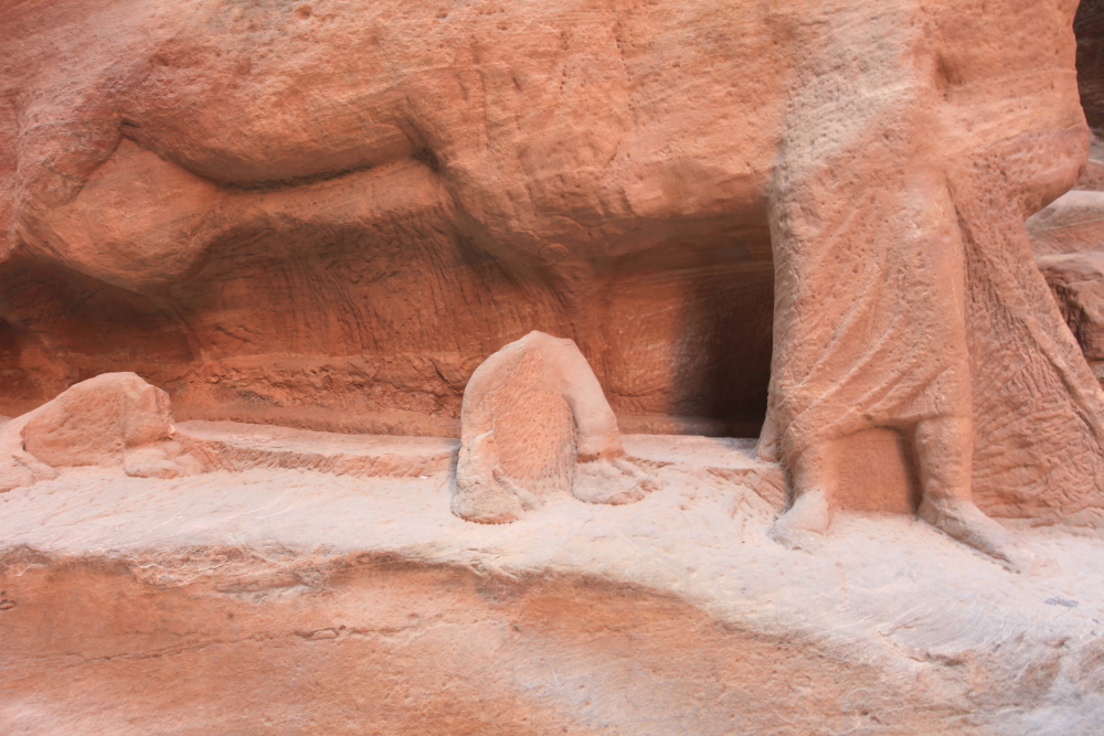
These remnants of a carving along the canyon wall shows a man leading a camel (the camel feet are in the center and left of photograph). The carvings appear to have been scoured by flood water, likely after the city fell into ruins.
This is the end of the Siq as it enters the larger stream. I doubt that many photographs of this spectacular end to the kilometer-long slot canyon are taken because...
...when one turns the other way, they see one of the most famous and magnificent mausoleums in the whole complex, a carved structure known as the Treasury. All of these buildings were constructed as mausoleums for the rich and it is presumed that the larger the mausoleum, the richer the benefactor.
Close-up of the Liesegang banding in a canyon wall.
A theater was also carved into the sandstone. The theater was carved in the 1st century AD, before the Roman occupation. However, the similarity of the architectural design however suggests a sharing of ideas between the Nabateans and the Romans.
This magnificent structure was a very large mausoleum. Look at the amount of material removed from the natural slope on the left. The sandstone is relatively soft but hey, rock is rock.
Natural light fills the mausoleum. Note the spectacular Liesegang banding on the roof.
The tombs were raided of their contents likely quite soon after the site was abandoned. Although Petra is often called the Lost City in the Western world, the local population never lost sight of the ancient city.
On May 19, 363 AD, Reqem (as the Nabateans called their Rose City) was destroyed by a massive earthquake. Here a column lies prone - it may or may not have fallen during the quake. A short article on the quake can be found
here.
After lunch we walked one mile and 700 feet up to the Monastery, another great mausoleum but this time located out of the canyon floor and on a high ridge.
The view to the northwest is toward the Dead Sea rift valley. The Jordanian flag flies in the breeze.
A few years ago, I noticed that the red sandstone rests on dark colored Precambrian crystalline rocks. In the American Southwest this contact is known as the Great Unconformity and one could rightly use that term here (and elsewhere in the world). I have seen such a contact in Cape Town South Africa, Australia, Saudi Arabia, and Antarctica.
A photo with the 300mm telephoto lens reveals some interesting geology. In the upper left background, white Cretaceous-age limestone has been faulted down and rotated into the Dead Sea rift. The amount of displacement is thousands of feet. I never noticed it before but with the telephoto view, another rock unit can be seen located between the red sandstone above and the dark crystalline rocks below. It is the vertically jointed massive unit in the photo center and it is composed of
late Precambrian rhyolite and andesite.
A juniper tree frames the view.
On the way back down I took a camel ride through the city. This completes my journey to Petra in 2017.
The following day our group visited Wadi Rum, a location made famous when featured in movies such as
Lawrence of Arabia and
Indiana Jones - The Last Crusade. The Great Unconformity is visible in this view at the center of the photo.
The Rum Sandstone takes on familiar shapes to anyone schooled in the southwest deserts of Arizona and Utah.
I have never seen such well-developed
case-hardening (and related core softening) in a sandstone. It forms when groundwater dissolves cement in the interior of the sandstone, then groundwater brings the solution to the rock surface where it evaporates, leaving the cement on the wall and making it harder.
Entering a slot canyon in Wadi Rum.
The petroglyphs take forms not familiar to New World archaeologists. An old Arabic script before dots is also present in these carvings, dating to about 2000 years ago.
A geologist had obviously been here to take oriented cores from the iron-rich rocks. These were taken to determine the magnetic orientation of the iron, which can help determine the latitude of the rock during deposition.
The final stop on this trip is the Atlas Mountains in Morocco.