In mid-July I got to raft the Colorado River where it transitions to the red rock country of the Colorado Plateau. Horsethief, Ruby, and Westwater canyons are the first red rock canyons that the river flows through and we completed a 54 mile trip through them. Surprisingly (for this time of year), the river was running quite high flowing at just over 20,000 cfs (cubic feet per second). This volume contained the last of the spring snow melt from the high Rockies as well as recent inputs from monsoon rain.
The trip begins just downstream from the confluence of the Colorado and Gunnison rivers, near the town of Loma, Colorado. A canopy of cottonwood trees lines the river here and once away from shore, I took a picture in the upstream direction. The rocks in the far distance are rather young lake deposits about 60 million years old.
A mature bald eagle stood sentinel at the entrance to Horsethief Canyon.
Unlike the central portion of the Colorado Plateau, the Navajo Sandstone has either pinched out or changed facies in westernmost Colorado. Behind the far cottonwood trees you can see a bit of the Wingate Sandstone. The darker layered beds above it belong to the Kayenta Formation. But even though it looks similar to the Navajo Ss., that is the Entrada Sandstone forming the high cliff. The reason for the absence of the Navajo and Carmel Fm. here is that this was the flank of the Ancestral Rocky Mts. and it was not part of the depositional basin at that time (about 190 to 170 million years ago). Can be confusing at first but it has been worked out by stratigraphers.
The Kayenta Formation at River level capped by the Entrada Sandstone in Horsethief Canyon.
This is a view downstream of the Rattlesnake monocline, where the strata were compressed and upturned during the
Laramide orogeny.
On day 2 I took this picture at sunrise of our rafts in Mee Corner camp. The river was whistling by at about 6 mph and became quite muddy from runoff overnight. Huge logs were seen drifting by.
We had time to hike up to the top of the cliff behind camp.
About 250 feet above the river lies a deposit of Colorado River cobbles. The suggestion is that the river has incised its channel 250 feet after these were laid down and they have become perched above the modern channel. Cobbles like these are the actual cutting agents that help rivers deepen their canyons.
A old juniper tree leans out over the mighty river. Prior to 1921, this stretch of it was known as the Grand River (thus the names that remain in the area - Grand Junction, Grand County, Grand Mesa, etc.). But in that year, the Colorado State Legislature, in an attempt to secure more water rights for the state, petitioned a federal commission to have the name changed. Prior to that change, the Green and the Grand flowed together downstream to create the Colorado River. See more about this name change
here.
Every morning while in Ruby Canyon, the Amtrak Zephyr would come by about 10:30 AM. This rail line only saw about 5 trains in a 24 hour period. In Flagstaff, we get that many in an hour.
Another beautiful fold in the strata in Ruby Canyon.
As we approached our second nights camp we entered a shallow gorge cut into Precambrian age granite. These rocks are the same age and general composition of the Vishnu Schist in the bottom of the Grand Canyon. But take a look at the deposit that overlies it - that is the Chinle Formation. In the Grand Canyon, the schist is mostly overlain by the much older Tapeats Sandstone and 4,000 feet of other strata. That means that here in Ruby and Westwater canyons, the great unconformity is even greater than in the Grand Canyon! it is 1,500 million years duration here; in Grand Canyon it's only 1,200 million years. The reason? Again, it is the former presence of the
Ancestral Rocky Mountains, which had all of their Paleozoic strata stripped off of them before the Chinle Formation finally buried this part of the ancient range.
Here is a close-up of the rock from behind our camp. The rectangular flecks are potassium feldspar crystals that grew in the magma as it slowly cooled.
Here two dikes cross one another with the granite. Can you see which dike occurred first? Since the dike in the lower left corner is offset slightly by the other one (look where the two cross each other), it must be the older dike - how else could it have been cut if it wasn't already there.
Steamy morning after a night of rain in Ruby Canyon.
A beautiful grove of cottonwood tress lines the Grand River (sorry - I think the name change is something that should be reversed - now that the water allotment has been determined). A cliff of Entrada Sandstone is capped by the Morrison Formation behind the trees.
Same thing here with a tilt in the strata. This marks the entrance into Westwater Canyon.
The Precambrian/Triassic unconformity rises again from beneath the depths. The rocks here are composed of high grade metamorphic types. At this point I put the camera away for about 7 miles. This is the whitewater stretch of the trip and I wasn't willing to take a chance. The rapids were mostly washed out at this water level but it still was a bit tense as we rode one long rapid where normally there are 8 or 9.
When we exited the whitewater stretch, the Precambrian gorge was almost 100 feet deep.
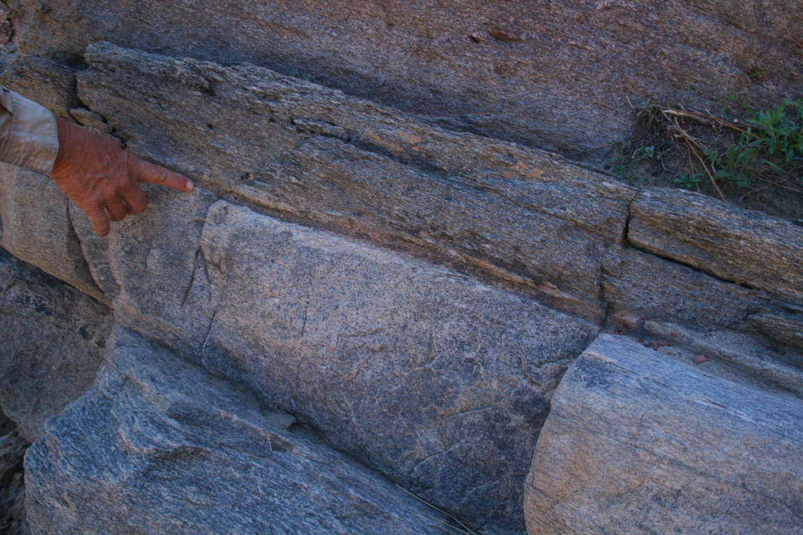
Once we landed at our third camp (Bighorn), we saw that the grade (or intensity) of metamorphism was much less here than it was back upstream. Visible here is evidence for the original rock types prior to metamorphism. The more massive, light colored rocks below the persons finger used to be sandstone until it was cooked and pressurized into a quartzite. The darker rocks above that used to be a shale or mudstone before they were changed into a pelite.
A the exit to Westwater Canyon, the Precmbrian rocks go beneath the surface and do not return back to river level until a place below Hance Rapid in the Grand Canyon! That means they are still buried in the subsurface beneath Moab, Canyonlands National Park, and all of Lake Powell and Marble Canyon - almost 400 miles.
A typical landform on the Colorado Plateau.
Whenever the river emerges from one of these wilderness canyons, the hum of humanity cycles loud. Whether it is an alfafa farmer plowing her field or a giant mower cutting down exotic vegetation, it seemed like something was always going on. Here a giant mower chews up tamarisk trees along the bank of the river.
The Morrison Formation is beautifully colored in this part of the world. The trip was led by Michael Smith and Tamsin McCormick, who direct
Plateau Restoration, an organization dedicated to education and restoration of native habitats on the Colorado Plateau. They invited many old timers from the 1970's and '80's who worked at the Grand Canyon and this was a great trip!