In mid-May 2021, I was invited to a camping trip along the White Rim in Canyonlands National Park. I volunteered to drive a sag-wagon (supply and gear vehicle) for a group of old and new friends who rode their mountain bikes along this 105-mile 4X4 jeep road. It was a long-held dream of mine to complete this trip. I had seen the trail from multiple vantage points on the rim of Island in the Sky in Canyonlands.
Canyonlands National Park is located in the southeast corner of the state of Utah and on the northern half of the Colorado Plateau geologic province. They share a boundary denoted generally by the purple line.
The Park is divided into three sections that are bordered by the Green and Grand* rivers (very light blue lines) that share a confluence that used to form the original Colorado River downstream. Between the Green and the Grand* is the Island in the Sky District, which is where the White Rim Trail is located (shown as a dark blue line). We traveled clockwise on the trail and moved generally from east to west.
*In 1922 the state of Colorado petitioned a bureau of the federal government to change the name of the Grand River to Colorado River. But I prefer the old scheme and decided to use it here. After all, we still have Grand County, Grand Junction, and Grand Mesa. And, I just love the cadence of the saying,
"Meet me down at the junction of the Green and the Grand."This is a section of the geologic rock column showing the pertinent rock units seen along the White Rim Trail (Utah Geological Survey, 1996). Note that the White Rim Trail is built on top of the White Rim Sandstone, a competent, well-cemented sandstone that was deposited along the shores of a shallow, Permian sea about 280 Ma. It is time-correlative with other Colorado Plateau sandstones including the DeChelly Sandstone (Monument Valley), and the Coconino Sandstone (Grand Canyon). The unit pinches out entirely to the east along the White Rim Trail.
The White Rim Sandstone is eolian in origin and is interpreted as a coastal dune complex along the shores of a fluctuating shoreline. Steep, planar-tabular cross-bedding, raindrop impressions, and transverse ripple laminae (a fancy term for ripples that migrate laterally across the leeward side of dunes) all point to a mostly terrestrial setting. See a summary of a study in this area
at this link. Thanks to Bruce Bartleson (Emeritus Professor of Geology at Western State University in Gunnison Colorado) for sharing this link with me after the initial publication of this post.
The start of the Shafer Trail serves as the entrance to the White Rim Trail. This is the upper surface of the Island in the Sky District of the Park and is held up by the Kayenta Formation. The Kayenta is an Early Jurassic (~195 million years) fluvial deposit that originated as eroded material from the Ancestral Rocky Mountains (see next image).
Paleogeographic depiction of the Early Jurassic landscape in western North America. Note the faint inclusion of the modern state and county lines for reference. The yellow dot represents the location of Canyonlands National Park and the dashed line surrounds the extent of the Ancestral Rocky Mountains. Map courtesy of Ron Blakey at
DeepTimeMaps, and versions of this map can be found in the books, "
Ancient Landscapes of the Colorado Plateau" and "
Ancient Landscapes of Western North America."
DAY 1
The trip begins with a descent off of the Island in the Sky on the Shafer Trail. These routes down to the lower levels were initially places where cattle could be driven through the cliffs. They were then improved during the Cold War efforts to prospect and mine Uranium from the Chinle Formation.
The switchbacks down the Shafer Trail provide an impressive entrance to the trip. Note the vehicle on the trail in the photo center. The shadowed cliff at the top is composed of Navajo Sandstone and the sloping orange cliff (at lower left) is the Wingate Sandstone. Both are early Jurassic eolian deposits. Separating the two is the Kayenta Formation. Together these three units make up the Glen Canyon Group.
Once at the foot of the switchbacks, a junction leads to the start of the White Rim Trail. This photo is looking north from the start of the white Rim Trail to Dead Horse Point on the far skyline. The wide, gray-colored bench in the photo center is the informally named Shafer Limestone. It is part of the Cutler Formation, undivided on geologic maps. Farther to the right and out of view is Thelma and Louise Point, where the final driving-off-the-cliff scene in the 1991 movie was filmed.
The White Rim Sandstone serves as a resistant, protective cap on top of the more easily eroded Cutler Formation. The hard-over-soft sequence is perfect for the formation of hoodoos. The Oxford Dictionary of Earth Sciences, 3rd Edition (2008) states that these "curious shapes, which from a distance may bear a faint resemblance to a robed human figure, account for their name."
A series of hoodoos "march" outwards toward the void. Eventually....
...they will topple over and white boulders will line the lower bench. The scale is lost in this photo - the boulders are huge and nearly house-size.
Driving south on the White Rim Trail. This eastern side is less rugged than the western side.
Our first camp was made at a grouping of camps called "Airport." It was a perfect location to watch the sun set and rise across the Canyonlands.
DAY 2
View looking far to the west and the surface of the Island in the Sky District of the Park in the early morning. Dark red ledges of the Moenkopi Formation sit atop the White Rim Sandstone (foreground and middle distance).
The Washer Woman is a series of buttes eroded in a protruding ridge in the Wingate Sandstone.
We stopped to admire the feature and noticed two climbers at the summit (not visible here).
Turning the other direction is where runoff spills off of the White Rim and cascades down in a pour-off below. The scale of features everywhere is astounding. The drop here is about 300 feet straight down.
Note how close the trail is to the drop-offs to the Colorado River! There is barely room to make a road. The far vehicle has just descended down a relatively small-scale paleotopographic low in the White Rim Sandstone. The vehicle sits in front of a 20-foot deep erosional channel that was later filled with sediment of the Moenkopi Formation (behind the other two vehicles). This contact marks not only the Permian-Triassic boundary but also the boundary between the Paleozoic and Mesozoic eras. An unconformity of about 40 million years is represented at this contact, plenty of rime for the White Rim sands to lithify and then be channelized by erosion.
Close-up view of the dipping channel surface. Incredible to think that this surface saw sunlight some 280 million years ago, much as it does today!
Note the vehicles on the lip of the White Rim for scale. The sandstone layer is about 45 feet thick here but thins out abruptly behind the photographer in only a few miles.
"The long and winding road..." What beauty!
Looking into Monument Basin with Junction Butte (center) and Grandview Point (right of the far gap in the rocks) visible to the west.
Monument Basin is well named with giant sandstone blocks capping thin pedestals of rock.
A QUICK TRIP TO THE RIM
I took this photo from near Grandview Point looking down into Monument Basin. The White Rim Trail is easily seen in the bottom portion of the photo. Photo taken April 20, 2010.
A close-up view of Monument Basin from the same location showing from top to bottom continuous outcrops of as-yet uneroded White Rim Sandstone, with spurs of the same jutting out into Monument Basin and becoming eroded hoodoos. Photo taken October 29, 2010.
Finally, in this series of views from the rim of Canyonlands, a view showing how the White Rim landform is being eroded by sapping. It is clear in this view that the Monument Basin is not being cut by run-off from the rim above, but rather is being undercut from below. The gigantic scallops in the White Rim are due to undercutting from below. Photo taken October 29, 2010.
BACK TO THE WHITE RIMWe were very fortunate to have our second camp at White Crack, an amazing location to spend the night.
In this view looking south from White Crack, note the bands of light-colored red sandstone in the lower strata that are beginning to become more prominent in the Cutler Formation, undivided. These sandstone beds were not present farther north along the trail. However, the farther one moves away from the source area in the Ancestral Rocky Mountains, the more divided the rock units become. Ultimately, these sandstone beds become the Cedar Mesa Sandstone in the Needles District of the Park and then the Esplanade Sandstone in Grand Canyon. The upper Cutler Formation (immediately below the White Rim Sandstone and deep red) becomes the Organ Rock Shale in southeast Utah and the Hermit Formation in Grand Canyon.
Two young men are enjoying a White Rim scenic flight at White Crack.
A camp scene at White Crack Camp. The La Sal Mountains laccolith is visible on the far skyline.
DAY 3
We now rounded the corner from White Crack and were on the Green River side of the Island in the Sky. Moving west, the White Rim Sandstone gets thicker and here are multiple sets of cross-bedded sandstone.
A panoramic view of an especially well-developed erosional scallop into the White Rim.
View to the south of the White Rim Trail.
The Murphy Hogback, a section of road that was our first 4X4 challenge. Note the bicyclists down low walking on the road. The ascent shaves off considerable miles were the trail to stay on the White Rim. We all made it just fine upon the grade but our bicyclists were needed to preclude any other vehicles from coming down while we were making our ascent.
An afternoon view to the southeast of Grandview Point and Junction Butte. Love those clouds and rocks!
DAY 4
Morning light at Murphy Camp. This tabletop camp was the perfect setting for wide views.
Morning light highlights the cross-bedding in the Moss Back Member of the Chinle Formation.
In this view, the Moenkopi Formation (red layers at the center of the photograph) encroaches very close to the edge of the White Rim, necessitating a climb over an adjacent ridge. This is one of a handful of places where the road veers away from the top surface of the White Rim Sandstone.
Descending back down to the White Rim on the other side. I find that being familiar with the various strata and their sequence provides another and deeper connection to the experience. Of course, one could travel the road without any knowledge at all of the rock layers and have, perhaps, a similar level of enjoyment. However, this is stratified country and a cursory knowledge of the rock units is quite satisfying. Canyonlands is in many ways the nexus and the crux of the Colorado Plateau. It is here where the two great rivers merge and in their confluence lies a bedrock palette second to none!
As the Green River deepens its track, the walls that surround the river retreat away and widen the canyons. Cracks are where future rockfalls will occur, once the supporting material below gives way. This was an especially long and deep crack that likely extended down into the Organ Rock Shale. We could see the bottom.
Our group above a loop in the river above Turk's Head.
The Candlestick, location of our last camp.
DAY 5
Trending north, the layers begin to descend in that direction and the White Rim Sandstone is shown here before it dips beneath the Green River. This gently north dip to the strata marks the northern limit of the Monument Upwarp, named for Monument Valley much father south. Beyond the far cliff here, Cretaceous strata are exposed in the Book Cliffs. They were last seen to the south at Black Mesa, Arizona. The Monument Upwarp provides the uplift that helps make Canyonlands such a superb geologic paradise.
Ascending Hardscrabble Mesa, another Chinle-inspired climb that is white-knuckle. We saw a few folks on motorcycles on the trail who were definitely out of their element.
A beautiful view to the north at the top off Hardscrabble Mesa. The Green River flows toward the photographer.
What a wonderful group and thanks to my friend Don for organizing this trip.
See my other blog posting for Canyonlands
here,
here, and especially
here where a film shoot over Canyonlands with National Geographic is shown.


 This is a section of the geologic rock column showing the pertinent rock units seen along the White Rim Trail (Utah Geological Survey, 1996). Note that the White Rim Trail is built on top of the White Rim Sandstone, a competent, well-cemented sandstone that was deposited along the shores of a shallow, Permian sea about 280 Ma. It is time-correlative with other Colorado Plateau sandstones including the DeChelly Sandstone (Monument Valley), and the Coconino Sandstone (Grand Canyon). The unit pinches out entirely to the east along the White Rim Trail.


 We were very fortunate to have our second camp at White Crack, an amazing location to spend the night.
 In this view looking south from White Crack, note the bands of light-colored red sandstone in the lower strata that are beginning to become more prominent in the Cutler Formation, undivided. These sandstone beds were not present farther north along the trail. However, the farther one moves away from the source area in the Ancestral Rocky Mountains, the more divided the rock units become. Ultimately, these sandstone beds become the Cedar Mesa Sandstone in the Needles District of the Park and then the Esplanade Sandstone in Grand Canyon. The upper Cutler Formation (immediately below the White Rim Sandstone and deep red) becomes the Organ Rock Shale in southeast Utah and the Hermit Formation in Grand Canyon.
 Two young men are enjoying a White Rim scenic flight at White Crack.
 A camp scene at White Crack Camp. The La Sal Mountains laccolith is visible on the far skyline.

 View to the south of the White Rim Trail.
 The Murphy Hogback, a section of road that was our first 4X4 challenge. Note the bicyclists down low walking on the road. The ascent shaves off considerable miles were the trail to stay on the White Rim. We all made it just fine upon the grade but our bicyclists were needed to preclude any other vehicles from coming down while we were making our ascent.
  An afternoon view to the southeast of Grandview Point and Junction Butte. Love those clouds and rocks!
 Morning light at Murphy Camp. This tabletop camp was the perfect setting for wide views.
 Morning light highlights the cross-bedding in the Moss Back Member of the Chinle Formation.
 In this view, the Moenkopi Formation (red layers at the center of the photograph) encroaches very close to the edge of the White Rim, necessitating a climb over an adjacent ridge. This is one of a handful of places where the road veers away from the top surface of the White Rim Sandstone.
 Descending back down to the White Rim on the other side. I find that being familiar with the various strata and their sequence provides another and deeper connection to the experience. Of course, one could travel the road without any knowledge at all of the rock layers and have, perhaps, a similar level of enjoyment. However, this is stratified country and a cursory knowledge of the rock units is quite satisfying. Canyonlands is in many ways the nexus and the crux of the Colorado Plateau. It is here where the two great rivers merge and in their confluence lies a bedrock palette second to none!
  As the Green River deepens its track, the walls that surround the river retreat away and widen the canyons. Cracks are where future rockfalls will occur, once the supporting material below gives way. This was an especially long and deep crack that likely extended down into the Organ Rock Shale. We could see the bottom.
 Our group above a loop in the river above Turk's Head.
 The Candlestick, location of our last camp.
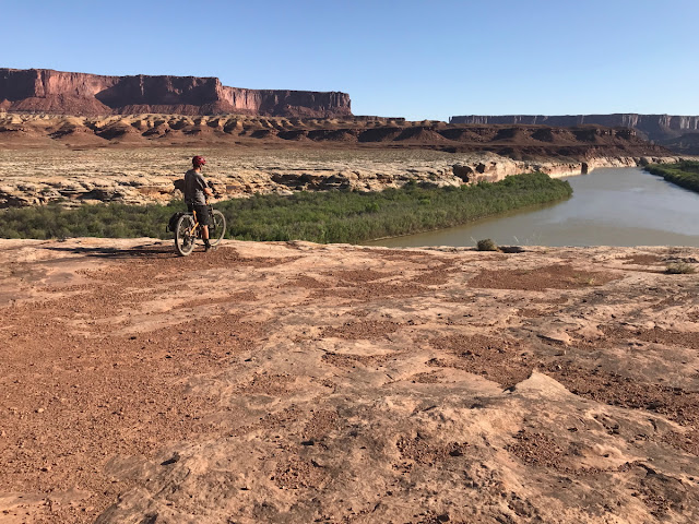 Trending north, the layers begin to descend in that direction and the White Rim Sandstone is shown here before it dips beneath the Green River. This gently north dip to the strata marks the northern limit of the Monument Upwarp, named for Monument Valley much father south. Beyond the far cliff here, Cretaceous strata are exposed in the Book Cliffs. They were last seen to the south at Black Mesa, Arizona. The Monument Upwarp provides the uplift that helps make Canyonlands such a superb geologic paradise.
 Ascending Hardscrabble Mesa, another Chinle-inspired climb that is white-knuckle. We saw a few folks on motorcycles on the trail who were definitely out of their element.
  A beautiful view to the north at the top off Hardscrabble Mesa. The Green River flows toward the photographer.


