Wednesday, October 26, 2022

The Montevideo Inscription in Grand Canyon

On November 30, 2010, I posted a piece about an inscription found near the South Bass Trail in Grand Canyon. It is in a neatly ornamented style with the word "Montevideo." You can view that posting here and the story that goes with it. A few days later, I posted an addendum and that can be viewed here.

Recently, a friend of my wife visited the site and literally stumbled onto another adjacent inscription that shows the year 1896. While this does not prove that the Montevideo inscription was left in the Wm. Wallace Bass era at Grand Canyon, it does show that Bass was leading people to this site at that time. I think the nearby inscription lends credence to the idea that Montevideo is more recent than the 1540s and from a member of he Cardenas party. The photos above and below are courtesy of Larry Kinser.


Sunday, October 16, 2022

An Autumn Hike in the San Juan Volcanic Field, Colorado

In early October, Helen and I journeyed to southwest Colorado and the San Juan Mountains near Ouray. We embarked on a five-day, four-night backpack along the Dallas Trail, traveling hut to hut. Thus, we carried no sleeping bags or tents to make the load lighter. The fall colors were at their peak and admittedly, this post is more about autumn than the San Juan Volcanic Field.

We had a group of seven and this is near the start of the hike.

Some of the route was along old logging roads.

This is our first hut, called North Pole hut. One of the peaks near here is called North Pole Peak. If you would like to know more about the hut experience you can view San Juan Huts here.

Each hut comes with a separate outhouse not far from the sleeping hut. These were very clean, modern, and well kept.

A view to the northeast toward the Cimarron Range of the San Juan Mountains. Ridgway Colorado sits in the valley of the Uncompahgre River in the valley below.

The Sneffels Range loomed large to our south as we made our way from west to east. An early season snow made the views dramatic against the changing aspens.

More Sneffels Range.

The average elevation of the hike was 10,000 and never deviated from between 11,000 and 9,500 feet.

A wild geranium also was in on the colorful show.

Most of the hike was through forests of aspen and conifer.

An early morning frost.

Finally, we reached Wilson Summit at 11,000 feet and were rewarded with a spectacular view!

Note the previously glaciated valleys in the distance as we took our lunch at the summit.

There was always a threat of rain during the five days (forecasted) but we managed to avoid precipitation.

In the Ridgway hut on night 3 planning the next days route.

An especially beautiful section of trail on day 4.

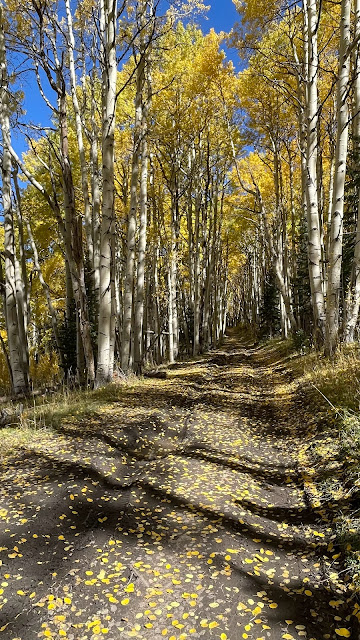
Aspens, aspens everywhere.

Burn Hut, our fourth and last hut.

Near Burn Hut.

Roots and aspen leaves vie for sunlight.

Approaching our final descent into the Uncompahgre Valley.

Across the way, the San Juan volcanics sit atop a basement of Paleozoic sedimentary rocks. We saw mining shacks at the contact of the two rock types.

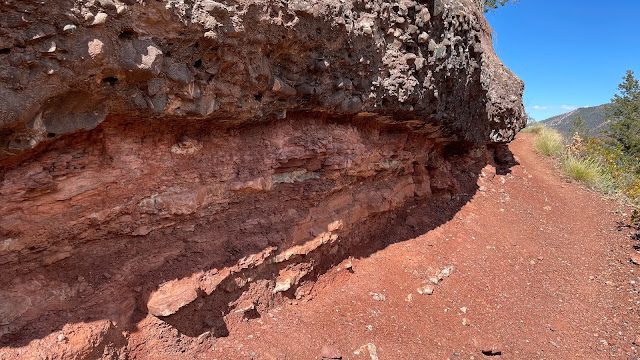
Colorful descent - this time in. rocks!

As we descended below the San Juan volcanic rocks, the basement was composed of the Cutler Formation, a Pennsylvanian sandstone, shale and conglomerate that was shed off of the Ancestral Rocky Mountains.

A channel of very coarse conglomerate is set within floodplain mudstone and shale. A very good trip with great people and fantastic weather!

Tuesday, August 30, 2022

From the Erzgebirge to Potosi

I heard from Sean Daly, a mining geologist and author who has published a book called, "From the Erzgebirge to Potosi". He has written a poem that rests inside the front pages of the book and I include that poem here for your reading pleasure. The book looks very interesting for those who may want to better understand the development of mining and its boon to the development of society and civilization. You can visit his personal website here.


Wednesday, August 17, 2022

Meteor Crater Like You've Never Seen It Before

Ejected and overturned Kaibab Formation sitting atop the younger Moenkopi Formation on the rim of
Meteor Crater. The sudden and violent impact peeled these layers backwards out of the impact site.

Northern Arizona is rich in geologic features including the Grand Canyon, the San Francisco Mountain composite volcano, Monument Valley, the Petrified Forest and Oak Creek Canyon. One other attraction that qualifies for this list is Meteor Crater, where a space rock the diameter of a football field slammed into the Earth's crust around 50,000 years ago. It excavated a hole 600 feet deep into the otherwise flat Coconino Plateau.

I have written on this blog about exclusive trips to the crater I have made previously. In 2010, I descended to the floor of the crater (not open to the public) with friend Drew Barringer, whose grandfather bought the property after determining that it was an impact crater. You can view the images and the post here, one of the most viewed posts I have written. And in 2015, I circumambulated the rim of the crater with the geology alumni of Northern Arizona University. See the images, graphics and geologic map and cross-sections of the crater in this post. Both posts are very instructive in understanding the magnificent preservation of this young impact crater.

Panorama of Meteor Crater looking to the south

Now, you too can visit Meteor Crater and hike around its entire rim with a geologic expert on impact craters! The Museum of Northern Arizona's Venture Program is offering a one day trip to the crater on Sunday September 18 from 9 AM to Noon. Participants  traverse the rim trail with a scientist who knows it intimately. This trail is approximately 2.5 miles long and is not generally open to the public.

The trip will be led by Dr. David Kring, a world-renowned geologist with NASA who trains astronauts in geologic studies. The link to sign-up for this trip can be accessed here. Admission to Meteor Crater is included in the trip price.

trip description is here:

Sunday, September 18, 2022 from 9:00 AM to Noon

Join geologist Dr. David Kring on an up-close tour of the World's best preserved asteroid impact site, Meteor Crater.

Participants will get an unusually intimate tour of the impact site by one of its leading geologists. From several locations around the rim, guests will learn of early exploration efforts, the evidence that the creator was produced by a near-Earth astroid impact, the tremendous explosive energy of that cosmic impact, and how it has forced seemingly immovable rock to flow, nearly instantaneously, to excavate an extraordinary geological site.

The trip will be led by Dr. Kring, who has been conducting research and leading training activities for NASA astronauts at the crater for about 30 years. He is also one of the well-known discoverers of the Chicxulub impact crater in Mexico, which he and others linked to the extinction of dinosaurs 66 million years ago.

The hike will be on the exposed rim of the crater and last approximately 2.5 hours. Please wear sturdy hiking shoes, wear sun protection, and bring water. Guess we'll be able to visit the Barringer Space Museum and bistro following the hiking tour. Participants will drive themselves to Meteor Crater. Please park in the lower lot labeled "Mars" and meet at 9 AM in the upper lot, near the building entrance.

Meteor Crater is located approximately 35 minutes east of Flagstaff, off of I-40 east exit 233.

If you live anywhere near northern Arizona, don't miss this trip! An incredible opportunity awaits.


The rim trail at Meteor Crater is not generally open to the public and gives a wonderful perspective
of the impact site. And going with an expert is a never to be forgotten experience
.


Wednesday, August 03, 2022

Descending Into the Throat of a Young Iceland Cinder Cone

Screen capture the new fissure eruption taken August 3, 5:58 PM local Iceland time

With news this morning of renewed fissure eruptions in Geldingadalir Iceland, I thought it would be fun and instructive to share photos and descriptions of a unique trip I recently completed in Iceland. On the trip from July 7-17 I served as a geologic lecturer and interpreter for Smithsonian Journey's. Imagine my disappointment at missing this new activity by only a little more that two weeks. (I may go back). A live feed of the new eruption can be viewed here.

The Ericsjökull ice cap on the Ring Road to Reykjavik

After touring the island with our Smithsonian guests for nine days, I had a free day while in the capital city of Reykjavik. A chance opportunity to go on a local tour known as "Inside the Volcano" popped up for me. I jumped on it! This is an excursion a short drive out of Reykjavik where visitors descend about 150 meters through a narrow vent into an extinct cinder cone. Of course, I said yes to the opportunity.

Preparing for the short walk

After the 45-minute drive out of the city and toward an upland area, visitors are brought to a waiting room where they receive instructions and rain gear. 

Cross-section of the volcanic neck (depths in meters) with the Statue of Liberty for scale

I was impressed with the signage inside the waiting room, which graphically explained the age, composition, and eruptive history of the volcano. A great resource for folks to understand the deeper story of the "thrill descent."

The trail to â±£rínúkagígur, two miles one way 

The cone is called â±£rínúkagígur (â±£rínúka Crater) and it was formed about 4,500 years ago in a post-glacial eruption. Iceland classifies its younger volcanoes as glacial or post-glacial. â±£rínúkagígur is one of three closely-spaced scoria cones (also called cinder or tephra cones) erupted along part of Iceland's southwest rift, part of the Brennisteinsfjöll (Sulphur Mountain) rift.

The opening at the top of the cone

Finally, we arrived at the opening to the volcano. The site was discovered and initially explored only about 20 years ago. Numerous studies were made to determine the advisability and safety of developing the site for visitors. The main concern was that in most scoria cone eruptions, the removal of magma in the terminal phase of an eruption causes the crest of the newly formed cone to collapse into a crater. It was determined that this cone did not collapse due to its relatively small size. The cavity that we would descend is bell-shaped.

Looking down after entering the cable car

The descent takes about seven minutes. The cable car has rubber "runners" on its sides as it comes quite close to the walls. There is just enough room.

On the floor of the volcano looking up to the surface opening 

On the way down we viewed multiple dikes that were feeding the surface lava eruptions. In the photo above, note the linear dike trending upwards toward the opening and a subsidiary dike above the person with with the purple jacket.

Another party descending to the floor of the volcano

The feature is well-visited and is well-organized for visitors. Three separate parties of about seven people each are rotated through the inside the volcano and cable car at any one time. 

The trail marking the path on the volcano floor

A loop trail over very coarse rubble can be made. This is not for the faint of heart - the lighting is low, the trail very rough and water constantly drips down from the roof making things slippery.

Note the person in white for scale

The temperature is quite cold at about 38º F and many people found gloves useful on the trip. After 4500 years, the inside of the volcano has cooled sufficiently.

Dike swarm in the walls of the volcano 

The colors are due to the various states of oxidation adjacent to the dikes in the walls.

Lavacicles form on the walls 

This was a very unique trip. It is somewhat expensive being about $300 US per person. But it does include excellent and geologically literate guides, a bowl of hot, Icelandic meat soup in their kitchen near the volcano, hot tea and coffee, and heaps of fresh Icelandic air (and likely rain). See their website for more information here.

Wednesday, July 20, 2022

A Review of "Unconformity" - A New Indie Film Featuring an Impressive Geology Theme

As a geologic educator who has been around since the latter quarter of the 20th Century (read 'ancient'), I occasionally receive requests to review books, articles and now, films, that contain geologic themes. On July 11 of this year, I received an email asking if I would be interested in watching a new film and writing a review on this blog. I was skeptical at first but then I watched the film's opening and was hooked. That's what I call a good opening (described below). FYI - I am receiving no compensation of any kind in making this review.

Now I do not claim to be any kind of a bonafide film critic and I have virtually no idea what to look for in reviewing a film. My wife is much more talented than I in seeing beyond the mere visuals of a film. I typically need every ounce of my energy just to keep up with the storyline and often need to ask her, 'which character is that'? (Let's not even discuss the plot or who is likely the villain in a "who dun it" film). 

Still, when Director Jonathan DiMaio allowed me to view his film, I found myself taken in by the story. I'm sure the primary reason is because of its geologic theme. Second perhaps is the side-story of public lands issues and the ways rural ranchers relate to the Bureau of Land Management. Third is because of the great acting that Alex Oliver presented, depicting a young PhD candidate struggling with issues of identity, purpose, and some of the darker aspects of academia. 

Actress Alex Oliver examines the Ediacaran fossil Dickinsonia after discovering it in Nevada. Director Jonathan DiMaio used this fossil, to date only found in Australia, to depict an original scientific discovery in the plot of the film.

The trailer for the film can be viewed here and gives just a few hints of the Basin and Range scenery that I felt could have been used more prominently in the full-length feature (I'm a sucker for landscapes depicted in film). One of the scenes shows a close-up of what I believe is the Ordovician Eureka Quartzite. Another is of a beautiful, tilted stack of central Nevada limestone. I would have loved to see more of that imagery sprinkled throughout the film but it is nonetheless there in short clips. Early Paleozoic limestone anyone?

What initially drew me into the film was the opening credits where thin sections are shown rotating in cross-polarized light. Anyone who has ever taken an optical mineralogy class will view these opening scenes with remembrances of those fantastic, shifting colors. Non-geologists may be confused about what that imagery represents, but it is colorful and I found it mesmerizing. I was hooked from these scenes forward.

Which makes me wonder, will those who are not geoscientists be attracted to the film? There is a human story that is at the heart of the film that I would summarize as youth trying to find their way in a confusing world. Maybe there is some appeal to the film in that aspect. I was swept away in the film by the geologic theme, used as a backdrop to this human drama. If you do watch the film, and I recommend that you do for a mere $3 on Amazon, please let me know what you think.

As of now, the movie is available to rent in the US. You can find it on Amazon. Toward the end of the year, it will be available worldwide (except for a few autocracies) on various platforms, some of which are "free" and ad driven. 

When was the last time the Neoproterozoic was featured in an American film? Let's go to the movies!

Saturday, May 07, 2022

Private Jet Adventure Over the American Southwest

The story and video that was posted here yesterday has moved to my personal blog site, All In A Day's Karma. Google changed some functions on its platform and I am still learning to navigate the changes. Sorry for any confusion. However...

It's been awhile since I posted something here. I've been busy on lot's of trips. One was a Private Jet adventure over parts of the American Southwest. Here are a few photos from the trip.

The Sonoma California coast

Mono Lake California 

Frenchman Mountain Nevada

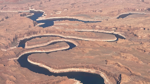
Where the San Juan river (bottom) meets the Colorado River (top) now under the Powell reservoir, looking west


The Salt Valley Utah


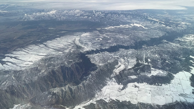
Grand Mesa Colorado


The Black Canyon of the Gunnison River Colorado


Charcoal kilns, Ted Turner's Rancho Vermejo New Mexico


Sangre de Cristo Mountains, Ted Turner's Rancho Vermejo New Mexico