Friday, June 21, 2013

An Eight-Day Colorado River Trip Through Grand Canyon - Part 3

The last part of this narrative involves traversing the Upper and Middle Granite Gorges. Grand Canyon has three inner gorges named Upper, Middle and Lower. These are where some of the best rapids are located as well as some of the best rocks.

A view of the Upper Granite Gorge above the Phantom Ranch area.

Near river mile 83 on the left is a small body of ultramafic rocks. These are rocks that were originally located in the earth's mantle but found their way to the surface in rare circumstances such as when a spreading center is obducted onto the edge of a continent. THis likely hasppened in the Grand Canyon region some 1,750 million years ago.

These pods of the ultramafics are found within the Vishnu Schist, a crustal rock that formed when 13 miles of overlying material covered the area. These rocks used to be sandstone and shale but where deeply buried and altered.

A close-up of the ultramafic rocks in Grand Canyon, with xenoliths of quartz from the Zoraster Granite included.

Here comes the second boat through upper Horn Creek Rapid.

The second boat running through lower Horn Creek Rapid. With such hot temperatures it was a thrill to ride the rapids. The volume we had on this trip varied between 11,000 and 17,000 cubic feet per second, an excellent level to run.

Some of the gneissic banding seen on a side hike in Trinity Canyon. The folding in these rocks shows how deeply buried and ductile they were during formation.

On the way to Bass Camp, our fourth on the trip.

The view upstream from Bass Camp with crystalline rocks next to the river, tilted Supergroup rocks in the middle, and flat-lying Paleozoic rocks on top.

Gerry is in love with deformed rocks. How do I know? It's the grin that gives it away. These beautifully massaged rocks were found in the gorge of Shinumo Creek where we enjoyed a swim beneath the waterfall shown below.

Shinumo Creek waterfall.

The reflection pool in Blacktail Canyon.

Strata in the Grand Canyon are not entirely flat-lying. Just 50 miles upstream the ledgy Tapeats Sandstone seen here at river level was 1,200 feet above the river. These strata are gently warped such that a trip down the river provides a lot of variety in scenery.

Entering the Middle Granite Gorge. The jet black rocks are metamorphic basalt lava flows.

Unconformity where the Bass Limestone above rests on the crystalline rocks of the Inner Gorge. Imagine this erosion surface formed some 1,255 million years ago. At that time the erosion surface was more flat-lying. Then limestone was laid down on top of and buried the surface. Later tilted put it at the angle seen in the photograph.

Self-portrait at Deer Creek.

Deer Creek waterfalls and gorge.

My camera battery died out after this picture was taken only half way through the canyon. Here we are pushing a large heavy boat off of the shore. This was an excellent trip with a great group of people, lots of geology, and fun times. Thanks for reading.

Thursday, June 20, 2013

An Eight-Day Colorado River Trip Through Grand Canyon - Part 2

A continuation of the photo's from my recent rafting trip in Grand Canyon with Professional geologists.

Morning breakfast to fuel up for a hike in the summer heat.

Making lunches for the hike at 6 AM!

Approaching the confluence of the Little Colorado River at river mile 62. Cape Solitude towers over the confluence some 4,000 feet above our raft.

Dissolved calcium from the Redwall Limestone makes the Little Colorado River a turquoise blue color as light refracts off of the dissolved solutions. The water is warm and inviting for a swim.

At about 2 PM, our hike begins up Carbon Canyon. We have wet all of our clothes and hats and this helps to keep us cool. We have also put extra water in Ziplock bags so that when our shirts dry out, we can rewet them in the bags. Ingenious! After climbing around a huge rockfall in the canyon floor, we look back and see a thrust fault in the wall of the canyon. You will notice two thin beds just below the center of the photograph, then see them thrust over along a low angle line that run upwards from right to left. This is the thrust plane, which is likely an antethetic fault to the larger structure we still have yet to see.

Our group hiking in the slot canyon after the picnic lunch and approaching the Butte Fault.

Shown is the Tapeats Sandstone as the originally flat layers are dragged upwards along the trace of the Butte Fault (off the picture to the left). We had an interesting group discussion here about how some young earth creationists view this as evidence that the layers were soft (and thus young) and easily bent. Hmm? Is that the only possibility for how this formed? Or might there be a pre-determined outcome needed (and not related at all to geology) to fit another religious model? The answer is that when these rocks were deformed, they were at depth and ductile. Later erosion removed thousands of feet of overlying strata that then exposed what is seen here.

Geologist Lisa Greer looks at giant mud cracks in the Jupiter Member of the Galeros Formation. These rocks are part of a NeoProterozoic (about 800 million years old) package that is rare in the American Southwest.

The colorful beds of the Carbon Creek Member of the Galeros Formation.

At the end of the hike we retuned to the Colorado River at Lava Chuar Rapid.  Across the river are basalt rocks of the Cardenas Lavas, erupted about 1 billion years ago on a coastal floodplain.

A Scar In The Earth's Skin

My friend Toni Kaus took this picture north of San Francisco where the trace of the San Andreas Fault can be seen in the valley floor, Here the fault heads offshore beneath the waters of the Pacific Ocean. I was moved to write a sort of Haiku about it.


A giant scar in the Earth's skin! 
The cool breezes of northern California assuage the pain 
But the scar is not yet done 
The land on the seaside will one day collide with Alaska 
Moving Earth Moves me.

Wednesday, June 19, 2013

An Eight-Day Colorado River Trip Through Grand Canyon - Part 1

I just returned from an eight-day Colorado River trip in Grand Canyon with other professional geologists. The trip was organized by my friend and colleague Howard Capito who assembled these professionals, friends, and family members. One of the striking facts about this group was the high number of participants who had never before seen Grand Canyon - their first views would be from the bottom up. The trip was successful beyond any measure. And it was fun!

Of course, a river trip of such length needs supplies. Here in the hold of our bus is enough liquid refreshment to ward off the hot summer temperatures.

The put-in at Lees Ferry after the four and a half hour drive from Las Vegas. While some folks might consider such a trip something to put behind them, our group relished the idea of driving from the Basin and Range Province to the boundary with the Colorado Plateau, and then climbing onto its red rock heart. Yeah baby!

Our first nights camp was at North Canyon, 20 miles below Lees Ferry. Here is a partial assemble of some of the distinguished geologists on the trip. From left they are Dr. Ron Blakey, co-author with myself of "Ancient Landscapes of the Colorado Plateau," Dr. Ed Spencer, retired geologist and educator at Washington and Lee University in Lexington, VA, Howard Capito, passionate geology fan from Knoxville Tennessee and former student of Dr. Spencer, Wayne Ranney, and Dr. John Warme, retired professor from the Colorado School of Mines. There were other geologists along whom you'll meet further down.

On our first hike up into North Canyon, geologist Gerry Stirewalt observes an outcrop in the Supai Group, specifically a river channel filled with conglomerate. You can see the channel as the concave up feature in the center of the photo.

Beautifully sculpted walls in North Canyon shows evidence for exfoliation in massive (unbedded) sandstone. Since the exfoliated planes are parallel to the shape of the canyon walls, it is likely that the exfoliation formed as rocks were eroded out of the canyon, releasing the load pressure that once confined the rocks.

Our second stop was new to me - a fossil-rich ledge in the Redwall Limestone section of Marble Canyon. Here is a nicely preserved rugose (or horn) coral with branching corals nest to it.

Another well preserved coral at the site, located at river mile 24.5.

John Warme explaining the formation of chert nodules in the Redwall at the same fossil site.

Rapid 24.5 Mile.

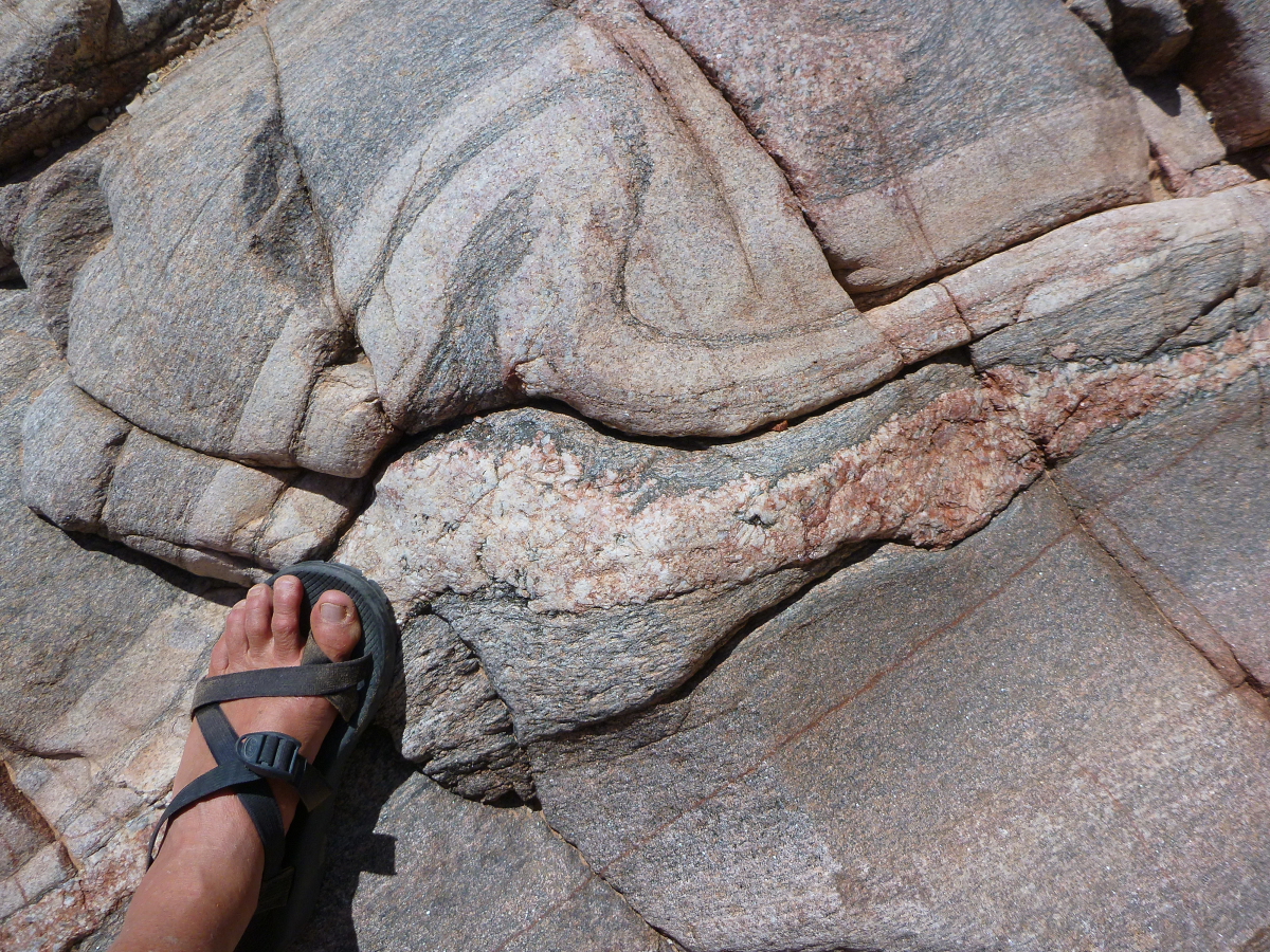
The last stop on this second day was to view in detail some of the Devonian-age channels cut into the Muav Limestone. Here is an excellent view of a channel about River Mile 39.

The older Muav Limestone is the light colored rock on the right. It is approximately 125 million years older that the purple layer on the left, called the Temple Butte Limestone. Before Temple Butte deposition, a channel was cut into the Muav and then filled with the purple sediment.

Admiring more channel-forms and some root casts in the Tempe Butte Limestone.

John Warme thinks the vertical burrows shown beneath the topmost visible bed might be lungfish burrows. AN expert in such matters will travel with him to this site on his river trip in September.

Part II follows this in the next post.

Thursday, June 06, 2013

"Carving Grand Canyon" Wins Design Award with PubWest

On June 5, 2013, the 2nd edition of "Carving Grand Canyon" won a Bronze award (third place) with the trade organization PubWest for superior design in the category of Academic/Non-Trade. The awards were announced yesterday and you can view the winners in each category here.

Here is a listing of the award winners in the category of Academic/Non-Trade:
  • "Atomic Comics: Cartoonist Confront the Nuclear World"  University of Nevada Press (Gold winner)
  • "The Menial Art of Cooking" University Press of Colorado (Silver winner)
  • "Carving Grand Canyon: Evidence, Theories, and Mystery" 2nd Edition Grand Canyon Association (Bronze winner) 
I would like to give a special big thanks to Jami Spittler who designed the book, Faith Marcovecchio, the project manager, Bronze Black who rendered many of the drawing and maps, and Pam Frazier who helped with the copy edit and text. "Carving Grand Canyon" continues to sell well and to educate people about the many theories for how the Grand Canyon formed.

The Colorado River looking upstream from near Deer Creek at River Mile 137 (Photo by Wayne Ranney)


Here is a copy of the official award letter from PubWest