For the second time in three years, the Northern Arizona University Geology Department sponsored an alumni river trip in the Grand Canyon. I was honored to be asked to be one of the instructors on this trip. Anyone who has obtained a geology degree from NAU knows how special the program is and these trips serve as a way to keep alumni connected to the program long after they have graduated. On this trip, we had people ranging in age from their 20s to their 70s, as well as alumni who graduated in the 1970s to the 2010s.
The morning of August 9 saw us gather for a one day field trip (ahead of the river trip) to the Lees Ferry area. Here Cathy Noll, John Noll, George Billingsley, Paul Umhoefer and Norman Kent gather in the parking lot at the Geology Building.
Short introductions were made as we enjoyed breakfast and George Billingsley gave us an overview of the canyons geologic setting. Billingsley is well-known in the region as he mapped the entire Grand Canyon region during a 40+ year career with the USGS in Flagstaff. He did this by compiling nine 30 minute X60 minute geologic maps. This equals about 1568 square miles per map, meaning that Billingsley mapped 14,112 square miles in northwest Arizona! Billingsley was the second person to obtain a Masters Degree in geology from NAU in the early 1970s. Dr. Paul Umhoefer looks on from the corner.

We were able to visit Desert View on our field trip and see the Colorado River that we would soon have the pleasure of traversing. Below the rim (photo center) the river trends toward the photographer after leaving the confluence with the Little Colorado River. The large black massif seen to the left of the river (yes, it is large as it just appears small within the Grand Canyon) is composed of the Cardenas Lava and while on the river trip we made a 4.5-mile hike around that block of rock (photos below). Note the monsoon storm in the distance. This would prove to be the only day of rain for the entire nine-day trip.
On the way, we also detoured to the road that climbs the Echo Cliffs...
Echo Cliffs...Echo Cliffs. They are visible on the far left. Later on our river trip, we caught up with an oar trip in which I knew most of the boatmen and when I asked them if they had any rain, they said, "Only in the lower part of Marble Canyon." A quick calculation of what day that was, revealed that the storm pictured here in the distance is the very storm they were drenched in. Our trip was dry, dry, dry and very hot!
One of the benefits of staying close to the put-in is that you can arrive at Lees Ferry in time for a hike. We visited Lees Lookout where we could look to the southwest and see the huge delta of the Paria River (photo center) pushing the Colorado River up against the far left wall. Next to the river the red Moenkopi Formation (Triassic) appears and is capped by the tan Shinarump Conglomerate Member of the Chinle Formation.
Swinging around to the right from Lees Lookout, we see the Vermilion Cliffs rising above the Lees Ferry parking lot. It is curious to note that even though this will be a Grand Canyon river trip, none of those rocks can be seen yet - they remain in the subsurface here. Above the parking lot in the photo center note the terrace where the water tower and campground are located. This is a terrace remnant from a former time when the river had not incised to its present depth.
Note: This post is not a comprehensive look at all that we saw on this trip - I have only shown a few of the many gems that we experienced. For the record, we hiked at Jackass Canyon (Coconino Sandstone reptile trackway) North Canyon, Twenty-four-and-a-Half Mile (fossils), Redwall Cavern (where we were treated to a concert by the
Skylight City String Quartet), Saddle Canyon, Carbon Creek Loop, Seventy-five Mile Canyon (soft sediment deformation), Shinumo Creek, Elves Chasm, Blacktail Canyon (The Great Unconformity), Deer Creek, Havasu Creek and Pumpkin Springs.
This is a boulder on the beach at Carbon Creek. But it is not just any kind of boulder.
It is a fossil of a primitive algae that grew on the sea floor some 750 million years ago. The photo is arranged such that the fossil is in its growth position. These are cauliflower-shaped masses of algae are called
stromatolites. Here you can note the concave-up growth structure with darker fine-grained sediment infilling the interstices.
This is a view of another boulder showing what the stromatolite would look like if you were snorkeling on top of it.
This is a photo of yet another boulder with a side view into the interior of the algae colony. In this example the fine-grained sediment is eroded out to reveal the individual columns of algae growth. The species is called
Boxonia.
From this beach, we began a 4.5 mile loop hike.
On the way up Carbon Creek Canyon, we could see the coarse nature of the Tapeats Sandstone. It's like a cemented grit with lots of potassium feldspar (pink grains). These of course are eroded from the underlying Zoroaster Granite. However, the Zoroaster is not present here in this part of the canyon? This means that the grains were likely washed here from farther east, where the terrestrial uplands would have been located are this time.
After climbing around an obstacle in the streamed (a pour off), we attained a great view back down the canyon and noticed something odd in the strata - a thrust fault. What is a thrust fault doing here?
This is the same photograph but I have outlined the thrust fault (yellow line) in the photo. The two red lines depict a contact offset by the fault. Thrust faults are not common in the Grand Canyon but this one formed as a result of compression along the Butte fault, located about 1/2 mile behind the photographer. As that master fault squeezed the crust the upper block here was pushed to the east.
This is the view on the opposite wall. It appears that the shortening of the crust was accommodated by slippage along shale beds in the Dox Sandstone.
Here is the same photo but with yellow lines depicting where strata have been broken. All of this breakage occurred while this area was still buried under at least 4,000 feet of rock, likely more. It occurred during the Laramide orogeny between about 70 and 40 Ma.
Further along the trail, we enjoyed the cool shade of the upper slot canyon. We were now in a gorge of flat-lying Tapeats Sandstone.
But not for long! As we emerge from the slot canyon, the beds are sharply folded...
...and project upwards into the sky. This is the area of the Butte fault and the East Kaibab monocline.
The beds are near vertical with about 2500 feet of vertical uplift to the west of here.
The fault has raised the Chuar Group of rocks into a position where they can be eroded. Since these are composed of soft shale and mudstone, Carbon Creek has no problem eroding them into a huge wide valley, with great views of Grand Canyon's North Rim in the distance. What a difference a fault makes! We were previously hiking within hard, difficult-to-erode sandstone that formed the slot canyon and in a matter of a few meters we were in much softer rocks that revealed an open valley.
As we followed the fault for about one mile to the south, we encountered micro-structures such as this small offset with slickensides, that revealed the sense of motion - vertical.
Upturned and eroded beds of the Chuar Group revealed ancient mud cracks and perhaps large ripple marks on the bedding planes.
As we made our way back to the river in Lava Chuar Creek, we were back into the Dox Sandstone where we observed salt crystal casts (squares). The Dox is interpreted as a coastal floodplain deposit and the nearby seawater likely was the source of the salt casts, about 1110 million years old.
The modern stream has left these cobbles on top of the Dox Sandstone. Thus, this is an unconformity nearly as large as where the Great Unconformity. Note the preferred orientation of the cobbles that reveals which way the water was moving - from left to right in this view. This is called imbrication and can used in ancient deposits to infer stream flow direction.
 |
| Brent Voorhies photo |
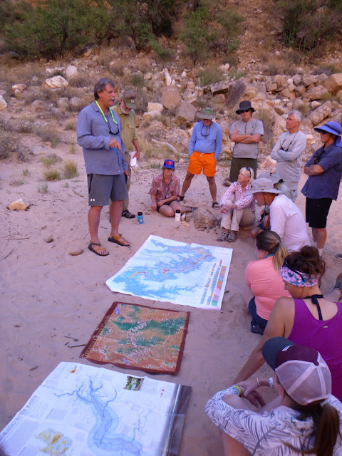
Each morning myself and the two NAU professors would talk about the days' upcoming geology delights. I always lay out the geologic map of the Grand Canyon as well as other visuals. These are important parts of the program as we begin another days exploration.
A typical evening camp scene. This location is called Schist Camp and it was our fourth night. We were deep within the Upper Granite Gorge near river mile 98.
Relaxing next to the river on a hot night is a joy, especially with cold beverage.
We did experience a couple of days of intense smoke from wildfires on the North Rim. The photo doesn't really capture the mood it set.
At the Great Unconformity in Blacktail Canyon, I explained the history that is missing from such a contact. The schist below is about 1,750 million years old and the sandstone above it is "only" 500 million years old. The gap in the rock record equals 1,250 million years.


