I recently fulfilled a long-time desire to visit Oklahoma. For many years, I joked that "
Oklahoma is the closest place I've never been to." No more. I honestly believe that there is something to see everywhere, even geologically. So after landing in Oklahoma City's Will Rogers World Airport, I headed southwest in a rental car to see the Wichita Mountains. Of course, I would find some very interesting things to see along the way toward the mountains. First stop - Fort Sill. (Hint to the geologists - the description of the geology of the area begins about half-way through the post).
My first view of the Wichita Mountains from the Will Roger's Turnpike and Interstate 44.
The route passes through many different Native lands and the Comanches have always loomed large in my consciousness. Truly, the Lords of the Plains!
I stopped to ask directions and inside the Gaming Office I saw this interesting painting that depicts the Comanches in their prime.
I obtained a day permit to enter the Fort Sill Military Reservation.
Fort Sill is where the Arizona and New Mexico Apache prisoners of war were compelled to live out the rest of their lives. Geronimo made his final surrender in
Skeleton Canyon in the Pinaleño Mountains in extreme southeast Arizona in 1886 and was shipped along with many others to Fort Pickens in Florida. After eight years there, they were removed to Fort Sill in 1894.
Some of the original picket houses still stand at Fort Sill, this one constructed in the 1870s.
The west side of the Fort's parade grounds is located along Geronimo Road.
And of course, my purpose in going to Fort Sill was to visit the gravesite of the leader of the Bedonkohe (Chiricahua) band of Apache warriors. This has been a long-time dream of mine since I partook in the Centennial activities of Geronimo's final surrender in 1986 in Cochise County.
Sign at the entrance to the cemetery along Beef Creek on Fort Sill.
Here it is - Geronimo's grave! Unfortunately, the eagle head has been broken off and there seems to be no indication that it will be repaired. Coins litter the ground at the foot of the pedestal.
Close-up of Geronimo's name on the pedestal.
A wider view of the gravesite location. The view is to the northwest and Beef Creek is behind the photographer. All of the graves are of Apache warriors or their families.
Geronimo's daughter is buried nearby. The date indicates that she was born at Fort Pickens in Florida and died two years after her father did in 1909. The following shots are of various Apaches interred in the cemetery.
La-Zi-Yah
Fenton Geronimo
Dohn-Zay (LuLu Geronimo)
Dah-Ke-Ya
Chief Loco
I brought a rock from Arizona to place on Geronimo's grave. I had heard that Geronimo made many pleas with the government to return to his homeland but all requests were denied. To this day, there is still sentiment among some Arizona and New Mexico Apaches to return his remains to Arizona. But people in Oklahoma are resistant to the idea. I thought it would be a nice gesture to bring a piece of Arizona here.
The rock on the grave.
A sign as you leave the cemetery. I too have been a proponent of returning Geronimo's remains to his beloved Southwest. But I must admit that after visiting this cemetery, that is not such an easy thing to do. Here he rests with 300 other Apaches and to remove one from the many is probably not right. This is perhaps why the calls for the return of his remains have not been more pronounced. It was a moving and heartfelt visit and if you love Arizona or Southwest history, a stop here is a must.
On to the Wichita Mountains and its geology!
Location map of the Wichita Mountains in Oklahoma. Geronimo's grave is located on the far right of the map about where Highway sign 277 is shown. Locations I visited are Medicine Park, Mt. Scott and Meers, located in the right quarter of the map. Photos included in this post are of the Wichita Granite, Limestone group, and Permian Redbeds (from Gilbert, M.C., 2014, Oklahoma Geological Survey, Guidebook 39).
This is the little community of Medicine Park nestled in the Wichita Mountains.
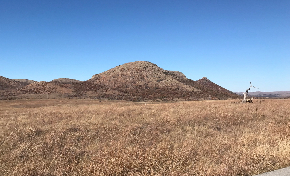
Mt. Scott is composed of the Wichita Granite, an Early Cambrian intrusive suite. It is important to remember however, that the form or shape of the Wichita Mountains is Permian and was preserved under Mesozoic and Cenozoic cover for most of its existence. This is an exhumed Permian landscape.
Map of the igneous rocks of the Wichita Mountains (from Gilbert, M.C., 2014, Oklahoma Geological Survey, Guidebook 39).
The mountains are part of the
Wichita Mountains National Wildlife Refuge with many bison and pronghorn on the refuge (which I did not see).
This photo is used from Gilbert, M.C., 2014, Oklahoma Geological Survey, Guidebook 39, and shows a Permian streambed (in the foreground) with tributaries trending away from the photographer. This stream is being exhumed from beneath the overlying Post Oak Conglomerate (Permian). Modern Medicine Creek is co-opting the Permian streambed (line of riparian trees in the foreground).
Cross-section through the range showing how the Permian units lap onto the igneous rocks.
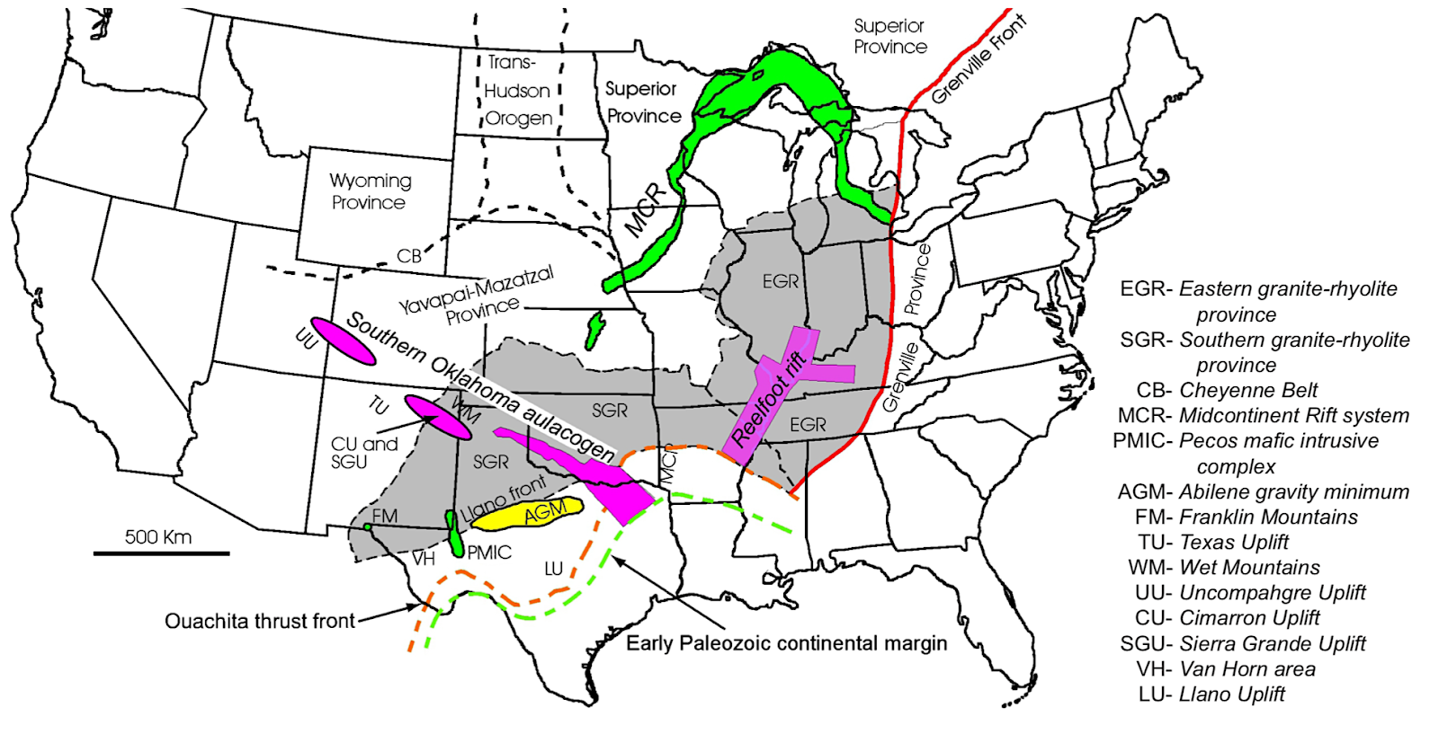
The Wichita Mountains are part of the Southern Oklahoma aulocogen (failed rift). For more information on this feature see
here. This trend of mountain building extends northwest and also includes the Uncompahgre Uplift in southwestern Colorado. In other words, this uplift was related to the Ancestral Rocky Mountains, so prominent in southwestern geologic history.
Structural setting of the Late Paleozoic basins in south central North America.
Imagine a
Dimetrodon walking and seeing this same mountain. Such animals were alive in this area at that time (about 260 Ma).
Another view of these Permian-age mountains driving north toward Meers.
This is Mt. Sheridan in the northern part of the Wichita Mountains.
I was given a hint that there was a famous restaurant (and not much else) in the small community of Meers.
It is a classic small town establishment that prides itself on serving Texas Longhorn burgers. They were good!
The inside of Meers Restaurant.
A last look to the south of the Wichita Mountains.
Driving north on State Highway 58, the landscape flattens out as the mountains are left behind.
This is the Ordovician McKenzie Hill Formation (limestone) that was buckled and deformed in the Wichita Mountains uplift, now exposed in roadcuts along State Highway 19 west of its junction with State Highway 58. A giant unconformity separates Ordovician and Permian rocks in this part of Oklahoma.
Redbeds of the Permian Rush Springs Formation made up a lot of the landscape west of Anadarko on State Highway 9. Who says Oklahoma doesn't have rocks? Only those who haven't been there! The Rush Springs Formation is approximately 300 feet thick with local bands of dolomite and gypsum.
An abandoned gas station on State Highway 9 just west of Anadarko.
These make for great photo studies.
I can guess the time at which the station might have become abandoned - ethyl gasoline was priced here at $0.49 per gallon. In Oklahoma, this means it might have been in the mid-70s. I remember being in shock at seeing the price of gasoline at $0.56 per gallon in Tuolomne Meadows in the High Sierra in 1973.
This was a fantastic day! To see images of Oklahoma City and the lecture I gave there, go to my personal blog at
http://all-in-a-days-karma.blogspot.com.