Saturday, August 21, 2021

Popular Articles and a Scientific Paper About The Great Unconformity in Grand Canyon

If you've been on the internet recently, you've probably run into a newsfeed about research done on The Great Unconformity in the Grand Canyon. Popular articles can be found in The Daily Mail (UK), Forbes  Magazine (US), and many other outlets that have picked up on the juicy theme (anything about the Grand Canyon always seem to sell to publishers). 

The Great Unconformity seen along the Tonto Trail looking at Hermit Rapid.
The dark brown Tapeats Sandstone sits on top of the grey Vishnu Basement rocks.
The Grand Canyon Supergroup was completely eroded away at this location before the
Tapeats was deposited but is found east and west of this location.

I've received numerous queries about the substance of the scientific study, titled Zircon (U-Th)/He thermochronology reveals pre-Great Unconformity paleotopography in the Grand Canyon region, USA. The paper was published in the journal Geology by the Geological Society of America. The lead author is Barra Peak with second author Dr. Rebecca Flowers (and two other colleagues, all from the University of Colorado, Boulder or the University of California Santa Barbara). 

The popular articles seem (to me) to have missed the main findings of the study. They use flashy-sounding keywords that have little to do with the substance of the study (themes around John Wesley Powell, Rodinia supercontinent, tectonic plates, and faulting). These are pieces of the story but very little is mentioned of the main results of the research and what that means to Grand Canyon geologists. 

I do not fault (pun intended) the authors of the popular articles for their lack of clarity or deeper understanding of the main thrust of the scientific study - this is a really complex topic. Still it might have been better if someone more attuned to the canyon's overall geology could have been called upon to write this article. Geology is a tough wall to climb. I am happy for the authors of the study to have had their research so widely and generously exposed and I don't want to diss anything that promotes geologic thinking! 

My purpose of this post is to explain more clearly to those interested what the study reported on. Short answer to those who know Grand Canyon geology - they said that the Grand Canyon Supergroup was not deposited in the western half of Grand Canyon. This is something that previously could not be known. An alternative idea is that the Supergroup rocks were deposited and present at one time across all of the Grand Canyon region, but were then eroded away in the western half before the Tapeats Sandstone washed over the entire region beginning about 508 Ma. This study would seem to eliminate that scenario.

Findings

Grand Canyon has three packages of rocks and this study involved the oldest two, the Vishnu Basement rocks and the Grand Canyon Supergroup, both packages located below The Great Unconformity. The third and youngest package, flat-lying Paleozoic rocks, lie immediately above The Great Unconformity. To learn everything you ever wanted to know about The Great Unconformity see Dr. Jack Share's posting on his geology blog, Written In Stone: Seen Through My Lens. His postings are here and here. For a more scientific description of The Great Unconformity, see Karlstrom and Timmons, 2012: Many unconformities make one 'Great Unconformity' in Grand Canyon Geology: Two Billion Years of Earth History.

Grand Canyon's three rock packages

I include below Figure 4 from the study. Four time slices are displayed, A) 1255 Ma; B) 1100 Ma; C) 800 Ma; and D) 510 Ma. The horizontal representation extends from eastern Grand Canyon (near the Little Colorado River) on the right side, to the Grand Wash Cliffs in the west and on the left. The pink color denotes the Vishnu Basement rocks, yellow denotes the Unkar Group (Lower Supergroup), and red is the Chuar Group (upper Supergroup). 

The scientists studied the cooling history of the rocks. When rocks are deeply buried they are hot but as erosion removes what lies over them (their cover), they become cooler and a technique has been developed that can "see" when the rocks progressively cooled. This is called thermochronology (literally temperature clock). The Vishnu Basement rocks in western Grand Canyon revealed to the authors of the science paper that they had not been deeply buried while he Supergroup was being deposited in the eastern half of the canyon. This could be explained by them never being deposited there. Note how the yellow and red is confined within a down-faulted basin. located between the Butte and Sinyala faults. Apparently, the Vishnu Basement rocks revealed that they were buried by the Supergroup in this area. 


The main message to Grand Canyon geologists is how restricted the lateral extent of the Supergroup was in Grand Canyon. I didn't sense this was fully explained in the popular articles. Granted, that might be too much of a pull to try to explain all of this in a popular article (i.e., "who cares?"). But to Grand Canyon geologists, this is significant.

I am not an expert at all in the methods and interpretation of the thermochronologic methods. However, an initial question I would have for the science authors is, can a mile-thick sequence of strata and volcanics (the Unkar Group) really abut a fault and completely pinch out against the Sinyala fault? Might that be more a function of the modern preservation of the Supergroup?  The authors are confident enough in the technique to publish their findings. Time will tell how others in the scientific community respond to this study. For the time being, it does provide something to think about.

ReferencesPeak, B.A., Flowers R.M., Macdonald, F.A.  and  Cottle J.M., 2021, Zircon (U-Th)/He thermochronology reveals pre-Great Unconformity paleotopography in the Grand Canyon region, USA: Geology, v. 49, https://doi.org/10.1130/G49116.1

Karlstrom and Timmons, 2012Many unconformities make one 'Great Unconformity' in Grand Canyon Geology: Two Billion Years of Earth History. GSA Volume 489.

Saturday, August 14, 2021

Final Thoughts on Leaving Iceland 2021

An Arctic tern. on fencepost in southwest Iceland

What a trip! We were not strictly limited to an itinerary made months in advance. We had a framework of stops but while on the ground, we often made on-the-spot decisions to 'turn here' or 'go there.'

There is turmoil in the USA about masks and vaccines. We felt very comforted in Iceland as 91% of the population over 16 years of age is fully vaccinated. Mask-wearing is non-contentious. Those numbers are based on medical criteria and not some contrived political point. 100% of all visitors are either fully vaccinated or recovered fully from the virus. Our largest exposure to the virus in all of our travels were the domestic flights we made in the USA. How odd is that for the richest country in the world.

The Arctic tern has the longest migration of any animal - 12,000 miles going from the Arctic to Argentina

Many have expressed to me a desire to go to Iceland. Be aware it is very expensive. And the weather is often rainy or cloudy or foggy. To the geologist, it is an unequalled laboratory of volcanism, glaciation, landslides, and catastrophism. Go!

I must also thank my two hosts and travel partners, John and Chris. They were wonderful companions and their enthusiasm for what we saw and experienced along the way pushed me to deliver more of the same. Thank you!

We made a few last stops at the southwest corner of the island. The geology was outstanding. Thank you for reading.

(Some have asked if we visited the volcano that is erupting. We did drive by the parking that has ben established and spoke with those who had hiked to it that day. Apparently, nothing was happening at that time. However, to read an excellent account of the eruption in The New Yorker Magazine, see here). 

The southwestern tip of the Reykjanes Peninsula. View to the southwest.

The peninsula is constructed along the mid-ocean rift and there is much geothermal activity. 

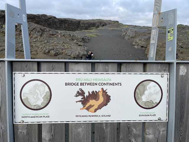
The sign at the Bridge Between Continents was an excellent geologic stop for us that was spontaneous.

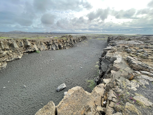
A view of the Bridge Between Continents with young pahoehoe lava textures in the foreground.

Sign on the Eurasian side of the bridge. I thought the text included was quite interesting - not necessarily geologic on the whole. I think this technique works well to help non-geologists stay engaged with the site and the larger geologic story that the bridge represents.

And the equivalent sign on the North American side. Again, the information displayed was thoughtful.

An excellent final shot from my July 25-August 5 trip to Iceland - a rifted valley as it extends away from the photographer and into the North Atlantic Ocean. Iceland rocks!

Sunday, August 08, 2021

Finishing Iceland's Ring Road on its East and Southern Coast

East Coast

After leaving the town of Egilsstadir in Iceland's northeast corner, the three of us drove along the least visited side of the country. We had another stellar day, overcast but with clear views of the mountains.

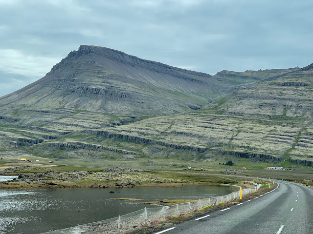
The east side of Iceland is quite rugged and the Ring Road winds through steep valleys and still snow-covered mountains. Note the fog in the valley bottom which was short lived.

Layer after layer of late Miocene (about 9 Ma) basalt lava flows are seen on this stretch. Note the two vertical dikes on the right side of the photograph that stands out in erosional prominence and cut through the older lava flows. Other ravines in this view may also be the location of dikes that have alternatively eroded more deeply in to the flows.

There are many long tunnels in Iceland that cut through the mountains to shorten driving times or bypass steep or often-snowbound stretches of road. This one is six kilometers (four miles) long.

Where there are not tunnels, the road winds in and out of deeply set fjords.

Small towns with only a few hundred residents are often seen along these deeply set fjords.

All around Iceland's coast, the layered basalt rocks are tilted inward to the center of the island (and away from the sea). This is due to isostatic rebound being more pronounced along the coasts, where ice-free environments began much earlier at the end of the last Ice Age. In other words, the central part of the island is still being depressed from the weight of the still-existent (or recently removed) ice, while the coastal areas have been rebounding for longer periods of time. Amazing!
 
One place has scree coming directly to the coast right off of the mountains. A road was not constructed across this scree until the early parts of the 20th century.

South Coast

After passing the town of Hofn, the road swings west to travel along the south coast.

By now, you may have wondered, "Is there any ice in Iceland?" The answer is a resounding yes! Nearly 11% of land is ice-covered in 269 named glaciers. In the distant view here is the largest of them all called Vatnajokull. It is from this glacier that the outburst floods seen in previous blog posts came from (but directed to the north away from the glacier). Here on its south edge, huge tongues of ice spill from the mountains down to near sea level (the south coast gets much more precipitation than the north coast). Just 115 years ago, the ice here extended down to where the photos was taken, about two miles. The pro-glacial lake where the icebergs are floating was born only at that time as the glacier receded.

Another valley glacier was visited just a bit farther west.

Glacier scene in Iceland. Note the Zodiac boat taking passengers on an iceberg cruise.

After passing the nearshore glaciers, the farm and waterfall scenes on the south coast return.

I had been hearing about a canyon along this part of the coast and decided to explore a bit and take a look. Luckily, I had two folks who by now were way into anything resembling "Exploration." It turned out to be well worth it!

 It is called Fjadrarglijufur Canyon and it slices through a sequence of palagonite, a volcanic rock that cools in the presence of water. Palagonite typically suggests eruptions in a subglacial volcano. 

A beautiful scene looking down the canyon.

The basalt columns at Dyrholaey are visited by many who come to Iceland. The vertical columns are often six sided and formed when the lava flow cooled slowly. The columns are perpendicular to the cooling surface.

The Solheimajokull Glacier has also retreated about one mile in the last century.

A medial moraine is seen snaking its way on top of the glacier and represents where two valley glaciers coalesced as they flowed downstream.

Skogafoss on the south coast. There are actually about 50 people looking at the waterfall but I placed my camera in a position where the nearby grass obstructed them.

An eroded subglacial volcano along the Ring Road. Note the tilted beds of palagonite where the effusive material was trapped beneath the glacier and avalanched downslope.

Seljalandsfoss was a final waterfall visited in a land of waterfalls! Some visitors to Iceland report having waterfall fatigue on their journeys. There are many!

Seljalandsfoss.

It's possible to walk behind the falls.

Nearby is a small slot canyon with an anteroom waterfall.

In the anteroom. Thanks for reading!

Thursday, August 05, 2021

Tiny Grimsey Island on the Arctic Circle

Iceland is a BIG island. But lying to its north is Grimsey, the only part of the country north of the Arctic Circle.

Scenic flight from Akureyri.

Standing on the circle on Grimsey.

Puffins!

Puffins!

Only 25 people stay throughout the year on the island.

Basalt columns in Grimsey harbor. The ship at anchor is Le Champlaine. I was to have been on her in June and this was her first cruise since the pandemic began.

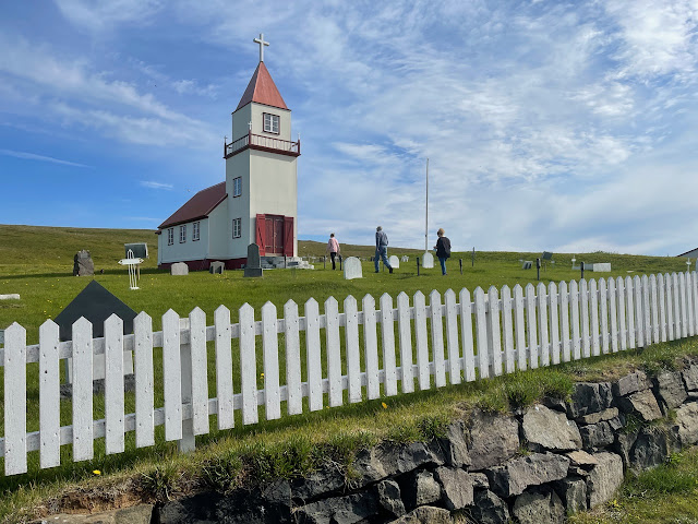
The church on Grimsey.

Storm doors...

...and a close-up.

Downtown Grimsey.

Smoked puffin on the left, cod in the middle and pan-fried puffin on the right (fruit jelly on the far right). Honestly, I laughed out loud when it was served, as the pan-fried puffin looked exactly like a turd. It was exceptionally good tasting however.

Flying away.

Back on the mainland, we stopped at Godafoss.

Near Egilsstadir where we spent the night. The last few posts will be of east and South Iceland.