We finally started toward the Canadian Rockies from Whitefish Montana. Note that geologically, the rocks in Glacier National Park, USA are considered part of the Canadian Rockies. The map above shows this. Taken from
Handbook of the Canadian Rockies, by Ben Gadd.
At the international boundary near Eureka, Montana there are many glacial
drumlins. This is the "toe" or downstream end of an elongate drumlin - the head was located across the boundary in Canada.
This is the
Rocky Mountain Trench, a geologic feature that can be seen from space that trends from Flathead Lake in Montana to the northern Canadian Rockies. It is a long, linear valley about 1,000 miles long and from 2 to 10 miles wide. Although overprinted with glacial scouring, its origin is still debated although it must be fault related. We drove through the trench from Whitefish to Radium Hot Springs in British Columbia.
This is Columbia Lake within the Rocky Mountain Trench near the small village of Canal Flats, BC. This lake is the headwaters of the mighty Columbia River. The Kootenay River is located just 1.2 miles south of this lake and Canal Flats lies between the two.
The drainage pattern here is extremely interesting! The entire Columbia drainage is highlighted in light blue and the Kootenay is in red. Columbia Lake in dark blue and Canal Flats is orange square. Be sure to read
this link to learn more about this juxtaposition of the two rivers.
After crossing the Kootenay River drainage and across the Continental Divide into Alberta, we entered the heart of the Rockies. This is
Castle Mountain near Lake Louise. The upper cliffs are composed of Cambrian-age limestone and shale that are age equivalent of the Burgess Shale farther west (behind the photographer). The Castle Mountain Thrust fault has put these rocks on top of younger late Paleozoic to Mesozoic sediments. The thrust fault can be seen conveniently at about tree-line in the photo.
Lake Louise from the 7th floor of the Fairmont Lake Louise Hotel.
Famous Lake Louise... had a zillion people on it even in the light rain. And...
...doesn't really compare to the view of Peyto Lake seen from above along the Icefields Parkway.
The blue color is due to the suspended glacial flour (ground up sediment). The lake was named after
Bill Peyto who was an early trail guide in the Rockies.
The Athabasca Glacier spills off of the Snow Dome plateau. It is famous for its Snowcoach trips onto the ice. The glacier is also famous for its phenomenal retreat since the beginning of the 20th century. At that time, the glaciers edge was located where the highway is today and the retreat since then is about 1.5 miles.
A view of Snow Dome, which serves as a Triple Divide, forming the headwaters for the Athabasca River (Arctic Ocean), the Blueberry River and Columbia River (Pacific Ocean) and the Saskatchewan River (Atlantic Ocean and Hudson's Bay).
Maligne Canyon cuts through the Devonian Palliser Formation.
The canyon is dramatic in its rapid fall through the slot canyon.
Slow time exposure of the falls in Maligne Canyon.
Maligne Lake near the town of Jasper.
Spirit Island on Maligne Lake.
On the way down the lake we were told of a large, prehistoric (but post-glacial) landslide on the east side of the lake. You can see the scar from this slide through the trees.
House-size boulders not only lined the east shore of the lake but were seen on the western shore as well (behind the photographer). For a birds-eye view of the slide,
see this graphic.
A black bear (
Ursus americanus) came into view as we drove down the valley. It is estimated that there are over 400,000 individual black bears in Canada.
He then crossed the road looking bit sheepish. Black bears are most closely related to the grizzly bear and polar bears and diverged from a common ancestor about 5 million years ago.
The town of Jasper and the Athabasca River as seen from the Jasper Sky Tram. The blue lakes likely occupy oxbows along the river.
A geologists paradise - upturned strata! This is along the Icefield Parkway.
Our trip included a stroll out on the glass covered Skywalk above the Suwampta River.
The woman. on the left is afraid of heights but made it a point to overcome this fear.
A view out onto the horseshoe.
As it is with the glass Skywalk at Hualapai, Grand Canyon, folks are initially all gaga about the glass structure. But ultimately the gimmick gives way to what can be observed from the "teaser." Here, we can see that the Suwampta River is slicing its way through about 200 feet of loose chaotic debris. Note the very large, angular boulders on top of the debris. Hmm?
Further downstream, I noticed these little waterfalls spilling over a cliff into the river. The falls are issuing directly from the ground where the debris is in direct contact with in-place, bedded limestone. The lightbulb went off - the water must be traveling through the subsurface in very porous rock and is ultimately forced to the surface where it encounters the solid limestone bed.

The larger view reveals the story! A very large series of landslides let loose from the mountains on the skyline, damming the Suwampta River. The former course of the river lies beneath the lower forested terrace. Once a reservoir formed upstream from the landslide, water spilled from its lowest rim and began to excavate the canyon. Evidence for multiple slides comes from the coloring seen in the loose material within the gorge - note the gold-colored band in the middle, covered by exclusively gray material on top Looking to the saddle in the upper right, we can see oxidized beds as the source of the middle slide and gray limestone to its left as the source of the upper debris.
The Saskatchewan River flows lazily from Howes Pass to the Alberta prairies (right to left in this view). Not strictly a drainage divide sat this location, Howes Pass was named by David Thompson in 1807 as a way toward the Columbia River.
Bow Lake along the Icefields Parkway.
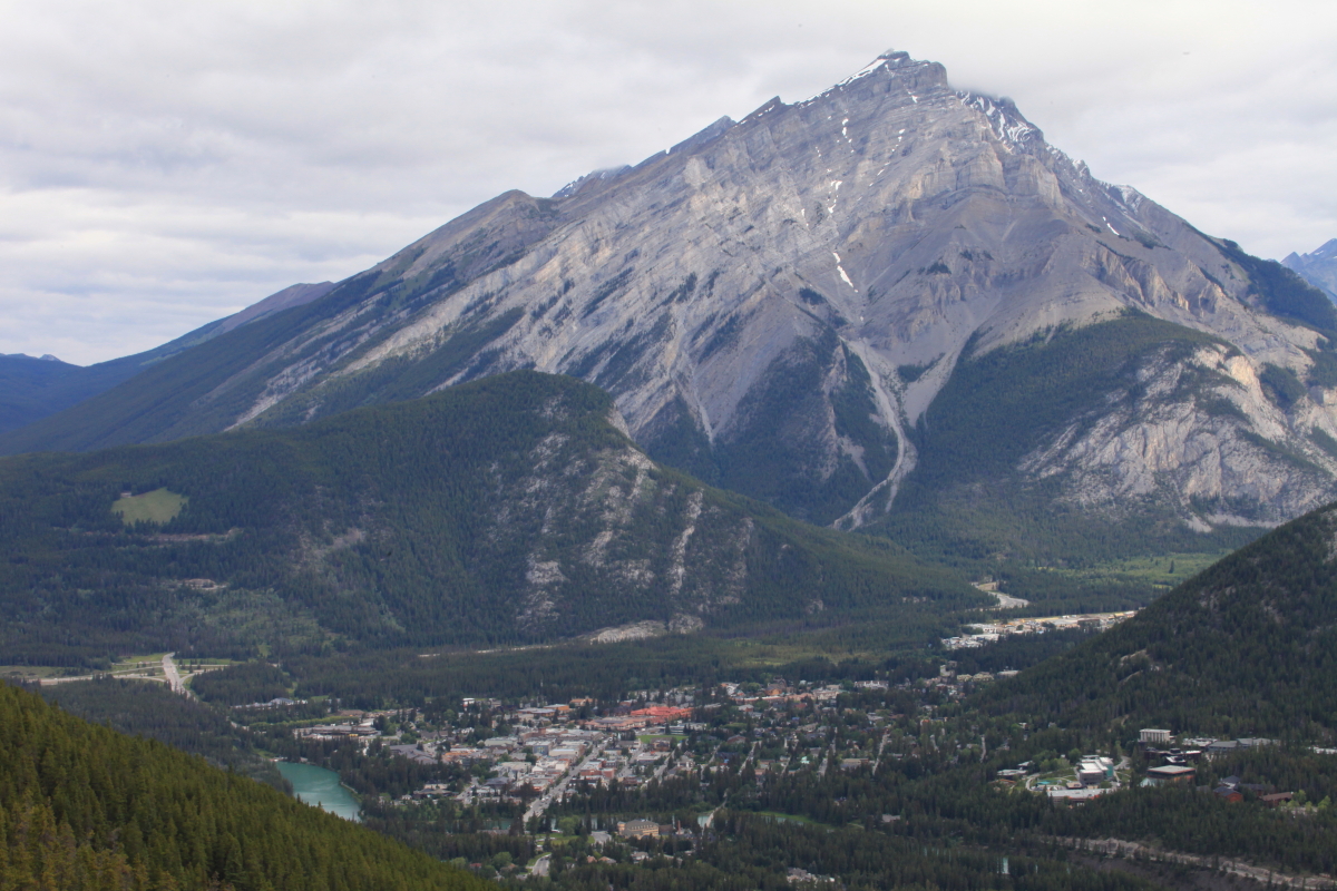
The town of Banff from the Banff Gondola. Cascade Mountain rises 9,836 feet above the town to the north.
A thrust fault likely underlies this valley west of Cascade Mountain.
Highly contorted bedding near Banff.
Wide-angle view with Cascade Mountain (left), Lake Minnewanka (background), and Tunnel Mountain between the two and the Bow River.
What a wonderful trip with a wonderful group of people. Thank you Canada!


Ah, me old stopming ground. Lovely write up. I'm surprised you didn't mention the ancient Bow River probably flowed through the valley where Minnewanka is - and that a glacial dam likely caused it to cut through where presnt-day Bow Falls is and cut poor little Tunnel Mountain right off the end of Mount Rundle.
ReplyDeleteWHAT A PLEASURE TO READ THIS BLOG! vERY HELP FULL FOR ME, I HAVE BOOKMARKED YOUR BLOG, THANKS FOR SHARE WITH US.
ReplyDeleteBeautiful photos.
ReplyDelete