Monday, August 13, 2018

The South and East Coasts of Iceland

I've been so busy on this trip and at the end of the day I just collapse in bed. But here is a hastily written post.

Iceland never disappoints - neither the geologist or lover of nature. Here, innumerable basalt lava flows are stacked one above the other, all battered by the cold North Atlantic wind. And this is summer!  Rain and clouds are your constant companions, making this an unlikely but no less exotic island that is also a country. Every time I come here, I feel just a bit more Icelandic.

The Harpa in Reykjavik. This is the city's concert hall.

The country is booming with tourism, growing at 20%-30% each year for five straight years. 230,000 visitors came just in July alone. The entire country has only 350,000 residents.

Heading out of Reykjavik to the east we had a view of Esja Mountain, composed of numerous basalt lava flows dated between 3.3 and 0.8 million years.

This is þingvellir (pronounced Thing-veth-lear) where the Icelandic rift is pulling lava flows apart (photo center) The graben valley on the right has been faulted down and has formed just in the last  10,000 years at the end of the last Ice Age.

Walking between the rifted lava ramparts. It is often mentioned that this is the plate boundary between two plates - North America on the left (west) and Eurasia right (east). However, the plate Shown on the right is actually a microplate that exists between the two larger plates with a dimension of about 40 miles wide. Still, this a convenient place to tell the story.

Farther down the trail in the rift valley.

Looking up at the faulted edge of the North American plate. The other side of the North American plate is located along the San Andreas fault in California. One time I took a basalt rock from the Icelandic rift (outside the National Park) and dropped it off at the San Andreas fault near Imperial California. Geology makes you do strange things that sometimes only Icelandic trolls can appreciate.

Iceland's most powerful volcano - Heckla. We had a great day as you can see and I had never before seen Heckla so clearly visible.

Gullfoss (Golden Falls) has water coming from one of Iceland's four large glaciers, Langjökull.

This is the area of Geysir and the word "geyser" comes from this Icelandic place.

Geysir itself no longer erupts due to earthquake activity and man's interference. But nearby Strokkur blasts off every two to six minutes. It is a perfect geyser for visitors in this respect.

Geysers need three things to form, a water source, heat, and a plumbing system. Iceland provides all three.

A single eruption (shown in the next two photos) begins with a steam bubble blasting upwards through the water column...

...and spraying superheated water skywards, followed by steam.

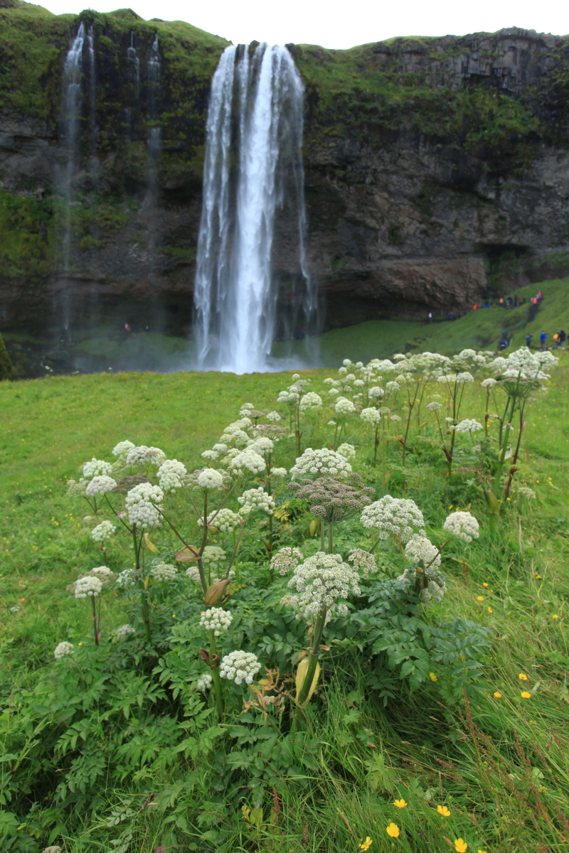
The approach to Seljanandsfoss waterfall ("foss" is the Icelandic word for waterfall and all waterfall names end in "foss").

One can walk behind the waterfall - if you do not mind getting misted on the way.

Angelica (Angelica arcangelica) is an introduced plant in Iceland and grows just about everywhere.

This is the Eyjafelllajökull volcano (a-ya-fet-la-yo-kul) which erupted in 2010 and closed the skies over Europe for three days.

We've seen few puffins along the way.

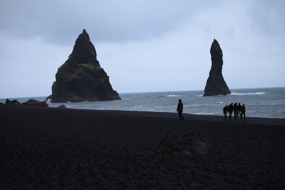
The beach at Reynisdrangar is almost always dark and gray - this is near the wettest spot on a very wet island. The view to the west is towards Dryòlaey.

There are the eroded remnants of the conduit to a volcano. The heavy North Atlantic surf has gradually worn the volcano away, leaving the conduit rocks standing tall.

Skogafoss waterfall along the south coast.

And then we got a surprise. From the day we first arrived, there was a warning about a possible jökulhlaup from the Vatnajökull glacier. These are glacial outburst floods that occur when hot material beneath the glacier begins to melt its underside, creating a pool of water that can suddenly be released out from the glacier snout. For our first few days, we heard that the Ring Road that encircles the island might have to close if the flood became large enough. In due course, the warning was relaxed. We were all set to make a bathroom stop in Vik, when our local guide got a call that they might close the Ring Road because of unusual behavior regarding the flood. We rushed forward 30 miles to miss the closure but to no avail - the closure was in effect.

And this is why - the flood had not taken the usual path down the Skafta River channel, but rather was being piped through a very porous lava flow that was laid down during the 1783 Laki eruption. The sub-lava flow of water was then shooting up from within the lava flow, flooding the Ring Road! Photo courtesy of a Reykjavik newspaper.

Our bus was diverted onto a dirt road (along with everyone else) south past the lava flow.

Here is the Skafta River with the surficial portion of the jökulhlaup - you could smell the mud and the sulphur.

Sign at nearby Vatnajökull National Park announcing the road closure.

A former bridge after a jökulhlaup in the 1990s. It is now a roadside attraction.

These are the "Dwarf Cliffs" basalt columns called Dverghamrar.. They can be found along the southeast Ring Road.

The columns present their top side where the six-sided columns can be seen. See a list of the 10 most interesting basalt columns in Iceland here.

This shot shows a well-proportioned colonnade below, topped with a many-faceted entablature. The whole mass is within a single lava flow but the entablature was cooled in the presence of water. Joints form perpendicular to the cooling surface. Thus, in the colonnade, cooling was from the top and bottom. The joints in the entablature formed haphazardly when water from above seeped into the lava flow.

This is Icelands tallest mountain, Öræfajökull, at 2109.6 meters or 6,821 feet. It was listed at 2119 meters until a remeasure in 2007 set its current height.

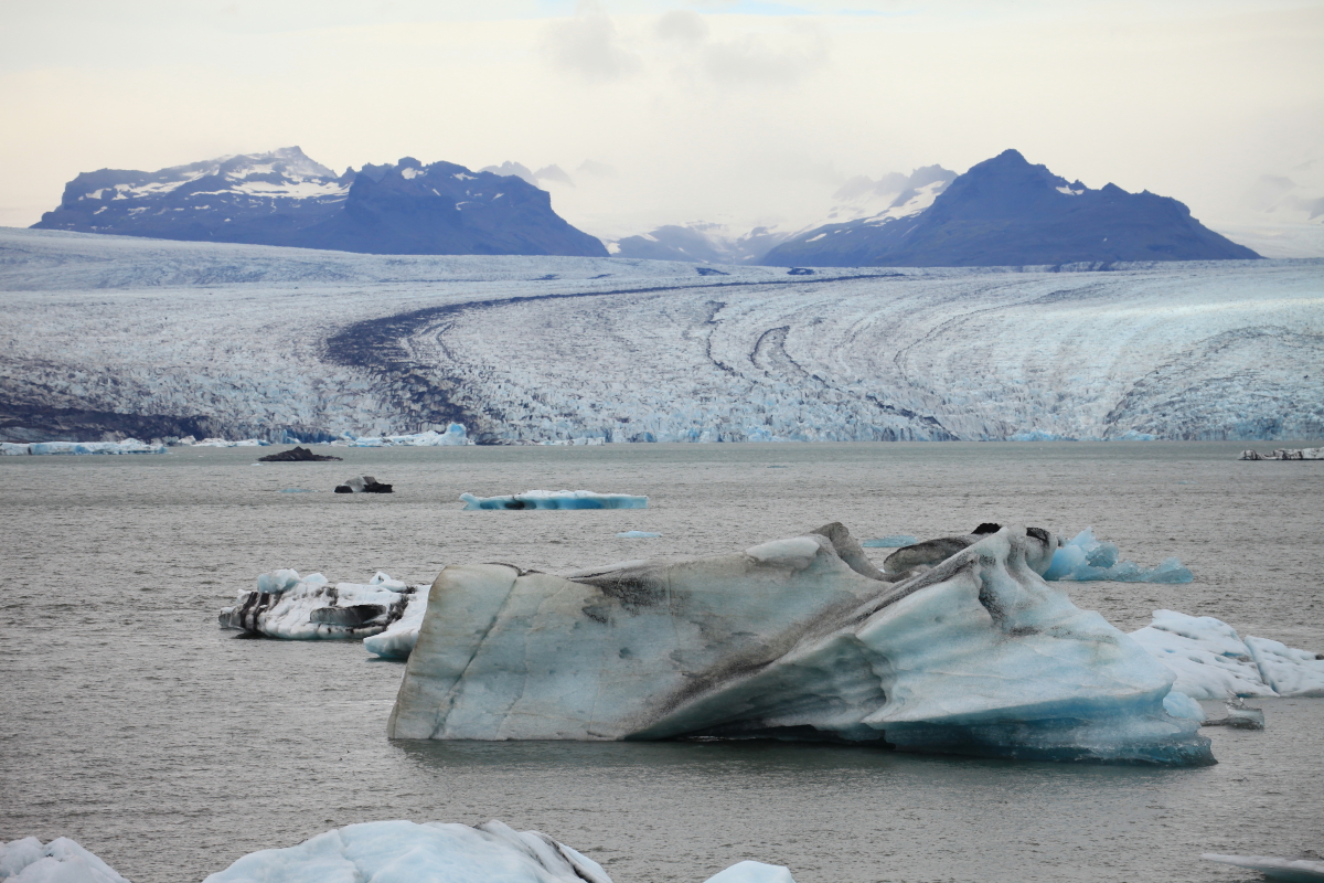
A tongue of the Vatnajökull glacier spills out of the mountains. Note the medial moraine on its right side where two valley glaciers came together.

A second glacial tongue from the mountains.

Icebergs in the glacial lagoon.

This is probably how most people think of Iceland - at least those who have not yet been.

Icelands east coast.

It was dark, grey and rainy on our east coast traverse.

East coast lavas and dikes. It's too bad the weather was grey and cloudy while we were over here. What emerged from beneath the clouds looked interesting. 

Tuesday, July 31, 2018

Iceland Circumtransit With Yavapai College Begins August 1

I am going back to Iceland! This time with Yavapai College EdVentures. I will be blogging from there so watch Earthly-Musings for stories and photos in the next few weeks. Here are some teasers from some of my previous trips to Iceland.

Looking south along the Mid-Atlantic Rift at Þingvillar National Park (pronounced Thing-vadth-leer). The Eurasian plate (left) is being pulled away and collapsing downward adjacent to the North American plate (right). Þingvillar Lake is resting in the downdropped basin.

Pahoehoe lava textures at Þingvillar.

The gorge at Gullfoss (Golden Falls).

At Geysir, and the namesake for all the world's geysers, the Strokkur geyser erupts about every 6 minutes. I caught this boiling bubble just as it was about to explode.

The southern coast of the Snæfellsnes Peninsula at Arnastapi Beach.

This valley near Dettifoss Falls was carved by a catastrophic outburst flood let loose from beneath a glacier within the last 10,000 years. We are hoping for weather like this!

Monday, July 23, 2018

Green River Geology - Echo Park, Whirlpool Canyon and Split Mountain Gorge

Continuing on our rafting trip just past the mouth of the Yampa River, we entered Echo Park, a lovely glen that is perched slightly on a Pleistocene (Ice Age) terrace along the Green River.

The mature Fremont cottonwood trees (Populus fremontii) that line the river are lovely but are losing their foothold here as the river cuts into the terrace on its outside bend. We saw large tree trunks that were undercut by the river. Additionally, prior years grazing caused the young shoots too be trampled and eaten by cattle. The National Park Service has established a cottonwood nursery back up against the wall in the distance, and is replacing the trees on the terrace.

This is our lunch stop across from Steamboat Rock. J.W. Powell camped here between June 17 and June 21, 1869 and named the promontory Echo Rock. I found myself wanting to call it that as well on this trip. The rock was the site of a well-known incident from the trip. Powell and George Bradley climbed the rock to obtain a reading with their barometer. As they scrambled upwards Powell leaped across a gap into a small crevice and found himself unable to move forward or back. He called to Bradley for help, who then climbed above the crevice. Powell then explains, "The moment is critical. Standing on my toes, my muscles begin to tremble. It is sixty or eighty feet to the foot of the precipice. If I lose my hold I shall fall to the bottom...At this instance it occurs to Bradley to take off his drawers, which he does, and swings them down to me. I hug close to the rock, let go with my hand, seize the dangling legs, and with his assistance am able to gain the top. Then we walk out on the peninsular rock, make the necessary observations... and return finding an easy way down." 

The Mitten Park fault has upturned the once flat-lying beds of the Morgan Formation. When the crust began to be compressed and squeezed in a mountain building event known as the Laramide orogeny, the rocks were first bent. Then, as the pressures became too great, the rock layers broke and were faulted. The actually trace of the fault is in the canyon on the far left, where our guide is pointing. A few things to keep in mind - when all this occurred, the rocks seen today were buried by about 5,000 to 10,000 feet of additional strata that have since been eroded away. When rocks are buried that deep, they are hot and can bend more easily. And, it all happened between about 70 and 40 million years ago. The nondescript looking rocks on the left are older and uplifted higher than the colorful rocks seen on the right.

After leaving Echo Park and crossing the fault, we entered Whirlpool Canyon. In the downstream view is the site of the Echo Park Dam. In the 1950s this area almost became inundated in water by a reservoir. You can read about the controversy and its rather happy ending here.

Gloria in fine form on the stand-up paddle board.

Whirlpool Canyon is cut into rocks of the Uintah Mountain Group, the dark knob on the left. This knob was in existence - much as we see it today - some 500 million years ago! How do we know? The whitish, flat-bedded Lodore Sandstone on the right has been dated to this time and it pinches out and laps onto the older Uintah Mountain Group. A similar relationship between what are essentially the same rocks in the walls of the Grand Canyon, occurs farther south about 500 miles.

Close-up view of the onlap relationship of the darker Uintah Mountain Group and the lighter-colored Lodore Sandstone. This relationship reveals that there was an undulating, hilly plain in existence when the sea began to encroach upon and bury it. The Green River has exposed it all once again.

View upstream in Whirlpool Canyon to Harpers Corner viewpoint. Before the river trip, Ed, Howard, and I drove out there. Our camp next to the river is located near the Colorado/Utah state line.

My bed for the night. I love to have these little perches next the beach and the water.

These pictographs were seen on our hike up Jones Hole and are likely from a cultural group called the Fremont.

Stylized bighorn sheep.

Anthropomorphs.

This is Ely Falls, a tributary of Jones Hole. We sat in the shade here and watched the earth turn for about two hours. Nice spot.

The north facing wall of Whirlpool Canyon. I was intrigued by the sharp buttresses that separated the rills in the hillside. It made me wonder if some peri-glacial conditions might have caused this?

J.W. Powell called this Mt. Hawkins, located across from our last nights camp. The Pennsylvanian Morgan Formation is tilted down to the west. This alternating grey limestone and red sandstone reflects the fluctuating sea levels around 300 million years ago, when ice caps in the southern hemisphere waxed and waned, changing the level of the sea, and thus the sediment types worldwide.

Aptly named Rainbow Park, an open expanse formed within the Island Park syncline.

Note the vegetation-covered slope between the two sandstone buttresses. This is likely a former channel of the Green River that was filled with sediment during a prior aggradation event. Later downcutting bypassed the former channel and into the present one, which curves to the right.

A huge bison petroglyph left by Ute Indians.

While taking a picture of this large raptor (immature Golden eagle?), I accidentally caught an accipiter (?) fluttering nearby. Can any of my knowledgable bird friends identify the two?

Floating towards the Split Mountain anticline.

Entrance to Split Mountain Gorge. Amazing how the river enters this uplifted "barrier."

This single feature caused J.W. Powell to speculate on the history of the Green and Colorado rivers. In fact, his observations here were later used to also explain the Grand Canyon. Trying to come to terms with a river entering the uplift, he proposed a new process known as antecedence, whereby the river(s) was/were in place before the uplifts occurred. Later uplift proceeded slowly so as not to alter the course of the river, thus cutting into the rock mass like a saw working on a piece of lumber. Other geologists weren't so sure and the first "controversy" regarding the origin of the river was born.

Inside Split Mountain Gorge, we saw this most interesting fault and fold. During uplift, a wrinkle formed in the strata which began to bend the layers. Then the stress became too great and the upper portion slid over the lower part toward the left. Wow!

Samuel F. Emmons had also completed work in this area around the same time as Powell and found evidence that the uplift was actually older than the course of the river (thus opposed to Powell's interpretation). Envision the upwarp already in place when it gradually was buried in lake sediments of the Green River Lakes. The lake sediment ultimately formed a subdued surface with the uplifted rocks buried and encased within. Then the rivers' course was established on top of the subdued surface and only coincidentally on top of the buried uplift. As the river cuts down, it encounters the fold and begins to slice through it. This process is called superposition and it is the likely explanation for these spectacular canyons. Archibald Marvine, who also worked in the Rocky Mountains along with Powell, found the same evidence for superposition.

Exit of Split Mountain Gorge. What a great trip with a great group of people! I may be doing another one of these five-day rafting trips on the Yampa River next year. Write to me if you are interested.