Sunday, January 19, 2014

Cape Town, South Africa

Cape Town is one of my favorite destinations. The combination of a Santa Barbara-like climate, fantastic scenery and geology, and a wealth of Interesting historical sites makes it a very much looked-forward-to stop.

Table Mountain with the Cape Town skyline in the foreground. I took this shot on the ferry over to Robben Island.

Approaching Robben Island

Entrance to the prison

View to the mainland from the island. Table Mountain rises over 3,000 feet above the city. The rocks in the foreground are part of the Malmesbury Group (the Sea Point Formation), metamorphosed sandstone and shale that are the basement to the overlying rocks on Table Mountain. The foreground rocks were deposited about 850 Ma.

Close-up of the Sea Point Formation on Robben Island

Robben Island covers about 1000 acres of land

Oyster catcher sitting on two eggs, visible directly beneath her breast and cryptically the same color as the rocks in the nest

Nelson Mandela's cell within the prison

The guides are always excellent here and are themselves ex-prisoners. This one, Oliver, made an interesting comment at the end of his tour. He thanked all of the people of Belgium, Germany, the United States, and all of the countries of the world that put so much pressure on the Apartheid government of South Africa to end this policy. It was both moving and insightful.

Back at the Waterfront area of Cape Town. This is a very lively redevelopment area with shops, restaurants and museums.

Next up was the cable car ride and hike to the top of Table Mountain. This view is looking south along the coast of the Atlantic Ocean.

This map shows the six Floral Provinces of the world with the Cape Floral Province as the smallest but one of the most diverse. A series of flower photographs follows.


Table Bay and Cape Town from Table Mountain

Return trip down the mountain with the Lion's Head on the left.

Thursday, January 16, 2014

The Domes of Fabedougou

We'll is is a new reality in blogging - the iPad app for Blogger allows me to construct blog posts without an internet connection. So as we are taking a 7-hour flight to Cape Town today, I am writing this text and adding photo's from yesterday's visit to Babo Diolausso, while listening to tunes on the iPod. I guess that makes me an iBlogger. A large overcast below as we enter Angolan airspace, and I just finished giving my second lecture, "Africa - Cradlepp of Human Evolution and Cape Town's Captivating Landscape".

Our last stop in Burkina Faso was to some fantastic rock formations called the Domes of Fabedougou. They are composed of Mesoproterzoic sandstone that is incredibly un-metamorphosed. For being 1,800 million years old (and coincidentally the same age as the much tortured Vishnu Schist in Grand Canyon) these rocks are surprisingly young looking.

A first view

WooHoo! Rocks!

Imagine ripple marks almost 2 billion years old. The sandstone was friable (breakable) as well. It really didn't seem so old.

We were able to climb up on one of the domes for a good view

Differential weathering gives the rocks their layered looked. The horizontal projections are sand layers with extra cement, while the indented horizons are finer grained sand of perhaps mud which is not so well cemented. Each layer weathers at a different rate based on the amount of cement.

Close-up of cross-bedding within the sandstone

It was a fantastic stop

Fabulous Fabedougou

Return to the jet in Bobo


One of the Captains and the cabin crew always meet up on the way back.

It is a very pleasant group with about 90% of the guests having taken a jet trip with TCS before. We've had some great conversations so far.


Bobo Dioulosso Mosque and Market

The next day we got to fly in the jet one hour to the southwest. We landed in Bobo Diolousso to see the interesting mosque, built in 1888.

Exterior with wood slats to help with adobe maintenance

Adobe is really a big business here. We saw many areas along the road where the bricks are made.

On the roof of the mosque 

Street scene in Bobo

Street scene

Bobo vegetable market - one of the most colorful and lively I've been to. This woman was obviously pleased at the selection of tomatoes, possibly walked to the market from up to five miles away on the sellers head.

Faux jewelry

Okra and very hot yellow peppers

Anything canbe bought here, even fine grassi

Full moon over Wah-gah-du-goo! Photo taken just after nightfall at the Ouagadougou Airport on January 15. I will next blog about the fabulous rocks seen at Fabedougou.


Wednesday, January 15, 2014

More Burkina Faso

I want to get some more pictures up before we leave Burkina Faso. Older readers may remember that this country used to be called Upper Volta. The name was changed in 1984 and Burkina Faso means, "Land of the Dignified People". We saw some good geology today and you'll see those pictures at the end of the post.

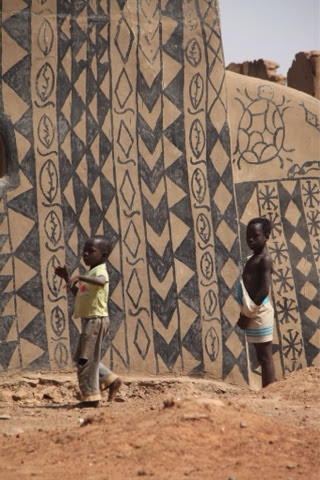
We went to a small village near the border with Ghana called Tiebele. It was a 2 hour drive by bus. Here is a sequence of photos showing the progress on painting the wall of this house.

Yep - they are singing while they apply the paint.


Now the design is painted over the brown color

It begins to look good!

This was my final shot of the house painting - had to see the rest of the village.

Children coming to see the strange-looking visitors

A woman cooks roots to make red dye

And poses for a picture. The village is real and is famous in this country but the house painting is now performed for visitors, of which there are not many.

A baobab tree in the village: http://www.blueplanetbiomes.org/baobab.htm

The people are friendly, quite to smile, and ever so poor by our standards. Yet they seem to be pleased with their lives.


Tuesday, January 14, 2014

Flying to Burkina Faso

On Monday, January 13, we left Madera Island and flew across the Sahara desert to Burkina Faso. I gave a slide illustrated lecture along the way called, "An Introduction to Africa's Landscape". Unfortunately, I didn't see the Morocco landscape below me as I gave the lecture. But I did get to see one interesting feature while flying over Mauritania. This is the Richat Structure, also known as the eye of the Sahara desert. It was initially thought to be a meteorite impact structure, but further geologic mapping failed to show any impact minerals such as coesite. A short description can be found here: http://en.wikipedia.org/wiki/Richat_Structure and here: http://geology.rockbandit.net/2008/09/25/richat-structure-in-mauritania/. What a treat it was to fly over this and photograph it from 39,000 feet up.

Richat structure in Mauritania. The outermost rings are Ordovician-age limestone with Proterozoic rocks in the eye.

The Niger River in Mali

Sunday, January 12, 2014

Madeira Island

It's raining today on Madeira Island but we set out anyway to explore some of the things to see here. Plus, it seems that my laptop computer has finally died and the procedure I normally use to upload photos is not available to me. So I figured out a way to take photos with an iPad and then upload them directly to Blogger. So just a few photos today as I figure out how this all works. 

I first visited this island in 1990 while working for Lindblad and we arrived by ship. The change in those 23 years is astounding. Back then it seemed like a rural, out of the way backwater but today it has a freeway and many many more people and hi-rise apartments. I attribute the growth to the islands economic connections to all of mainland Europe through the European Union. What a difference although this is my fourth or fifth time here and the change was imperceptible before. 
Valley of the Nuns from above

Close-up view

The spectacular valley walls are composed of layered basalt lava flows but the valley bottom contains a layer of relatively unconsolidated pyro classic tephra (cinders). When the stream in the valley dissected into the cinder horizon, it caused the otherwise dense basalt to collapse, forming the valley. The oldest sub-aerial lavas here are 5.6 Ma but only 4.2% of the volcano is above sea level! That means that 96% of the volcano reside below the sea, an astounding thought.

Driving on the narrow, hilly roads is a colorful experience

We visited a local winery and got to taste the famous Madeira aperitif

Oak barrels for aging the wine

Local vintners 

The island is about 40 miles long and 20 miles wide with 300,000 inhabitants. It has no archaeologic sites and the first people known to have seen it were Portuguese navigators in the 16th century. If I had the ability to attach a link, I would do so for Madeira but as I say, this posting is an experiment using an iPad.