 |
| Photo by Dawn Kish - From the top of the Rattlesnake scoria cone; the reddish arc behind the figure is Rattlesnake maar |
View of the west side of the maar where the truck is parked. We are on the rim of the maar at this location and simply walked up the gentle slope on the two-track road around to its crest. The snow-capped San Francisco stratovolcano lies in the distance to the west, with other cinder cones in between. Cinder is a term in common usage but geologists also use terms such as lapilli and scoria. All are any pea-sized ejecta that forms when droplets of molten lava are thrown into the air and cool and harden. Scoria contains more vesicles, being the basaltic equivalent of pumice. Thus, the cones can properly be referred to as cinder cones, lapilli cones, or scoria cones.
Looking south to the scoria cone that formed after the tuff cone. The evidence for this is that the southern part of the tuff ring is buried beneath the scoria cone. This was a great hike. For the geologist, I include the next section on maar volcanoes.
Maar's are broad, low-relief volcanic craters found not uncommonly on Earth's surface. Check out this Wikipedia site for some examples of maar's found around the world. They form when hot magma rises into the upper crust and interacts with water. On continents this usually is groundwater but can also be lakes or rivers. When the magma encounters the water a phreatomagmatic eruption occurs. These are violent steam ejections that emplace tuff around the vent. Krakatoa in Indonesia, which erupted in 1883, is an example of an especially large and explosive phreatomagmatic eruption.
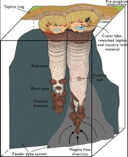
Geologists are also interested in the subsurface structure of maar's. The diagram above is used courtesy of Dr. Steve Semken at Arizona State University. It shows a typical carrot-shaped diatreme that underlies a maar volcano. One of the most famous exposed diatremes is Shiprock on the Navajo Nation in New Mexico.
Dr. Semken created this cross-section that places two different, but nearby surface features one on top of the other. They share a common ancestry but one (Shiprock) is the more deeply eroded feature. In other words, before Shiprock was so deeply eroded, it was covered by something akin to the Narbona Pass crater.
Dr. Semken, along with colleague Larry Crumpler of the New Mexico Museum of Natural History, also created this photo collage of the two features. On the bottom is an aerial photo of Shiprock with its presumed diatreme margins added. These project upwards into a second aerial photo of the Narbona Pass crater. I think this image really relates two different parts of maar formation.
This is an excerpt of the USGS geologic map - MF-1960. I have colored some of the pertinent features using the Macintosh Keynote program. The tuff ring of Rattlesnake maar is colored dark purple. Note how it is not present on the south. The Rattlesnake scoria cone is colored lighter purple and overlaps the presumed southern portion of Rattlesnake maar. The brown color denotes the lava flows that issued from the scoria cone and that flowed down the regional slope. Another scoria cone and associated lava flow (not colored), Merrill Crater, can be seen to the east of the Rattlesnake cone.
The map is called "Geologic map of the east part of the San Francisco Volcanic Field, north-central Arizona." You can access the USGS map here: MF-1960.
More cones to come! Thanks as always for reading.


Great write-up Wayne! I concur, I'm no volcanologist but my favorite grad course was Dick Holm's volcanology class.
ReplyDeleteVery interesting information. The explanation and superimposed images of Shiprock are especially fascinating - now I need to visit that area again someday to think about this more. Thanks!
ReplyDelete