I just finished a fantastic four-day exploration of
Nevada's Valley of Fire State Park. The trip was a reunion of sorts with past students and friends from my teaching days at Yavapai College in Prescott and Sedona. They scouted the trip, planned the itinerary, and executed a fine geology program. I am so lucky to have such wonderful alumni and friends! They are awesome.
I had driven through the area briefly in the 1970's and knew the area would be a good one to visit. But I had no idea that it would be OUTSTANDING!! The geology is "off the charts" fantastic and we visited during the spring wildflower season.
East entrance to the park
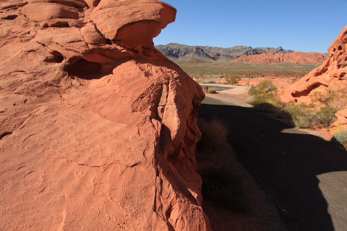
The main story here is that during the Early Cretaceous (145 to 100 million years ago), western North America was subjected to compression from the west and gray Paleozoic limestones were shoved horizontally to the east over Jurassic sandstones. In this overview shot, you can see the result. In the foreground is the Jurassic Aztec Sandstone, while in the background are the Paleozoic limestones. The
thrust fault that created this inverted relationship is known as the Muddy Mountains thrust fault.
First, let's describe the Aztec Sandstone, the rock unit that gives the park its name. It is time equivalent to a common Colorado Plateau unit known as the Navajo Sandstone. They are one in the same but when they were named no one knew that. Geologists could attempt to remedy the discrepancy but they are not generally "lumpers". The Aztec and the Navajo are one in the same.
The Aztec has beautiful
eolian textures like these wind ripple marks
Another set of ripple marks located on the lee side of an ancient dune. Note how the ripples appear to climb up the lee face of the dune. I have seen this occurrance on modern dunes in India and the Middle East.
Close-up of the ripple marks
Balanced Rock shows that the Aztec Sandstone has experienced many episodes of deformation. Here the beds dip steeply to the left (north) recording an anticline that overprinted the thrust.
Balanced Rock framed by a Beavertail cactus in bloom. The flowers on the trip were spectacular.
Petroglyphs on the Aztec near Mouse's Tank
Although the plane of the Muddy Mountains thrust fault is not directly visible here, the result definitely can be seen. The limestones are 500 to 300 million years old and the red sandstone beneath is only 180 million. Imagine the first geologist to ponder this odd relationship and the wonder they must have felt when they realized what this represented. If that is not enough, later studies showed that the limestone here traveled more than
50 miles along the thrust!
From our camp we could look to the Virgin River Valley to the east, known locally as the Overton Arm of Lake Mead (the reservoir has backed up into the valley of the Virgin about 35 miles). The rocks in the distance contain an almost complete section as seen in the walls of the Grand Canyon. The cliff-top unit is the Kaibab Limestone and the prominent cliff in the middle is the Redwall Limestone. I always love seeing the Grand Canyon section of rocks outside of its "normal" home.
A camp scene in Group Site #3
On the second day we explored the northern part of the park to Rainbow Vista. It is aptly named.
Desert marigolds in bloom
The colors in the Aztec Sandstone are a big part of the geologic story here but involve groundwater fluids that remobilized certain iron oxides within it. First the sandstone was colored red by the dissolution of iron rich minerals within it such as mica or hornblende. The iron coated each grain of sand. Then fluids traveled along faults and fractures and removed some of the iron oxide to make the rocks white. Then a third period of groundwater movement brought in purple and yellow staining (limonite and goethite). Thus was formed the rainbow colors of the park.
In some areas the colors blend wildly
Groundwater fluids also hardened the cement within fractures and joints in the rocks
A geology talk in the field is worth five talks in the classroom. I did not have to lead this trip - some of the students did the research and presented to the group
We next took a hike into a fantastic area that is reminiscent of Coyote Buttes in the Vermilion Cliffs
Along the way, the Chinle Formation made an appearance. It is seen as the drab gray claystone in the foreground at the base of the red sandstone.
Fantastic colors
Eroded into wonderful shapes
Valley of Fire reflection time
At the end of the hike we could see the Cretaceous Willow Tank Formation, an assemblage of coarse rocks that unconformably overlie the Aztec
The deposit contains some well rounded quartzite clasts as well as clasts of the Aztec. Hmm?
The lower part is colored red with an upper part that is more gray. This color difference likely reflects what kind of rocks were eroding with the lower, redder beds derived from areas of Aztec Sandstone and the upper grayer lenses from Paleozoic limestone terrain. The interpretation is that this unit is the debris being shed off of the thrust front a few miles west of here. Imagine a highland to the west that originated when limestone deposits were being thrust up to the east over the Aztec Sandstone. As erosion attacked the thrust front, gravel was washed to the east over the Aztec. That is what is exposed here.
Brittlebush in bloom on the conglomerate
We next hiked to the White Domes. Primroses were in bloom along the way.
View into the slot canyon area at the White Domes. Note the dark wall of adobe near the sandy patch on the floor of the canyon?
It is the remnants of a Hollywood set for the 1966 movie, "
The Professionals". The movie starred Lee Marvin, Burt Lancaster, and Jack Palance and many scenes were filmed here and in Death Valley. Ironically, Helen and I watched the movie last night, just days after returning home! I can highly recommend the movie for southwestern scenery.
Many scenes in the movie were filmed in this slot canyon, carved in the Aztec Sandstone
Sandstone, fractures, and light
On the third day, we drove to the Lake Mead National Recreation Area and hiked to the Bowl of FIre. Here Dennis gives the group a short lecture. But this blog is long enough and its time to end.
Sunset on the Muddy Mountains from camp
The group photo at Frenchman's Mountain. Thank you everyone for this wonderful trip!


This desert parks vista looks quite interesting. Would love to go there in summer.
ReplyDeleteGreat pictures, Wayne. I was a grad student of Paul Umhoefer's and did work on the Frenchman Mountain block. I got to go out to Valley of Fire once or twice but always on a time crunch. Your photos brought back memories. That last picture's overlook is a great place to see the sun set after a long day in the field!
ReplyDeleteThanks!
I enjoy your blogs, especially concerning your travels in and around the Colorado Plateau. On your latest, I was dismayed to see that you've apparently succumbed to the silly notion of naming winter storms. This is an entirely unscientific bit of a marketing ploy by the "Weathertainment" Channnel. As a professional pilot who relies on accurate and concise weather data reporting, the last place I would turn to is TWC, especially now that they are trying to foist their latest bit of banality on their viewers.
ReplyDeleteI agree with Jeff Johnson on the absurdity of naming winter storms. I included the reference to it because we were mocking it on the trip. Thanks Jeff.
ReplyDeleteWow, four days, I impressed - I only got to see it as a day trip from Vegas, but I would thoroughly recommend it. Here's my (much shorter!) trip - Valley of Fire
ReplyDeleteOne subject that interests me greatly is the older well established mature ocean bottom which is Keystone thrust and the same visible at Frenchman and other spots. The question then becomes "did the Keystone overthrust cover the entire area and we see only the remnants?" I believe it did and see the evidence hiking around with huge limestone blocks as well as smaller ones always on the surface settled down miles from mountains. As you mentioned that it slid over the older aztec sandstone--just in view southeast across the highway where you were at bowl of fire--it can clearly be seen that the overthrust sits on top of the sandstone. I think this is interesting to see the actual interface slide surface. Normally the older limestone is shown "in the background"--such as at red rock. But in some spots the exact interface is almost a vertical wall. On the view im talking of on the other side of the highway you can also tell that the limestone layers "are barely the final remnants" thanks and your blog and other lectures and info you have is what I refer to most.
ReplyDelete