Well not for this old rock-hound, who remains duly impressed a full two weeks after the announcement was publicized. This truly is the smoking gun for the former presence of running water on Mars. Previous studies have shown that minute amounts of water still reside near the Martian poles and perhaps beneath the Martian surface elsewhere. But this is verifiable and visible evidence that rivers once ran on Mars! (A River Ran On It).
In this posting, I include images released by NASA with their own captions beautifully describing each one (I modified the captions slightly to reduce redundancy). The full story as posted on the NASA web site can be read and accessed here. Wow! This is really impressive. Stay tuned to NASA and this blog for more fantastic discoveries from Mars.

Where Water Flowed Downslope
This image shows the topography, with shading added, around the area where the rover Curiosity landed on Aug. 5 PDT (Aug. 6 EDT). Higher elevations are colored in red, with cooler colors indicating transitions downslope to lower elevations. The black oval indicates the targeted landing area for the rover known as the "landing ellipse," and the cross shows where the rover actually landed.An alluvial fan, or fan-shaped deposit where debris spreads out downslope, has been highlighted in lighter colors for better viewing. On Earth, alluvial fans often are formed by water flowing downslope. New observations from Curiosity of rounded pebbles embedded with rocky outcrops provide concrete evidence that water did flow in this region on Mars, creating the alluvial fan. Water carrying the pebbly material is thought to have streamed downslope extending the alluvial fan, at least occasionally, to where the rover now sits studying its ancient history.

Remnants of Ancient Streambed on Mars
NASA's Curiosity rover found evidence for an ancient, flowing stream on Mars at a few sites, including the rock outcrop pictured here, which the science team has named "Hottah" after Hottah Lake in Canada’s Northwest Territories. It may look like a broken sidewalk, but this geological feature on Mars is actually exposed bedrock made up of smaller fragments cemented together, or what geologists call a sedimentary conglomerate. Scientists theorize that the bedrock was disrupted in the past, giving it the titled angle, most likely via impacts from meteorites.The key evidence for the ancient stream comes from the size and rounded shape of the gravel in and around the bedrock. Hottah has pieces of gravel embedded in it, called clasts, up to a couple inches (few centimeters) in size and located within a matrix of sand-sized material. Some of the clasts are round in shape, leading the science team to conclude they were transported by a vigorous flow of water. The grains are too large to have been moved by wind. This image mosaic was taken by Curiosity's 100-millimeter Mastcam telephoto lens on its 39th Martian day, or sol, of the mission (Sept. 14, 2012 PDT/Sept. 15 GMT).
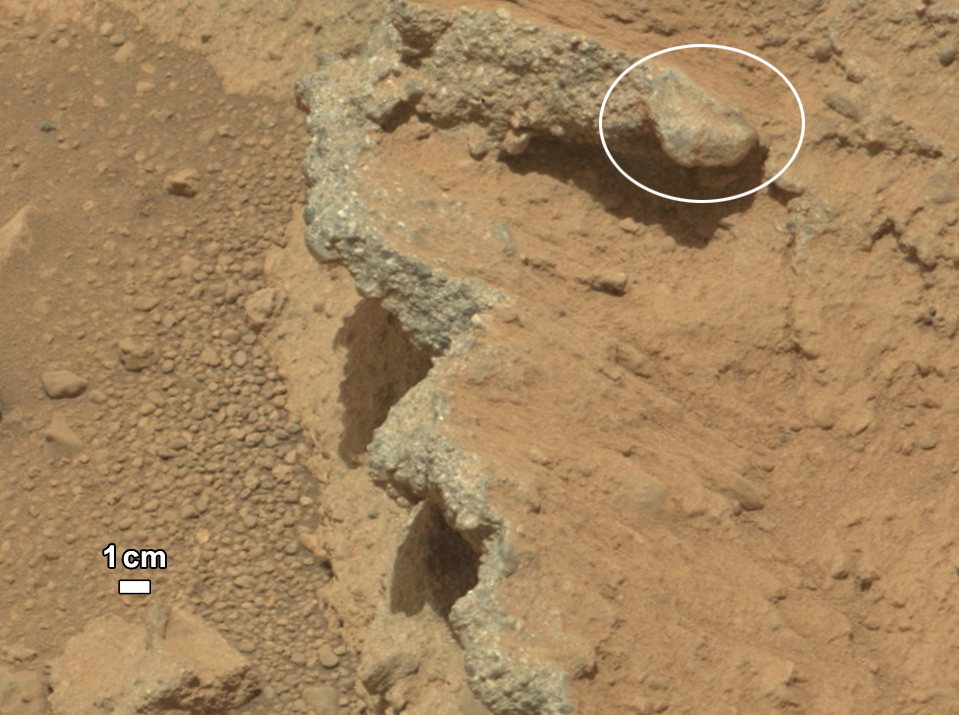
Close-up view of Hottah
A close-up view of Hottah reveals more details in the outcrop. Broken surfaces of the outcrop have rounded, gravel clasts, such as the one circled in white, which is about 1.2 inches (3 centimeters) across. Erosion of the outcrop results in gravel clasts that protrude from the outcrop and ultimately fall onto the ground, creating the gravel pile at left.
Link to a Watery Past
In this image a rock outcrop called Link pops out from a Martian surface that is elsewhere blanketed by reddish-brown dust. The fractured Link outcrop has blocks of exposed, clean surfaces. Rounded gravel fragments, or clasts, up to a couple inches in size are in a matrix of white material. Many gravel-sized rocks have eroded out of the outcrop onto the surface, particularly in the left portion of the frame. The outcrop characteristics are consistent with a sedimentary conglomerate, or a rock that was formed by the deposition of water and is composed of many smaller rounded rocks cemented together. Water transport is the only process capable of producing the rounded shape of clasts of this size. The name Link is derived from a significant rock formation in the Northwest Territories of Canada, where there is also a lake with the same name.Scientists enhanced the color in this version to show the Martian scene as it would appear under the lighting conditions we have on Earth, which helps in analyzing the terrain. Image credit: NASA/JPL-Caltech/MSSS

Rock Outcrops on Mars and Earth
This set of images compares the Link outcrop of rocks on Mars (left) with similar rocks seen on Earth (right). The image of Link, obtained by NASA's Curiosity rover, shows rounded gravel fragments, or clasts, up to a couple inches (few centimeters), within the rock outcrop. Erosion of the outcrop results in gravel clasts that fall onto the ground, creating the gravel pile at left. The outcrop characteristics are consistent with a sedimentary conglomerate, or a rock that was formed by the deposition of water and is composed of many smaller rounded rocks cemented together. A typical Earth example of sedimentary conglomerate formed of gravel fragments in a stream is shown on the right.An annotated version of the image highlights a piece of gravel that is about 0.4 inches (1 centimeter) across. It was selected as an example of coarse size and rounded shape. Rounded grains (of any size) occur by abrasion in sediment transport, by wind or water, when the grains bounce against each other. Gravel fragments are too large to be transported by wind. At this size, scientists know the rounding occurred in water transport in a stream.
Scientists enhanced the color in the Mars image to show the scene as it would appear under the lighting conditions we have on Earth, which helps in analyzing the terrain. The Link outcrop was imaged with the 100-millimeter Mast Camera on Sept. 2, 2012, which was the 27th sol, or Martian day of operations. Image credit: NASA/JPL-Caltech/MSSS and PSI
Seems like water could indicate some form of life.
ReplyDeleteIt would be interesting to know how sediment transport by water on Mars compares to transport by the same amount/velocity on Earth. I'm guessing the water on Mars can do more work with less water due to the lesser gravity and atmospheric density but maybe the effects of lesser gravity would be negated because both the water and sediment are affected equally. I recall a figure from a paper dealing with saltation and eolian transport on Mars (Iverson et al., 1976) showing much higher wind speeds were required on Mars to move sediment of a given size than on Earth due to the lower atmospheric density. I'm curious how fluvial transport would differ.
ReplyDelete