Friday, December 18, 2015

Antarctic Adventure Begins - Aboard MV The World!

Many of you have heard that I have signed on to participate in two expeditions to the Antarctic this Austral summer. I'm typing this at the Sky Harbor International Airport in Phoenix, prepared to make an overnight flight to Buenos Aires and then Ushuaia Argentina.

It has been 13 years since I last visited the Antarctic. Back then, I was still shooting film and this will be my first visit to the White Continent with a digital camera. To say that I am excited about this adventure is an understatement. But, like most things in life, all of that is tempered by the fact that my lovely wife Helen will be left to tend the home fires without me for a few weeks (hardly though as she has plans to spend quality time with the grandchildren in Phoenix and take a few hikes into the Grand Canyon - she never sits around waiting for life to come to her - she goes out and gets it!). Thank you Helen for allowing me this opportunity to be an explorer again! Our rendezvous in January will be fantastic and I am already looking forward to it.

I will be sailing on a very unique ship this time, The World. She is a privately owed "yacht" with nearly 200 private residences. She is over 600 feet long and easily the largest ship I have ever sailed on. Check out some of her past voyages and other details at this web site.

Attached are a few of my previous Antarctic photos from the 1990's and early 2000's. As always, thanks for reading my blog. I am hopeful that I can post from the White Continent.

Pampa Strait - February, 2002. Of course the weather isn't always this nice but when it is, there is no place more beautiful.

Antarctic trips often include sea kayaking these days, this scene just off Anvers Island, January, 2000.

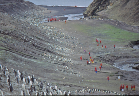
Vista from the top of Paulet Island, February 1994. Note the ship off shore of the island and the whitish areas on the beach. These whitish areas are all penguins - there are up to 20,000 nesting pairs in this view.

Chinstrap penguins at Bailey Head, Deception Island in 1994. This is a class 5.9 landing and not often attempted but well worth the effort.

Patterns in penguin rookery, Bailey Head, Deception Island.

Penguins are often the initial attraction for people to Antarctica but the landscape soon takes over. It will be my pleasure to share some of the spectacular scenes from this icy wonderland such as this scene from Charlotte Bay. The mountains here rise 3,000 feet from the shoreline (bottom) and are draped in about five hundred feet of ice and crevasse. Till the next time, cheers.

Saturday, December 12, 2015

Geology Guide Training in a Geologic Paradise - Las Vegas, Nevada

Most folks who work in the great outdoors often view Las Vegas as a place to be avoided at all costs. It is often thought of as a slovenly, loathsome place where night owls crawl around looking for a quick buck. For sure, there is that side to "Sin City." But the location of Las Vegas is anything but loathsome, rather it is a landscape paradise. I was fortunate recently to be asked to give geology training to a group of guides who work for Pink Jeeps Las Vegas. You may know this company from its uniquely painted 4X4 jeeps around the Sedona area but they also have operations in Scottsdale and Grand Canyon. Take a look at some of the nearby features we learned about in the Red Rocks National Conservation Area and Valley of Fire State Park.

Red Rocks National Conservation Area


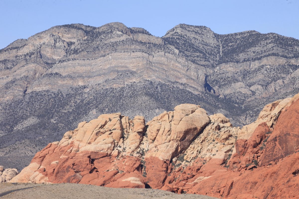
The Red Rocks area is situated to the west of Las Vegas in the Spring Mountains. I took this shot from the 24th floor of our hotel room looking west. Here, Jurassic-age Aztec Sandstone is overlain by the Cambrian Bonanza King Formation. This relationship is due to Sevier-age thrust faulting in the Western Cordillera between about 150 and 80 Ma.

 
Another 24th-floor shot but a bit farther south where a ridge of Kaibab Limestone in the forefront of the mountains partially blocks the view of the Aztec Sandstone. This ridge is generally in place and protrudes upwards to the east on the local dip.


The Aztec Sandstone from the Calico view area. The Aztec is a time equivalent of the Navajo Sandstone on the Colorado Plateau and the Nugget Sandstone in the central and northern Rockies. It was deposited in an eolian dune environment.


Much alluvium can be found at the mountain front and is dominantly composed of the early Paleozoic limestone class. Note that since the fan went inactive, it has been dissected down about 150 feet.


Great view of the thrust relationship between the older limestone rocks (grey background) which now sit above the younger red sandstone. The block that moved on the thrust was transported some 40 miles! Remember that this deformation occurred when these rocks were buried perhaps by a few miles of overlying material. Only the recent period of erosion has exposed what is seen here.


Paiute Indians once inhabited the area and this mescal pit attests to their presence here at Willow Springs.


The Aztec Sandstone has been flooded by subterranean fluids which leached iron staining off the individual sand grains. The transported iron was concentrated in other areas of the sandstone, giving the rocks a variable color.


Contact between the Aztec Sandstone above with the underlying Kayenta or Chinle formation (reddish slope). Both names have been used in this area.


Guides on our day trip to RRNCA include Chris D., Chris B., Jim C., and Debbie S. It was a great day.

Valley of Fire State Park


Sunrise from the 24th floor over Las Vegas. From here we drove north in I-15 to Valley of Fire State Park.


Walking in a slot canyon through the Aztec Sandstone.


Within the slot canyon are these fractures, infilled with harder cement material, likely silica cement. (NOTE: I RECEIVED A CORRECTION FROM Lu ZV THAT THESE ARE: deformation bands or granulation seams, that form from the rearrangement and/or crushing of the sandstone grains in response to tectonic stresses).


Nice textures in the sandstone.


Farther on, we see a Cretaceous age conglomerate. This package of sediment, which sits on top of the Aztec Sandstone was derived from the west in front of the Muddy Mountains thrust sheet. Thus this is a syn-tectonic deposit laid down during Sevier mountain building.


Close-up with a large class of Aztec Sandstone within it.
.

On the way out, we noticed offset fracture fillings along a cross-bedded plane. (NOTE: I RECEIVED A CORRECTION FROM Lu ZV THAT THESE ARE: deformation bands or granulation seams, that form from the rearrangement and/or crushing of the sandstone grains in response to tectonic stresses).


Fantastic offset of fractures along a cross-bedded plane.


Differential coloring between fractures. Whoa!


At Atlatl Rock, we see darker colored Aztec Sandstone with numerous rock art elements.


Close-up at Atlatl rock.


WooHoo!


Lichen train in a pour-off. The lichens preferentially grows where the water runs down.


Rock art


Las Vegas is known for its human element but nearby is another world centered in nature and as rewarding as any Southwestern locale.


Why not?

Lake Mead National Recreation Area


Lake Mead NRA recently updated their official park brochure. Inside there were a few surprises.


First off, the map portion of the brochure reflects reality of the reservoir level. The shoreline is drawn with respect to the recent drought. Note how far the roads are from reservoir - this is the lower pool elevation. Thus, the drought has been institutionalized on park literature.


Who would have ever thought that the image and sayings of Edward Abbey would show up on a park brochure for a National Recreation Area formed by a dam! This is milestone and reflects changing attitudes in the Southwest. My thanks to the guides at Pink Jeeps - Las Vegas for inviting to come to their little slice of paradise and share in some of their geologic gems.

Sunday, November 29, 2015

Rotorua Geothermal Area, North Island

There were just two more stops on this Smithsonian Journeys trip to Australia and New Zealand and both were on the North Island.. I had not previously been to the North Island so I was curious to see just how different it was from the South.

Leaving Queenstown we got a great view of Lake Wakatipu. At 50 miles long, it is New Zealand's longest lake and one of the deepest at 1,250 feet. The mountains around the lake (center) are known as The Remarkables.

These are the Canterbury Plains south of Christchurch, one of the largest growing regions in the country.

The mountains seemed endless on this flight! One usually thinks of New Zealand as a small place but the topography actually makes it a very big place. This is the Kaikoura Range with a maximum elevation of 9,465 feet on Mt. Tapuaenuku.

This is the Marlborough Sound in the extreme northeast corner of the South Island. Note the clear-cut logging occurring on the lower slopes of the peninsula.

This is the Cook Strait located between the North and South islands

While flying over the Cook Strait, I could look ahead to the west and see the Egmont volcano, now known by its local Maori name of Mt. Taranaki. Note the parasitic cone on its left (south) flank known as Fanthanms Peak, This beautiful strato-volcano is one of the most symmetrical in all the world and began forming some 135,000 years ago with its last eruption in the 1850's. See a good article on the volcano here and look at the unusual national park boundary around the cone here.

I was sitting on the correct side of the airplane because next in view was the Ruapehu volcano. Note the blue crater lake on its crest. A lot of geologic information about this cone can be found here on the Volcano Discovery web site.

Just north of Ruapehu is Ngauruhoe volcano

And just north again is the Blue Lake (bottom). What a spectacular geologic flight this was! I will have to come back and check these out on the ground one day.

After landing in Rotorua, we walked through a memorial grove of California redwood trees that were planted in 1901 to replace the native forest that was being cut for agriculture. The trees have grown quite large in this humid environment in their 114 years - see the person at the base of the left hand tree.

Although not as tall was the redwoods, the tree ferns were also spectacular

The Maori have opened a cultural park around the Te Puia geothermal area, just four miles from the city center of Rotorua.

Many aspects of Maori culture are on display here including wood carving, fabric making, geothermal cooking, and crafts.

This is the Pohutu geyser which is in constant eruption! It never stops.

Boiling mud pots on the way to the geyser can be seen and are always a fan favorite in geothermal areas.

Closer view of Pohutu geyser

Close-up view

That evening, we enjoyed a meal that was cooked in the ground in the traditional Maori way. Here the chefs are removing the food from the underground oven.

This is the former bath house in Rotorua, now the main museum in town. It has excellent exhibits which are a must-see when in Rotorua. Well done!

View of the sulphur bay on Lake Rotorua from the roof of the museum

Lake Rotorua sits within the caldera of the same name. This 14-mile diameter depression was formed about 240,000 years ago when a volcano lots its top and the region sank on top of an empty magma chamber. The activity is not over but there has not been an eruption here since about 25,000 years ago. All of these feature are part of the Taupo Volcanic Zone.

Black swan on Lake Rotorua

Rotorua has numerous examples of toon trees, which have been introduced from China. We were here just in time to see the leaves before they turn green.

I liked this view seen upon entering the Maori village of Ohinemutu in Rotorua. A Maori icon set against the European steeple of a church.

This is the front side of the Maori icon. Note the tongue distended with wide eyes, a typical Maori show of strength.