Way back in June, 2010 when the World Cup was in full swing in South Africa, myself and other geologists were participating in interviews on the rim of the Grand Canyon with a film crew from National Geographic TV. The production is titled "Birth of the Grand Canyon" and made its debut February 24 on the Nat Geo television channel. I haven't seen it yet but many viewers tell me it was well done and clearly presented. You can view a short trailer of the film here.
Rebecca Flowers
Carol Hill
Featured in the production are colleagues Ron Blakey (paleomap creator), Carol Hill (karst researcher), Rebecca Flowers (thermochronologic researcher), Karl Karlstrom (field geologist), and many others including myself. It is nice to see the science of geology and the Grand Canyon displayed so prominently on the tube. I hope you'll be able to catch the show. It will be running many times through out the years. Check the natgeotv.com and search for Naked Science.
Adventure and foreign travel, philosophical and scientific musings, geology and landscapes, photography and earthly explorations.
Friday, February 25, 2011
Wednesday, February 23, 2011
Searching the Origins of the Esplanade Platform in Grand Canyon
Far away from the main tourist areas in Grand Canyon lies a huge wilderness of stone and space. It is silent beyond belief and seldom visited. Within this huge expanse lies the Esplanade Platform, a stunning landscape feature that is found only in the central and western portions of the canyon. The Esplanade forms a broad terrace positioned about a fourth of the way down in the canyon, where the Hermit Formation overlies the Esplanade Sandstone. The Esplanade thus creates a canyon within a canyon. Geologists have long been intrigued by the presence of the Esplanade Platform in Grand Canyon and many theories have been proposed to explain its origin. Did the Colorado River carve it during a period of erosional quiescence, as some say? Or did it form in response to the canyon's variable stratigraphy? I explored these questions on a recent trip to the Esplanade. From February 10 to 16 I was privileged to backpack with two other friends here. This is our story.
The trailhead is located in the Grand Canyon. A poor road leads to the boundary of the Kanab Creek Wilderness, administered by the BLM. Here we parked our car to begin our journey. You can see tumbleweeds piled against the boundary fence of the wilderness area on the right side of this photo. We had no idea at this point what wonders awaited us.
This is the canyon we walked down to access the wilderness. The lower red slopes are cut into the Hermit Formation, a rock unit that plays an important role in the development of the Esplanade.
At the start of our hike we immediately became aware of the great space we would be experiencing on this trip. Usually a backpack into the Grand Canyon is a trip into the "womb of Mother Earth," with the high cliffs closing in tightly all around. But travel on the Esplanade is different. You can see far and the promenade makes for some exhilarating views.
But make no mistake about it - this is very far away from everything human. Any misstep or fall that would lead to an injury would require someone to backtrack out again many days walk to the trailhead, then to fetch help as quickly as possible. A trip out here is to place yourself in the hands of fate, come what may.
Here Frank R. walks up a slope in the Esplanade Sandstone. You can see the cross-bedding evident in the many shadowed lines. The Esplanade is the first deposit in the canyon of Permian age and was laid down in a dune field about 290 Ma (million years ago). I include a paleogeographic map of the Esplanade Ss. below to show the geography of the Grand Canyon region at this time.
Esplanade Sandstone time in the American Southwest at 290 Ma. Note the faint outlines of the Four Corner states in this image. The yellowish pattern denotes sand dunes in the ancient landscape and the small red line in northern Arizona represents the 55 miles that we walked in the seven days of backpacking.
Even though we had bright sunshine for all but the last day of our hike, ice was still present in the many side drainages we passed that never receive sun this time of the year. They formed some spectacular icefalls on the Esplanade.
Frank taking notes on the Esplanade with Jump Up Point visible in the far distance.
The Esplanade forms many beautiful overhangs and we walked past many of them in our seven days. Note the pile of gray rubble on the floor of this one, which signifies a place where ancestral people once roasted agave. Although it felt like we were the only people in all of Grand Canyon on this hike, evidence like this reminded us that we were not the first ones here.
Some of the overhangs were extreme and formed cave like entrances that framed the canyon beyond.
And we utilized many overhangs for sleeping, as the temperatures at night dropped into the 20's. Sleeping in an overhang could make a 10 degree difference on the warm side!
In this wilderness adventure, our only source of water was from potholes that had been replenished from the late December snow storms that swept across northern Arizona. We estimated that 90% of the potholes were already dry from the extremely dry conditions that persisted in January after these storms. We had to hunt occasionally for potholes with water.
So, what about the Esplanade? Why is there such a broad platform within the canyon at this level? Look at this view of the upper 1/4th of the canyon and note that the Hermit Formation is barely visible, being covered in talus or colluvium from above. This strongly suggests that it is erosional retreat of the Hermit Formation that undercuts the overlying rocks, causing them to collapse and bury the Hermit in the collapsed debris. Note the more recent rivulets that have been etched into this debris apron (center) and a lot more of this recent erosion into the apron on the far right side of the slope. We can imagine that the apron of debris was once more extensive and "smoother" across this view.
In this view you can also see what used to be a continuous apron of talus covering the Hermit Formation, until it was partially eroded by runoff off of the upper cliff. It is likely that the aprons of talus formed during the Ice Age (pre-10,000 years ago) when conditions were much wetter in northern Arizona and the American Southwest. The dissection and partial removal of the talus aprons most likely has commenced in the last 10,000 years. So another question presents itself - what drives the retreat of the Hermit Formation (and the generation of talus) and what causes the non-retreat of the Hermit Fm. and the partial destruction of the talus aprons?
First, the episodic nature of talus creation and removal can be seen in the many talus remnants that are perched today as isolated remnants on the Esplanade. Here, Bryan B. stands in front of one huge remnant which is seen in the middle distance as a whitish-capped surface that slopes to the right, well below the canyon rim. This isolated remnant of upper cliff material used to be connected to a talus slope that once covered the Hermit Fm., well before it was stripped back to its present position.
And here, I am standing in front of another smaller remnant in the right background. These old remnants definitely show that the creation of talus and its ultimate destruction is episodic in nature.
In modern Grand Canyon, many springs are developed at the contact between the red Hermit Fm. and overlying white Coconino Sandstone, marvelously visible here where the talus cone has been recently eroded. We can imagine that during the wetter conditions of the Ice Age, spring discharge was much greater at this contact. This increase in discharge is likely what caused the Hermit Fm. to retreat rather rapidly, and thus undercut the cliff above it, thereby causing the creation of an extensive talus apron. When the Ice Age ended, the springs dried up, the retreat of the Hermit Fm. was arrested, and the talus cones began to be eroded like we see in the photo above. Thus, the remnant talus deposits that are curiously scattered across the Esplanade may show the rather recent development of the Esplanade Platform. In my observations, the Colorado River in ancient times had nothing to do with forming the Esplanade, it developed "locally" through fits and starts during Ice Age glacials and the intervening interglacials.
Within the talus debris that litters the Esplanade, we observed many great fossils in boulders of the Kaibab Limestone. Here are some well preserved crinoids we found one day on our hike.
And here is a fossil sponge also preserved in the a block of the Kaibab.
Walking on the Esplanade. There was very little trail in this stretch of the hike and only well-experienced Grand Canyon hikers should attempt to enter these remote locations. The possibility to get lost or sustain an injury is great.
But the scenery was fantastic. Here Bryan and Frank ponder a rock sentinel.
Our route took on a platform that is extremely untraveled in the Grand Canyon, the top of the Redwall Limestone. This surface is not well-developed in most parts of the canyon and does not have a name at all like the Tonto or Esplanade platforms.
But we enjoyed this tramp across the surface of the huge Redwall cliff.
Back on top of the Esplanade, I noticed some well-developed channels that are cut into the Esplanade Sandstone and filled with deposits of the Hermit Formation. These channels would have been features on earth;s surface some 285 Ma, when the lower part of the Hermit was laid down across the lithified dunes of the Esplanade Sandstone.
Here is the same photo with some guides to show you these very subtle features. It is likely that the Esplanade Ss. was already a rock when the channel was cut into its top surface. Then fluvial mud was washed into the channel.
Here is a close-up of the same channel above.
And a look at one other channel I took a photo of. This one might be a bit easier to see to the untrained eye.
Our hike was a glorious success. No one was injured, we found water when and where we needed it, and we lucked out beating a huge snow storm that blew in just as we were leaving. But more than that, we experienced the Grand Canyon on a very personal level. Bryan and Frank were excellent backpacking companions and I am lucky to have friends so dear and willing to undertake such an adventure. Geology was also my constant companion on this hike and I cannot imagine not being aware of its overriding presence everywhere upon this landscape. If you would like to experience the marvels of the Esplanade Platform in Grand Canyon, you can take a much more accessible backpack on the South Bass Trail, or drive out to Toroweap Overlook on the North Rim.
Monday, January 31, 2011
A Look at the Marcus Landslide in the McDowell Mountains of Arizona
For those aware of the special appeal in "seeing" long-gone events and the power of geologic observation in resurrecting such events, the Marcus landslide is a truly wonderful story. Imagine being a young geology student out on a spring field trip with your professors and other researchers. The day drags on as a few of the "big-wigs" co-opt an otherwise valued discussion, endlessly debating some arcane or miniscule detail. Predictably, you wander off away from the group with your best friend and ultimately stop to enjoy lunch.
With the wide expanse of the Sonoran Desert as your backdrop, you suddenly look up and notice an unusual and vibrant concentration of golden brittlebush, back lit perfectly on the slopes of the McDowell Mountains outside Scottsdale, Arizona. Other parts of the range do not have this density of flowers and something appears unusual. You begin to also notice clusters of large granite boulders that seem to trend up the slope towards the colorful brittlebush. A lively exchange of ideas ensues and soon the light clicks on inside both of you - you have just detected the initial evidence for a giant Ice Age landslide that occurred here. No one else has ever seen this before!
Such is a description of how Brian Gootee and John Douglass discovered the Marcus landslide in 2002. (The feature was named in honor of the late Melvin Marcus Professor of Geography at ASU). Gootee (now with the Arizona Geological Survey) and Douglass (now a professor at Paradise Valley Community College) completed subsequent research on the evidence left by this humongous slope failure. Admittedly subtle at first, the evidence is convincing that something big happened here about 500,000 years ago.
I was fortunate to accompany my good friend Brian Gootee on a field trip to the Marcus landslide in January of this year. Accompanying us were his wife and duaghter, Rachel and Zoe, and my wife, Helen. Below are some of the photos I took on this glorious winter's day in the desert.
This is the east side of the McDowell Mountains looking south. Fortunately, this patch of desert is protected by the City of Scottsdale and Maricopa County in two nature preserves. The city and county are working closely with Brian Gootee to develop an interpretive trail to the slide.
A closer look to the south reveals a famous Arizona landmark in the Superstition Mountains - Weavers Needle. According to legend, the Lost Dutchman's gold mine was located within sight of this feature, meaning that the treasure could lie among the boulders in this slide. However, most of the people who believe in this legend scratch and scour the Superstition area.
As we hiked to the south we began to see the slope of the collapsed debris pile. You can see it in the middle distance between the sunlit foreground and the shaded slope of the mountain range.
Helen listens to Brian as he gives an excellent description of the features present and the sequence of observations that led him and colleague John Douglass to the conclusion that a giant slide mass is present here.
These are some of the granite boulders that are located on the north levee of the slide. This material likely originated high up on the slopes of the McDowell Mountain in a rock failure that was activated along joints (fractures) in the granite. It was then entrained with other smaller grained components into a debris flow that traveled almost one mile in length and 1/3 of a mile in width.
Detailed mapping has shown that the tilted boulder (above) is part of the slide material, but the granite it rests on is in place and not part of the slide. The evidence will be shown below.
Looking southeast across the Marcus landslide towards the Superstition Mountains.
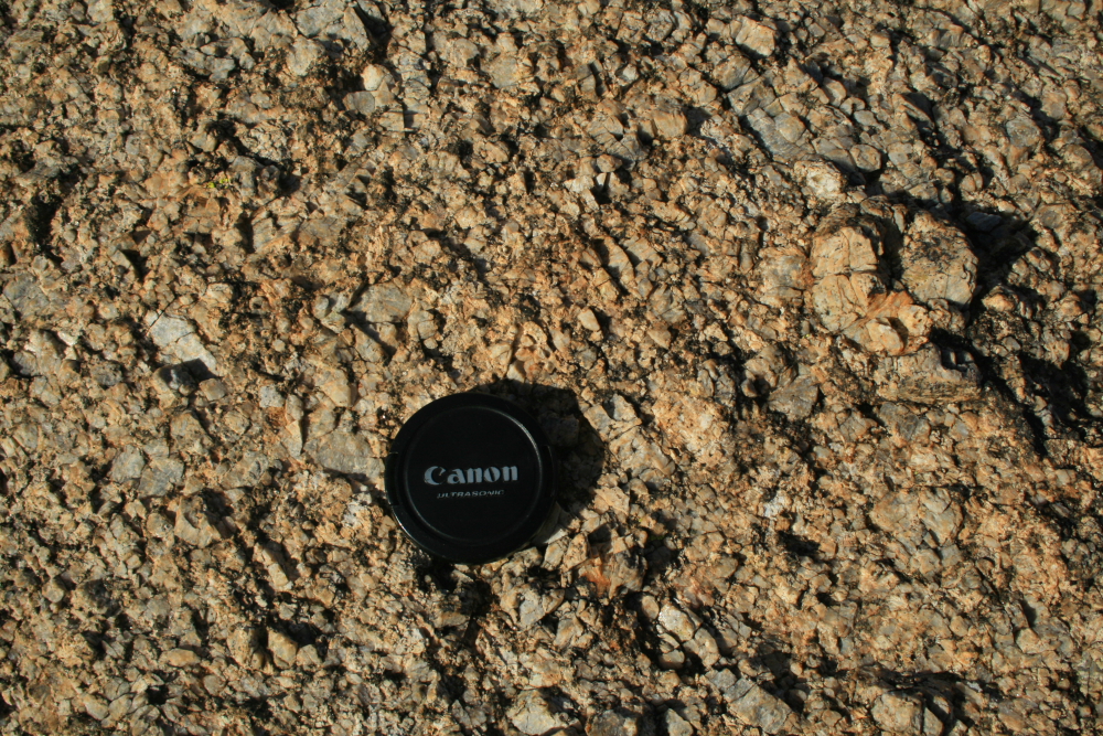
Here is a close-up (with lens cap for scale) of the clay and sand size material that makes up the matrix of the slide mass. As it came down the slope of the McDowell's, at an estimated speed of 16 to 44 miles per hour, the huge boulders would have been "cushioned" by this fine material.
Here is a view of the eastern terminus of the slide. Note that the boulders are not found farther out in the valley and outboard of the slide front. One of the boulders at this location is where Gootee and Douglass shared lunch on a field trip in the spring of 2002 and first pondered the possibility of a huge slide here. And if you are still wondering what the heck "an unusual concentration of brittlebush flowers" had to do with their discovery, note that the scar left on the side of the mountain front from the slide left the perfect substrate for the enhanced growth of brittlebush. They just happened to be in the right place at the right time of day and year!
Here is a close-up of the mega-crystic granite that forms the backbone of the McDowell Mountains and was caught up in the Marcus landslide. The quartz crystals are quite durable chemically but the feldspars weather more rapidly and certainly helped to facilitate the slide. Remember, this all happened just prior to 500,000 years ago (a date based on rock varnish micro-laminations) during the Ice Age, when Arizona was much wetter and cooler. These conditions certainly played a big role in the development of the slide.
How did Gootee and Douglass determine what granite was involved in the slide and what granite remained in place as bedrock. Look closely at the granite above and notice that the upper boulder has no joints in it, while the lower granite has at least three joints running through it. As the granite came down the slope catastrophically, it would have broken into its constituent pieces along joints. So the material arrived here already "chopped up". The lower granite wasn't involved in the slide and so still shows its obvious jointed nature.
A nice view of the slide front to the south - it is highlighted by the shade of the late afternoon sun. The timing of my visit did not allow for me to take pictures of the pocket or headwall area of the slide up in the mountains - it was looking right into the late afternoon sun.
![]() |
| Image courtesy of AZGS |
Such is a description of how Brian Gootee and John Douglass discovered the Marcus landslide in 2002. (The feature was named in honor of the late Melvin Marcus Professor of Geography at ASU). Gootee (now with the Arizona Geological Survey) and Douglass (now a professor at Paradise Valley Community College) completed subsequent research on the evidence left by this humongous slope failure. Admittedly subtle at first, the evidence is convincing that something big happened here about 500,000 years ago.
![]() |
| Aerial view of the Marcus landslide (AZGS) |
![]() | |
| View of the east side of the McDowell Mts. | (AZGS) |
![]() | ||
| Digital elevation image of the slide (AZGS) |
I was fortunate to accompany my good friend Brian Gootee on a field trip to the Marcus landslide in January of this year. Accompanying us were his wife and duaghter, Rachel and Zoe, and my wife, Helen. Below are some of the photos I took on this glorious winter's day in the desert.
This is the east side of the McDowell Mountains looking south. Fortunately, this patch of desert is protected by the City of Scottsdale and Maricopa County in two nature preserves. The city and county are working closely with Brian Gootee to develop an interpretive trail to the slide.
A closer look to the south reveals a famous Arizona landmark in the Superstition Mountains - Weavers Needle. According to legend, the Lost Dutchman's gold mine was located within sight of this feature, meaning that the treasure could lie among the boulders in this slide. However, most of the people who believe in this legend scratch and scour the Superstition area.
As we hiked to the south we began to see the slope of the collapsed debris pile. You can see it in the middle distance between the sunlit foreground and the shaded slope of the mountain range.
Helen listens to Brian as he gives an excellent description of the features present and the sequence of observations that led him and colleague John Douglass to the conclusion that a giant slide mass is present here.
These are some of the granite boulders that are located on the north levee of the slide. This material likely originated high up on the slopes of the McDowell Mountain in a rock failure that was activated along joints (fractures) in the granite. It was then entrained with other smaller grained components into a debris flow that traveled almost one mile in length and 1/3 of a mile in width.
Detailed mapping has shown that the tilted boulder (above) is part of the slide material, but the granite it rests on is in place and not part of the slide. The evidence will be shown below.
Looking southeast across the Marcus landslide towards the Superstition Mountains.
Here is a close-up (with lens cap for scale) of the clay and sand size material that makes up the matrix of the slide mass. As it came down the slope of the McDowell's, at an estimated speed of 16 to 44 miles per hour, the huge boulders would have been "cushioned" by this fine material.
Here is a view of the eastern terminus of the slide. Note that the boulders are not found farther out in the valley and outboard of the slide front. One of the boulders at this location is where Gootee and Douglass shared lunch on a field trip in the spring of 2002 and first pondered the possibility of a huge slide here. And if you are still wondering what the heck "an unusual concentration of brittlebush flowers" had to do with their discovery, note that the scar left on the side of the mountain front from the slide left the perfect substrate for the enhanced growth of brittlebush. They just happened to be in the right place at the right time of day and year!
Here is a close-up of the mega-crystic granite that forms the backbone of the McDowell Mountains and was caught up in the Marcus landslide. The quartz crystals are quite durable chemically but the feldspars weather more rapidly and certainly helped to facilitate the slide. Remember, this all happened just prior to 500,000 years ago (a date based on rock varnish micro-laminations) during the Ice Age, when Arizona was much wetter and cooler. These conditions certainly played a big role in the development of the slide.
How did Gootee and Douglass determine what granite was involved in the slide and what granite remained in place as bedrock. Look closely at the granite above and notice that the upper boulder has no joints in it, while the lower granite has at least three joints running through it. As the granite came down the slope catastrophically, it would have broken into its constituent pieces along joints. So the material arrived here already "chopped up". The lower granite wasn't involved in the slide and so still shows its obvious jointed nature.
A nice view of the slide front to the south - it is highlighted by the shade of the late afternoon sun. The timing of my visit did not allow for me to take pictures of the pocket or headwall area of the slide up in the mountains - it was looking right into the late afternoon sun.
A zoom view of the immense fountain in Fountain Hills, which can be seen during the first 15 minutes of every hour.
Please read Brian Gootee's official description of the Marcus landslide here on the AZGS official web site. You can also go on a virtual field trip to the slide on John Douglass' web site here. I can highly recommend both sites to learn more about this fascinating discovery.
If you would like to visit the Marcus landslide be aware that there are no signs yet, nor official trails to it. Use your ingenuity to find the trails on the east side of the McDowell Mountains that approach Tom's Thumb. Walk south from there and keep your eyes open for a train of debris that looks anomalously strange.
Tuesday, January 18, 2011
Amazing Photo's and Video of the April 4, 2010 Earthquake Near Mexicali
You've likely heard (and perhaps forgot) of the 7.2 magnitude earthquake on April 4, 2010 that occurred near Mexicali, Baja California.
Recently, a friend forwarded some amazing photo's that were taken just as the rupture occurred. The oft-forwarded e-mail stated that the photos were taken by a California Highway Patrol officer, but these were clearly taken within Mexico by someone else. Lee Allison, colleague and Arizona State Geologist reports that they were taken by Danny Ashcraft.
The first set of photo's show the usual result of an earthquake - offsets and damage done to roads and bridges. But be sure to scroll all of the photos down to the end and see how a mountain range responds to the earth shaking. Amazing! You can also view a video clip of the earthquake, taken by the security camera at the Crown Plaza Hotel in Mexicali, here (sorry about the pre-video ad).
*** Added note: Chris Rowan, author of the blog Highly Allochthonous, made me aware of this YouTube video of the rising dust plumes on the Sierra Mayor. Check it out here. ***
The damage visible in this road appears to show some aspect of vertical offset to it (see the dirt portion adjacent to the road on the left). Most of the faults associated with the San Andreas system have lateral offsets but oblique offsets - those that combine vertical and horizontal displacement) can also occur.
In spite of the quake, folks appear to be having a great time seeing the results of our earth in motion.
If you look at the white line in the road that was offset by the quake (near the funny man in the fault trough), you'll notice that it contains both a vertical offset and a horizontal offset. Note that the horizontal offset is left-lateral - that is if you stand and look across the fault, the other side was moved to the left. The San Andreas is typically a right lateral fault but smaller subsidiary faults can accommodate spatial motions with different senses of offset.
A badly damaged section of road that looks as if it was shaking quite violently during the 45 seconds of motion. But the real interesting photos begin now......
This is the Sierra Mayor looking west from the Mexicali Valley. The epicenter of the quake is located somewhere in this range.
The shaking of the earth caused huge dust storms to emerge from the rocks in the mountain range.
A final look at the dust plumes from the Sierra Mayor earthquake last Easter Sunday. Studies of the San Andreas Fault by scientists at the US Geological Survey suggest that there is a 95% chance that a large rupture will occur on the system within the next 20 to 30 years. People who live in this area should remind themselves every day that they live next to one of the planets most seismic areas and prepare as best they can for a large shake.
Thanks to Glenn Rink of Flagstaff, Arizona for sending these photos along.
The first set of photo's show the usual result of an earthquake - offsets and damage done to roads and bridges. But be sure to scroll all of the photos down to the end and see how a mountain range responds to the earth shaking. Amazing! You can also view a video clip of the earthquake, taken by the security camera at the Crown Plaza Hotel in Mexicali, here (sorry about the pre-video ad).
*** Added note: Chris Rowan, author of the blog Highly Allochthonous, made me aware of this YouTube video of the rising dust plumes on the Sierra Mayor. Check it out here. ***
The damage visible in this road appears to show some aspect of vertical offset to it (see the dirt portion adjacent to the road on the left). Most of the faults associated with the San Andreas system have lateral offsets but oblique offsets - those that combine vertical and horizontal displacement) can also occur.
In spite of the quake, folks appear to be having a great time seeing the results of our earth in motion.
Here is a bridge that obviously shows that the photos were taken in Mexico - I crossed this bridge just a few weeks ago on my trip to Sonora. It makes me wonder, who makes up these stories in the many e-mails that are forwarded to us? Taken by a CHP officer - jeez!
If you look at the white line in the road that was offset by the quake (near the funny man in the fault trough), you'll notice that it contains both a vertical offset and a horizontal offset. Note that the horizontal offset is left-lateral - that is if you stand and look across the fault, the other side was moved to the left. The San Andreas is typically a right lateral fault but smaller subsidiary faults can accommodate spatial motions with different senses of offset.
A badly damaged section of road that looks as if it was shaking quite violently during the 45 seconds of motion. But the real interesting photos begin now......
This is the Sierra Mayor looking west from the Mexicali Valley. The epicenter of the quake is located somewhere in this range.
The shaking of the earth caused huge dust storms to emerge from the rocks in the mountain range.
It must have been quite a series of sensations to behold - first to feel the whole ground shake beneath your feet, then see large volumes of dust rise out of the nearby mountains. Earthquakes are attention grabbing events that remind us that the earth is alive! These lucky folks were able to experience this one without the fear of something toppling over and injuring (or worse, killing) them. An ideal spot to be on this Easter Sunday.
A final look at the dust plumes from the Sierra Mayor earthquake last Easter Sunday. Studies of the San Andreas Fault by scientists at the US Geological Survey suggest that there is a 95% chance that a large rupture will occur on the system within the next 20 to 30 years. People who live in this area should remind themselves every day that they live next to one of the planets most seismic areas and prepare as best they can for a large shake.
Thanks to Glenn Rink of Flagstaff, Arizona for sending these photos along.
Subscribe to:
Posts (Atom)