I love Santa Fe, New Mexico. So when I got the opportunity to present a
lecture on the Colorado River for
Southwest Seminars,
we took a few extra days to explore more of the area. My colleague, Kirt Kempter invited us along to see first hand the results of his pandemic project,
making a detailed map of a maar volcano to the southwest of the
city. These features form when magma interacts with groundwater to create a steam explosion, forming a shallow depression after the explosion. The depression can become filled with scoria (cinders) and lava flows, and sometimes a lava lake, which upon subsequent erosion can leave the post-maar volcanics standing in high relief. This is a difficult thing for beginners to understand since the maar formation creates a depression but the modern feature is a mountain (the infilling lavas are more resistant than the surrounding materials)
Santa Fe's historic Plaza is where the western terminus of the
Santa Fe Trail
is located. The wooden structure seen in the center of the Plaza here hides an
obelisk and plinth that was erected in 1867 to commemorate the perpetuation of
the Union after the Civil War. However, one side of the obelisk praised
"The heroes who have fallen in the various battles with savage Indians
in the territory of New Mexico." In 1974, the word "savage" was chiseled out by an unknown
person. On October 12, 2020, the obelisk was toppled and the city began a community conversation on the future of the
monument.
We always visit the small town of Chimayo where we buy our year's supply of red
and green chile powder. The Virgil Store shown here had a For Sale in front of
it - oh the horror!
At the Santuario de Chimayo.
On a nice sunny day, Kirt took us southwest of the city to the Diablo
volcano, where he has completed a detailed study of its history and mode of
formation. This is a view to the west looking downstream to Diablo Canyon, carved by the intermittent stream of Cañada Ancha.

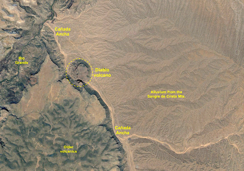
Google Earth image of the Santa Fe area. The city and the Sangre de Cristo
Mountains are on the right. The Cerros del Rio volcanic field and Diablo volcano
are on the left. In all of my visits to Santa Fe I never explored to the
southwest of the city. I had been east, north, south and west and was always
curious about the hills to the southwest of the city. I have also been intrigued for why Santa
Fe grew so far from the Rio Grande and on a relatively featureless alluvial plain at the foot of the
mountains. I always wondered why the Camino Real diverged from the course of the river to climb onto the alluvium (there was a pueblo village here of some importance). Nevertheless, what existed between the city and river? I soon found out.
Close-up of the Google Earth image. The broad alluvial plain is carved into the
Tesuque Formation and overlying Ancha Formation. Note that the Diablo volcano is
partially bisected by Cañada Ancha - a big part of this story that will be revealed below!
Beginning our trek up to the top of the volcano, located in the
Diablo Canyon Recreation Area. The location is popular with rock climbers who find the columnar joints in the walls of the gorge
inviting.
Along the way, volcanic bombs were strewn over the ground, documenting a
sub-aerial origin in this instance.
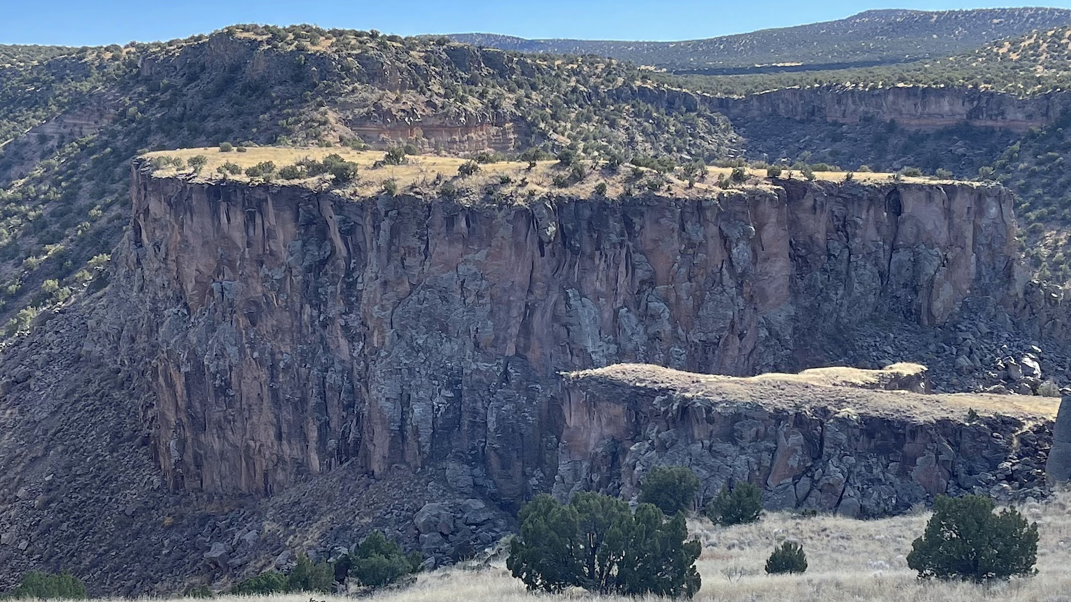
A view to the west of the Lengua del Diablo (Tongue of the Devil). Note the floor of Cañada Ancha on the far left and the Jemez Mountain and caldera on the horizon. The colorful rocks in the ridge of Lengua del Diablo are composed of tephra deposits from the maar explosion (the greenish, lower cliff formed by
phreatomagmatic processes), capped with dark basaltic lava, scoria and ash (photo center) that was erupted after the formation of the maar. Note the vertical dike within the phreatomagmatic deposit. This dike episode actually fed the flows on the uppermost part of the cliff. Within the phreatomagmatic deposit a very large blocks of the Tesuque Formation that were also thrown outwards from the steam blast. One of these large, pink-colored clasts can be seen at the base of the green cliff and left of the dike (partially hidden by a small juniper tree. An amazing exposure!
A large dike (center) intrudes through older scoria layers.
Complex interplay of maar tephra (golden color) and post-maar scoria and dikes.
A close-up of the previous photo showing the dark basalt dikes intruding the older tephra (golden).
View to the west from the top of the maar toward the Jemez Mountains and Chicoma Peak. Cañada Ancha is seen in the floor of the valley.
Panoramic view with Kirt Kempter pointing out features.
Another view of the Lengua del Diablo. After spending a few hours looking at the internal features of the volcano, I became curious about its eruptive setting. Kirt had explained that the age of the Cerros del Rio volcanic field is mostly constrained between 2.7 and 2.4 Ma, straddling the time boundary between the Pliocene and Pleistocene. Kirt further explained that the sequence of events went from initial phreatomagmatic eruptions that created a maar depression, which gave way to scoria cone formation and subsequent fluid lava flows and the formation of a lava lake. In the back of my mind, I kept thinking, "Why are we so high above the surrounding terrain? The answer of course, is that 2.5 million years ago, top of the maar was the floor of the valley and erosion of Diablo Canyon had not yet commenced.
And boy was this evident as we went to the lip of Diablo Canyon! Across Diablo Canyon and Cañada Ancha is a detached portion of a lava lake basalt that once filled the central maar. It has been separated from the foreground by incision of the stream. Thus, Diablo Canyon is approximately 2.5 Ma.
Close-up of the far-side mesa. Note the small rise on top of the mesa - this is composed of rounded cobbles and sand from Cañada Ancha when it was flowing on top of the lava lake. The stream had no idea that its course was on top of the edge of lava lake deposits and as it incised downward its course was not deflected away - superposition in action! How fortunate that these remnant cobbles are left on the high-standing mesa for this interpretation.
Diablo Canyon from the top looking southeast and upstream on the bed of Cañada Ancha. Spectacular.
Kirt with his dogs looking across the top of the maar volcano to the Sanger de Cristo Mountains.
Our group at the end of the hike - Helen, Kirt and John. Thank you Kirt for a great day and a wonderful field trip! Kirt will soon publish a paper on his work and I will add an addendum to this post when it is ready.


No comments:
Post a Comment
If your comment will not post, email me with the problem.