Leaving the Falkland Islands we sailed east into the Scotia Sea. The tectonic setting of this small plate is very interesting to the Antarctic traveler.
A slide used in my South Georgia lecturer shows the tectonic setting of the island of South Georgia. Note how South America and the Antarctic Peninsula both bend eastward, almost as if a hard wind is blowing in the Drake Passage. The bend is due to mantle flow from west to east that has disrupted a once continuous mountain chain linking the southern Andes with the Antarctic Peninsula. South Georgia is a continental fragment that was carried east in this breakup and the rocks there are similar to those exposed on the island of Tierra del Fuego. The Scotia plate is outlined in red with the north edge of plate forming the submarine Scotia ridge, and underwater cliff that will be featured in some of the photos below.

We sailed for nearly 40 hours before sighting any land and the first seen was six knobs called the Shag Rocks (a shag is a type of cormorant). These rocks are the only emergent portion of another continental fragment called the Shag Rocks block. Like South Georgia, this is a shattered fragment of continental crust that was "blown" eastward when mantle flow beneath the crust here caused the breakup.
A closer view of Shag Rocks. There were thousands of seabirds flying and nesting in the area. Coming upon such remote landscapes is always a thrill.
A little further east, we sailed over the Scotia ridge which marks the tectonic boundary between the Atlantic and Scotia plates. The ridge forces cold, Antarctic water toward the surface which causes high productivity in the sea. It was while sailing over the ridge that we saw between 50 and 200 humpback whales feeding on the krill and other life that was being upwelled here along the ridge.
Everywhere we looked there were humpback whales (
Megaptera novaeangliae). I had never seen so many in one place before. It shows that the whaling stocks are making a good recovery since the end of commercial whaling in the mid-1960s.
Many seabirds were also taking advantage of the nutrient-rich waters hear.
We were treated to quite a show - and we hadn't even arrived yet at our destination.
Our first stop on South Georgia was Salisbury Plain, where over 60,000 pairs of King penguins (
Aptenodytes patagonicus) can be seen. Yes, those are penguins trailing back all the way up the slope in the right hand corner of the photo. These young chicks with their brown feathers are called oakum boys.
These are perhaps the most beautiful and regal penguins (hence the name) of all 17 species of penguin. Note the penguin in the foreground that is moulting.
I used this photo in one of my lecture slides, using the penguin for scale of the dike-riddled rock.
A young fur seal pup was very curious of my camera.
There is a 15 foot distance mandated for us to stay away from the penguins. But occasionally they will come closer to humans as they have no such regulation.
South Georgia is the best place to see the King penguin on an Antarctic voyage since they are a Sub-Antarctic species and would not be seen in Antarctica.
Our second day on this island would prove to have the best weather of our three day visit and this was the view from our cabin as we sailed into Stromness Bay.
About 40% of South Georgia is free from glacial ice and this is another significant difference from Antarctica.
Whalebones, fur seals, and a rainbow greeted us on our landing.
In the background is the Stromness whaling station, the place where Sir Ernest Shackleton and two of his men walked into after making a 36-hour land crossing from the south side of the island. They arrived to announce their much delayed return from two unexpected winters in Antarctica.
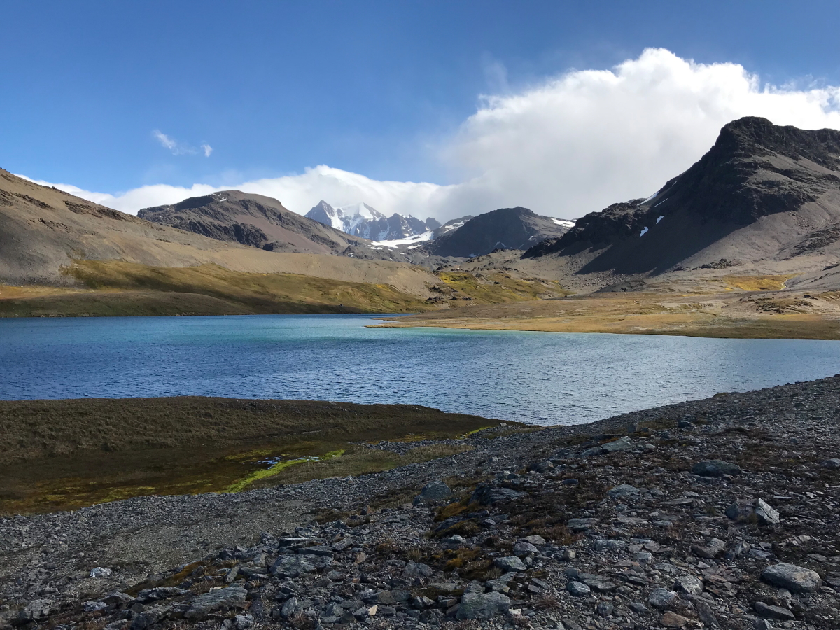
At the head of this valley is the Shackleton waterfall, the destination of our hike.
Looking back to the beach along the hike. Note our ship
Le Lyrial anchored in the background.
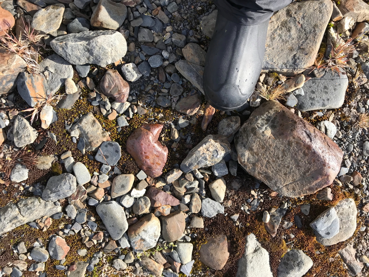
Outwash from the stream reveals fragments of rock types located higher up in the valley.
The skies began to clear for us - something a person can only hope for when visiting South Georgia. The weather is often very bad here and in fact, we were blown out from both of our activities schedule on our third and last day here.
In the afternoon we sailed into Cumberland Bay and got an excellent view of Mt. Paget (elev. 9,269') the highest peak on South Georgia. We were on our way to Grytviken, another important whaling station and the administrative capital of South Georgia.
Giant, Southern elephant seals
(Mirounga leonina) greeted us on the beach. They come ashore during the day after feeding at night. They are prolific divers and seals that have been fitted with tracking collars are known to have routinely dived between 1,000 and 3,300 feet. One individual went down 7,000 feet on one dive.
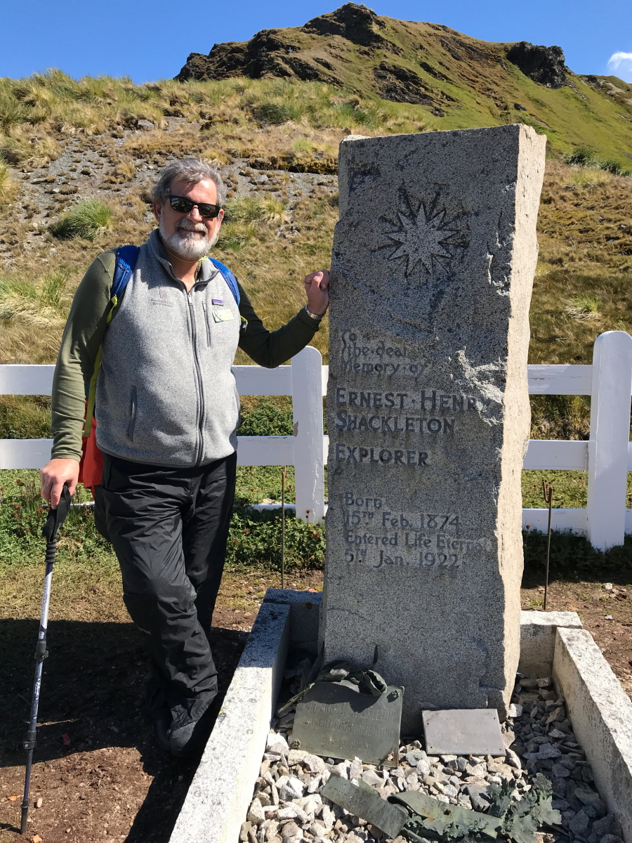
One of the highlights in stopping at Grytviken is to visit the small cemetery.
This is where Sir Ernest Shackleton is buried. He had returned to South Georgia for another Antarctic adventure when he suffered a heart attack and died. His remains were brought back to Uruguay with the intention of returning to the UK. But his wife said 'never mind' - he belongs down there. And so he was returned to South Georgia for burial. It is a highlight for most travelers to visit his grave.
The previous visit in 2016 was a gray, rainy day and this was a much welcomed change.
There was some work being carried out on the grave.
Workers repairing the surround stones.
The famous
Frank Wild, Shackleton's Second-In-Command on the 1914-16 expedition is also buried in the cemetery. He died and was cremated in South Africa. But in 2011 his remains were placed next to Shackleton's here at Grytviken.
What a lovely day for a walk! If South Georgia had more weather like this it would certainly be a more heavily visited destination. Only about 1/4 of Antarctic voyages come to South Georgia, meaning there are only about 10,000 visitors per year. Only a small fraction of those see skies like this.
View inland from the top of the hike.
View of
Grytviken whaling station and King Edward Point, where the British ship the James Ross is docked.
Walking back to the station.
This is the Petrel, one of the whaling ships that worked out of Note its harpoon gun still mounted on the bow.
This is the flensing area, where the whale carcasses were winched up to to be butchered. It is almost criminal to think today of commercial whaling at this scale, especially after seeing the feeding frenzy earlier in the trip along the Scotia ridge.
Anchor chains lying in repose. There has been an incredible amount of clean-up that has occurred here since my first visit in 1992.
The Norwegian whalers church has been completely restored.
Inside of the church.
A plaque to Frank Wild is also on the wall in the church. Our last day in South Georgia was a complete washout with Beaufort force 10 winds and rain. We were unable to land at Gold Harbor or visit Drygalski Fjord. So we left early to get some extra time in Antarctica!


No comments:
Post a Comment
If your comment will not post, email me with the problem.