(By the way, the famous Aztec king, Moctezuma, never had anything to do with this area or its landforms. However, when Anglo pioneers first entered the Verde Valley in the 1870's they assumed that the many ruins found scattered throughout the valley must surely have something to do with the fabled leader. Although his true name was Moctezuma, that was apparently too hard of a sound to replicate and the name was corrupted to Montezuma).
 |
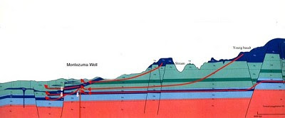
| Cross-section showing the flow path of groundwater from the Coconino Plateau and Mogollon Rim (upper right) through the Redwall aquifer (dark blue) to Montezuma Well (labeled) |
Ray Johnson, a hydrologist with the USGS, and Ed DeWitt, a geologist, completed their study and gave the series of public programs. Their official report will be released next month but you can read an excellent summary article in the Camp Verde Bugle by Steve Ayers here. Steve is a science writer who has the ability to capture the essence of a topic and make it understandable to regular folks. He has published many pertinent geology features in the Bugle through the years.
The study by Johnson and DeWitt states that the water in Montezuma Well originates as precipitation on the Coconino Plateau and travels a lengthy journey within rocks beneath the Mogollon Rim. This subsurface journey, which lasts up to 13,000 years before emerging in the bottom of the Well, is routed through the Redwall Limestone. The Redwall serves as a regional aquifer in northern Arizona and was laid down in a tropical sea some 340 million years ago.
 |
| Paleogeography of the Four Corner states at 340 million years ago when the Redwall Limestone was deposited. Figure from "Ancient Landscapes of the Colorado Plateau" by Blakey and Ranney |
Along the way, the groundwater dissolves some of the limestone, making the water calcium rich and creating carbon dioxide in the process. The water encounters a basaltic dike some 750 feet below the Well floor and this forces some of the water up to the surface. The evidence for the dike comes from tiny olivine crystals that are found in the Well sands. Olivine is a common mineral found in basalt.
This is an excellent study with many avenues available for public understanding. In my opinion, this is the best kind of science. I leave you with a quote about this from George Otis Smith, the director of the US Geological Survey in 1921:
"I am convinced that at its best, science is simple - that the simplest arrangement of facts that sets forth the truth, best deserves the the term science. So the geology I plead for is that which states facts in plain words - in language understood by the many rather than the few."
Fascinating! My cousins inherited (then much later sold) a well drilling business from their father. I'm sure they would understand this much better than I, but it is interesting to learn a little about the reasons that things are they way they are.
ReplyDelete