Many of you will remember a hike I completed last October in southern Utah (
link here). This year, a similar group of friends went into Grand Gulch, a marvelous little canyon located on Cedar Mesa. You can access the BLM web site for Grand Gulch
here.
I am including many photos from this six-day hike but little details on specific locations. A hike in Grand Gulch requires knowledge of changing conditions, stamina, and proper gear. It is a long ways away from help. But for those who are prepared, look at what can be found here.
Some of the pictures are artistic or scenic, some are geologic with explanations, and many are archaeologic. I hope you enjoy this gallery of photos.
Camping at the trailhead and looking north to the Bears Ears, one of the most widely-seen landforms in this part of the Colorado Plateau. Lower slopes composed of the Chinle Formation with cap rock of Wingate Sandstone.
Sunset
Trailhead view to west with the Henry Mountains in the background
Chuck L. heading out to the canyon's edge
And looking down into Grand Gulch
Losts of cottonwood trees and ruins along this stretch
Admiring the Big Man panel
Closer view
Close view
Grand Gulch is a winding canyon that stretches some 60 miles from Elk Ridge to the San Juan River. Within the canyon are many
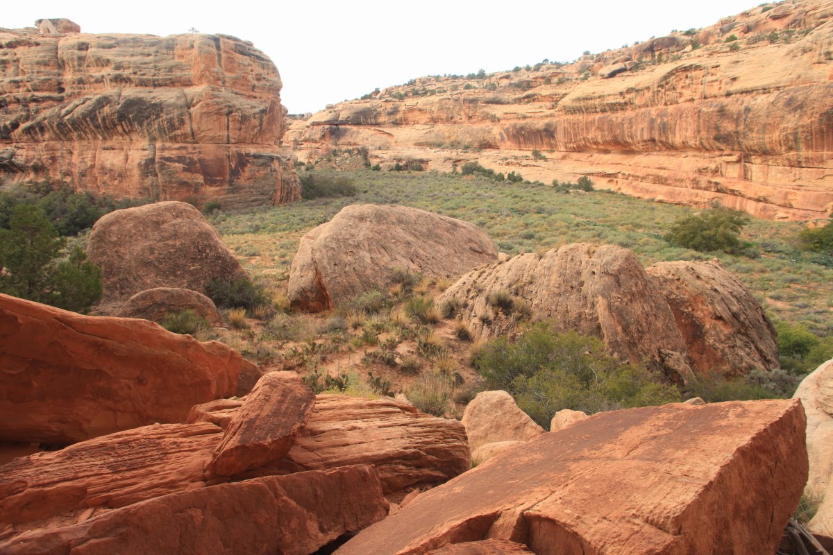
cut-off meanders (also known by their Spanish equivalent of rincon). Some of the cut-off meanders are older and thus perched higher within the canyon. Others were more recent and the cut-off bed was very close to modern stream level. This was one of the first ones we saw near Polly's Canyon.
Grand Gulch is known for its many hand prints rock art
And bird morphs
Many floods have come down the stream this monsoon season and fresh mud was everywhere beginning to dry out and form mud curls
Ancient cracks filled with sediment - the Cedar Mesa Sandstone has some great bedforms
Inaccessible ruin near the top of Polly's Island
A view of Wrong Side Ruin looking upstream on Grand Gulch
View of a collapsed structure with roof beams still present. The age of the ruins is approximately 800 years but some of the rock art is twice as old or older.
Secondary storage room
A portion of the Train panel
This is the bed of Grand Gulch at one of the pour-offs. These form when a meander is abandoned and the stream then flows through the "gooseneck." Since the downstream side of the gooseneck is lower than the upstream side, a pour-off or knick-point will be present in the streambed until enough erosion levels it out.
Some parts of the hike were easy, others were like walking through a jungle of riverside vegetation or boulder fields. It was not an easy hike.
Ruin
Dogweed flowers
Bannister ruin is well named
While the others took the creek bed, I went high to cut off a curve in the stream
It rained once on our trip and we were in our tents for the full 6 hours of rain, associated with Hurricane Simon
Joe and Norm relax
Bryan and George
Looking ahead, one can see and island in a cut-off meander. This one would prove quite interesting.
Cut-off portion of the old channel to the left but the present-day creek turns right
Up in this rincon we observed interesting fine-grained sediments. They looked to me on first view like lake deposits. One can imagine a giant rockfall somewhere downstream that chocked the channel of Grand Gulch. Then the water began to back up into the canyon, leaving deposits on its floor. The lake water may have spilled over the gooseneck and when the rockfall was removed downstream, the water took the shorter route, abandoning this bend.
Kokopelli
Another slice through a gooseneck, this one known as The Narrows
Close-up of The Narrows
Much of the rock art here had happy themes - people holding hands or waving. It seems like this might have been a happy place for its inhabitants.
Limestone boulders in a sea of red sandstone. In the shady mornings, these looked blue in color.
Datura blooming
A panel called 1,000 Hands
Nearby anthropomorphs (human-like figures)
As rough as the hiking was, it was downright beautiful in some sections
Spring water at an unnamed side canyon
Waving figures
Adorned anthropomorphs
The ubiquitous Bighorn sheep
More waving anthropomorphs at the Big panel
Chuck is a student and researcher of these ancient ones and his obvious pleasure is evident here.
George admiring a relatively rare glyph of ravens
Near Wetherill Cave
Green or blue figures are quite common here
Another view of Grand Gulch after the short storm passed
The Cedar Mesa Sandstone is composed of alternating beds of eolian sandstone and fluvial or near shore floodplain sandstone. The result is differential weathering that creates fantastic shapes.
Pools of summer run-off
An undercut cliff face and groves of cottonwood, willow and tamarisk
Grand Arch at sunset
Grand Arch at sunrise
Another cut-off meander. We likely saw 10 of these in 26 miles.
One last rincon
[These last two photos are not mine but were found on the Internet from other blogs]. As we approached the San Juan River, we dropped down into the Halgaito Shale and the gradient of the stream was increased. Here a 30-foot pour-off was encountered and we had to negotiate the loose rock on the left of the photo.
This is not our group but you can clearly see the hazards of this route. A dead deer was found at the base of the fall and we named this the Dead Deer Traverse. The San Juan River is only one half mile from this spot.


Spectacular photography and geological text! Thank you, Wayne. As always, it's like being there!
ReplyDeleteGreat photos, Wayne. Love this post, especially since I am now working at nearby Natural Bridges.
ReplyDeleteThanks, Wayne! Your photos are simply wonderful! You guys are a tough bunch.
ReplyDelete