The Barringer Meteor Crater in Arizona is Earth's best preserved extraterrestrial impact site and is located 35 miles east of Flagstaff. The understanding that this feature is extraterrestrial in origin is complicated by the fact that it lies adjacent to the San Francisco volcanic field, where over 600 volcanoes are strewn across the landscape. After seeing it for the first time in 1891, none other than the eminent 19th century geologist G.K. Gilbert concluded that the feature was formed by a volcanic steam blast through rock and groundwater. However, a self-taught geologist from Philadelphia, Daniel Barringer, was convinced that it was an impact site and set about to prove this through careful field study, borehole drilling, and persistence. Although he never lived to see his ideas widely accepted, the evidence is overwhelming now for an impact origin.
On Wednesday, December 15, I had the pleasure of hiking down to the floor of the crater with Barringer's grandson, Drew Barringer. I serve with Drew on the Board of Trustees of the Museum of Northern Arizona and when he offered to take myself and other geologists and friends on a hike to the floor of the crater, I jumped at the chance. It was certainly one of the top "bucket list" destinations for a geologist. (Note that liability and safety concerns render hiking to the floor of the crater off limits to the general public. For this hike, Drew wanted the chance to visit his childhood "playground" with a few friends who are also trained geologists. Do not attempt to hike to the bottom of Meteor Crater without prior permission).

Travelers heading east on Interstate 40 from Flagstaff can see the upturned edges and ejecta blankets of rock that outline the crater (background). Prior to its interpretation as the site of an impact, the low hills were locally known as Coon Mountain or the Franklin Hills. Most travelers have no idea these low hills are Meteor Crater or that a 550-foot deep hole exists within them.
Here is Drew Barringer besides the largest meteorite ever found from this impact. It is on display within the museum present on site. Incredibly, this stone weighs over 1,400 lbs. and was discovered about 5 miles from the impact! Look at how the flash from my camera is superimposed on the aerial image of the crater behind Drew. It makes it looks like the bolide is on its way into the ground.
Drew leads us west along the Rim Trail, walking on a blanket of ejecta material.
A view to the west along the Rim Trail showing the overturned ejecta blanket that rests on top of Meteor Crater. The light colored material on top is the Kaibab Limestone which is overturned in this position. It rest on reddish Moenkopi formation of which about half is overturned as well. Bedded Kaibab Limestone, which is locally brecciated from the impact, makes up the tilted strata below.
A view of the south (shadowed) and west (sunlit) crater walls and floor from the rim. The crater is about 550 feet deep and is deeper than the surrounding plain outside the crater. Studies indicate that between 100 and 150 feet of post-impact material has washed into the enclosed crater.See the following image to know something of the size of the bolide that created the crater.
Same photo as above with a red dot indicating the interpreted size of the bolide, about 150 feet in diameter. This image shows how small of an object it takes to create such a large landform. The bolide hit the earth at between 26,000 and 32,000 miles per hour. The kinetic energy was enormous. The crater is about 4,000 feet in diameter and 2.5 miles in circumference.
Image taken from the publication, "Guidebook to the Geology of the Barringer Meterorite Crater, Arizona" by David Kring, 2007. This image has the postulated Ice Age vegetative zones superimposed over the modern landscape (note the Spruce Forest Zone on the left which no longer exists in this part of Arizona). The red circle denotes the 12-mile diameter scorch zone where everything was burned upon impact. The yellow ring denotes the 20-mile wide zone where all large animals were killed or wounded. And the blue ring denotes the 40-mile wide zone of hurricane force winds away from the blast.
Starting down the trail into the crater. The ruins of the original visitor center building can be seen in the background.
View of the ejecta blanket from inside the lip of the crater. Remember that the white Kaibab Limestone lies stratigraphically below the red Moenkopi Formation. But here, blocks of white Kaibab lie over the Moenkopi as ejecta was forcefully thrown from the impact site.
As we approached the floor of the crater, I was taken by these eroded blocks of Kaibab Limestone that have dislodged from the walls of the crater and come tumbling down the slopes.
Our group approaching the borehole site on the floor of the crater.
The borehole site is fenced for safety and on it is a cut-out of an astronaut and a real American flag.
A piece of the ruined equipment near the borehole.
Giant levers on the wench serve as artful beacons on the floor of Meteor Crater.
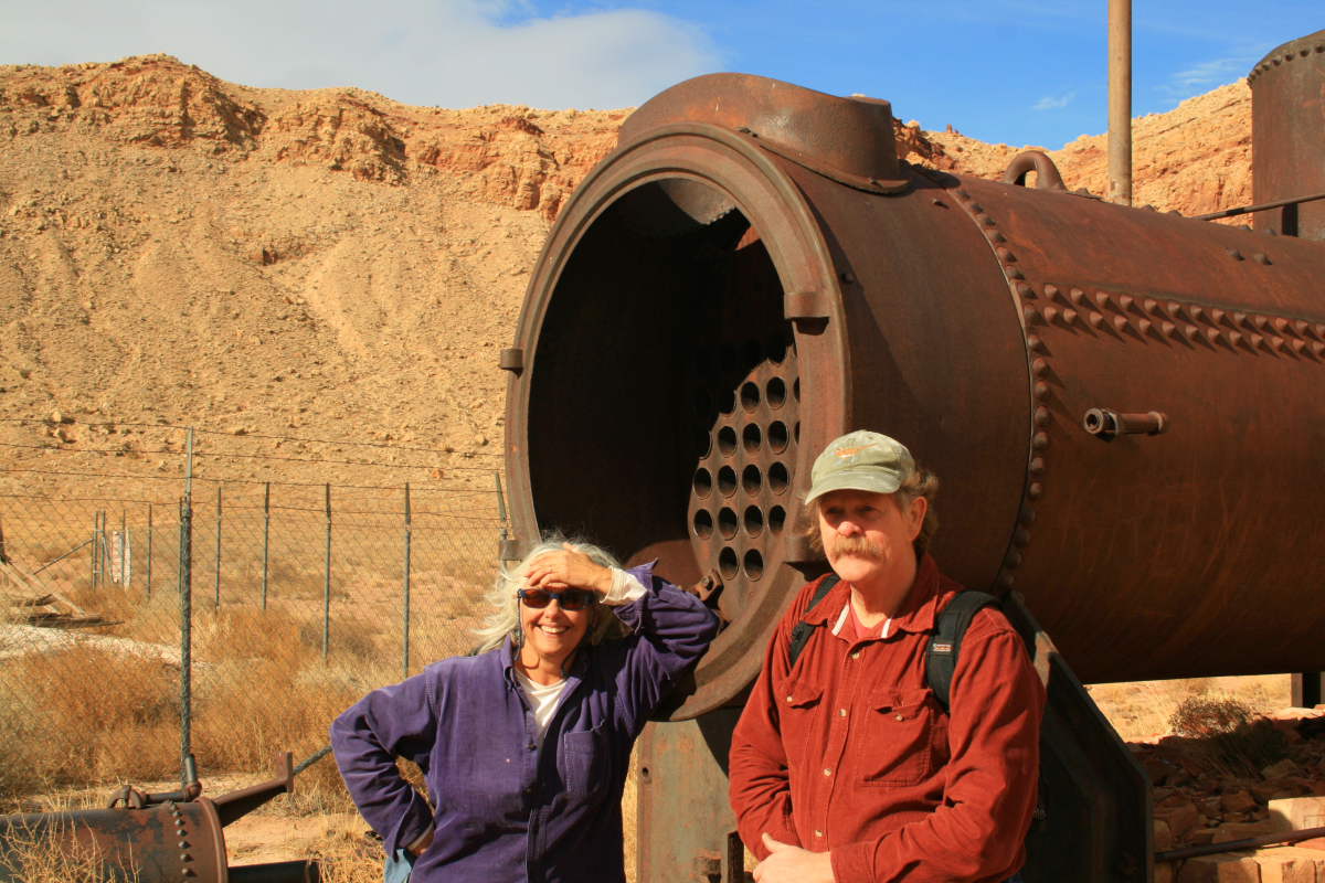
Author Rose Houk and geologist Michael Collier pose in front of the old boiler on the floor of the crater. We did not find any coal debris around the boiler and we were stumped as to how the boiler could have been fired.
As we made our way uphill along the steep trail, the clouds of an oncoming winter storm framed the crater walls. Thankfully, the storm held off until our return to the visitor center.
Not everything we saw related to the impact which is thought to have occurred about 50,000 years ago. Here in beds of the Moenkopi Formation are the burrowing remains of some Triassic critter (right of the lends cap) and in the block above this are impression of rip-up clasts within sandstone. To learn more about rip-up clasts, see my blog from a Henry Mountains field trip here.
Near the top of the trail are many old artifacts from days gone by. This looks to be some kind of contraption for use with mules that brought supplies to the crater floor.
Scott Harger inspects a huge block of ejected Coconino Sandstone on the rim of Meteor Crater. This specimen retains original Permian-age cross-bedding within it but was thrown out of the impact site. It is most likely overturned in this position.
This is a close-up view of the same block, which can be seen to be brecciated but still retaining original cross-bedding.
Looking into the ruins of the old visitor center on the rim of the crater.
Debris is strewn about the ruin site and documents a time long gone in northern Arizona.
Our group returning back to the museum area ans walking on top of a slab of Coconino Sandstone ejecta.
Here is a normal view of the Coconino Sandstone ejecta blanket on Meteor Crater's south rim. See the next photo for a clearer view of it.
Enhanced view of the Coconino Sandstone ejecta blanket. The rocks outside the colored area are Kaibab Limestone ejecta which is more golden in color.
A view northwest to the oncoming storm. The photograph was taken on the crest of the ejecta blanket and looks down about 120 feet onto the surrounding landscape. Thanks to Drew Barringer for allowing us geologists to experience this world-class landform from its central heart.


What an incredibly awesome experience! I've been to the crater rim and was blown away by its immensity. Thanks for taking me along.
ReplyDeleteAnother home run blog post, Wayne. This is armchair, vicarious traveling at its best. I've always wondered what it would be like to hike to the bottom of this famed crater. Thank you for documenting your journey is such great detail. We appreciate the "eye" you bring to such adventures.
ReplyDeleteAmazing post; too bad they don't let people hike into the crater. It would be a much more awesome experience than simply circling the rim.
ReplyDeleteYour photos, Wayne, are so helpful and well-composed. Thanks for the story which I found so interesting (no pun intended) on may levels: history, geology, the impact of this impact on earth, fauna and flora in the region, the relics of the past, how great it was to go to the crater bottom with Mr. Barringer, and that utilitarian things can be viewed with an artist's eye.
ReplyDeleteWayne, we were on our way to wrestling camp in Ponca City Oklahoma July of 1973. I grew up in Eagle Mountain California in the Kaiser Steel Iron Ore Mine. We stopped at meteor crater and my best friend Carl Cox and I, hiked to the bottom. We explored the buildings, saw the bore hole site. July as you know is HOT! Little did I know, but my friend Carl suffered severe migraines when he got too hot. Now I was 6 ft 2 then, am 6 ft 4 now. I wrestled heavy weight so I was a moose strong kid. Suddenly Carl was sick as a dog. So sick he couldn't continue. What do you do down there, when your folks are still up at the top in the car with the AC running? No phone to call for help! Well when you are the only moose around, you put your best friend on your back and you hump your way all the way back up to the top! It was a beautiful day for it. Growing up where we did a 20 mile day hike was nothing new to us. But that incline was TOUGH!!We made it out safely, got Carl cooled and I cooled down and were back on our way. I have loved geology since growing up on an Iron plate! Now I Live in Hibbing Minnesota back among the Iron!
ReplyDeleteThis was a GREAT Read and I really appreciate the photos for they brought back great memories!
Thank god for Wayne! you really made my week. Thank you Mark for that great story that made my day.
ReplyDelete