During the first week of November, I spent three days filming with a crew from "down under" for National Geographic and a special that will be called
"Supercontinent". This show will air sometime in the summer of 2010 and will portray what a supercontinent in the future may look like. I was asked to be a spokeperson on camera, since the Grand Canyon is Earth's greatest monument to erosion. I met the crew in Flagstaff and we drove up to the canyon for a sunset shoot on the first night. On day two, we flew in a helicopter from Grand Canyon to Castle Valley near Moab. We flew over the canyon, the Echo Cliffs, Page (where we refueled), Lake Powell, past the Henry Mountains, and finally over Canyonlands National Park. We then took both doors off of the chopper and I was interviewed while flying around Castle Rock. The director asked me questions as my feet dangled over 1,500 feet of airspace! It was hairy but fun. Thank goodness the weather was warm. On day three we filmed at the canyon on Lipan and Moran points, where I talked about the Kaibab and Coconino formations.
The crew was excellent and fun to be with. Repeatedly, they mentioned to me how spectacular the landscape in North America truly is. Crews like these film all over the world and see many different places, so their comments should not be dismissed easily. I think a lot of times the
politics of the United States becomes the foremost view that many foreigners tend to have about this place. Our landscape is then pushed into their background thinking. This is a long blog with 48 photographs. But the air was so clear during these days of filming and the views are spectacular. Those of you who have taken my geology classes will recognize many of these places. Enjoy!
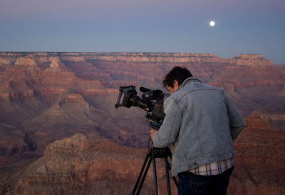
Our film shoot began with an evening at the Grand Canyon, catching the last light of day and a full moon rising to the east
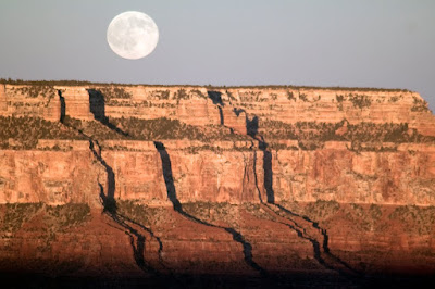
Here is a photo I took of the November 2 full moon rising over the Walhalla Plateau on Grand Canyon's North Rim

On the morning of November 3, we were up in freezing temperatures awaiting our day of filming in a helicopter to Castleton Tower near Moab, Utah

We flew south of the canyon but I was positioned in the chopper to get this view of the South Rim and Lipan Point on the far right
Our pilot swung around to the north and we crossed the Little Colorado River Canyon

The Echo Cliffs and Highway 89 can be seen in this shot

As usual, the coal-fired power plant at Page was belching its yellow cloud over some of the most scenic country in the world

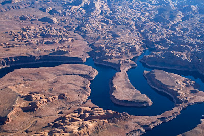
After a refueling stop in Page, we left for points northeast and crossed over Navajo Canyon and an arm of the Powell Reservoir

Tower Butte is composed of Entrada Sandstone and sits very near the Utah/Arizona state line

Like the Colorado River, our path was through the gap between Navajo Mountain and Navajo Point shown here. Note the Henry Mountains in the far distance, the Straight Cliffs Formation on top of the Kaiparowits Plateau, and the Tropic Shale horizon below the top of the point.

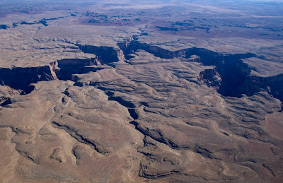
Looking at large meander bends in the old channel of the Colorado River towards Oak Bay

This is an aerial view to the northwest of the Straight Cliffs, along the edge of Fifty-Mile Mountain. So many times I have seen this graceful escarpment from the ground and it was just as spectacular from the helicopter!

A view of the southern end of the Waterpocket Fold near the old channel of the Colorado River. Slopes on the far laft are cut into the Chinle Formation and the cliff-forming Wingate Sandstone is visible (center). To the right of this, a broad valley has formed within the Kayenta Formation and rounded bluffs of light-colored Navajo Sandstone are seen on the far right.

In the distance, the large embayments at Bullfrog Creek (left) and Hall's Creek (right) can be seen. In fact, you can see some boats moored at the Hall's Creek Marina if you look closely.

This past April I took a group of geology students to the Henry Mountains for a field trip. Here is an aerial view of the upturned Navajo Sandstone beds that we explored on the southern flank of Mt. Hiller's. To see the blog with photo's of these upturned beds from the ground,
click here.

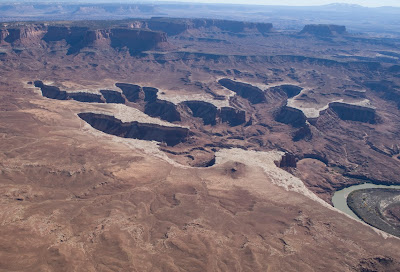
A large meander of the Colorado River is still evident even after being filled with water from the Powell Reservoir. The Little Rockies (left) and Mt. Hiller's (right) are also visible.

This is the old mouth of North Wash where it entered the Colorado River (Utah State Highway 95 travels along an upper stretch of North Wash to Hanksville). Note the marvelous reflection of the rocks (Organ Rock Formation) in the water - our day was calm as could be for flying.

Here is a view of Highway 95 as it snakes towards the bridge over the Colorado River. The white platform that the road traverses is on the Cedar Mesa Sandstone. The Organ Rock and Moenkopi formations form the red aprons on the buttes, which are capped by thin exposures of the White Rim Sandstone. The obvious band of orange in the middle of the buttes is a unit known as the Hoskininni Member of the Moenkopi.

A view of buttes in the drainage of the Dirty Devil River, with the Henry Mountains in the background

These are the famous Buttes of the Cross in the far western part of Canyonlands National Park. The Chinle Formation makes up the aprons of the buttes and they are capped by Wingate Sandstone and a thin remnant of the Kayenta Formation.

A Triassic paradise! Note the colorful banding in the Chinle Formation at the base of these buttes.

This is an abandoned meander in Anderson Bottom along the Green River in Canyonlands National Park. You can clearly see that the river once flowed around this loop before it cut-off its channel through a narrow gooseneck. The cap rock is composed of the White Rim Sandstone.
A view of the deeply eroded White Rim Sandstone along a tributary of the Green River. Features such as these head-scarps strongly suggest that
groundwater sapping is what most likely has shaped the tributary canyons. This process involves groundwater that seeps out at the contact between the porous sandstone above and an impervious layer (the Organ Rock Fm.) below. Undercutting of the sandstone causes the canyon to grow in the upstream direction. Evidence for groundwater sapping can be seen in many southwestern canyons.

An aerial view of Upheaval Dome, now documented to be a meteorite impact structure (and not a salt dome) that formed perhaps 60 million years ago. For more information
see this link.

As we approached the Canyonlands Airport near Moab, we crossed over beautiful exposures of the Entrada Sandstone. The orange, banded beds in the canyons belong to the Slickrock Member, and the highly jointed cap rock belongs to the Moab Tongue Member.
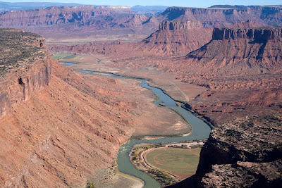
After a refueling stop at the airport, we removed the two back doors to the helicopter and I got to fly over the countryside with my feet dangling 1,500 feet above ground. It was exhilarating to say the least! Here is a great view of the Colorado River upstream from Moab, with the Red Cliffs Lodge located in the big loop along the rivers' edge.

Here is a view of the river farther upstream from the previous photo, and shows the entire "Daily run" on the river. I will post a blog from a river trip taken on this stretch in just a few more days.

Our target exposure for the entire day was Castle Rock, also known as Castleton Tower. Our director interviewed me as the cameraman took shots of me looking at the tower. We flew around the butte for about 35 minutes and saw many climbers on it.

Another view of Castle Rock, an excellent example of erosion, which was the topic for the shoot. The tower is composed of Wingate Sandstone and sits on softer beds of the Chinle Formation. Note that well-cemented layers form cliffs and softer layers form slopes.

Dark colored mudstone in the Morrison Formation is being stripped off of the harder beds of the Moab Tongue Member of the Entrada Sandstone

This shot was taken on our way home about 3 PM. It shows fins of highly jointed Navajo Sandstone in the vicinity of Back of Beyond Wilderness Study Area. In the far distance is the La Sal Mountain laccolith, intruded as magma into the strata some 28 million years ago.

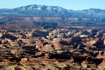
Flying over the heart of the Needles District of Canyonlands National Park, I saw a great view of one of the Six-Shooter Peaks to the east. The Orange Cliffs are in the middle distance and the San Juan Mountains covered in snow can be seen in the far distance.
A view of the Abajo Mountains laccolith rising above the Needles District of Canyonlands, with exposures of the Cedar Mesa Sandstone seen in the foreground.

Looking southeast up the White Canyon drainage (cut into Cedar Mesa Sandstone). Highway 95 is visible on the south rim of the canyon.
These are meanders of the San Juan River just upstream from its confluence with the old Colorado River

A view of the north side of Navajo Mountain, the only Colorado Plateau laccolith in which the core is not yet exposed. The "shredded" canyon country at the foot of the mountain is a joy to hike in.

A great view of the western edge of Cummings Mesa. Groundwater sapping again appears to have shaped this part of the Colorado Plateau.

After another refueling stop in Page, we flew over the Lees Ferry area and the head of the Grand Canyon. The canyon behind the ferry area (along the river) is the Paria River Canyon, with the north end of the Echo Cliffs in the late afternoon sun.

Flying over Marble Canyon, we got a great view of the Badger Rapid area. Note the shallow canyons on the Marble Platform. Hmm?

Another view of shallow canyons on the Marble Platform - all curiously head to the north and down the slope of the Kaibab surface. The light was fantastic.

The Echo Cliffs, composed of Triassic and Jurassic strata

Now we are approaching the Grand Canyon once again and looking southeast towards Zoroaster Temple. A prescribed burn can be seen on the north flank of the San Francisco Peaks in the far background.

Once on the ground, after eight hours in a helicopter, I took a picture of our film crew. What a day!
This is a photo that the crew took for promotional purposes of the show.
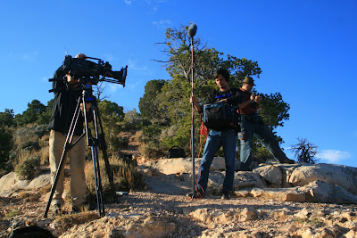
Filming at the Grand Canyon
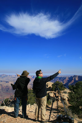
Having fun (at the expense of a cloud) while filming at Lipan Point

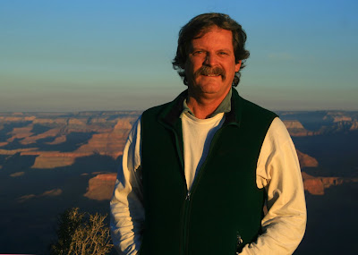
This is one of the interview segments taken at Lipan Point. We were on the rim of the canyon all day.

Another one of the promotional shots used by the film crew. Experiences such as these provide wonderful opportunities to share geology with a much wider audience. Our society is woefully ignorant of the importance of earth history in our lives. Educational television shows are one way to connect people with the world they live in and that is the reason I partake in endeavors such as these.
 This is what the weather looked like on Saturday morning near the Red Cliffs Lodge. A big storm was definitely moving in. Fortunately, it did not precipitate during the daytime while everyone was inside attending lectures. But we could tell that "something big" was moving in.
 And this is what we woke up to on Sunday morning! It has snowed all night while we slept at the Lodge. Snow this time of the year is somewhat rare at this elevation.
 A graceful cottonwood tree frames the red rock cliffs at Hittle Bottom
 Here's Michael rigging his boat in the snow. I have rarely (if ever) run a river in such snowy conditions.
 Once we put-in on the water it was fantastic scenery
 This is a view towards the Fisher Towers, which always feature prominently in my lectures not only because of their scenic erosional forms, but also because of their stratigraphic significance as well. The cliff top is capped by Wingate Sandstone, with an apron of the Chinle Formation below it. The prominent break in the snow-covered slopes (center part of the photo) is composed of the Moenkopi Formation. This unit also caps the towers, which are composed mostly of the Cutler Group. Close-ups of this unit follow below.
 Our flotilla of four boats passes a scenic bluff along the Colorado River. It is composed of the Cutler Group.
 Loie and Buzz Belknap admire an excellent view of the Cutler rocks. Look for the coarse cobbles of granite in this outcrop, that document deposition in rivers and streams that were flowing out of the Ancestral Rocky Mountains about 290 Ma. These same strata pinch out just five miles to the east and against bedrock that is composed of the same granite. This is the evidence that the Ancestral Rockies once stood where the modern Rockies are today.
 I climbed a small hill behind our lunch stop and took a picture of the snow-framed river. Note the red colored run-off on the far bank of the river - as the snow was melting, Onion Creek ran deep red with silt and sand.
 Our group enjoying lunch in the warm sun
 The La Sal Mountains (right) are a landscape icon in the Moab country. Red rock strata dominate the area but an occasional laccolith pokes through these strata. The stunning contrast between the snow-capped peaks and the snow-mantled strata was striking.
 Paddlers floating by one of the local ranches with the Fisher Towers in the background.
 A closer view of the scene above
 This is the north side of a rock known as the Priest and Nuns, and Castleton Tower (Castle Rock). See the previous blog entry for photos of this same rock taken from the seat of a helicopter two weeks prior!
 A view north to the Cache Valley fault. This may be associated with a salt dome in the area.
 Close-up view of the thinly-bedded Moenkopi Formation just downstream from the Cache Valley fault. What a wonderful day this was and a hearty thanks to our hosts at Plateau Restoration! Check out their great work at www.plateaurestoration.org.
 DEER ON ROADWAY
 DEAD OR ALIVE


