Saturday, August 19, 2017

Chasing the 2017 North American Eclipse

I am just back from working and lecturing on an expedition ship in Alaska. The very first time I came back from "The Last Frontier" to the lower 48 from such a gig was in July, 1991. And as soon as I returned home back then, I took a very long road trip to see a total solar eclipse in Baja California. I guess some things never change - even after 26 years, 1 month and 1 week.

Yep I am on the trail to the way-to-hyped but not-to-be-missed Great North American Eclipse. Most references leave out the "North" part but when a big shadow across the planet travels a quarter million miles spanning the entire continent, I feel it deserves that larger description.

I've been planning this trip for at least four years now. So when the hype about gas stations running out of fuel and 30-mile traffic back-ups in Prinville Oregon began to circulate, I did wonder if I should to begin stress about it. Then I remembered how in 1991 things just kind of moved into place the way they were supposed to. On that trip, I couldn't decide if I was going to drive to watch the eclipse in Mazatlan on the mainland, or do a much wilder and remote trip down the spine of the Baja Peninsula. I fretted for the whole 142 miles from Flagstaff to Phoenix on which way to go. I was trying to guess about the cloud cover. At one point I thought the mainland would be better, 10 minutes later I was leaning toward Baja. It went back and forth like this for 141 miles. As I approached the stack where I-17 meets I-10, I knew I only had a minute to decide. At the last second I thought, "Well, if its cloudy in Baja, at least I'll be in Baja! I took a turn to the west and it turned out great.

There was a bit of back and forth about this one too. Stories about thousands and thousands of people cramming along the center line did not go unnoticed. But I had planned a detailed back road route back in early June of this year and as it turned out, I stuck with that. Here is the story of my approach.


I pulled away from Flagstaff on August 18 at 2 PM - only one hour later than planned. I took my time loading the car and did not stress a bit. I soon realized that I would be traveling on five segments of road during this trip. The first segment - south to north from Flagstaff to near Tuba City - would be the shortest at about 70 miles. The second segment was the first west to east one to near Mexican Water, AZ. The third segment took me north again to Moab, Utah where I overnighted. Then I turned east again onto I-70 through Grand Junction and on to Wolcott, Colorado. The fifth and final segment took me north into the promised land - Wyoming and the town of Laramie for night 2.

The skies in Arizona were clear as could be - the recent summer rains had scrubbed them clean. There were some puffy clouds and believe it or not, I only stopped once (for five minutes) between Flag and Moab. As I exited Bluff, Utah, I called my friend Chuck since he had mentioned that he might go up to see the eclipse. I wanted to see if he made it out of town or not. When he picked up the phone he was just entering Moab. We chatted a bit and then he said, "Oh oh, that doesn't sound good." Something in his rear transmission case went way bad. Within minutes he was saying, "My trip is over." I told him I'd be there in an hour and a half and could help if need be.

As I pulled into Moab I called again. Yep, his car was down and out. So I pulled into a shake shop and got he and wife a chocolate shake. When I caught up with them at the junction of US Highway 191 and the River Road, the tow truck was there and I handed them both those shakes. They were so pleased! Then Chuck said, "Hey, I called my friend Cynthia to ask about a mechanic in town and she said, 'I'm up here in Idaho for the eclipse so just crash at my place - the key is under the yellow pot.' Chuck invited me over too. So instead of camping my first night I set up the cot in her living room and slept indoor with plumbing and air conditioning. Yep, its all going to work out just fine.

We had breakfast at the Moab Diner, I said goodbye and was underway at 8:30 AM. My camera was on the passenger seat next to me but I had so far waited to use it. Once the camera comes out, it becomes a different sort of trip. It was scenic enough passing east of Grand Junction, and I just had to stop in Palisade Colorado for some peaches! I got six huge ones for $6 - they are indescribably juicy! I went east through the young lake beds (only 50 million years old!) sliced open by the Grand River (Sorry - I like the original name for this section of the present-day Colorado River). Then at Rifle Colorado, the young lake beds were upturned and much older rocks appeared by Glenwood Springs. It was great to see this large uplift. Just east of Eagle, the beds dipped down again and we were back in younger rocks. Then at Wolcott, the last segment began.

I tuned north and drove from State Bridge to near Kremling. This was the only dirt stretch in the whole approach. I took my first picture when the road climbed up above Gore Canyon.

Gore Canyon. Note the tracks of the Union Pacific Railroad above the Grand River.

These Precambrian gneisses and schist and essentially the same as the Vishnu Schist in Grand Canyon and part of the Yavapai terrane.

So far, I had not detected any "Eclipse traffic." There may have been some but I-70 was not really that busy. When I turned onto US Highway 40 from Kremling toward Steamboat Springs, I was looking for obvious traffic but couldn't detect any. As soon as I began to suspect eclipse traffic, the roads would become quiet again. I suspect what I saw on US Highway 40 was just normal Denver-to Steamboat Springs traffic on a summer Saturday.

 US Highway 40 west of Kremling Colorado.

Wheeler Peak on the north side of US Highway 40.

Summer flowers on a stretch of Highway 40.


All along this stretch are signs for the F.M. Light & Sons boot and hat shop. They are reminiscent of the Burma Shave signs elsewhere.

Here's my ride! In 1991 I had my 1984 Toyota 4X4 pick-up. I still have her and wanted so much to take her. But she might not have given me the level of confidence this baby can.

At Muddy Pass (elev. 8772) I turned onto Colorado State Highway 125. The pass was not very evident as it is one of the lowest passes across the Continental Divide. I moved from the drainage of the Grand River into the drainage of the North Platte. Woo hoo!

In this stretch of land near Walden Colorado the rocks are Cretaceous shales and there is a bit of oil and gas activity here. Those are the peaks in Rocky Mountain National Park in the far distance. Again, I kept looking for eclipse traffic and may have seen three or four cars that fit that description (young folks - often single men - in pick-up trucks with river running or climbing stickers all over the back). Then just past Chowdry, Highway 125 went west and 127 went east (my route). Every suspected eclipse traveler I saw went the other way!

Just past Chowdry on Highway 127 is this old-looking gneiss. I suspect this may be the trace of the Cheyenne fault where the younger Yavapai terrane was sutured onto the much older North American craton. If true, these rocks are 3 billion years old!

The color change in the pavement can only mean one thing.

I made it! Wyoming, North America. Fantastic! This was by far the quietest stretch of highway I encountered on the whole trip. Between Chowdry and Woods Landing (just before the outskirts of Laramie), I saw one other vehicle going towards the center line! This was certainly a great route to take. I had heard that I-25 between Denver and Colorado Springs was crazy busy.

Into Laramie - a long time coming. I have always wanted to come here for a number of reasons. Some of my favorite geology professors at NAU got their PhD's here, it is known as the highest elevation 4-year university in the United States (with NAU in Flagstaff second), and (drum roll please) it is the location of the Laramie Basin, a 70 to 40 million year old depression that gives the Laramide orogeny its name. Awesome!

It is a quaint old town with many old homes and buildings. Looks like there is a big switching yard here for the Union Pacific transcontinental railroad.

Corner of Garfield and 2nd St. in downtown Laramie.

My first bonafide eclipse seekers at a gas station in Laramie. Three 30-somethings looking on their cell phone for, what? Weather updates, traffic alerts? Regarding gas, I had filled up in Grand Junction and then told myself I would top off when it got to half full. That was about in Kremling. Gas was $2.50 and I almost pulled in...but...I kept going...in Walden it was $2.59...I almost topped off again but held back...Wyoming is full of oil and gas...and even though it may be crowded with eclipse-goers...I'll just stretch it a little more.... I filled up here for only $2.12 a gallon. You win some and you lose some.

I'm overnighting here to get a fresh start on the day before the eclipse. Thanks for reading.

Sunday, August 13, 2017

Katmai National Park and the Alaska Peninsula

This morning The World is docked in Dutch Harbor Alaska on Unalaska Island in the Aleutian chain. Dutch Harbor was attacked in World War II and eleven Americans lost their lives in the bombing. We will visit the World War II Museum here later today.

We have enjoyed generally good weather on this trip and it is my pleasure to share more photos with you. This posting has less geology and more nature - the Brown bears we saw at Geographic Harbor in Katmai National Park were phenomenal.

This is part of the ruins of Ft. Abercrombie on Kodiak Island. When Kiska Island was taken by the Imperial Japanese Army, the American military fortified many of the other Aleutian Islands in the Pacific. Ft. Abercrombie was one of these fortifications. It is now an Alaska State Park.

Kodiak Island is the 2nd largest island in the United States (Hawai'i is the largest) and contains the extreme northern end of the North American temperate rain forest. The southern-most edge of this rainforest is found way down along California's Big Sur coast.

They do green like the Colorado Plateau does red! Mosses cover the branches of a Sitka spruce tree in the State Park.

Ferns in the rain forest on Kodiak Island.

A road cut in the town of Kodiak exposed deep water marine sediments that are part of the Chugach terrane. See my previous posting for a simple description of terrane geology. A more detailed and scientific description of the Church terrane can be found here. Generally, these rocks were deposited in a deep marine trench like the nearby modern Aleutian trench. These sediments are Late Cretaceous to Eocene in age, about 75 to 55 million years old.

The World at anchor at the mouth of Geographic Harbor in Katmai National Park, Alaska Peninsula.

 Entrance to Geographic Harbor and a slow Zodiac cruise to the inside of the harbor.

Foliated intrusive rocks are part of the volcanic complex here.

Note the dark-colored bedrock in the peak and the light-colored talus slopes below it. The lighter material is volcanic ash from the June 6, 1912 eruption of the Novarupta volcano, located about 20 miles north of this spot. The 1912 eruption of Novarupta is considered the largest volcanic eruption on Earth during the entire 20th Century and is surpassed in all of recorded history only by the 1815 eruption of the Tambora volcano in Indonesia. It covered a nearby valley in over 300 feet of pyroclastic material. Even though no one was nearby to record the events of this eruption, modern-day volcanologists with more tools have revealed the sequence of events that occurred here during the 60 hours of eruption. It is now one of the best studied volcanic eruptions known. You can read more about the eruption and its aftermath here (and in the contained links).

In Geographic Harbor, it was difficult to focus on geology as no fewer than nine bears were ambling along the shoreline in this relatively small area.

Close-up of the mother bear seen above. The species is known as the American brown bear (Ursus arctos horribilus), the silver tip bear, or the grizzly bear. They did not seem so fierce when viewed from the safety of a boat.

Viewing bears safely from a Zodiac. They hardly even noticed us quietly sitting out in the water. about 75 meters away It would have been a much different feeling had we been walking ashore or camping here.

Katmai National park boasts nearly 2,200 bears in its 4 million acres.

Another mother with her two cubs digging for amphipods in the tidal mud.

This cub is about 7 months old. Anyone wanting to see Brown bears in their native habitat got what they wanted on this trip. Next stop - the Semidi Islands.

Zodiacs ready for a landing at the Semidi Islands.

We climbed up to a pass on the island that allowed us to view its rocky shore. Geologically, these islands are a southwest extension of the Chugach terrane and of Kodiak Island.

Close-up of shoreline.

This coast suffers the brunt of harsh winter storms from the open Pacific Ocean. Huge driftwood logs were thrown-up on the shore of cobble beach. In the distance some 10,000 miles is the shoreline of Antarctica, the next bit of land in that direction.

This is Rose root (Rhodiola rosea). My colleague Conrad Field made the identification for me and I was surprised how important this plant is to Artic peoples for medicinal purposes. Check out the link above.

Horned puffins (Fratercula corniculata) can be found on these islands. They nest here but spend up to seven months on the open water in winter.

Next stop is the Shumagan Islands and the island of Unga (ninth largest island in the US). We stopped in Delarof Harbor at an abandoned fishing village that provided a great palette for photography.

This is the grave of a young girl who likely died in the influenza epidemic of 1918.

Church steeple in Unga. The village was last inhabited in the 1970s and served as the base for a cod fishery before abandonment.

Two Great horned owls (Bubo virginianus) in a Sitka spruce tree in the village of Unga.

A yellow paintbrush (Castilleja unaleschcensis) is a common wildflower in this part of Alaska.

The World at anchor near the east shore of Unga Island. There is a gold prospect on this island that is gearing ups for operation. So far, 150,000 ounces of gold have been taken from here (in historic time) and the new venture may yield much more. Read about it here.

A northern sea otter (Enhydra lutris kenyoni) rests in the quiet waters of the bay.

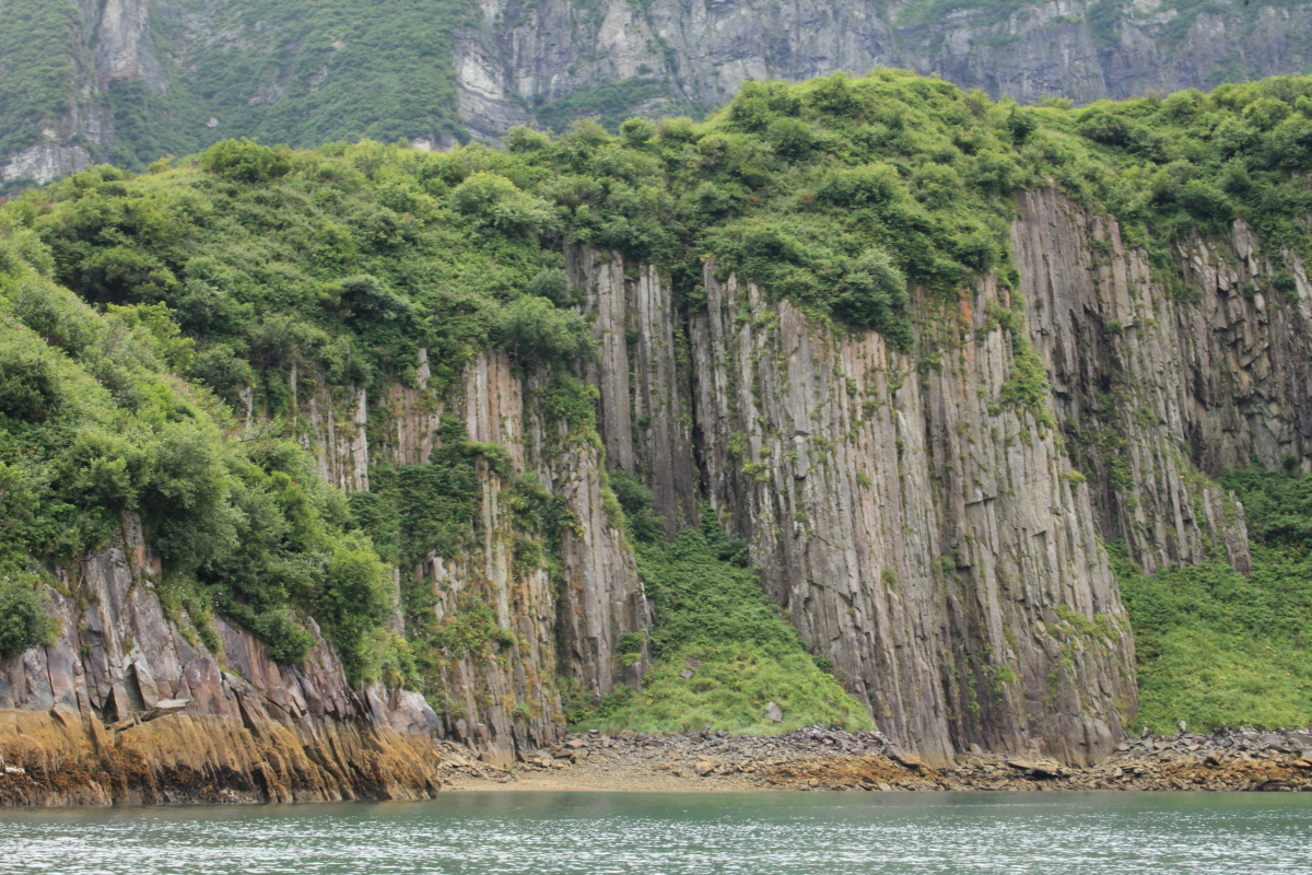
Near the outside of Delarof Harbor are these fantastic shapes.

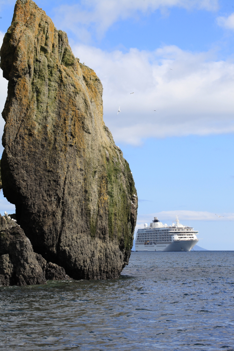
Rock and The World.


A final stop was made on Unimak Island, the easternmost of the Aleutian chain. The Isanotski volcano stands at 8,104 feet above sea level as viewed from Otter Cove looking to the northwest.

Zodiac and The World in morning light in Otter Cove on August 12, 2017.

Bear trackway on the sand at Otter Cove.

This has been a wonderful voyage on The World. Thanks to all of the residents here who make my visit with them possible.