On our recent trip to Hawai'i we also spent some time on the island of O'ahu. Long maligned as a piece of paradise that suffers from ubiquitous urban blight, this island is a marvelous place to mingle with Hawaiian culture and gaze at spectacular Hawaiian geology. My sister Laura lives on O'ahu and she took took time off from her job at the University of Hawai'i and treated us to a two day adventure around the perimeter of the island.
We started our excursion on O'ahu's far eastern shore. Here the northeast trade winds batter the coast and expose the many tephra deposits found on this side of the island,
This is Koko Crater, a cinder cone that is approximately 10,000 years old, making it one of the youngest eruptive features on O'ahu. This crater is 1,207 feet in height and the slopes of it drop steeply into the Molokai Channel. Note how runoff has created numerous gullies and rills in the volcano's eastern slope.
Nearby is the fabulous Hanauma Bay, where a shoreline crater has been breached by the incoming waves. This has formed a protected cove that is quite popular with snorkelers. The last time I was here was in 1983 and the increase in visitation is staggering.
Wikipedia offered this aerial view of Koko Crater and Hanauma Bay and gives you a birds eye view of the scenic splendor of Oahu.
The afternoon waves batter the eastern coast of O'ahu
Around the corner to the north is a spectacular coastline with the famous North Shore pali (or sea cliff). Note the out-wash debris that protrudes out into the sea here. The northeast trade winds bring immense storm systems that slam into the islands, causing phenomenal runoff events that progressively (or catastrophically) create these features - a real estate brokers dream when it first happens but a home owners worst nightmare when it happens again.
Another view of the same pali further west along the North Shore drive. This pali formed when a huge chunk of O'ahu slid away to the north.
This map, used courtesy of the Monterey Bay Aquarium Research Institute, shows the two islands of O'ahu and Moloka'i (shaded in dark green). The other colors represent the depth of the seafloor, progressing from nearshore (white) to deep (dark blue). The light green and light blue areas depicted north of the islands are interpreted as large areas of debris that originated from catastrophic landslides from these two islands. The pali's originated when these landslides occurred. Note how the largest chuck of landslide material, located up to 70 miles away from O'ahu, lies parallel to the North Shore. Imagine these slides when they occurred and the tsunami's that likely resulted from them.
Rabbit Island is another tuff cone along the North Shore that has been beaten by the sea on its eastern (right) side.
The Chinaman's Hat on O'ahu's North Shore. Read more about it here. It is composed of layers of lava that are erosional remnants from the main island flows (to the right off of the photo).
Another spectacular view of the pali as we wind our way west on the North Shore drive. Note how the runoff from all the rain here has created the pattern on the cliff wall.
Although Honolulu is what most people think of regarding O'ahu, we found this North Shore to be every bit as Hawaiian as any other place we've been in Hawai'i. It is rural, slow-paced, and very scenic.
The Waimea Valley looked very interesting to us, with a botanical garden and numerous trails. The entrance view from the highway was very enticing and we may return one day to check it out.
Next we saw a small crowd that had gathered and upon inspection found some green sea turtles hauled out on the beach.
As we watched, even more turtles came ashore. Volunteers stand nearby and move ropes that keep people from getting too close to the turtles.
The bridge entering Haleiwa on the North Shore.
Haleiwa is a delightful town where we strolled for about an hour.
In the graveyard of a Haleiwa church was this headstone - that of a missionary. It is always fun to walk around graveyards but this one made me wonder why some brow-beaten missionary thought Hawaiians needed to be "saved". How strange humans are sometimes.
On a lighter note were the many hippie shops located along the roadway. Seems other, later arrivals came here to be saved from the drudgery of mainland life.
This may look like a tourist shot of Helen and me on Waikiki Beach but it's actually a geology shot of Diamond Head in the background. (Note: We did enjoy Waikiki and always do when we are here. It is a great beach with a lot of history). Diamond Head is another tuff cone that was erupted about 150,000 years ago.
This is my sister Laura in front of the entrance to Diamond Head, where we hiked to the top.
The trail begins as a concrete sidewalk through the small forest on the crater floor...
but soon turns to an asphalt lane that swithbacks up the inside of the cone.
The view from the top is spectacular. You can see the floor of the crater where the hike begins. Note the tunnel one drives through to access the trailhead. The outer view is to the east and takes in the features shown at the start of this O'ahu roundabout - Koko Crater to the left and Koko Head to the right. The neighborhood of Port Lock where my sister lives sits below these two.
Here is a view of the lighthouse that faces the south on the Pacific Ocean.
And a final view of Honolulu to the west of Diamond Head. Note the gap in the high rise buildings along Waikiki Beach. You might see the pink Royal Hawaiian Hotel there where the picture of us on the beac h was taken. On the skyline is the Waianae volcano, the oldest of the two shield volcano's that made the island of O'ahu. It was active between about 3 and 4 million years ago.
Helen and I really enjoyed our time on O'ahu and there is much more to this island than shopping and surf.
Adventure and foreign travel, philosophical and scientific musings, geology and landscapes, photography and earthly explorations.
Sunday, June 12, 2011
Thursday, June 02, 2011
Hawaiian Geology at Haleakala Crater
I'm on vacation on the island of Maui in Hawai'i where Helen and I completed an eleven and a half mile hike on May 30 through Haleakala Crater. The summit of this impressive volcano rises 10,023 feet above sea level and after adding the 16,000 feet of height that is below sea level, this volcano is over 26,000 feet high! Take a look at some of the photos from the summit and inside the crater.
The view towards West Maui volcano. We set our alarm for 5 AM so that we could begin the hike well before the clouds build up. This is not how most visitors to Hawaii spend their day (alarm clocks, fleece jackets, hiking shoes and socks, etc.) but I can highly recommend this activity while visiting here. This view to the west is towards the West Maui volcano, already cloaked in clouds at 7 AM. The lowlands in the foreground is the valley between the two volcano's and is where most people reside on this island.
Our first view of the crater was from Kalahaku Overlook at 9324 feet along the summit road. The parking area reveals nothing but a short walk to the edge brings visitors to a most spectacular view. Haleakala is not an eruptive crater but rather is a depression that has formed from repeated slumping on the summit. In this wet tropical climate, moisture seeps into the volcanic rock, causing large portions of the mountain to slide down to the sea. This photo was taken on the west rim of the crater and looks across to the south rim, about two and half miles away. The obvious cinder cone on the floor of the crater is called Ka Lu'u o ka O'o.
Swinging the view farther to the left on the crater floor brings one to a cone called Kama oli'i. You can see that a lava flow issued from its right hand side, which flowed downhill to the east and around its near side. A typical sequence in many cinder cone eruptions is that gas charged lava erupts first in fountains of lava droplets. These cool and form the cinder cone around the vent. Once the gas is gone out of the lava, it cannot be thrown up into a fountain and pools within the cone. It then breaches the side of the cone as a lava flow.
Swinging our view even further left brings this scene. The lava flow that erupted from Kama oli'i has almost completely engulfed a previously formed cone (seen embedded in the middle of the lava flow). Another cone is present beyond the flow and it is called Pu'u o Maui. Maui is the demi-god namesake of the island.
A last look from Kalahaku Overlook with the highest mountain on Earth visible in the far distance, Mauna Loa on the Big Island of Hawai'i. It is over 13,000 feet above sea level and is higher than Mt. Everest with it's submarine portion included in its height. The air quality was outstanding this day to achieve this view.
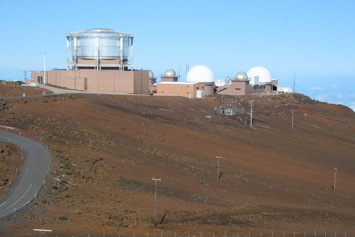
On the summit of Haleakela are a number of astronomical observatories and NASA space tracking facilities. They are off-limits to the public but easily visible from the summit which has a small hut for viewing out of the wind or snow (when they have snow).
Helen beginning the hike at about 8:30 in the morning. In the entire 11.5 miles, we saw perhaps six people on the trail.
This is a view to the west as the trail switchbacks down the side of the crater.
A view to the north back towards the direction of Kalahaku Overlook. The spectacular wall in the distance is the cliff we would ascend to exit the crater about five and half hours later.
The silversword (Argyroxiphium sp.) is an endemic plant on Haleakala that takes 5 to 50 years to bloom, signaling the end of its life cycle.
Silversword close-up. I took a side hike on the Silversword Loop where hundreds of these were growing in their native habitat of rocky, well-drained soil.
Looking back to the west towards the summit of Haleakala (located on the flat-looking ridge top left). The chain of craters was formed along a rift present beneath the volcano.
The floor of the crater has some green growth on it, especially where the windward side rains spill into it. Here you can see some clouds moving into the crater from the windward side.
Here is a a view of Pu'u o Maui from the floor of Haleakala Crater. Compare this view with the one from the overlook above.
I accidentally hit a button on my camera and then about 60 of my pictures were taken in black and white. Here Helen approaches our lunch spot near a spatter cone or hornito. The lava globules in the walls of this were fantastically preserved.
Just before our ascent we looked back up at the wall we had to climb. Good thing I took the photo at this moment as the clouds began to roll in off of the Pacific.
In Hawai'i, volcanic features are so easily seen and observed. Here along the trail in the floor of Haleakala is a lava tube partially obscured by a patch of grass and flowers (upper left). A pahoehoe flow issues from this with lava levees on either side of it. This is textbook volcanology!
After finishing the hike we looked out into the Pacific Ocean and saw the area near Big beach with ts shoreline cinder cone. The little islet in the sea is called Mokulini and is a crater that is breached on one side with the ocean inside it. Te island of Kaho' o lowe is in the distance.
The view towards West Maui volcano. We set our alarm for 5 AM so that we could begin the hike well before the clouds build up. This is not how most visitors to Hawaii spend their day (alarm clocks, fleece jackets, hiking shoes and socks, etc.) but I can highly recommend this activity while visiting here. This view to the west is towards the West Maui volcano, already cloaked in clouds at 7 AM. The lowlands in the foreground is the valley between the two volcano's and is where most people reside on this island.
Our first view of the crater was from Kalahaku Overlook at 9324 feet along the summit road. The parking area reveals nothing but a short walk to the edge brings visitors to a most spectacular view. Haleakala is not an eruptive crater but rather is a depression that has formed from repeated slumping on the summit. In this wet tropical climate, moisture seeps into the volcanic rock, causing large portions of the mountain to slide down to the sea. This photo was taken on the west rim of the crater and looks across to the south rim, about two and half miles away. The obvious cinder cone on the floor of the crater is called Ka Lu'u o ka O'o.
Swinging the view farther to the left on the crater floor brings one to a cone called Kama oli'i. You can see that a lava flow issued from its right hand side, which flowed downhill to the east and around its near side. A typical sequence in many cinder cone eruptions is that gas charged lava erupts first in fountains of lava droplets. These cool and form the cinder cone around the vent. Once the gas is gone out of the lava, it cannot be thrown up into a fountain and pools within the cone. It then breaches the side of the cone as a lava flow.
Swinging our view even further left brings this scene. The lava flow that erupted from Kama oli'i has almost completely engulfed a previously formed cone (seen embedded in the middle of the lava flow). Another cone is present beyond the flow and it is called Pu'u o Maui. Maui is the demi-god namesake of the island.
A last look from Kalahaku Overlook with the highest mountain on Earth visible in the far distance, Mauna Loa on the Big Island of Hawai'i. It is over 13,000 feet above sea level and is higher than Mt. Everest with it's submarine portion included in its height. The air quality was outstanding this day to achieve this view.
On the summit of Haleakela are a number of astronomical observatories and NASA space tracking facilities. They are off-limits to the public but easily visible from the summit which has a small hut for viewing out of the wind or snow (when they have snow).
Helen beginning the hike at about 8:30 in the morning. In the entire 11.5 miles, we saw perhaps six people on the trail.
This is a view to the west as the trail switchbacks down the side of the crater.
A view to the north back towards the direction of Kalahaku Overlook. The spectacular wall in the distance is the cliff we would ascend to exit the crater about five and half hours later.
The silversword (Argyroxiphium sp.) is an endemic plant on Haleakala that takes 5 to 50 years to bloom, signaling the end of its life cycle.
Silversword close-up. I took a side hike on the Silversword Loop where hundreds of these were growing in their native habitat of rocky, well-drained soil.
Looking back to the west towards the summit of Haleakala (located on the flat-looking ridge top left). The chain of craters was formed along a rift present beneath the volcano.
The floor of the crater has some green growth on it, especially where the windward side rains spill into it. Here you can see some clouds moving into the crater from the windward side.
Here is a a view of Pu'u o Maui from the floor of Haleakala Crater. Compare this view with the one from the overlook above.
I accidentally hit a button on my camera and then about 60 of my pictures were taken in black and white. Here Helen approaches our lunch spot near a spatter cone or hornito. The lava globules in the walls of this were fantastically preserved.
Just before our ascent we looked back up at the wall we had to climb. Good thing I took the photo at this moment as the clouds began to roll in off of the Pacific.
In Hawai'i, volcanic features are so easily seen and observed. Here along the trail in the floor of Haleakala is a lava tube partially obscured by a patch of grass and flowers (upper left). A pahoehoe flow issues from this with lava levees on either side of it. This is textbook volcanology!
After finishing the hike we looked out into the Pacific Ocean and saw the area near Big beach with ts shoreline cinder cone. The little islet in the sea is called Mokulini and is a crater that is breached on one side with the ocean inside it. Te island of Kaho' o lowe is in the distance.
Monday, May 23, 2011
Geo-Hiking Around the Lees Ferry Area, Arizona
I recently led a small group on a camping and hiking trip to Lees Ferry along the Colorado River in northern Arizona. There are some very nice hikes that captivate the geologist! Here I write about two hikes - one down Cathedral Wash to the Colorado and the other up the Echo (or Vermilion) Cliffs on the Spencer Trail. One hike is narrow; the other has huge vistas.
The hike in Cathedral Wash begins along the Lees Ferry Road and starts out in the Triassic Moenkopi Formation (upper red unit). Here, Ed is standing on top of the Permian Kaibab Limestone (white below) and the contact not only marks a transition in time periods, but between era's too. Below are Paleozoic rocks with Mesozoic rocks above. The gap in time at this unconformity represents about 35 million years.
Burrowing animals left these traces within the Kaibab, part way down the canyon.
The route is quite narrow in places with beautiful refracted light bouncing off of the limestone walls. In a few places, hikers must negotiate some steep cliff descents that require route finding. It is not for beginning hikers.
But you really cannot get lost -just follow the bed downstream until you reach....
..... the Colorado River.
After a night in the campground, we got an early start on the Spencer Trail. This steep trail cannot be seen from the famous ferry site and raft launching area, yet it climbs the cliffs above. In no time the big vistas begin to appear. This is a view to the south where shale in the Petrified Forest Member is being eroded off the top of the Shinarump Conglomerate Member (both the Triassic Chinle Formation). The Moenkopi Formation is along the river bank. This same couplet can be seen in the low bench in the right distance at the base of the Vermilion Cliffs.
Our group ascending the trail in the cool shade of morning. Behind is the Colorado River in its last reach in Glen Canyon. The dam is located about 13 miles upstream from this point. Note the obvious dip in the Mesozoic rocks in the far background - these are tilted along the Echo Cliffs monocline as it crosses the river.
Higher still, the views become quite expansive. The Vermilion Cliffs are seen in the right background with the Echo Peaks on the left skyline. The colorful Chinle Formation is located in the center of the picture. A large detrital fan from the Paria River has pushed the Colorado into its left bank where it has scoured a cliff in the Moenkopi Formation. This is where Mormon pioneers built the road to connect to the ferry site. This old road is known as Lees Backbone.
The Vermilion Cliffs are one the Southwest's greatest landforms and they attain noble proportions in the Lees Ferry area. The light colored rocks next to the river belong to the Permian Kaibab Limestone, the rock unit that makes up the rim of Grand Canyon. These are overlain by the red Moenkopi Formation and the Shinarump bench in the center of the photo. The soft Chinle Formation has eroded back from this bench and forms a prominent terrace beneath the upper cliff, which contains the Moenave, Kayenta, and Navajo formations. This is geology paradise with a large river in an arid environment providing the scenery and geologic history.
The top of the Spencer Trail was achieved in under 90 minutes and the views were terrific.
Standing atop the Navajo Sandstone (foreground) the Lees Ferry area is popular with river runners, trout fishermen, campers, hikers, even fruit pickers.
A large falling dune is seen on the leeward side of the Echo Peaks. These features form when wind carries sand but drops its load as the wind falls behind a rock obstruction such as a cliff. As the velocity of the wind lessens behind the obstacle, its capacity to carry the sand diminishes and the sand falls to the ground. This is an especially large falling dune.
Note the tilt on the Echo Cliffs monocline as well.
On the way down we noticed some well-developed mud cracks in a block of the Moenave Formation. You may also notice the ripple marks that formed in the dark colored mud before it was dried out.
History and geology share center stage at Lees Ferry and here are some of the remains from a gold mining operation that was located here in the early 20th century. The Spencer Trail is located on the cliff in the background.
I will be leading a 7-day river trip down the Colorado River this August and have a few spots left open. If you would like to see Lees Ferry and enjoy a trip kin the Colorado River through Grand Canyon with a geologists, please contact me!
The hike in Cathedral Wash begins along the Lees Ferry Road and starts out in the Triassic Moenkopi Formation (upper red unit). Here, Ed is standing on top of the Permian Kaibab Limestone (white below) and the contact not only marks a transition in time periods, but between era's too. Below are Paleozoic rocks with Mesozoic rocks above. The gap in time at this unconformity represents about 35 million years.
Burrowing animals left these traces within the Kaibab, part way down the canyon.
The route is quite narrow in places with beautiful refracted light bouncing off of the limestone walls. In a few places, hikers must negotiate some steep cliff descents that require route finding. It is not for beginning hikers.
But you really cannot get lost -just follow the bed downstream until you reach....
..... the Colorado River.
After a night in the campground, we got an early start on the Spencer Trail. This steep trail cannot be seen from the famous ferry site and raft launching area, yet it climbs the cliffs above. In no time the big vistas begin to appear. This is a view to the south where shale in the Petrified Forest Member is being eroded off the top of the Shinarump Conglomerate Member (both the Triassic Chinle Formation). The Moenkopi Formation is along the river bank. This same couplet can be seen in the low bench in the right distance at the base of the Vermilion Cliffs.
Our group ascending the trail in the cool shade of morning. Behind is the Colorado River in its last reach in Glen Canyon. The dam is located about 13 miles upstream from this point. Note the obvious dip in the Mesozoic rocks in the far background - these are tilted along the Echo Cliffs monocline as it crosses the river.
Higher still, the views become quite expansive. The Vermilion Cliffs are seen in the right background with the Echo Peaks on the left skyline. The colorful Chinle Formation is located in the center of the picture. A large detrital fan from the Paria River has pushed the Colorado into its left bank where it has scoured a cliff in the Moenkopi Formation. This is where Mormon pioneers built the road to connect to the ferry site. This old road is known as Lees Backbone.
The Vermilion Cliffs are one the Southwest's greatest landforms and they attain noble proportions in the Lees Ferry area. The light colored rocks next to the river belong to the Permian Kaibab Limestone, the rock unit that makes up the rim of Grand Canyon. These are overlain by the red Moenkopi Formation and the Shinarump bench in the center of the photo. The soft Chinle Formation has eroded back from this bench and forms a prominent terrace beneath the upper cliff, which contains the Moenave, Kayenta, and Navajo formations. This is geology paradise with a large river in an arid environment providing the scenery and geologic history.
The top of the Spencer Trail was achieved in under 90 minutes and the views were terrific.
Standing atop the Navajo Sandstone (foreground) the Lees Ferry area is popular with river runners, trout fishermen, campers, hikers, even fruit pickers.
A large falling dune is seen on the leeward side of the Echo Peaks. These features form when wind carries sand but drops its load as the wind falls behind a rock obstruction such as a cliff. As the velocity of the wind lessens behind the obstacle, its capacity to carry the sand diminishes and the sand falls to the ground. This is an especially large falling dune.
Note the tilt on the Echo Cliffs monocline as well.
On the way down we noticed some well-developed mud cracks in a block of the Moenave Formation. You may also notice the ripple marks that formed in the dark colored mud before it was dried out.
History and geology share center stage at Lees Ferry and here are some of the remains from a gold mining operation that was located here in the early 20th century. The Spencer Trail is located on the cliff in the background.
I will be leading a 7-day river trip down the Colorado River this August and have a few spots left open. If you would like to see Lees Ferry and enjoy a trip kin the Colorado River through Grand Canyon with a geologists, please contact me!
Friday, May 13, 2011
"Sedona Through TIme" Wins Another Award
On May 7 the Arizona Book Publishers Association (ABPA) presented an award for my book, "Sedona Through Time". The award was presented in the Science Book category for the entire state.
I want to first of all thank ABPA for their recognition that science is a worthy topic deserving of its own category for an award in book publishing! In a time when science illiteracy runs rampant in our society, this is welcome news. Second, thanks to the judges for selecting "Sedona Through Time". It is self published so there was a significant financial and emotional commitment to see the project through. Third, thanks to my designer, Bronze Black of Flagstaff, who made the book so attractive and scientifically interesting. And lastly (but not leastly), thank you to my wife Helen, who encouraged me to keep this book in print, even when I thought it should just quietly disappear.
The third edition has already sold 1,600 copies in just over a year and has been a great success to me and those who love to learn about the geology of this special place.
You can read about all of this years winners in all categories here at this link.
I want to first of all thank ABPA for their recognition that science is a worthy topic deserving of its own category for an award in book publishing! In a time when science illiteracy runs rampant in our society, this is welcome news. Second, thanks to the judges for selecting "Sedona Through Time". It is self published so there was a significant financial and emotional commitment to see the project through. Third, thanks to my designer, Bronze Black of Flagstaff, who made the book so attractive and scientifically interesting. And lastly (but not leastly), thank you to my wife Helen, who encouraged me to keep this book in print, even when I thought it should just quietly disappear.The third edition has already sold 1,600 copies in just over a year and has been a great success to me and those who love to learn about the geology of this special place.
You can read about all of this years winners in all categories here at this link.
Subscribe to:
Posts (Atom)