With all of the winter snowfall we've had in Arizona this year, the rivers are running really big this spring. I was fortunate to receive an invitation to run the Salt River with friends during the period from April 25 to May 1. It had been 18 years since I was on the "River of Rocks" and it was a thrill to see it again after long time. The river is rocky, wild, and unpredictable but our group was well experienced and we had a marvelous time. I was the only geologist along on the trip but Bryan Brown covered the ornithology and river history, while Gary Reznick and Lee Midgley paddled their whitewater canoes. The pictures tell the story of this river through time.

A first view of the Salt River and its canyon near the US Highway 60 bridge, north of Globe, Arizona. The canyon is sometimes referred to as the "Little Grand Canyon". Shown are two of the first rapids, Bump and Grind (top) and Maytag (below). The rock cliff in the foreground is part of the Dripping Springs Quartzite (Proterozoic).

Looking downstream from above Overboard Rapid. The rocks belong to the Proterozoic Apache Group, a sequence of strata time correlative with the Unkar Group in Grand Canyon. Black rock near the river is a diabase intrusive dated at 1,100 Ma, gold colors above this are Dripping Springs Quartzite, capped by whitish Mescal Limestone (with another diabase sill sandwiched in here), and Troy Quartzite capping the skyline.

A wider view to the northwest. This canyon and river are exquisite landscapes that are rarely seen or visited in Arizona. The land north of the river belongs to the White Mountain Apache Indian Tribe.

Bryan and I found this rather cryptic lava flow (at least from river level) perched well above the modern river channel but perhaps occupying an old alignment of the river bed. Dating of this flow might reveal the rate of downcutting for the Salt River here.

A view of the lava flow from our camp at Grumman Rapid.

After running Overboard Rapid on our second day, we entered a narrow gorge cut into the intrusive diabase. This magma forced its way between layers of quartzite and created a space for itself while in the subsurface. Grand Canyon exposes a similar diabase intrusion of the same age, lending credence to the idea that the Apache Group and Unkar Group rocks are related.

Downstream view of the rocks above Cibeque Creek, a major side drainage off of the Mogollon Rim to the north.

Gary paddles in front of the famous Salt Banks, a spring deposit of travertine and various salts that "erupt" right next to the river. Some believe that the Salt River was named for this spring deposit but a more likely story is that the river made agricultural fields salty throigh time.

Overhang of colorful travertine above an alcove in the spring.
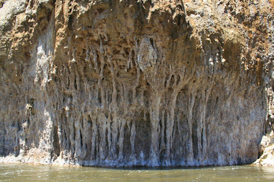
Unusual spring deposits at the Salt Banks.

An upstream view back towards the Salt Banks from Walnut Canyon. The scenery is fantastic.

Spring was in full bloom for us on this trip. I photographed this blooming cactus on a side hike up n Walnut Canyon.

On day three we first encountered the Ruin Granite, a body of rock that is worn smooth by the runoff on the Salt River. The granite was emplaced about 1,400 Ma at a depth of five to ten miles. It was then uplifted and eroded before the Apache Group rocks buried it, beginning about 1,200 Ma.

View upstream of the Ruin Granite gorge at the mouth of Canyon Creek, another marvelous Mogollon Rim drainage from the north. We traveled with another group from Ridgeway, Colorado for a few days.

View downstream to Canyon Creek Rapid in the granite gorge. Note how scoured the rocks appear above the river. Between January 21 and 24 of this year, the Salt River experienced an enormous flood that reached 90,000 cfs above the Roosevelt reservoir. We saw evidence for this tremendous flood everywhere on our trip.

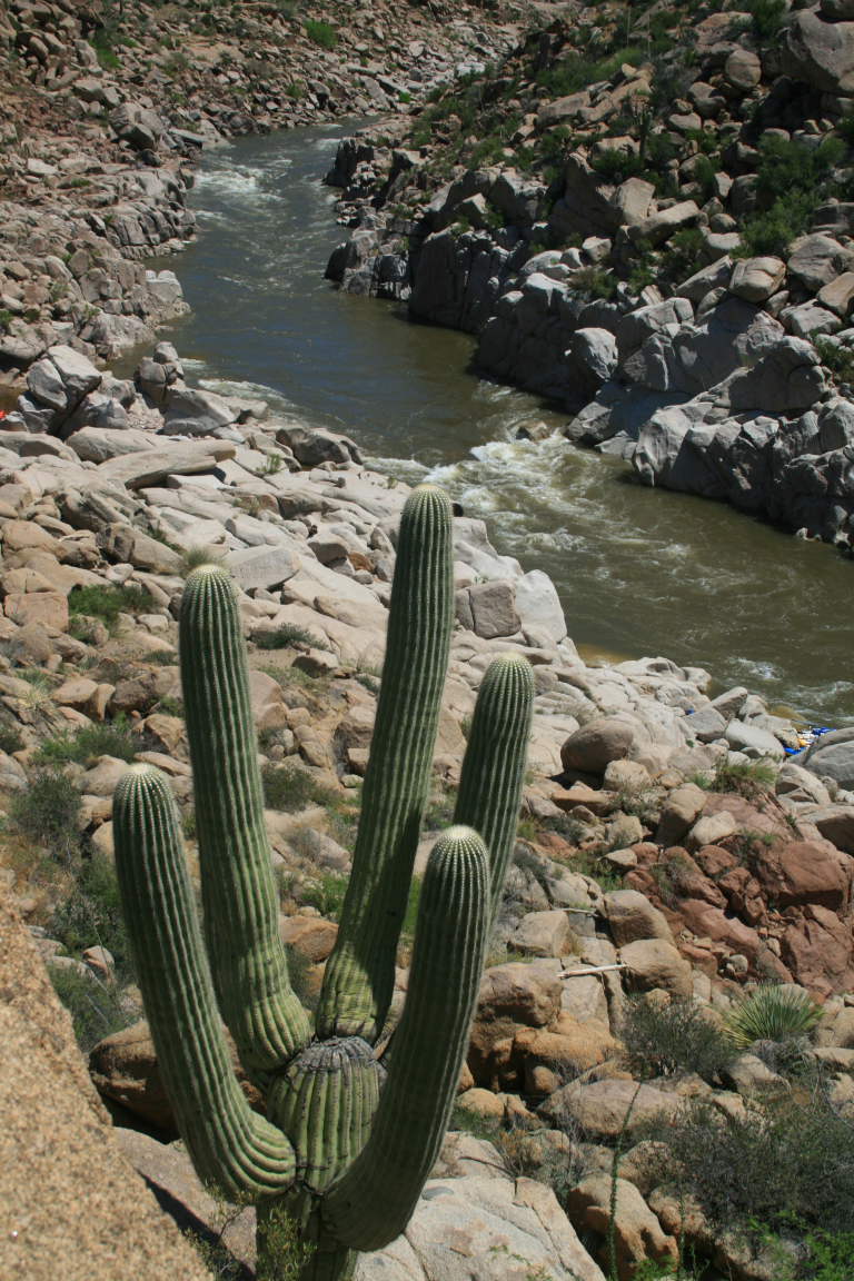
The juxtaposition of classic Sonoran Desert vegetation and scenery with a perennial river like the Salt is like no other river trip I know of (except the Salt's cousin, the Verde River). I must have taken over 200 photos of these enormous cactus near the river.

See what I mean!

The Ruin Granite is a very coarse-grained rock with well exposed crystals of orthoclase feldspar (pink), plagioclase feldspar (white), and quartz (milky). Here, a few stringers of epidote (pistachio green) were found.

Sculpted exposures of Ruin Granite up in Canyon Creek make for an other-worldly view.

Exiting the gorge above Gleason Flats, we got a view of majestic Canyon Creek Butte, capped by the Apache Leap Tuff, which was erupted about 18.5 Ma in a paleocanyon that trended northeast. More will be said about this Oligocene/early Miocene canyon later.

After three miles across the open country of Gleason Flats, the river enters another canyon cut into the Redmond Formation, a suite of metamorphosed ash flows that are the oldest rocks in the Salt River Canyon. They are dated at 1,750 Ma. These rocks, along with the overlying Hess Canyon Group, are the less-altered cousins of the Vishnu Schist in the Grand Canyon. Again, note the scouring of the gorge immediately above the river. We estimated that the water was over 30 feet higher during the flood than seen here. The noise must have been deafening. The power must have been unreal.

Lee paddling her canoe downstream from Eye of the Needle Rapid.

Redmond Formation sculpted by the Salt River above Black Rock Rapid.

A view of Black Rock Rapid from our scout vantage point on river right. We scouted more than 12 rapids in the course of our trip.

Gary paddles for a closer view of the Whitetail Conglomerate, an Oligocene/early Miocene (∼30 to 20 Ma) valley fill deposit that preserves an older canyon before the modern Salt River Canyon. Rivers in this area used to travel northeast and these gravels help to document that earlier drainage alignment.

Scouting Pinball Rapid with the Redmond Formation along the river.

Brian pulls on the oars of our raft as we negotiate the swirling currents of the Salt River.

Lee paddling beneath the upturned beds of the Hess Canyon Group. These are Proterozoic sedimentary rocks whose metamorphism was slight enough that we can discern their original bedding and depositional characteristics. The same rocks in the Grand Canyon were cooked and pressurized into schist and gneiss and it is more difficult to see what they were originally.

Downstream view to the narrow gap where Quartzite Falls is located. Note the upturned beds of the White Ledges Quartzite (Hess Canyon Group). The Salt River is having a difficult time excavating the river channel here through this resistant bed of rock. Thus, the falls are created where the river pours over the ledge. However, in the early 1990's someone dynamited the falls which are now runnable but still difficult to run.

Gary and Lee paddling in the open country near Horseshoe Bend.

The wind was blowing very hard this day nd I found an excellent example of adhesion ripples on the river bank. These form when dry sand blows across wet sand and they adhere the the surface creating this unusual pattern. Adhesion ripples are found in sandstones that are hundreds of millions of years old.

Rockinstraw Mountain (elev. 5385 ft.) as seen from Horseshoe Bend. It is capped by Apache Leap Tuff but is visibly downfaulted back towards the photographer. This faulting documents the progressive lowering of the Basin and Range to the southwest of the Salt River Canyon. This lowering is what caused the drainage reversal from the old northeast-directed flow in the paleocanyon to southwest flow in the modern Salt River.

Pinnacles of rock related to the eruption of the Apache Leap Tuff 18.5 Ma. Erosion by the Salt River has exposed this former vent for these Cascade-style volcanoes.

Close-up view of the pinnacles, which are now closed to all stopping because of nearby nesting bald eagles.

And just around the corner, we saw two of the eagles by the side of the river.

Can you stand it? Another view of the Whitetail Conglomerate just upstream from Coon Creek. The unsorted nature of the deposit (where boulders are mixed in with pebbles and sand) is striking and probably represents deposition in nearby alluvial fans within the old paleocanyon.

A casualty of the January 21 flood on the Salt River. This old giant was undercut when its substrate was removed in the flood. But small shoots of green leaves were seen growing out of the toppled tree.

Shh! A secret waterfall and pool located in Chalk Creek.

Another Sonoran Desert mastepiece along the lower Salt River run.

A baby saguaro cactus growing next to a crumbling boulder of Ruin Granite. In some areas, the plagioclase feldspars weather out of the granite, causing the orthclase and quartz to become liberated as grus on the desert floor.

View downstream to the Klondike Cliffs and the edge of the Salt River Canyon Wilderness. The ride of the cliffs is capped by the Apache Leap Tuff.

Bryan stands next to an old guardian that we estimated to be about 38 feet high. Wow!

The last narrows before the take-out are carved into the Apache Leap Tuff near the confluence with Pinal Creek.

The open country near the Highway 288 bridge, where the Roosevelt reservoir was constructed on the Salt River in 1911. It was a fabulous trip with good weather, food and company. I wish everyone could see it.
 A first view of the Salt River and its canyon near the US Highway 60 bridge, north of Globe, Arizona. The canyon is sometimes referred to as the "Little Grand Canyon". Shown are two of the first rapids, Bump and Grind (top) and Maytag (below). The rock cliff in the foreground is part of the Dripping Springs Quartzite (Proterozoic).
 Looking downstream from above Overboard Rapid. The rocks belong to the Proterozoic Apache Group, a sequence of strata time correlative with the Unkar Group in Grand Canyon. Black rock near the river is a diabase intrusive dated at 1,100 Ma, gold colors above this are Dripping Springs Quartzite, capped by whitish Mescal Limestone (with another diabase sill sandwiched in here), and Troy Quartzite capping the skyline.
 A wider view to the northwest. This canyon and river are exquisite landscapes that are rarely seen or visited in Arizona. The land north of the river belongs to the White Mountain Apache Indian Tribe.
 Bryan and I found this rather cryptic lava flow (at least from river level) perched well above the modern river channel but perhaps occupying an old alignment of the river bed. Dating of this flow might reveal the rate of downcutting for the Salt River here.
 A view of the lava flow from our camp at Grumman Rapid.
 After running Overboard Rapid on our second day, we entered a narrow gorge cut into the intrusive diabase. This magma forced its way between layers of quartzite and created a space for itself while in the subsurface. Grand Canyon exposes a similar diabase intrusion of the same age, lending credence to the idea that the Apache Group and Unkar Group rocks are related.
 Downstream view of the rocks above Cibeque Creek, a major side drainage off of the Mogollon Rim to the north.
 Gary paddles in front of the famous Salt Banks, a spring deposit of travertine and various salts that "erupt" right next to the river. Some believe that the Salt River was named for this spring deposit but a more likely story is that the river made agricultural fields salty throigh time.
 Overhang of colorful travertine above an alcove in the spring.
 Unusual spring deposits at the Salt Banks.
 An upstream view back towards the Salt Banks from Walnut Canyon. The scenery is fantastic.
 Spring was in full bloom for us on this trip. I photographed this blooming cactus on a side hike up n Walnut Canyon.
 On day three we first encountered the Ruin Granite, a body of rock that is worn smooth by the runoff on the Salt River. The granite was emplaced about 1,400 Ma at a depth of five to ten miles. It was then uplifted and eroded before the Apache Group rocks buried it, beginning about 1,200 Ma.
 View upstream of the Ruin Granite gorge at the mouth of Canyon Creek, another marvelous Mogollon Rim drainage from the north. We traveled with another group from Ridgeway, Colorado for a few days.
 View downstream to Canyon Creek Rapid in the granite gorge. Note how scoured the rocks appear above the river. Between January 21 and 24 of this year, the Salt River experienced an enormous flood that reached 90,000 cfs above the Roosevelt reservoir. We saw evidence for this tremendous flood everywhere on our trip.
 The juxtaposition of classic Sonoran Desert vegetation and scenery with a perennial river like the Salt is like no other river trip I know of (except the Salt's cousin, the Verde River). I must have taken over 200 photos of these enormous cactus near the river.
 See what I mean!
 The Ruin Granite is a very coarse-grained rock with well exposed crystals of orthoclase feldspar (pink), plagioclase feldspar (white), and quartz (milky). Here, a few stringers of epidote (pistachio green) were found.
 Sculpted exposures of Ruin Granite up in Canyon Creek make for an other-worldly view.
 Exiting the gorge above Gleason Flats, we got a view of majestic Canyon Creek Butte, capped by the Apache Leap Tuff, which was erupted about 18.5 Ma in a paleocanyon that trended northeast. More will be said about this Oligocene/early Miocene canyon later.
 After three miles across the open country of Gleason Flats, the river enters another canyon cut into the Redmond Formation, a suite of metamorphosed ash flows that are the oldest rocks in the Salt River Canyon. They are dated at 1,750 Ma. These rocks, along with the overlying Hess Canyon Group, are the less-altered cousins of the Vishnu Schist in the Grand Canyon. Again, note the scouring of the gorge immediately above the river. We estimated that the water was over 30 feet higher during the flood than seen here. The noise must have been deafening. The power must have been unreal.
 Lee paddling her canoe downstream from Eye of the Needle Rapid.
 Redmond Formation sculpted by the Salt River above Black Rock Rapid.
 A view of Black Rock Rapid from our scout vantage point on river right. We scouted more than 12 rapids in the course of our trip.
 Gary paddles for a closer view of the Whitetail Conglomerate, an Oligocene/early Miocene (∼30 to 20 Ma) valley fill deposit that preserves an older canyon before the modern Salt River Canyon. Rivers in this area used to travel northeast and these gravels help to document that earlier drainage alignment.
 Scouting Pinball Rapid with the Redmond Formation along the river.
 Brian pulls on the oars of our raft as we negotiate the swirling currents of the Salt River.
 Lee paddling beneath the upturned beds of the Hess Canyon Group. These are Proterozoic sedimentary rocks whose metamorphism was slight enough that we can discern their original bedding and depositional characteristics. The same rocks in the Grand Canyon were cooked and pressurized into schist and gneiss and it is more difficult to see what they were originally.
 Downstream view to the narrow gap where Quartzite Falls is located. Note the upturned beds of the White Ledges Quartzite (Hess Canyon Group). The Salt River is having a difficult time excavating the river channel here through this resistant bed of rock. Thus, the falls are created where the river pours over the ledge. However, in the early 1990's someone dynamited the falls which are now runnable but still difficult to run.
  Gary and Lee paddling in the open country near Horseshoe Bend.
 The wind was blowing very hard this day nd I found an excellent example of adhesion ripples on the river bank. These form when dry sand blows across wet sand and they adhere the the surface creating this unusual pattern. Adhesion ripples are found in sandstones that are hundreds of millions of years old.
 Rockinstraw Mountain (elev. 5385 ft.) as seen from Horseshoe Bend. It is capped by Apache Leap Tuff but is visibly downfaulted back towards the photographer. This faulting documents the progressive lowering of the Basin and Range to the southwest of the Salt River Canyon. This lowering is what caused the drainage reversal from the old northeast-directed flow in the paleocanyon to southwest flow in the modern Salt River.
 Pinnacles of rock related to the eruption of the Apache Leap Tuff 18.5 Ma. Erosion by the Salt River has exposed this former vent for these Cascade-style volcanoes.
 Close-up view of the pinnacles, which are now closed to all stopping because of nearby nesting bald eagles.
 And just around the corner, we saw two of the eagles by the side of the river.
 Can you stand it? Another view of the Whitetail Conglomerate just upstream from Coon Creek. The unsorted nature of the deposit (where boulders are mixed in with pebbles and sand) is striking and probably represents deposition in nearby alluvial fans within the old paleocanyon.
 A casualty of the January 21 flood on the Salt River. This old giant was undercut when its substrate was removed in the flood. But small shoots of green leaves were seen growing out of the toppled tree.
 Shh! A secret waterfall and pool located in Chalk Creek.
 Another Sonoran Desert mastepiece along the lower Salt River run.
 A baby saguaro cactus growing next to a crumbling boulder of Ruin Granite. In some areas, the plagioclase feldspars weather out of the granite, causing the orthclase and quartz to become liberated as grus on the desert floor.
 View downstream to the Klondike Cliffs and the edge of the Salt River Canyon Wilderness. The ride of the cliffs is capped by the Apache Leap Tuff.
 Bryan stands next to an old guardian that we estimated to be about 38 feet high. Wow!
 The last narrows before the take-out are carved into the Apache Leap Tuff near the confluence with Pinal Creek.
 The open country near the Highway 288 bridge, where the Roosevelt reservoir was constructed on the Salt River in 1911. It was a fabulous trip with good weather, food and company. I wish everyone could see it.


