Our trip is now at its end and I am flying home to Flagstaff. Northern Arizona is apparently in the grips of a cold, snowy winter. My three week interlude to a summer in South America is coming to an end but I return with tanned skin, a new appreciation of the wonders of our sister continent, and 10 extra pounds (yes, that’s 1/2 a pound a day gained on the trip and time for a serious diet!) I’m hopeful the weight will go but that the memories will last.
At Sachsaywuman Ruins, Cuzco,Peru
As we flew again over Cuba on the way to Orlando, I did not hear any encoré comments from Mortimer or Margaret about lobbing a few bombs Fidel’s way. These trips are perhaps too intense and demanding to elicit much emotion at a time like this. Each of us who participated in this journey could use a vacation after this whirlwind adventure. But there’s no doubt the trip was a succes in every possible way. The diversity and variety of the stops was astounding, the weather was mostly perfect, and all went off without a single hitch. TCS is the be commended for their preparation and attention to detail in these expeditions. It went off flawlessly.
Most everyone really seemed to enjoy the trip, perhaps more so than other trips I’ve been on. There were of course the usual negative comments from a very few about some of the stops. The Amazon was not a favorite for many in our group but I believe the rain we encountered there may account for much of this feeling (and the fact that the tropics are simply a difficult destination for most North Americans). But if one is to continue in this line of work (as I will), you simply cannot let the bad-vibbers get you down. They'll always be around no matter how hard you may try to get them to see things in a different light.
My final comments to the group are usually the same - keep your eyes and hearts open to change, expect the unexpected, go with the flow. For folks in this day and age of cell phone calls from Patagonia, this can be a huge undertaking. We are told incesantly to “take control of our lives”. On a trip such as this, it seems to me that those who want to take a trip are not as richly rewarded as those who let a trip take them. Africa begins in just six weeks! It's home to Helen for now!
Adventure and foreign travel, philosophical and scientific musings, geology and landscapes, photography and earthly explorations.
Wednesday, January 30, 2008
Lima, Cuzco, and Machu Picchu, Peru - January 26 to 29, 2008
Lima’s Cathedral on the Plaza de Armas, where Francisco Pizarro lies buried following his conquest of Peru
The Pacific coast in the Mire Flores neighborhood of Lima. Many on our trip commented that it looks like the coast in Santa Monica, California, although this cliff is higher and in a much drier environment. Lima sometimes goes years without rain
A modern and lively shopping center is a popular meeting place for these young “gothic” Peruvians. They enjoyed having their picture taken and posed proudly without any coaching whatsoever
Mira Flores Gothic. Cool!
The remains of Qorikancha, the Inca Sun Temple in Cuzco, Peru. These limestone rocks weigh many tons are were carved by the Inca with only wood wedges and water! Francisco Pizarro subdued the Inca and built a church on top of these foundations. The story of the Inca and their conquest by the Spanish makes for fantastic reading
View of Cuzco, Peru with the Plaza and cathedral visible in the center
Cuzco, Peru - Cathedral and Fountain
Quechua women in front of the Inca Sun Temple. Only one sol (33 cents) for a picture
Our private train took us three and a half hours to the Urubamba River and the ruins of Machu Picchu - recently named as one of the new Seven Wonders of the World. These porters greeted us as we boarded the train
The spectacular ruins of Machu Picchu, Peru! They are located on a high ridge above the winding Urubamba River, a major tributary of the Amazon. Majestic Huayan-a-cachu in the background - I climbed this peak in January, 2000 on my first TCS Jet Trip. Access now is quite restricted
Among the ruins of Machu Picchu. This important Inca site was constructed and occupied between 1450 and 1540 AD. It was never found by the Spanish although they heard from the Inca of its existence
You can see the reason why the Spanish did not find Machu Picchu. It is located in a seemingly inaccessible part of the Andes Mountains. The terrain is severely oversteepened and covered in dense jungle vegetation. The Urubamba River and its stupendous canyon can be seen with our train tracks barely visible below for scale
When Hiram Bingham was led to this site in 1911 by local Indians, he was the first outsider to lay eyes on the Inca’s hidden city. During its occupation, 600 people called it home but over 25,000 were utilized in its construction, quarried from nearby granite rock
The ruin that Hirum Bingham found was blanketed by the jungle. A year later he returned as part of a National Geographic expedition and began its excavation from its green veneer
Rain at Machu Picchu did not dampen our spirit. The site is simple too spectacular to be put off by it. It adds a sense of mystery and intrigue. Some of the rooms have been restored with thatch roofs
Parting shot of Machu Picchu. Visitation is bound to increase significantly with its new designation as one of the world’s Seven Wonders. The others on the list include Chitchen Itza, Yucatan; Christ the Redeemer Stature, Rio de Janeiro; the Coliseum, Rome, the Great Wall, China; the Pyramids at Giza; and Petra in Jordan
Galapagos Islands - January 23 to 26, 2008
I feel so lucky! It’s my second visit to the Galapagos in the last two months. This time we visited the older, more wildlife rich eastern islands of Española, San Cristobal, and Santa Cruz. Check out these photo’s!
A giant land iguana that was sitting in the shade of a prickly pear cactus at the airport terminal. These are fantastic lizards that are about two feet long and stand almost a foot off the ground
The Blue Footed Booby is something that everyone loves to see. Why are their feet blue? “Why not”, was the answer of our local guides
Close up showing the feather details of a Blue Footed Booby on Española Island
The dance of the Blue Footed Booby is a pre-mating ritual. The male and the female lift their feet repeatedly and squawk loudly as the dance commences
Seal and zodiac at Gardner Bay on Española Island - January 25, 2008
A couple of our passengers enjoying the view of the Galapagos Giant Tortoise in the highlands of Santa Cruz Island - January 26, 2008
Giant tortoises in pool
“Love is in the air!”, exclaimed our local guide as we rushed over to catch two giant tortoises mating. (As it turned out we didn’t need to rush). The male has a concave shell on his underside that allows him to mount the female
Our jet on the tarmac at the airport in Baltra, Galapagos
Tuesday, January 22, 2008
Off to the Galapagos Islands!
I'll be on board the Explorer ship from January 23 to 26, and so there will not be any additions until I arrive in Lima, Peru on the afternoon of the 26th. Stay tuned.
The Atacama Desert - World's Driest
After flying half way up the length of the South American continent, we landed in Calama in northern Chile. Chile is the Earth's longest country and if it were transposed latitutinally to the north, it would stretch from Ketchikan, Alaska to Acupulco, Mexico! It goes from glaciated mountains in Patagonia, to the temperate wine growing region near Santiago, to the Atacama Desert, which is the Earth's driest. Some places here do not receive rain for decades!
These are the Andes Mountains as we approach Calama in our jet.
Look at this - 8,000 feet above sea level and not a hint of vegetation anywhere. 8,000 feet and nothing but gravel!
A fantastic angular unconformity. The rocks below were once flat-lying sediments. They were tilted to vertical during the uplift of the Andes. Then they were eroded flat before the upper layers buried them. Scenes like this inspired original geologic thinking in humans.
2020 Update - The lower brown and upturned beds belong to the San Pedro Formation, shale, sandstone, conglomerate, gypsum and salt deposited in a playa environment. It is Late Oligocene to Miocene in age. It is overlain by the Vilama Formation of likely Pliocene age. It is composed of silt, sand, and gravel deposited by streams out of the Andes Mountains.
Submitted by fellow geologist Paul "Geoman" in Texas
Atacama ghosts posing as pillars of salt. This is part of the Salt Range.
I visited the world's highest geyser basin on Tuesday. This is at 13,000 feet and the geysers were spectacular!
This is a boiling mud pot, reminiscent of Yellowstone. There are at least 50 to 60 geysers constantly erupting in this field.
Awesome thermal structures in El Taito geyser field. It started out cloudy but then the sun made its way through the mist.
The high Andes in the background of the geyser field rise to over 19,000 feet. The snow is unexpected however considering it is summer down here.
Just another awesome Andean volcano with summer time snow. This one is called Sarécabur and at 19,500 feet, it forms the international bounday with Bolivia. The Andes and the Atacama have received a lot precipitation recently.
Vicuña's are related to llama's and I saw dozens of them running across the altiplano as we drove home from the geyser field.
Sunday, January 20, 2008
Perfect Weather in Patagonia! - January 18 to 20, 2008
Explorer Jet touched down in the frontier town of Calafate, Argentina on Friday under clear skies and little to no wind. These are fairly rare conditions in this part of the southern "cone" of South America. Enjoy these pictures of a place still very little known but with huge surprises.
- As Explorer approached Calafate Airport, the glacially-fed Santa Cruz River was seen snaking towards the Atlantic Ocean.
- This is the Perito Moreno Glacier which advances repeatedly to dam a river upstream from it. It is a huge mass of moving ice. The face of the ice is 200 feet high!
- Detail of an ice pinnacle or serac on the Perito Moreno Glacier
- My picture at the ice front. This one is for Helen!
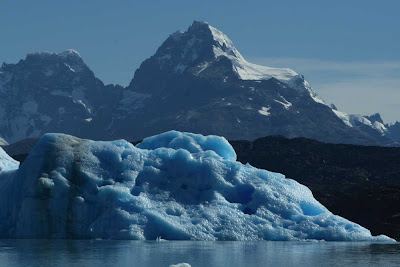
-A boat ride on Lago Argentino brought us towards massive icebergs that floated on the lake.
- These are some of the mountains that surround Lago Argentino. Although they are "only" about 6,000 feet above sea level, they are quite rugged, full of ice, and spectacular!
- More icebergs!
- We visited an estancia or ranch and enjoyed some refreshments.
- The Cristina River flows next to the estancia. THe water color was unbelievable!
- At the end of a long day of exploring Patagonia, I shot this photo of some highly contorted sedimentary rocks. These are part of the Cerro Toro Fm., deposited in the Atlantic Ocean about 80 million years ago. They were folded after that as the Andes were uplifted. Look at those folds!
Friday, January 18, 2008
Uruguay and Colonia de Sacramento
On Thursday we boarded a high speed ferry boat for a 45 minute trip across the Rio de la Plata and into the past in the little village of Colonia de Sacramento in Uruguay
They have all kinds of funky art in the streets - like this old car where soil has been placed so that a tree can grow out of it. Nice touch on the art!
Many of the restaurants are open air since this is a water town and the weather is warm this time of the year. I especially liked the colorful decor of this one that beckoned street walkers
THe Spanish colonial style is attractive.
Subscribe to:
Posts (Atom)