Thursday, January 31, 2013

A Trip "Around the World" Begins on February 3

The time has come! In just a few days I will embark on another TCS & Starquest Expeditions Private Jet adventure. This one will take me around the world in a 757 luxury jet. I invite you to tune in to Earthly-Musings all throughout the month of February to read my reports and see the photographs from this extraordinary journey.

From a previous trip in 2009, the Explorer jet refueling on Ascencion Island in the middle of the Atlantic Ocean

Beginning in Orlando Florida, we make our way south to Lima, Cuzco, and Machu Picchu Peru, then across the western Pacific to Easter Island. With a short fuel stop in Tahiti, we then travel to American Samoa and Australia and the Daintree Rainforest. Next up is Ankor Wat in Cambodia, the Taj Mahal and Jaipur India. We then set foot on the continent of Africa and make three stops - Serengeti, Valley of the Kings in Egypt, and Fez. Morocco, before returning back to Orlando on February 24. You can see the entire itinerary by clicking the link here and follow along.

Thanks for checking in with me as I travel Around the World!

Wednesday, January 30, 2013

A Trip to the (Booming) Eagle Ford Shale Petroleum Fields

Here's something a little different. The geology I normally am involved with has little to no economic benefit. There are no resources extracted from studying the origin of ancient landscapes or how the Grand Canyon was carved. I recently visited San Antonio, Texas where right now, a modern-day oil boom is underway to the southeast of that proud city. New technology has allowed petroleum companies to drive their drills 11,000 feet beneath the desert floor to a rock unit known as the Eagle Ford Shale. I recently got to visit a friend who owns a small ranch in Karnes County, right in the middle of this bonanza. I took some pictures while on Joe Orr's ranch. First though, a little background. The oil "play" is shown in the graphic below
Texas and the area where the Eagle Ford Shale play occurs
The Eagle Ford Shale is a mix of sandstone and limestone that records a transgression of the sea about 94 to 89 million years ago (Cenomanian/Turonian is the stage). Below is a paleogeographic map showing the setting during Eagle Ford time. Eagle Ford strata are overlain disconformably by the Austin Chalk.

Paleogeography about 95 million years ago. Map by Ron Blakey, Colorado Plateau Geosystems
Regionally, the Eagle Ford shale consists of two depositional units: a lower transgressive unit dominated by dark shale, and an upper regressive unit consisting of shale, limestone, and siltstone.  Eagle Ford microfacies exhibit distinctive sedimentological aspects and have source rock characteristics that vary systematically within a sequence stratigraphic framework. The transgressive rocks have optimum oil source potential, whereas the overlying regressive shales are gas-prone. Transgressive Eagle Ford strata represent poorly oxygenated low-energy, marine environments. In contrast, overlying regressive Eagle Ford rocks accumulated in higher energy, well-oxygenated, shallow marine environments.

Production has soared recently in the Eagle Ford Shale!

The gas flares at night have been captured in this stunning night time photograph (Image courtesy of Scientific American)


Lastly, the major determinant on who gets to play in the voluminous oil money game, depends on the depth of the shale beneath your land. In the graphic below, black represents the surface outcrop pattern of the Eagle Ford. The unit then dips to the southeast and is just beneath the surface in San Antonio. It gets progressively deeper and at about 11,000 to 12,000 feet, the shale produces liquid oil when fracked. Deeper positions yield wet gas and eventually dry gas. All of this geology might be confusing to cattle ranchers but when big oil comes a knockin' the royalty checks start rockin'.
Graphic courtesy of the Energy Information Administration
Now for a tour of the Orr Ranch!

EOG Resources stands for Enron Oil and Gas. It was spun off of the main company before it went down the tubes.

This is the thornbrush desert of south central Texas. There is lots and olots of prickly pear cactus and many species of mesquite.

The Orr Ranch used to be a cattle spread with occasional deer hunting as well. Here is a hunting blind constructed on the ranch.

The old barn on the Orr Ranch. The original ranch house was damaged in a storm and water leaked through the roof so it does not exist anymore.

Here is our gracious host, Joe Orr. His great great grandfather was William G. Butler and he first established his ranch here in the 1850's. Originally at about 75,000 acres, Joe currently has about 1,600 acres on two parcels. Joe is standing in front of a 30 foot deep trench that was the site of a uranium mine during the Cold War. South Texas was the site of much uranium mining, which was dug during the Cold War. See how the uranium was formed here.

Just around the corner we got our first glimpse of one of the wells on the ranch. All of the oil infrastructure you see on this blog has been here for only two years or less.

The necessary warnings to any visitors who happen to chance by

Pipelines are going in everywhere and they serve to connect the various wells into gathering stations, where tanks get filed with crude oil. Then  trucks come by and pick up the crude for refining in Corpus Christi.

A pump-jack at work on the Orr Ranch. This design has not changed very much in all the years of oil drilling. A short history of the pump-jack can be found here.

And another! All told there are 16 wells on Joe's land with another nine slated for instillation sometime soon. Joe is still in a kind of shock about the whole affair. Like myself, he worked for many years as an international guide with 10 years working for Mt. Travel/Sobek in Copper Canyon, Mexico. He really did not have ranching in his blood and inherited the land from his mother when she passed away. The the oil people came knocking about three years ago. It turns out that this relatively small piece of real estate was ideally suited for drilling in the Eagle Ford Shale. What made it possible was the development of fracking technology, whereby extreme pressures are injected into shale rocks releasing the trapped oil. Everyone knew there was oil in the Eagle Ford for decades - there just wasn't any way to get it out. An extensive discussion of the pros and cons of fracking can be found here.

Our "tour group" consisted of Leah M. Joe O., and Helen R.. I took the picture.

This is the Wilson County Courthouse built in the 1880's. Texas has some really beautiful courthouses but this one has some structural problems and is essentially out of commission. However, perhaps the nearby oil boom will allow for the rehabilitation of this historic building. Joe is certainly helping many worthy causes with his new found wealth. There is always a silver lining in any story, if only we know how to find it.

Sunday, January 06, 2013

Bringing In The New Year At The Bottom Of The Grand Canyon

Helen and I spent 6 days inside the Grand Canyon between December 27 and January 1. It was downright cold at the bottom but still 20 degrees warmer than out on top. Lots of fun - lots of great winter light for photos. I never tire of looking at these rocks. Have a look.

The canyon danced with winter clouds filled with snowflakes as we began the hike down about 1 PM

It was all magical - the light, the clouds, the tilted Supergroup poking up through Tapeats Sandstone

Snow always brings out the regularity of the layering of strata in the Southwest

And then, just as fast, it all hides momentarily in a veil of cloud

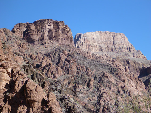
Subdued colors on O'Neill Butte (Supai Group) and the Red and White switchbacks in the Redwall (lower right)

The lights come back on a little farther down the trail

At the top of the Redwall, the trail swings to the west and displays another glorious sight

Zoomed in, we see the Cambrian Tapeats Sandstone (left) capping the Precambrian schist. Note how the Tapeats pinches out to the right with orange Hakatai Shale creating a paleo-high that precluded deposition of the Tapeats in the upper center of the photgraph. I just love paleo-highs! Pre-existing topography makes me happy!

That's my campground down there behind the rainbow

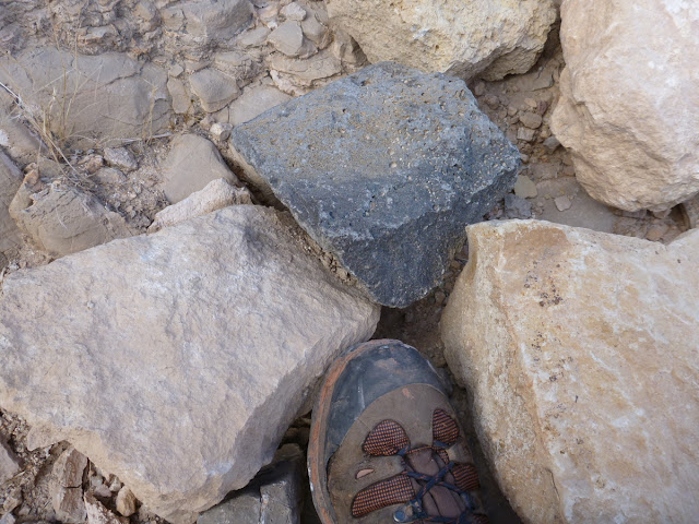
Hey? What is this piece of vesicular basalt doing along the trail in the Redwall Limestone? Is the treail crew bringing exotic rocks into the canyon? I saw three of these!

Eye-level view of the Grand Canyon Supergroup rocks across the gorge of the Colorado River

Self-portrait taken about 3:30 Pm on the Tonto Plateform at the Tip-Off

Finally, Bright Angel Creek delta poking out into the channel of the Colorado River! Look at how all of that debris came pouring out of the canyon to constrict the larger channel of the river. Awesome!

While staying at the bottom, there is ample time to explore the local environs. From the delta near the river, this is a view up to Sumner Butte (Redwall mass on the right) and a lower unnamed promontory of the Tapeats Sandstone. I've always wanted to go out onto that promontory that looms over the delta area and today was the day.

We took the Clear Creek Trail up and got a good view of Phantom Ranch below. Here it was the 4th to last day in December and the cottonwood trees looked like the hight of autumn anywhere else.

Farther on the trail, the Kaibab Bridge was visible across the river

And looking to the east, we saw the deep defile of the Inner Gorge upstream on the river above Phantom Ranch

A downstream view. Everywhere we looked the light, color, and textures were brilliant

Finally, we left the trail and headed west across unbroken terrain. This is the top of the Tapeats Promontory (a new name!). Across Bright Angel Creek see some more grand paleo-topography. At eye-level on the far left and far right are blocks of Grand Canyon Supergroup, the upturned edges of this imaginary saucer. In the middle, is the Tapeats Sandstone, filling in the space between these two paleo-highs. See the training graph below.

Here is the same photo with all pertinent features labeled. Compare with the photo above to experience how a geologists mind works when they look out on the landscape of the Grand Canyon. Also, see Dr. Jack Share's excellent explanation of the faults in this area at this link.

Wayne, Helen, and Amanda in the back of the house at Phantom Ranch on a celebratory night. Photo courtesy of Sueanne Kubicek.

Partaking of the smoked trout at the Ranch. Photo courtesy of Sueanne Kubicek.

A New Day. A New Year. 2013 arrives but these ripples in the Hakatai Shale record one New Year's Day some 1,250 million years ago. Well, why not New Year's Day. Aren't they beautiful!

Up the Kaibab, a last look at Sumner Butte and its older brother, Zoroaster Temple, capped with a thin remnant of the Seligman Member of the Toroweap Formation

It was a cold and beautiful start to the New Year. Here, a Phantom packer and mules bring more beer to Phantom Ranch!

Stromatalites present in the Hakatai Shale along the Kaibab Trail

The Grand Canyon - natures masterpiece. Happy New Year everyone!

Thursday, January 03, 2013

My 2013 Geology Trips On The Colorado Plateau

The snow-capped La Sal Mountain laccolith, seen from the Junction Butte Trail in Canyonlands National Park

What could possibly be better than traveling to some of the most scenic places on the Colorado Plateau with your own personal geologist and guide to show you around? Not much I'd say! The colorful earth history on display here will come alive on these two trips that I am leading in April, 2013. Please join me as the Museum of Northern Arizona offers these Ventures programs to Grand Staircase-Escalante National Monument and another to Arches and Canyonlands National Parks.

Calf Creek Falls in Grand Staircase-Escalante National Monument
Each trip is a hotel-based excursion that offers many short day hikes and drives to some of my most favorite southwestern localities. Even if you have visited these areas on your own before, you will be amazed at how much there is to see and learn when you have a dedicated and knowledgeable guide to show you around. On each trip we will spend four nights in a local lodge (provided) and then venture out into the wilderness to explore geology, human history, and scenery.

The Museum of Northern Arizona has been offering Ventures trips since 1977 and I have been involved with the program since 1982. The Grand Staircase-Escalante trip can be booked here. And the Canyonlands and Arches trip can be booked here. I hope to see you on one of these trips in 2013!

Slot canyon exploration in Grand Staircase-Escalante National Monument


Partition Arch in Arches National Park