In late July I traveled up to Canada eh, embarking on an invitation to hike British Columbia's West Coast Trail. This 75 km long (47 mile) track is world famous for its ladders, swinging bridges, cable car river crossings, slippery log bridges, and tree root infested mud. It was awesome! Totally different from what I am used to as this place does green like the Southwest does red. Take a look at this very green and interesting place.
I first had to get myself up to the Great North and flew on Alaskan Airlines to Bellingham Washington. We flew right over the Grand Canyon. Canyonphiles will notice the Colorado River flowing bottom to top toward Toroweap Overlook at top right. Fishtail Mesa visible in the lower right, Kanab Creek above it and the Sinyala fault runs away from the photographer in the center. Nice view!
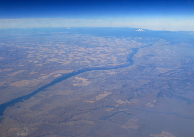
Later, we crossed another great North American river, the Columbia. Note the snow-capped crest of Mt. Hood in the diatance with Mt. Jefferson barely visible left of it.
As we began our descent into Seattle, a line of Cascade Mountain volcanoes came into view. Goat Rock is likely in the foreground, next is Mt. Adams (center), then Mt. Hood and last is Mt. Jefferson. These volcanoes mark a line where the Juan de Fuca plate subducts deep enough beneath western North America (about 60 to 100 miles down) where it melts sending molten volcanic rock toward the surface.
Mt. Ranier was next and this massive volcano is labeled as one of North America's most dangerous. This is not so much for its eruptive potential, which is great, but more because of rock weathering from volcanic gas that weakens and destabilizes the rocks that make up its bulk. It's rotten rock in many places and subject to gravitational collapse. In fact, looking at the relatively snow-free "hollow" in the center of this image you can see where a large part of the volcano flank has previously slipped and been gouged out of the mountain.
Arrival in Bellingham, where my friend Karen picked me up for the 2 hour drive to Vancouver city.
By that evening, we were on the ferry across the Strait of Georgia to Vancouver Island.
The West Coast Trail is within the boundaries of the Pacific Rim National Park. With the huge amount of commercial logging that occurs on Vancouver Island, this thin strip of coastal wilderness preserves one of North America's great rainforests. Only about 7,000 persons per year are allowed to hike the trail! A reservation system is in place and the permits go quickly with 80% going to Canadians. However we saw many international hikers from Germany, Holland, China, and elsewhere. I felt fortunate to be invited.
All hikers must attend a 45-minute slide presentation on trail etiquette, tide schedules, and learning about the many obstacles that cause numerous evacuations from the trail. A little more than halfway through the season, 34 hikers had already been removed involuntarily from the park due to injury.
Let the hike begin! On July 31 we passed kilometer marker 75 on the trail and headed north. Our goal was Thrasher Cove 7 km away. This southern end of the trail was the most difficult. It was not the up and down so much but the various obstacles that lie in the path.
Like this - a tangle of tree roots that seem to shackle your ankles and cause your boots to slip on the roots if they are wet. Hiking sticks are a good idea as I learned on this day - my only one in which I did not use the sticks.
Then there are the ladders. I am sure if that if T-shirts were made for the West Coast Trail, they would have an image of a wooden ladder that is 65 rungs long perched precariously on the side of a cliff. This was the first of about 70 ladder complexes. I found the ladders challenging but fun and they are definitely one of the signature aspects of the trail.
I was dead-dog tired when we arrived at Thrasher Cove some 7 hours after the start of the hike. This was a small patch of sand that was occupied by about 50 other campers. The WCT made a huge impression on the first day. It was the combination of steep up and down, numerous ladders and boardwalks, slippery roots and mud bogs, all part of the routine slogging that the trail is famous for.
The next day we climbed out of Thrasher Cove retracing our steps on one of the steepest sections of trail encountered. Here Karen pauses on a "switchback" suspended on downed logs.
A various localities, the trail intersects the coastline and provides wonderful views - if it is not foggy. Incredible to think that if one set sail from here to the next big piece of land, it would take you almost 8,000 miles to the shores of Australia. This is land's end!
The West Coast Trail was built in 1907 and first called the Dominion Lifesaving Trail. It runs along a part of the Pacific coast known as the "Graveyard of the Pacific," where hundreds of shipwrecks came ashore. The trail was envisioned as a lifesaving route for shipwrecked sailors; One notable shipwreck occurred in January, 1906 when the SS Valencia ran aground in very foul weather. An incredible account of this story can be read here.
Numerous bridges cross the many streams and this one is a relatively new one.
Here a western cedar tree that became detached from its root ball, slid down the slope to become perched above a ravine. The photgraph was taken from a bridge on the trail.
Here is a short ladder with a platform to an elevated boardwalk. I thought this was particularly representative of the infrastructure on the trail. Notice the missing rung - these sections often proved difficult with a 40 pound pack on your back.
Through the matted forest, over the roots of trees, with routine slogging in the mud.
Another ladder descent.
On the second night we arrived at Camper Bay. The nearby shore exposed an outcrop of greywacke, defined as a "dirty" sandstone that is often deposited in oceanic trench settings. I'll have more to say about the geology later in the post. This outcrop had a fantastic texture known as tafoni.
During the night came our only rain of the trip. It began about 2 a.m. and we woke up to fog and droplets of rain. With miles to cover on the last hard section of trail, we had to move early and were on the trail by about 7 a.m.
The tangled trail with rain. These exposed roots are slicker than a squashed slug and were often located in the right of way. Hiking sticks were a big help but these sections proved to be slow going.
Parks Canada does a lot of trail work, which oftentimes involves cutting steps into fallen logs which cross above the streams sometime 20 feet. Some logs have no steps. In the rain it was slick so the going was slow.
Beautiful side stream.
The descent into Logan Creek was one of the most amazing on the whole trip. Two sets of long ladders lead down to a narrow, one lane suspension bridge above the creek. The upper ladder leaned to the left, giving a feeling that it was about to topple in that direction.
The view from below showing how some of the ladders are built at low angle and on exposed cliffs.
On the suspension bridge. These felt much safer than some of the bridges we encountered in Nepal but that doesn't mean that they didn't move while walking on them. The height above the creek here was about 120 feet.
Hikers step right from the wobbly bridge onto a tall ladder complex that seems to reach into the sky. This single span contains about 55 rungs and makes for an exhilerating ascent.
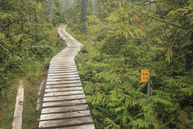
Passing kilometer 54 through a long bog, suspended on boardwalk. This was like walking on air!
An especially gooey section of trail. Apparently, when the island receives its normal compliment of rain, these pits of mud are known to suck hikers in to their knees or more. We wore gaiters on each day to keep the mud off of our legs.
Third nights camp at Walbran Creek. This concludes Part 1 of my hike on the West Coast Trail. we had hiked 23 kms. in three days and the hard part was behind us.


I always kinda love that the West Coast Trail is the upgraded, hiker-friendly version of the original Dominion Lifesaving Trail for shipwrecks. Can you imagine hiking out injured with no supplies, and having that be an improvement over the days-before-trail?
ReplyDeleteReally enjoying these photos- the following is for your viewers in earthquake fault zones-
ReplyDeleteEarthquake Precursors- There are numerous phenomena that precede large earthquakes:
1) Lightning-like discharges on the ground in fault areas
2) Water changes- ponds or lakes suddenly drain, water wells suddenly fluctuate up or down 10-20 ft, water becomes cloudy, has bubbles, smells sulfur-like, changes in temperature.
3) Unusual Animal Behavior - dogs howl uncontrollably, deep water fish species show up in shallow water, cats move their kittens outdoors, predator acts subdued in the immediate vicinity of prey, decrease of milk production in dairy cows
Attachment behavior- animals stick close to owner.
Frantic Escape Behavior - horse kicking a hole in stall door, pig jumping over a fence, fish jump out of water, mass migration of animals- snakes, rats, centipedes, worms, beetles, frogs.
4) Radon fluctuations- readings usually found in house basement
5) Changes in plants - unusual winter blooming
6) Foreshocks - smaller earthquakes- check USGS latest earthquakes, 2.5M+ or 4.5M+ for a given area.
-Info found in: "Unusual Animal Behavior...", Yamauchi at al., Animals(Basel), 2014 Jun; 4(2):131-145// "When The Snakes Awake" Helmut Tributsch, mitpress c1982// USGS website- earthquake.usgs.gov>animal_eqs
***If you observe the above events in or near a fault zone, contact your friends and determine if they have seen them also. If that's the case, grab a tent, a "go bag" previously prepared with food, water, toilet paper, flashlight and go outside.
Then upload video, photos or text of events to the web.
Feel free to contact Matt Maddox at astrosymm@gmail.com