For about a week, I toured the North Island of New Zealand with ten travelers on a Smithsonian Journeys adventure called
Journey Through New Zealand. The North Island is where volcanism, geysers, mud pots, and hot springs play an oversized role in shaping this very active landscape. We visited and witnessed many of the features left behind by these dynamic forces.
This is a true color satellite image of New Zealand on a relatively rare cloud-free day. Blueish Lake Taupo is clearly visible in the center of the North Island and the white spine of the snow-clad Southern Alps is also obvious on the South Island.
Zooming in on the same image to the North Island with our stops listed. I flew internationally into Auckland and traveled overland to Rotorua, Lake Taupo, Napier, and the capital at Wellington.
Auckland
A view of the Central Business District (CBD) of Auckland from across Waitemata Bay at Devonport. The view is to the southwest. Auckland was built within a basaltic volcanic field that is still active! This photo is from my trip in 2017 to New Zealand.
A slide from my lecture to the group. Basaltic volcanism began here about 250,000 years ago. This image, from Geoffrey Cox's book "
Fountains of Fire" shows the landscape around Auckland before volcanism began and during the Ice Age, when sea level was about 300 feet lower than present. (The modern shoreline in Auckland can be seen as the faint dashed line). I have annotated the future CBD (shown in the photo above this) and the International Airport where I arrived. Note that the Waitemata River in the top of the diagram flows east into the Pacific Ocean (left to right), but the Manukau River flows opposite this towards the west and into the Tasman Sea.
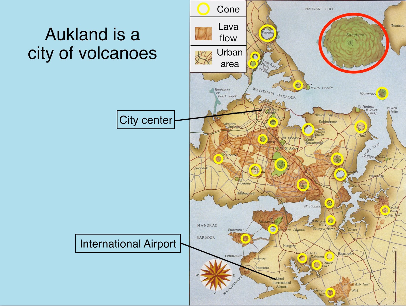
Each yellow circle represents one of the approximately 50 scoria cones located in central Auckland (not all 50 are within this image). The city center and international airport are also shown for reference to the previous diagram. The red circle in the upper right is Rangitoto Island and it is the most recent of the volcanoes to erupt - only about 500 years ago.
This is a view of Rangitoto Island from the top of Mt. Victoria in Devonport (one of the oldest volcanoes in this field). This photo is from my trip in 2017 to New Zealand.
The formation of Rangitoto Island with Maori people watching from the future site of Auckland city. Image used from "
Fountains of Fire".
Drive South
Heading south, we passed
Mt. Pirongia, a late Pliocene-Pleistocene basaltic center. The various peaks show basaltic vents on the volcano, now inactive. A native forest can still be found here. New Zealand was a land of unique wildlife and flora inherited from its separation with the Gondwana supercontinent. However, the introduction of exotic mammals and other pests, begin Ning with the Maori about 800 years ago, decimated native bird populations, with about 40% of endemic species now extinct. Therefore, the New Zealand government has strict requirements for entry into the country. I once traveled on a trip here where two of my fellow companions were fined $400 US each for having mud within their lug-soled boots.
Ruakuri Cave
No, this is not the extreme vertical entrance to the cave we visited. But it is a natural opening in the limestone near the town of Waitomo, where a series of solution caves have been carved into the
Te Kuiti Group. This marine limestone is dated at between 27 and 23 Ma, at a time when most of New Zealand was submerged beneath sea level.
This is the man-made entrance to the cave, which is nearly identical to the natural outcrops of the limestone.
The cavern system is extensive and has numerous speleothems (cave formations) such as stalactites, stalagmites, and curtains such this one.
The caves in New Zealand are famous for their glow worms (one is curled here in the yellow oval). These are the larval stage of a dipteran fly. Their scientific name is
Arachnocampa luminosa.
The natural "glow" of the glow worms. The ISO on my camera is set at 6400 and this is a hand-held image.
This is the big room in Ruakuri Cave showing the many formation to be seen here. A river runs beneath this section of the cave and "blackwater rafting" is offered inside the cave.
Rotorua
The Pohutu geyser. (This photo is from my trip to New Zealand in 2017).
Tree ferns and the Pohutu geyser on March 25, 2019. This is a localized venting area within the much larger Rotorua caldera. The rim of the caldera can be seen in the distance through the steam.
We arrived just as the geyser began its 20-minute display of steam and fountaining.
A nearby mud pot erupts with its boiling mud. The chemistry of the thermal water is such that it dissolves some of the enclosing volcanic rock, which is rich in silica. The tiny particles of silica mix with the boiling water to create the mud. I just love boiling mud pots!
At the
Te Puia park, the local Maori people share their culture and crafts with the public. We enjoyed a traditional
hangi, where the food is cooked in the ground traditional style.
On the road south from Rotorua toward Lake Taupo.
Lake Taupo
The Taupo Volcanic Zone is one of the most active, land-based volcanic areas on planet Earth. Its volcanic history is revealed through the many deposits scattered across New Zealand and out to sea. New Zealand is located in a very complex tectonic setting.
First off, New Zealand is the emergent part of an 8th continent - Zealandia. The continent is outlined in the black dotted line above. Part of the continent rests upon the Pacific tectonic plate and the other is part of the Australian plate. Continental crust, rich in silica and alumina makes up the crust of all continents including Zealandia, even though 85% of its rock remains submerged beneath sea level. Zealandia was once part of the supercontinent Gondwana but broke away from Antarctica and Australia beginning about 85 Ma.
Today New Zealand sits astride the boundary between the Pacific and Australian plates. Note however, that the two islands reside are on different plates. This explains the degree of complexity in New Zealand's geology.
A north-projecting oblique view of Zealandia with cross-sections cut across both the southern and northern ends of the continent. Note how the Australian plate is being subducted beneath the Pacific plate in the south, while the opposite occurs in the north with the Pacific plate subducting beneath the Australian plate. In between these two opposing subduction zones runs the Alpine fault, a right lateral offset much like our own San Andreas fault. With two opposing subduction zones and a San Andreas-type fault, it is an understatement to say that New Zealand is geologically active.
Close-up of the Taupo Volcanic Zone showing the four large caldera complexes of Rotorua, Okataina, Maria, and Taupo, and the three stratovolcanoes of Tongariro, Ngauruhoe, and Ruapehu (New Zealand will challenge those who suffer from vowel-phobia). 26,500 years ago a tremendously large eruption from Taupo created the caldera there.
These slides are from my lecture to the group and highlight some of the enormity of this eruption, the largest on planet Earth since the Toba (Indonesia) eruption about 71,000 years ago.
The 26,500 year Taupo eruption is known as the
Oruanui eruption and this illustration shows the relative amounts of material erupted in other, more well-known eruptions. About 100 cubic miles of rock was erupted. For comparison, about 1/4 of a cubic mile was erupted at Mt. St. Helens in 1980.
Lake Taupo today is a quiet, peaceful place with a small town of retirees living along it quiet shores. I would imagine that most residents know something about the lake's violent past but maybe don't want to dig too deeply into the details. For myself, I find it interesting how things change with time.
Napier
These changes can be readily understood by those who live in and visit Napier, a unique city on the North Island's Pacific shore. On February 3, 1931 the entire Central Business District (CBD) was destroyed in a 7.8 magnitude earthquake. Within two years, the CBD had rebuilt in a modern style for the day - what we call Art Deco style today. Only in the 1990s, when some of the buildings from this era were being razed for newer development did the residents realize that they had a treasure - a city entirely built when the rest of the world's economy was stagnant during the Great Depression. Now, Napier's CBD is a tourist draw. The building above highlights the specific time when the city was rebuilt. To learn more about this devastating New Zealand earthquake, see
here.
This could easily be a building from the 1930s movie,
Superman. The Daily Telegraph was Napier's newspaper back in the day.
Another Art Deco building in there CBD of Napier. Of course, I have many other photographs but free time is short on this trip and I cannot include as much as I would like.
Wellington
We spent the day driving south toward Wellington, New Zealand's seat of Parliament and its capital. The city is located on a beautiful bay with many long-running ridges trending southwest-northeast. This fabric is due to a splay of faults that also have historic movements resulting in tragic human casualties. The
January 23, 1855 earthquake with a magnitude of 8.2-8.3 is the strongest jolt in New Zealand in historic time. A whopping 59 feet of lateral offset was documented from this one quake. It seems as if we have been traveling in New Zealand with me talking to our small group only about one devastating event after the other. Don't think for a single moment that I am not keenly aware of how this must appear to my fellow companions, who may not have the time-honed ability to separate the stupendous natural history story of these events from the resulting loss of life and property. The scale of the events here is impressive and New Zealand is a MUST visit for anyone with an interest in the natural world and especially geology.
The red cable cars climb the hills to the west.
A view to the west from Mt. Victoria toward the CBD and the harbor area. What a lovely setting and we all loved this gentile city of about 400,000 people. Note the
faceted spurs on the hill in the upper right of the photo. These triangular-shaped spurs highlighted here in sunlight denote where the Wellington fault cuts across the view. This fault is one of the many strands of a fault system that runs through this area. The Wellington fault runs along the base of the hill.
Flying out of Wellington toward the west, I took this last shot of the southern end of the North Island. I will be posing about my South Island journey next.