The Set-Up - Dinosaur National Monument and the Douglass Quarry 'Wall of Bones'
Use this map to orient yourself. The monument is located in northeast Utah and northwest Colorado near Vernal Utah. You can also access this map online
here to view at a larger scale.
Dinosaur National Monument was created in 1915 because of an upturned bed of rich, fossil-bearing sandstone discovered by paleontologist Earl Douglass in 1909. The monument was enlarged in 1937 to include two long sections of impressive river canyons along the Green and Yampa rivers. I recently led a group of 24 people on a five-day raft trip through Lodore, Whirlpool and Split Mountain canyons along the Green River. My explorations began at the Quarry Exhibition Hall near Vernal Utah, where this life-size model of a
Stegosaur is on display.
Visitors take a shuttle bus from the Visitor Center to the recently renovated Quarry Exhibit Hall. Along the way, exposures of the Morrison Formation are evident and this is the rock unit that holds the fossils here. The Morrison Formation is a fluvial (river) deposit from the Late Jurassic (160 to 145 million years ago) with the bone bed having been dated precisely at 149 Ma.
The upturned bed of sandstone is within this building, housing one of the more unique fossil sites in the world.
The discoverer of the bone bed was very keen that the site could be made into a public display and his wishes came to fruition by the National Park Service.
Here is a small section of the wall which stretches over 100 meters in length and 15 meters in height. Twenty complete skeletons were found, along with nearly 1500 individual bones. In 1909 when the site was first discovered only eight bones at the top of the ridge were exposed. As layers were peeled away downslope, more bones came into view. The site is a mass grave of animals!
Many of the bones belong to the huge Sauropods that dominated Late Jurassic landscapes. The climate was semi-tropical and humid but subject to drought and even wildfires.
Allosaurs are also well-represented at the site. This animal is the state fossil of Utah.
An artists scientific take on how the bone bed came to be. The sediments that contain the fossils are known to be fluvial in origin and the direction of the rivers can also be known using the architecture of the sediment body. Using modern coordinates, the rivers flowed northwest to southeast. Since both complete skeletons and disarticulated bones are found here, geologists suggest that during an extreme drought, the river may have gone dry with animals dying next to the drying waterhole over a period of time. Then a large flood moved the bones a short distance downstream where they piled up on the outside bend of the river in a giant bone jam (similar to a log jam after a flood).
The Big Picture - Harper's Corner Road and the View from the Top
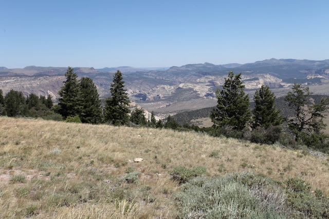
A 26-mile long road takes one from the valley floor to the top of Blue Mountain (actually a plateau). With friends and fellow river runners Howard and Ed in tow, we head up the road to see the canyons and landscapes we will be floating through for the next five days. This view is to the east along a fault-lined valley.
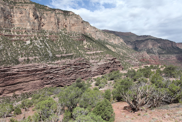
Looking down into the canyon of the Yampa River from the Harper's Corner Road.
On top, we found exposures of the Bishop Conglomerate, a course boulder and cobble deposit that accumulated between 25 and 30 Ma on top of a nearly flat, eroded surface. The conglomerate is extensive in this area but is now only found as remnants on top of plateaus. Note the flat-topped surface in the background - it too has the conglomerate on top. The ancient surface is known as the
Gilbert Peak erosion surface and was a region-wide erosion surface before the cutting of the canyons commenced.
I couldn't resist and hollered tot Howard to stop the car! A herd of cows were wallowing lazily next to a restricted watering hole. The present-day drought does not allow them to venture too far away. I could not help but think of our morning visit to the quarry, where a similar scene played out 149 million years ago, only with large reptiles instead of large mammals. It seems, the more things change, the more they stay the same!
The Canyon of Lodore - To the Confluence of the Yampa River
This is northwest Colorado and it is BIG country with very little population. The Gilbert Peak erosion surface is clearly seen in the distance. The valley is called Browns Park and formed about 20 million years ago when the crest of the Uintah anticline collapsed into a
graben. The Green River likely followed this down-dropped depression east toward the North Platte River and onto the Great Plains before it attained its present course. This is then, an abandoned river valley.
When the Green River abandoned its easterly course through Browns Park, it instead was directed to the south. At the time of the drainage readjustment, the rocks shown in the distance were buried within the Brown's Park Formation. The river at that time had no idea it was being directed on top of a resistant quartzite rock. But as the river whittled away at the Browns Park Formation, it slowly encountered the buried Uintah Mountain Group rocks. It then carved the Gates of Lodore, the site of our river put-in!
After passing the Gates of Lodore, we entered the Canyon of Lodore. The walls were spectacular!
The Uintah Mountain Group is composed of sandstone, quartzite, and minor conglomerate, all fluvial in origin. Detective work reveals that these ancient rivers delivered their load of debris from north to south, during the break-up of the supercontinent
Rodinia. This supercontinent began to fragment about 1,100 Ma. A reconstruction of Rodinia is shown below.
Note the positions of the various continents at this time, with eastern Australia right next to western North America, known as Laurentia for this time period. The Uintah Mountain Group was deposited just above and to the left of the letter "L" in Laurentia. (1.1 Ga means 1.1 Giga-annum or 1.1 billion years ago; belts means mountain chains; craton means an undisturbed continental center).
Running Winnie's Grotto Rapid.
Running the upper part of Disaster Falls, where the John Wesley Powell party lost a boat in 1869.
Lower Disaster Falls.
The Uintah Mountain Group is on average between four and seven
kilometers thick! That's about 24,000 feet. It certainly was a consistently subsiding basin during this time, likely the result of Australia pulling away from Laurentia.
As we progressed downstream, younger rock units descended down toward us. Our river journey was across the southern flank of the east-west trending Uintah upwarp. About midway through the red cliff is the contact with the Lodore Sandstone. This unconformity represents about 600 million years of time where no rocks are preserved. Unconformities are like pages ripped out the center of a book.
The upper part of Hell's Half Mile, a rapid also named by John Wesley Powell.
A stately juniper tree with its roots firmly set in the Uintah Mountain Group.
Although very similar in color, note the difference in bedding characteristics between the lower Uintah Mountain Group (blocky) and the overlying Lodore Sandstone (horizontally bedded). The next day, we would climb to the top of the back side of this cliff for a view upstream on the river.
There were dozens and dozens of Bighorn sheep seen on our trip and this individual was found resting in the sun next to our camp.
Sunset on the limestone cliffs above our camp at Limestone Draw. The upper cliff and intermediate slope are part of the Pennsylvanian age Morgan Formation (about 300 Ma) and the lower, partly shadowed cliff is in the Madison Limestone.
Bioturbation in the Lodore Sandstone looks similar to vertical worm burrows observed in the Tapeats Sandstone farther south. In fact, the Lodore Formation is a dead ringer for the Tapeats Ss. and in fact the two units are correlative, meaning they are the same age and deposited in the same depositional setting.
Note the angle of the beds in this north view, exposing the southern flank of the Uintah upwarp.
We are now almost on the brink of the overlook at the north end of the Limestone Draw campsite.
Voila! The Green River in all of its glory inside the Canyon of Lodore. Note the erosional remnant of Lodore Sandstone making a rectangular cap on top of the underlying Uintah Mountain Group just below and to the right of the photo center. This was an awesome hike!
On the way back someone found a coral fossil, likely eroded from the Madison Limestone above.
Nearing the Mitten Park fault, where beds of the Morgan Formation are upturned against the upthrown side (right). This signals our imminent arrival to Echo Park.
John Wesley Powell named this monolith Echo Rock, composed of Permian age Weber Sandstone. Today it is called Steamboat Rock. Desert tapestries cascade down the rock surface, forming when water drips down from above causing bacteria and lichens grow on the watered surface.
The confluence of the Yampa River, looking east. We were supposed to float the Yampa on this trip but the lack of a winter snowpack made the river unrunnable for our 18-foot rafts. This concludes the first half of the river trip.


