Of all the colorful layers of strata found on the Colorado Plateau, none is as well-known perhaps as the Navajo Sandstone. As one field report described it in exposures found in southeast Utah, the Navajo Sandstone "...usually crops out in a wide belt of rounded cliffs and picturesque domes." So many nature preserves in the Southwest were designated because of the tendency of this sandstone to erode into beautiful and wondrous shapes. Zion National Park comes to mind, as well as Capitol Reef, Canyonlands, Grand Staircase-Escalante, and more.
In December, I joined two friends who also love to explore this exposures in this layer of rock. We were in a little known part of the Navajo Indian Reservation.
We began our hike climbing through other layers of rock on our way to the Navajo Sandstone, barely seen in the background at the top of the photo. Here the claystones of the Chinle Formation (right) are overlain by the Moenave and Kayenta formations. All three are fluvial deposits from between 215 and 200 Ma (million years ago).
In the lowermost Moenave Formation, we observed some root casts, that radiate out from a likely trunk of a small tree. The casts are composed of limestone which replaced the organic matter in the roots.
As we climbed higher, we obtained a great view to the north and saw that all of the strata were tilted down to the east along a monocline. These features formed on the Colorado Plateau during the Laramide orogeny or mountain building event (the same event that caused the initial uplift of the modern Rockies and the partial uplift of the Colorado Plateau). As the shallow-dipping, eastward-moving Farallon plate tugged on the bottom of the crust here, friction between the two caused these kinks in the strata. It's important to remember that when the tilting was ongoing, the rocks shown here were still buried under about one to on-an-a-half miles of overlying rocks that are now eroded.
Once the top of the cliff was achieved, we could see the dipping of the strata dying out to the east.
In the far distance was the profile of eastern Grand Canyon with the South Rim seen as the flat plateau on the left and the North Rim on the right.
Scott and Tony begin heading into the outcrops.
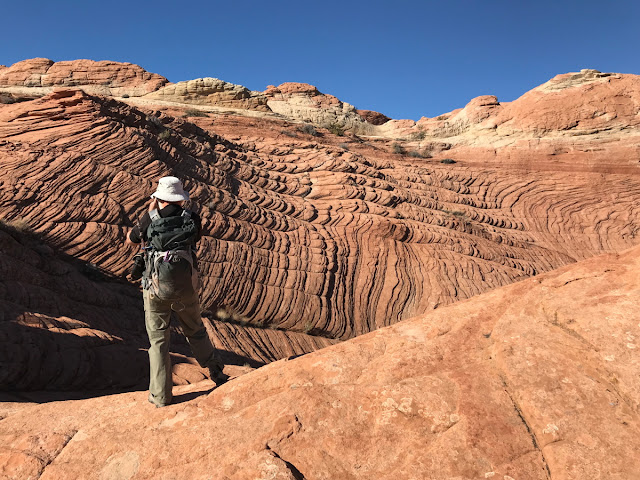
Finally, we arrived on some outcrops of the Navajo Sandstone. This rock unit is interpreted as being deposited in giant sand dunes that were shaped by the wind. The cross-bedding here shows that the dunes were migrating (in this view) from left to right.
Once the sand grains have been lithified into rock and eroded, they take on fantastic shapes.
Note that the cross-bedding does not "disappear" upon becoming lithified - the original texture of the dune is preserved, although it may become a bit compacted. Loose sand has a maximum angle of reps of about 33 degrees but the maximum angle typically found in lithified sandstone is between 25 to 29 degrees due to compaction.
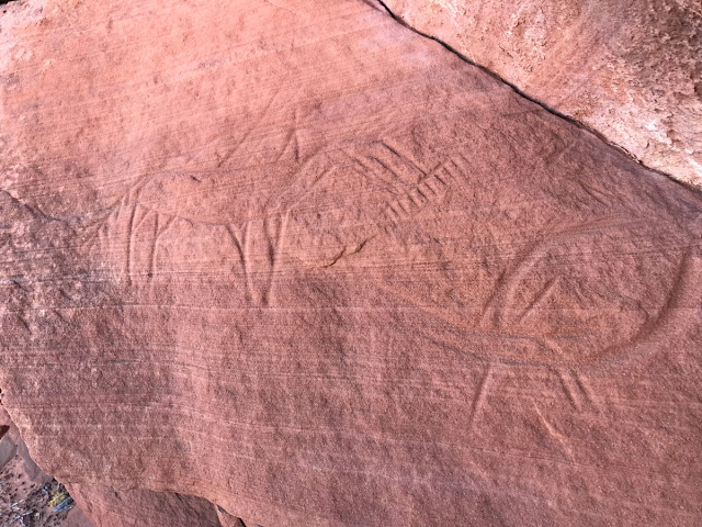
In an overhang, we encountered a crude petroglyph of a Navajo horseman.
Note how each distinct set of cross-beds are all oriented in the same direction. This documents the regional wind pattern at the time of deposition - about 190 Ma. Today this direction is south or southeast but in the Early Jurassic, it might have been a bit different since the North American continent was slightly askew from its present position.
As we ventured farther "inland" the shapes became more pronounced as pinnacles and spires.
Note Tony walking on the cross-beds for scale.
Large water pockets were seen and in the early morning there was a thin sheet of ice on them.
Scott admires a gigantic set of cross-beds.
The small-scale structures within the outcrops reveals many intimate details about the accumulation of sand here. First, note that there are two sets of cross-beds separated by a semi-horizontal line. The cross-beds below are older and were planed off before the second set can in and buried them. The horizontal break is called a bounding surface and may represent the former position of the water table within the dune.
A closer view reveals even more detail. Note the two especially dark wedge-shaped sand beds. These contain larger grain sizes and are interpreted to be where sand avalanched down from the crest. If you've ever played on modern sand dunes, you will recall that avalanching is a common occurrence on sand dunes. Note that the avalanche beds pinch out as they approach the horizontal. For these reasons, these structures are called sand flow toes. The lighter colored beds separating these are where gentle winds deposited finer-grained sand and are called climbing translatent strata. Amazing preservation of detail here!
A much closer look at gravity deposited sand flow toes (dark) and wind deposited climbing translucent strata. Please have a look at this web site with descriptions of eolian terminology and fantastic animations of the processes that create them.
Another fantastic find was the concentration of iron-cemented sandstone clasts in dry water pockets.
Before the Navajo Sandstone was exposed to erosion here, fluids moved through the sandstone and mobilized iron in solutions. Certain chemical environments in these fluids would cause them to place the iron into solution. As the iron-rich fluids flowed elsewhere, a change in the chemistry would cause the iron to fall out of solution to concentrate within discrete beds. Then, upon erosion, the iron-rich sandstone weather into clasts and due to its increased weight cannot migrate too far and become concentrated in these "pools."
More water pockets in the sandstone.
The seasonal light was perfect for accentuating the cross-bedding. In the summer, this would just be flat-looking, without low angle shadows.
"Waves" of cloud crashing across the sky to the south.
"Waves" of cross-bedding crashing within a small gorge.
There was one tricky part getting out of here. One can become "rimrocked" in this kind of terrane very easily. I was glad to had Scott and Tony as my guide in here.
More evidence that we were not the first ones here, although there are very few people who come into this unknown place.
Afternoon light and clouds. What a day! What a place!


