Wednesday, October 21, 2015

Australia and New Zealand Adventure Begins!

Ayers Rock in the Northern Territory, also known as Uluru in the native language
I am off to the Land Down Under and will be blogging from Australia and New Zealand. Be sure to follow me as we explore the Daintree Rainforest, Ayers Rock (Uluru), the great cities of Sydney and Christchurch, as well as Mt. Cook National Park, Milford Sound, Queenstown, and Rotorua, New Zealand. This is a trip with Smithsonian Journeys and the entire itinerary can be found here.
Milford Sound, New Zealand

Saturday, October 17, 2015

New Mexico's Chama River - A Geologic Gem!

Note to the readers of Earthly-Musings:  I apologize for a seeming lack of postings in the last month but I have been busy with trips and numerous weddings. Stay tuned - an Australia and New Zealand adventure with Smithsonian Journeys will begin next week with many postings from down under.

For some, New Mexico may be the one Four Corner state least likely to be associated with the Colorado Plateau. This is not for a lack of colorful sedimentary rocks so much as its lack of famous national parks that might highlight its subtle charms. There is no Grand Canyon or Petrified Forest, no Zion, Bryce, or Canyonlands, and no Black Canyon of the Gunnison, Mesa Verde or Dinosaur National Monument. Only the isolated and southern Carlsbad Caverns come to mind when thinking about parks in New Mexico. But recently, some friends and I explored the officially designated Wild and Scenic Chama River  in northern New Mexico found northwest of Santa Fe. It is a hidden geologic gem!

The river is located just east of the Continental Divide and is tributary to the Rio Grande. The Chama was dammed in the 1930's to regulate its seasonal fluctuations for farmers downstream. I found it curious that one of the dams buttress walls was constructed within the Cretaceous Mancos Shale.

The El Vado reservoir is a high elevation recreation area with water added to the system from the San Juan River on the other side of the divide. A pumping system brings New Mexico their share of their Colorado River allotment. We were floating on San Juan River water but east of the divide.

 Stratigraphic column for the Chama River rocks taken from the BLM guide to the Chama River

After leaving the put-in, the rock strata show an obvious down-dip in the upstream direction. Thus we were getting into older strata as we moved downstream. Here, sandstone in the Morrison Formation  was at the surface.

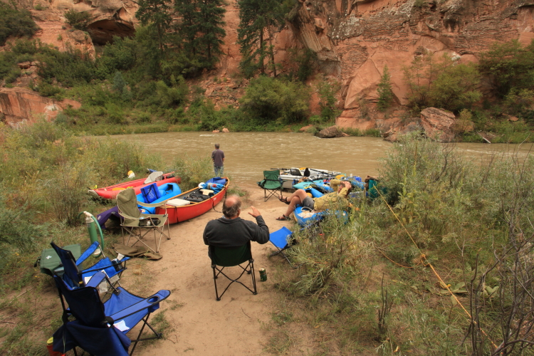
Downstream view of the river from our first camp

None the tarp - we experienced some significant rain on the front end of this river trip but it did nothing to dampen our spirits for the extraordinary scenery we saw and warm comraderie of opur small group of eight.

The BLM  manages the river and has built some very nice sandstone approaches into the campsites. The ranger on duty at the put-in apologized for the "intrusion" into the wilderness but I thought they were well done and did not detract anything from the  experience.

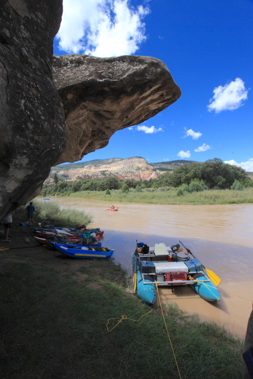
A large boulder of Morrison sandstone attracts kayakers

Fall colors had begun in some box elder trees, even though this trip was over the Labor Day weekend

Beneath the Morrison Formation was the Todilto Formation, a gypsum rich deposit

This unit is commonly seen in northern New Mexico and was deposited along the arid shores of a shallow Jurassic sea.

As the rocks continued to rise up from the river channel, the next unit was the Jurassic Entrada Sandstone, the "star" of the Chama River corridor.

Our second night's camp was across from a beautiful cliff of red sandstone with conifers growing on it. This was great spot to watch the big rain that came later in the afternoon.

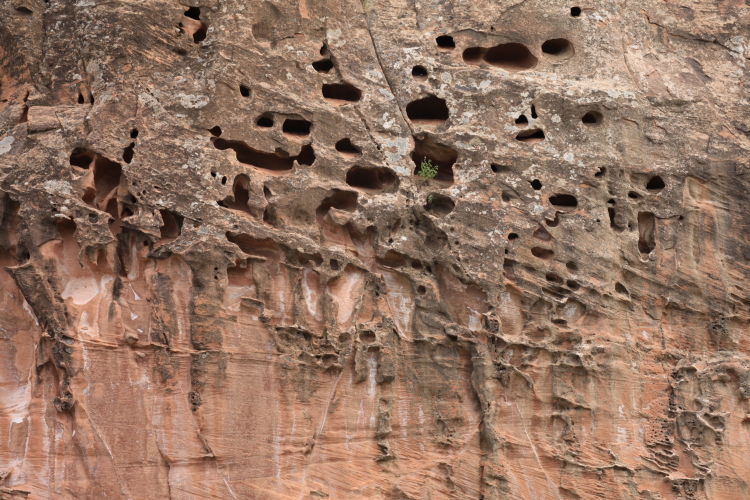
Tafoni in the Entrada Sandstone, fired from case-hardening of the sandstone.

Camp scene on the Chama River. From here we hiked up the cliff behind the camp.

And began to get a great view of the river canyon

One usually doesn't associate a red rock canyon with lush conifers but the Chama is a located in a special place next to higher country that draws in the precip.

What a place!

Telephoto view of the Chama River Canyon

Wide angle view downstream in the Chama River Canyon. The rain began shortly after this photo was taken.

A very foggy third morning greeted us after a night of rain and dampness

John paddles down into the receding cloud cover - the storm had passed

Bill and Don share a quiet moment on the river. Most of the "bigger" rapids on the Chama are located in the final stretch of the river trip. They are really fun Class II and III rapids.

More floating through the Ponderosa pines

The Todilto Formation caps th colorful cliffs of Entrada Sandstone at the southern end of the river canyon. The lower tree-covered slopes are part of the emerging Chinle Formation. In other words, there is no Glen Canyon Group in northwestern New Mexico.

A Benadictine monastery, Christ of the Desert, is located at the southern end of the river canyon and is connected to the outside world by a 15 mile dirt road. Check out the link I have provided to find out more.

Happy boaters! Many times during this three day trip, I reflected on how lucky I am to have such wonderful friends - all who own the proper gear and experience - that places us in such spectacular settings, doing wild and grand adventures!

Our last lunch was beneath an overhang in the Shinarump Member of the Chinle Formation

View upstream from the overhang

Alcove forming at the contact with the Entrada Sandstone and the shale within the Chinle Formation. These alcoves are common where aquifer rocks sit on top of an aquitard or aquiclude. The groundwater (before any canyon cutting) is "ponded" on top of the shale, thus weakening the cement in the overlying sandstone, such that when it is finally exposed, it weathers away faster.

Near the Gallina River coming in from the west

The lowest unit encountered on the trip is the Shinarump Member of the Chinle Formation, a coarse sandstone and pebble conglomerate deposited in a braided stream environment some 225 Ma.

Close-up of the Shinarump cliff near the Big Eddy take-out. This was a fantastic trip in a wonderful area. The Chama River charms and enchants!

Sunday, September 13, 2015

Circum-Ambulation of Meteor Crater at the Northern Arizona University 3rd Annual Geology Alumni Reunion

Educational panel in the Meteor Crater Visitor Center
Studying geology at Northern Arizona University was perhaps the single best thing I did to promote my career as a geologic educator. Located close to the San Francisco Volcanic Field, the Grand Canyon, Oak Creek Canyon, Monument Valley, the Petrified Forest and numerous other world class landscapes, one couldn't help but become enamored with the fascinating story of earth history on display everywhere. The professors were just as enthusiastic about the place and the small class sizes were ideal for learning. NAU however, has been slow in developing a bond with its former geology graduates but that is quickly changing. Paul Umhoeffer, Professor of Geology at NAU since 1992 and current Director of the Environmental Program, is welcoming back past graduates by arranging an annual three day event in September with gatherings and field trips. This year is the the 3rd ever event with a field trip to Meteor Crater located east of Flagstaff.

This trip was led by Tenielle Gaither (BS, 2008; MS 2011) now working for the Astrogeology Division at the USGS in Flagstaff.

Twenty five of us walked the entire perimeter of the impact crater on a hot September day. We had alumni attend from as early as 1972 and as recently as June of this year!

Location map for Meteor Crater 40 miles east of Flagstaff (copied from Tenielle Gaither's field trip guide).

 Gene Shoemaker's 1959 geologic map of Meteor Crater (copied from Tenielle Gaither's field trip guide).

I had never walked the entire perimeter of the crater so this was a special treat for me. I did once hike to the bottom of the crater with my friend Drew Barringer and you can read about that trip here.

The impact is known to have occurred around 50,000 years ago, an age based on post impact erosion rates and two more tightly constrained dates using surface exposure dating techniques.

This is Whale Rock on the eastern rim of the crater where our first stop was made. The sheer size of some of the ejecta clasts was astounding. This rock is about 30 feet tall as shown with more of its mass beneath the nearby rubble.

More ejecta on the southeast rim of the crater

Some of the old works left by Danial Barringer as he searched for the elusive iron meteorite in the pit of the crater. Scientists now know that most of the bolide was vaporized upon impact with perhaps only 20% of it existing as small fragments.

It was a surprise for me to see so much Coconino Sandstone lying as ejecta on the south rim of the crater as it is located in place in the bottom of the crater. Since some of the bottom-most matrial is lying on the south rim, Barringer suspected that the impactor collided with the earth from a northern trajectory. Other studies yield evidence for impact from the southeast or south, suggesting that it likley impacted at a high angle.

Eolian sand on the south rim

Close-up view of the tear fault located on the north rim of the crater. Whether this is a preexisting fault or one initiated by the impact is not yet known.

Dr. Paul Umhoeffer at Meteor Crater during the 3rd Annual NAU Geology Alumni Reunion

Close-up of the ejecta blanket on the southwest wall of Meteor Crater. It is intriguing to think how high this material might have been lifted upon impact.

Photo of overturned beds within the Moenkopi Formation on the south rim of the crater. See the following image for descriptions, however the light orange sandstone in the left center is the overturned equivalent of the light orange sandstone at right center.

Essentially the same view as above but with annotations showing the location of overturned beds in the Moenkopi Formation. These beds were thrown backwards out of the crater area upon impact. All deformations exposed in the crater occurred within about 10 seconds.

Wide angle view of Meteor Crater from the south side looking north.

Cross-section through Meteor Crater showing elevations above sea level, upturned edge of crater rim, and thickness of breccia in the floor of the crater (copied from Tenielle Gaither's field trip guide).

This is the largest fragment of the meteorite ever recovered from Meteor Crater and is called the Holsinger meterorite. The original bolide was about 100 feet in diameter.

Scenic view of the crater from the south rim

Beds of Kaibab Limestone are progressively oversteepened from bottom right to upper center (beneath the people standing on Barringer Point, the highest point on the rim of the crater).

More massive ejecta boulders from the west rim of the crater

This bench mark has the word METEOR stamped in it

Awesome summertime clouds over northern Arizona

Same, same

Stephen Lang was our Meteor Crater Enterprises guide along the trip. He is not formally trained as a geologist but his knowledge of the crater and the processes that created is astounding and was a special highlight on the trip for me. A job well done Stephen! We need more local guides like you in Arizona!
 
My friend and colleague Marvin G. (NAU Geology BS, '79; MS '85) stands in front of one of the historic buildings located on the southwest corner of the crater. Marvin has also been instrumental in making these geology reunions fun and welcoming!

View to the south of the silica pits, where silica was mined

Close-up of a wall in the silica pits exposing two large red clasts from the Moenkopi Formation. Many thanks to the folks at Meteor Crater Enterprises for hosting the 3rd Annual NAU Geology Reunion Field Trip!