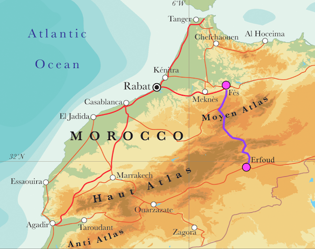
Map of Morocco showing the route from Fes to Erfoud at the edge of the Sahara Desert. The map is labeled in French such that Moyen Atlas stands for the Middle Atlas Mountains and Haut Atlas means High Atlas Mountains. Note that Fes is located in a valley where the Middle Atlas begins.
For about 30 miles, the highway slowly climbs through rich agricultural lands of olives and grapes.
The village of Azrou is located at 4,100 feet in elevation and is constructed in a Swiss chalet style. It attracts snow in the winter and there is a ski area nearby.
Further along is a place where the Barbary Macaque (Macaque silvanus) can be observed at close range.
They are quite playful and I could watch primates for hours and not be bored.
Soon we climbed into the Azrou volcanic field, with basalt volcanoes and flows about 3 million to 600,000 years old.
Basalt and scoria cone.
This was a specular day for clouds and huge thunderstorms had rocked the western Sahara and the Atlas Mountains.
The highway followed this lava flow uphill for about 18 miles. The relative age of the flow can be known by noting the small arroyo cut into the top of the flow. In the distance, limestone bedrock protrudes above the younger flow.
The highway climbed to over 7,000 feet through cedar, oak and pine forests. Large dead trees have been affected by recent years of drought in Morocco. These large trees are Atlas or Atlantic cedars (Cedrus atlantica), closely related to the Lebanon cedar.
It was a bit disheartening to see this logging truck as we whizzed by in the bus. We had heard that the Atlas cedar trees are now protected. Perhaps these lumberjacks are merely cutting the dead trees, which are thought to be dying due to the long-term drought in Morocco. See this article about their current status.
A last look at the majestic Atlas cedar before descending into the Sahara.
Looking back to the west as we climbed out of the Moulouya River valley. Note the giant cumulonimbus clouds forming in the early afternoon over the mountains. Lightning was seen at night within these clouds.
A woman along the highway near Air Ba Lahsene pushes her donkey with its load toward home.
Near Air Ba Lahsene. Note how runoff from above creates evenly spaced rills in the hill slope...
To the south the highly deformed sedimentary rocks were spectacular in the late afternoon sun! I was so jazzed to see this. The view shows the result of uplift during the Cretaceous time period.
More spectacular folding of the strata along the Ziz River (lower part of the photo).
Entering the Ziz River Canyon in this downstream view.
This is an upstream view after entering the canyon. The rocks are Jurassic age limestone. This scenery really floated my boat!
The canyon reminded me very much of the San Juan River canyon in Utah, although this particular one was a bit wider and not as deep.
Exiting the canyon near Errichidia, I noticed a bed of hummocky limestone in the cliff.
Overturned beds in the limestone near Errichidia. Merely driving by, it was hard to determine which limb was right-side-up and which was overturned.
Beautiful sky at the Hassan Ak-Dakhil reservoir on the Ziz River near Errichidia.
The Ziz oasis below Errichidia. The majority of greenery in the valley bottom are date palms and olive trees.
Sunset from the Ziz oasis. What a drive we enjoyed! Spectacular views and great weather. The rains had cleared the skies. Next up - the Sahara.


That was great, Wayne. Made me think of the San Juan too, particularly the approach to Mexican Hat.
ReplyDelete