Sorry for the delay folks! The end of the trip was a blur with no time to write. But I will be posting from home about our last few stops - Torres del Paine National Park Chile, La Paz Bolivia and Lake Titicaca Peru.
After leaving Buenos Aires, we flew down over the Pampas (the Great Plains of Argentina) and across the eastern side of Patagonia. We landed in Punta Arenas but did not go into the city proper. Instead, we drove 3 hours east and north through the Patagonian landscape to Puerto Natales.
We often board our private jet using stairways out on the tarmac. This gives us an opportunity to be greeted by our captain, Peter Wittik whom I have flown with before on an Around the World trip in 2013. Our jet is fabulous!
Here I am with my fellow lecturer, Hugh Neighbor. Hugh is a former employee of the US State Department with assignments in Fiji, Bolivia, and Austria. We give our lectures in the space just in front of our seats. It's a neat system - our lectures are broadcast over Wi-Fi onboard and the passengers see the slides on iPads and hear our voices over Bose headphones.
Lifting off out of Buenos Aires. The sun finally came out. We had two days of rain prior.
The Straits of Magellan in the southernmost part of South America.
On the way to Puerto Natales, we had lunch at a Patagonian estancia (ranch).
They raise llamas and sheep here and a gaucho was rounding up a herd of llamas. I include a few scenics of this.
Llamas on the Patagonian landscape.
Near the corral.
A young, curious llama.
The following day we were on our way to the national park out of Puerto Natales. You can see the lines in the snow that denote sedimentary rocks in the landscape. These are mostly Cretaceous shales, sandstones, and conglomerate.
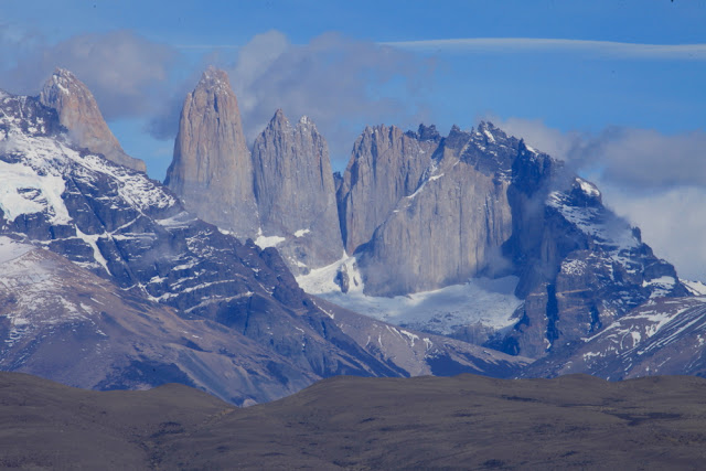
We entered the park from the east side and got our first view of the Paine massif in the distance. There is often overcast, rainy weather here so I was so pleased to see that we would have a nice day.
As we neared the park the details of the rocks became obvious. These are the Cuernos de Paine (cuernos = horns; paine = blue and pronounced pie-nay). More on these later but note the black caps on top of light-colored granite.
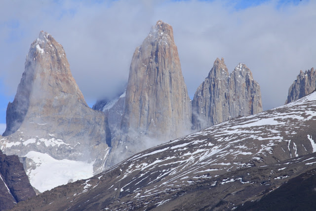
These are the Torres del Paine (torres = towers). I hiked up to the base of the towers in 1993 on a seven-day backpack and would love to do that again.
A wide view of the Patagonian sky! The east side of the park is by far the sunniest as the massif creates a massive rain shadow.
Reflections on Lago Amarga (Bitter Lake).
The granite is a mere 12 million years old and has cooled, crystallized and been brought to the surface and eroded in that short amount of time. It likely was not emplaced too deeply - perhaps only 2 to 2.5 miles down.
To the south (the part of the park that no one except crazy geologists look towards since the Towers and Cuernos are to the north) are black shales of the Cerro Toro Formation. These rocks were laid down in the Cretaceous Magallanes basin ∼100 Ma, which was then located in the South Atlantic Ocean. The shales were laid down in about 6,000 feet of water, explaining their fine-grained nature.
However, within the shale are these very coarse conglomerates - an odd relationship. How could these well-rounded cobbles and bounders become interbedded with fine-grained, deep-water shale? The answer is seismicity! In the Cretaceous, the early Andes Mountains were being uplifted and shading coarse sediment to the east to the coastal margin of the Magallanes basin. When earthquakes related to the tectonic setting mobilized the nearshore gravel and cobbles, they became entrained in submarine debris flows called turbidites. Amazing preservation of a tectonically active margin.
A Nineo plant (Anarthrophyllum desideratum) frames a beautiful view of Lago Nordenskiold and the Cuernos del Paine. The bright red flowers are a sure sign of spring in Patagonia.
So what about these variably colored rocks in the Cuernos and Towers? The black caps are the shales of the Cerro Toro Formation and the light-colored granite intruded into it about 12 Ma, forming a laccolith (lacco = Gr. for cistern or chamber). A laccolith is a mushroom shaped intrusion. This laccolith is highly dissected giving the interesting distribution of rock type and color. Glaciers carved the deep valleys on the flanks of the massif.
This is the highest peak in the Paine massif, Cerro Paine Grande (Big Paine Peak) at 9,462 feet. It is capped with the black shale turbidite.
A final view of the Cuernos del Paine as we head back to Puerto Natales.


Love love love these photos. We lucked out, as you did, to have beautiful weather when we were there. We hiked almost all of the "W". Such memories! Joe and I read your blog and are constantly amazed at your life. I wonder how many countries you have been to?
ReplyDeleteJudy
Wow! Great photos and descriptions! Can't wait...thanks Wayne.
ReplyDeleteThanks for sharing a nice post. These pictures are obviously amazing. Really Torres Del Paine is a gorgeous place. The famous W Trek in Torres Del Paine is the perfect destination for the adventurous traveller. The park is becoming a very popular hiking destination, and accommodations fill up fast. This park is the most visited hiking area in all of Patagonia, and hoards of trekkers come here each season to experience the unbelievable natural beauty of this park. We just hiked the W trek a few months ago with ChileTour Patagonia and had such a great time! Really this place is so beautiful and attractive that was beyond my expectation. It was an amazing trip for us and we enjoyed a lot.
ReplyDelete