I recently returned from a 10-day trip to Canyonlands National Park, which included a 7-day river trip on the Green and Colorado Rivers. It was beyond fantastic. We had a great group of folks who were really interested in geology and natural history. The river portion of our trip was outfitted by Colorado River and Trails Expeditions (CRATE) and their guides gave us a superb look at the landscape. The 4X4 land excursion was run by Navtec of Moab, Utah. I took over 950 photographs, so the postings will come in various parts. Thanks for reading.
The La Sal Mountains laccolith rise above the Canyonlands region near Moab, Utah. Here rocks in the Cutler Group are exposed in the Colorado River canyon between Moab and the rivers junction with the Green River.
The White Rim Sandstone caps the Organ Rock Formation near Musselman Arch in Canyonlands National Park
The Colorado River as seen from along the Shafer Trail. Our journey overland gave us a great introduction to the scenery we would be seeing.
On day 3 we boarded planes for a scenic flight into the river put-in at Mineral Bottom. This is a new Kodiak aircraft operated by Red Tail Aviation, which was quiet and comfortable.
It was a short 20-minute flight. Here we are beginning our descent into Hell Roaring Canyon.
Touch down at Mineral Bottom. The dirt strip was fine and there was plenty of room to land and take off.
On the river! This part of the Green River is known as Stillwater Canyon and it is well named.
Looking up a side canyon four miles to Upheaval Dome. We had visited this meteorite impact structure on our land excursion and new could see it from the bottom up. Later on, during the scenic flight out from the end of the river trip, we would see it again from above!
We took a hike at Fort Bottom to an Anasazi site located on a bend in the river. Along the way I spotted some bone fragments within a sandstone from the Moenkopi Formation. These are likely skull fragments of an ancient amphibian known as a metoposaur. These large bodied creatures roamed along the shores of Triassic rivers in North America.
The view of the "gooseneck" in the Green River from the Anasazi site at Fort Bottom
The Fort of Fort Bottom
A bend in the Green River downstream of Fort Bottom
Along the Green River exposures (from top to bottom) reveal small ledges of the
Kayneta Formation on the far mesa top; sheer cliffs of Wingate
Sandstone; multi-colored slopes and small cliffs of the Chinle Formation;
and yellowish to red cliffs and slopes of the Moenkopi Formation nearer to the river. Within the Chinle Formation are five members. From the base of the Wingate cliff they are the Church Rock (red slope), Black Ledge (top dark cliff), Owl Rock and Petrified Forest members (greyish slope), and the basal Moss Back cliff. The fort we visited is built upon the Moss Back Member.
An old cabin still stands on the bar at Fort Bottom
Spectacular scenery along the Green River. In the foreground, the White Rim Sandstone is emerging from beneath the river channel. As we floated downstream, the layers rose up to expose older and older layers of sedimentary rock.
The Buttes of the Cross, named by members of the John Wesley Powell Expedition in 1869. The stratigraphy explained earlier is well exposed here.
The contact of the overlying White Rim Sandstone with the organ Rock Formation produces springs along the river. Groundwater that resides in the sandstone is forced out horizontally when it encounters shale in the Organ Rock. The White Rim Ss. is an aquifer and the Organ Rock acts as a aquatard.
Numerous small Anasazi ruins can be seen along the river corridor
Note the isolated erosional remnant in the center of the photo known as the Turk's Head. It is formed within a bend in the Green River.
Here is the same feature but seen in another view obtained as we floated by. We pulled over and did a short hike here.
There were more ruins to be seen here. The ruins are all very small here suggesting perhaps that this was the fringe of Anasazi culture.
View from the base of the Turk's Head toward the viewpoint on the rim at Island in the Sky
A dead kit fox makes a menacing face
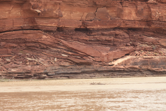
Numerous channel features were observed in the Organ Rock Formation as we floated by. These features were cut into preexisting sediment, then infilled with other mud, sand, or silt.
To be continued.....


Is that Janet holding that fox?
ReplyDelete