Monday, August 07, 2023

Not Able to Comment

Some readers have expressed frustration at not being able to comment on this blog. The problem has been going on for years. I may have found out why. See this:

Many people disable third-party cookies on their browsers, and that is the usual cause of the problem. Because of the nature of the internet, this is a choice that users make in their browser settings.

I wish it were not so - I often disable cookies on my browser as well. Until we can find a solution to the pervasive problem of "Money is answer to everything" (meaning that cookies enable "free" internet sites to track your interests), I cannot think of a solution except to enable cookies for the time it takes to comment. Maybe that will work.

Please know that I appreciate my readers, the personal comments you send to me about enjoying the blog, and that I share the frustrations this causes.

More posts to come! WR

Sunday, August 06, 2023

Trekking the Dolomite Mountains - Days 1 and 2

The mountain region visited between Munich and Venice

Let the trek begin! We had six very nice days ahead of the trek in Munich, Innsbruck, and Monguelfo/Welsberg in the South Tyrol of northeast Italy. The Dolomites aare located at the eastern end of the Alps.

Overland route and modes of travel to the trailhead

We took many forms of transport to get to the trailhead - double-decker bus, trains, and finally a private transport van from Monguelfo to the trailhead near Cortina d'Ampezzo. 
Before we begin a description of the trek, I include two last looks at the area near Monguelfo.

In the Val de Santa Maddalena northeast of Monguelfo - this is Bavarian!

We took public transport to a secondary valley called Santa Maddalena. Lots of milk cows graze these pastures and dairy farming is dominant here.

The mountains in the Val de Santa Maddalena are not the Dolomites limestone 

The crest of the mountains in the background forms the international boundary with Austria - since 1918. Italy entered World War I with the express purpose of taking territory from the Austro-Hungarian Empire. And they partially succeeded during negotiations at the end of the Allied victory. However, it was not all that they had hoped for and the bitter aftertaste left over from the agreements fertilized sentiment that eventually brought Benito Mussolini to power in the 1920s. The Dolomites are rich in ruins of World War I fortifications and an interesting story about Italy's involvement in The Great War can be found here.

Day 1 - June 21
 
Don, Anne and Helen at the trailhead near Cortina's D'Ampezzo

Finally, we began our trek on June 21 at Sant Umberto at an elevation of 4,900 feet. This is the entrance to the Natural Park of the Ampezzo created in 1990. However, this area is also part of the Regole d'Ampezzo, a collective form of ownership of the pastures and forests in these mountains. The first documentation of the regola here goes back to at least the year 1225! You can read more about this interesting European institution here and here. Learn about the management of this collective heritage here. All of this is information I found only after our trek and in composing the blog. So interesting!

Google Earth image of the first two days of trekking. Refugios in orange.

The annotated Google Earth image above shows our trailhead located just north of Cortina d'Ampezzo. I'll post a Google Earth image for each segment of the hike and the above shows the route for days 1 and 2. We began in a forest, entered a meadow at Ra Stua, then climbed up switchbacks on a dirt road to the plateau where our first Refugio, Fodara Vedla is located. The total distance on day 1 was about 5.5 miles and on day 2 was about the same (although the 2nd day felt more like 8 miles!).

A view to the north of the Dolomites from near Ra Stua

Throughout the hike, I noticed a gentle but persistent northeast dip to the rocks (down to the right in this view). Localized faulting and folding occasionally would interrupt this pervasive dip but it was observed on numerous days in the mountains. When I took this photo, about an hour into the nine-day trek, I could not know how prevalent the dip would be - only as the days rolled on did it become apparent to me.

Looking south as Helen crosses a bridge

We had purchased a self-guided tour package that included 12 nights lodging, transportation to and from the trek, and a detailed itinerary to get us where we needed to go. The directions could have been a lot clearer on this first day - or were we just in need of getting used to the vagaries of European mountain travel? They measure distance in time. Still, not all of the signposts or junctions we encountered were mentioned in our notes for this stretch of trail.

We eventually made it to our first lunchtime refugio, Ra Stua

About 1.5 hours on we enjoyed a cappuccino and some delicious French potatoes at Ra Stua. Hey, this is pretty civilized hiking and quite nice!

Figuring it out at Ra Stua

Like a lot places around the world, the people in charge of making signs or describing routes may not travel themselves and since they are intimately familiar with their home, they don't always explain things that can be readily understood by visitors. It took us a few days to sense and feel what the locals have known for centuries. Travel is fatal to prejudice - Mark Twain.
 
On the "trail" after Ra Stua

It was a bit surprising to learn that "the trail" actually included many roads, a few of them even paved. In fact, it wasn't "a trail" - it was many trails and with different numbers that are all patched together to form what they call the AV 1 or the Alta Via 1. It did make for nice hiking.

Climbing up from Ra Stua

Just past Ra Stua we left the valley and began a climb up to a plateau to the west (about a 750 ascent). I had bought a pair of new hiking pants with really deep pockets before the trip and kept pulling out a bandana to wipe the sweat off of my forehead. When we got to this place above, I reached into my pocket and the bandana wasn't there. So Helen (dressed in the yellow shirt above) offered to go back down the switchbacks to get it. What a sweetheart! She went down four or five switchbacks and came back without it. Turns out that the pockets on the pants are REALLY deep and the bandana was hiding deep down. My bad. But it gave me a chance to check out the Triassic limestone that would be our beacon for the next nine days.

On the plateau and looking south to Sas dla Para (upper left) - it is shown on the last
Google Earth image - the one with the trails on it

We had climbed 750 feet to an open plateau. Along the ay we saw two marmots, the only two I would see the whole trip. The mountains lay before us!

Refugio Fodara Vedla

At last, through a hazy sky, we arrived at Fodara Vedla, elevation 6562 feet. I had chosen these specific dates in an attempt to "beat" the seemingly eternal haze that seems to settle over Europe in the summer. It looked like I might have failed in the attempt, at least on this day.

Note the reflection in the window too

The sign says it all - the is no connectivity here in the mountains but somehow we were able to connect! The occasional cell signal did migrate to many of the refugios.

Fodara Vedla dining room

Every refugio we experienced was like a small, rustic hotel complete with running water, kitchens, full bars, beds, just about everything. And this is how day 1 ended. We had one of our best Primi Piatti's here (First Plate) - an eggplant ragu -lovely!

Day 2 - June 22

A last look at Fodara Vedla and Sas dla Para (photo by H. Ranney)

The day began with a descent that was so steep we all commented about it. It was about 1400 feet and mostly on a paved road (to resupply Fodara Vedla). But it was only paved because vehicles would not be able to gain traction were it dirt. Our legs ached at the base of the hill.

Down, down, down

On sections that were not as steep, the road reverted to dirt. But on the curves and the steep stretches - wow! You really had to watch your footing. The worst part - our next refugio was located at the same elevation as the last and we would have to make the climb back up on the other side. Note the same northeast dip to the rocks ahead. Many caves could be seen in the bedding planes of the strata.

Refugio Pederú in the Val de Tamersc

You can see the Refugio Pederú in the valley floor but note the debris flow coming off the mountain. Everywhere we went we saw evidence for recent events that had sent huge volumes of rock down these steep walls. It was impressive and I took many photos of them.

Art installation on the valley floor at Pederú

Cappuchino Italiano!

Helen doesn't normally drink coffee but the lure of a mid-morning cappuccino in Italy was too great a barrier! They were delicious.

The road to Refugio Lavarella

After leaving Pederú

A steep climb was made on a trail to the west of the road (both visible with the trail on the left and the road on the right in this view north back toward Pederú). Mountain and power bikes took the road and hikers took the trail.


It seemed to go on longer than it should have or actually did. But the scenery was grand!

Sign to Refugio Lavarella

Mandatory shoe racks in the refugios

All of the refugios have shoe racks located in the basement of behind the bar. Upon entering one removes their hiking shoes and takes them to the shoe rack. This one at Refugio Lavarella has heated posts to dry out the boots (it often rains and there can be wet shoes).

Refugio Lavarella

You may have noticed on the sign two photos up an advert for beer. Lavarella has its own brewery and they announced it as the highest brewery in Europe. The beer was very tasty.

Sunset from Lavarella

Thus finished our first two days. I'll be posting more soon Thanks for reading.

Sunday, July 30, 2023

Long Time Dream Fulfilled - Trekking Italy's Dolomite Mountains

Sometime in the late 1970s, while studying geology at Northern Arizona University, I came across some photos of the Dolomite Mountains in Italy. To say they were spectacular in those few photos would not convey adequately the way they touched me deeply. I vowed to go there one day. Then a few months after I met Helen Thompson in 2005, she casually asked me if there was any place I had not yet been that I would like to one day go. The "wheels" in that imaginary slot machine spun around in my head for a few moments, bypassing Milford Sound in New Zealand, Perth, Australia, and the Karoo in South Africa, until it finally settled on... the Dolomites. So I blurted out to her. "The Dolomite Mountains in Italy!" She never forgot that and 18 years later she made that dream come true for me.

This will probably take a few posts to capture the length and breadth of our trip. It was amazing in every way, scenically, physically, geologically, culturally, and culinarily. I'll try to embed the flavor of each of these somehow in this and subsequent posts. 

The location of the Dolomite Mountains in northeast Italy

But first, what about that initial photo from the late 70s? It must have been in some geology textbook, showing the clearly deformed nature of the sedimentary rocks in the Italian Alps. (BTW, I had never seen nor visited the Alps before, a huge "hole" in my geologic résumé). In 1985, I purchased a used copy of a book called, "The Dolomites," by C. Douglas Milner, published in Great Britain in 1951. He was a climber and by then numerous Brits were making their way to the Dolomiti. It seems I was still on the trail of these (to me) elusive mountains.

An image from Milner's book. Scenes like this inspired me to one day visit the Dolomites.


Our trip would include a nine-day trek over 85 miles in length through rugged mountains on what turned out to be poorly maintained trails (my personal post-hike assessment). But travel that far requires extra time to accommodate to the changes in time zones, insurance against delayed (or lost) gear, and to visit other desirable nearby places. So we flew in and out of Munich Germany with additional visits to Innsbruck Austria and Bolzano Italy.

Marienplatz in Munich's city center

We arrived into Munich on time in the early afternoon, checked into our hotel and adjusted to the time zone by staying awake until it was bedtime in Munich. We were well situated to the city center and walked to the Marienplatz (translation: Mary's Plaza). The Old World style of building always fascinates us Americans. As does World War II history and Munich has much of that (although we did not partake of much of that - except a very interesting and highly reflective visit to Dachau, the first of the concentration camps).


The Seigestor Gate on Munich's north side, commissioned by King Ludwig I in 1852

We enjoyed Munich very much. There was a lot of history and Helen got to revisit the famous Hofbrauhaus from a childhood visit in 1970. We spent two night here and enjoyed it. But it was time to head south as we had not yet seen any mountains. That would soon change.

On the road southwest toward Garmisch-Partenkirchen, Germany

We booked a Flix public transport on a double-decker bus. I did this in advance of the trip and saw that you could reserve specific seats. So I booked the very front two seats on the upper deck with a large windshield, so that we could look out and watch the landscape unfurl. About an hour out of Munich we captured our first glimpse of the Alps. One in Garmisch-Partenkirchen the officials came onboard and seriously checked out the passports of everyone on the coach - the driver was incensed that now he would be late getting in to Innsbruck. 

The Inn River in Zurl, Austria

We crossed the divide between Germany and Austria and soon the road descended steeply into the valley of the Inn River. It was spectacular. The river begins farther west in Switzerland and flows east toward the Danube. There is a very obvious terrace that was apparent everywhere in the Inn Valley and a quick internet search suggested that it may be Pleistocene in age. The terrace is visible in the photo above. 10,000 years of downcutting by the Inn River may have formed the geomorphology here.

A pedestrian bridge in Innsbruck's city center

We loved walking the old city center in Innsbruck (The name means "Inn River bridge"). We walked everywhere, including the old tower, climbing 159 steps for a great view of the city. The public transport is easy and cheap. In fact, most hotels in the Tyrolian Alps will give guests a card to use public transport for free! I participated in a guest survey while in Innsbruck that asked how it would be paid for (they don't have it yet here). But while in Italy, our hotel hosts freely gave us these cards. They even include rides on the mountain gondola's - considered public transport. All very civilized, modern, and sensible. One other aspect I noticed on this trip - many dates given for the founding of these cities were about the mid-12th century. Munich, Innsbruck, Bolzano - they all seemed to have been established about that time. Makes me wonder if the Medieval Warm Period may have facilitated an expansion of humanity around that time? And interesting thought.

Colorful buildings along the north bank of the Inn River in Innsbruck

The city had 60% of its building damaged in World War II and those in the photo above look like newer construction. You can read a bit more about the bombing of Innsbruck here. Sad to think about as the vibe today is completely different - gelato shops everywhere! We were still just getting our bearing on being in such a foreign land so we did not venture too far from the city center and there was plenty to see here. But the gondola looks like a nice destination for the next trip.

Arizona meets Austria

We ran into our dear friend Bil while in Innsbruck. His wife is of German descent and she comes to Germany often to visit family. It was a quick trip for him on the train from Garmisch-Partenkirchen to Innsbruck.

View of the Dolomite Mountains from Monguelfo, Italy

Finally, we caught a train from Innsbruck to Italy and the staging area for our trek, Monguelfo. Northeast Italy used to be part of Austria until the end of World War I, when Italy took over some parts of that territory. You can read more about this interesting history here. Therefore, all towns in this area have two names, a German name and an Italian name. Monguelfo is Italian but it is also called Welsberg. It is a quaint and friendly town. We loved it and our hotel hosts were so kind to us.

Now the hard part would begin - a nine day trek through the mountains. But the rewards were great and well worth the sweat equity!

Tuesday, June 13, 2023

The 4th NAU Geology Alumni River Trip in Grand Canyon

In May of this year, 19 alumni of the Geology Program at Northern Arizona University gathered in Flagstaff for the 4th-ever alumni river trip in Grand Canyon. What a wonderful time traveling with old and new friends. Many of the participants this time were from my era at NAU. Some were from the 2000s and we had three from the 1970s. NAU Geology Rocks!

Dr. Jim Gaherty of NAU was along as faculty along with his wife Dr. Donna Shillington. Here Jim is talking near Sunset Crater and the San Francisco Peaks about the migration of volcanism in the region.

Two dear friends from NAU Geology in the 1980s - Ralph Hopkins (center) and Mike Darr (right). We are at the Desert View Watchtower on the pre-river trip field trip.

At Lees Ferry getting ready to depart.

Reptile trackway in the Coconino Sandstone. Avalanche features are also present on this surface.

Vasey's Paradise is back after a bountiful snowpack on the Kaibab Plateau this past winter. This voluminous spring was virtually dry the last few years due to a lack of precipitation.

The "hump" of limestone seen in the photo center is a mud mound within the Redwall Limestone. Algae likely was growing here on the seafloor some 340 million years ago, trapping silt and clay size particles.

Rafting past Grey Castle carved into the Bright Angel Shale in Marble Canyon.

Garnets found in the Vishnu Schist give an indication at what temperatures and pressures the schist was metamorphosed from shale or sandstone. This species of garnet forms at temperatures and pressures that today, are about 10-15 miles below the surface. Incredible to think that these rocks, now returned back to the surface, were once buried in that amount of crust! Where did it all go? Not to outer space - it was eroded onto the ancient landscape somewhere. But so much time has passed, who knows where it is now.

A typical camp scene - this one at the lower Garnet Camp near river mile 114. The Powell Plateau is on the top left skyline.

The oldest rock in the canyon is the Elves Chasm Gneiss, dated at 1.84 billion years old. This makes it 90 million years older than the Vishnu Schist.

I am enamored with cavitation pits that form on limestone near the rivers' edge. As fast moving river water encounters a tiny protrusion on an otherwise smooth boulder surface, it hydraulically forces the water away from the rock surface, creating a vacuum between water and rock. When the vacuum collapses, the concussive force pops off a piece of the boulder creating the scalloped pits.

I can never say it again - no one ever photographs this site - and landslide composed entirely of limestone debris. Fellow river runner Jon Hirsch was the first person to notice and describe this landslide.

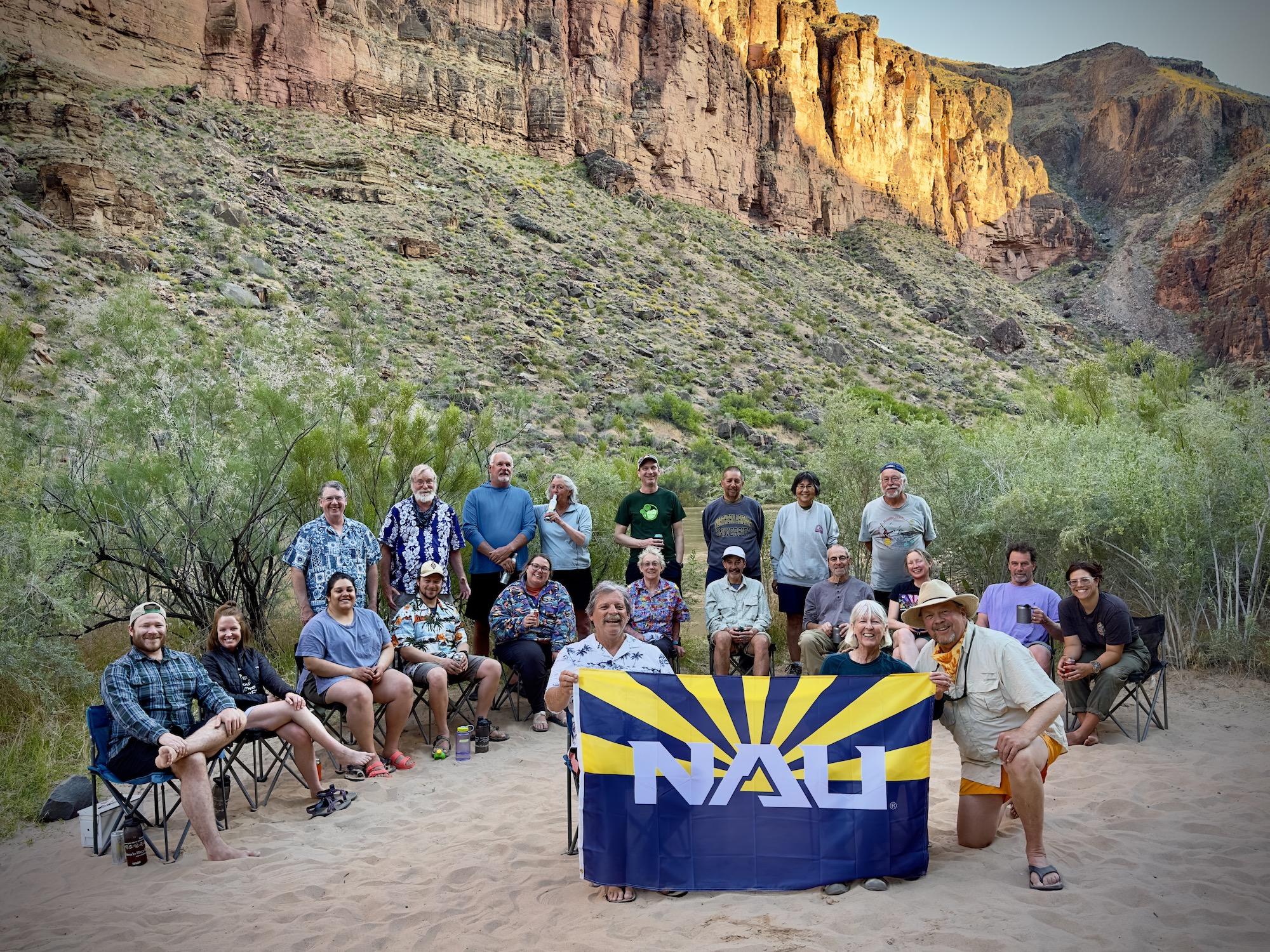
Our group - what a wonderful trip. So many memories and new ones made on the river in Grand Canyon!