Too cool for words to see this in public media. Read the article here.
 |
| Evidence of rivers on Mars (left) the Nile (center) and on Titan. |
Too cool for words to see this in public media. Read the article here.
|
| Evidence of rivers on Mars (left) the Nile (center) and on Titan. |
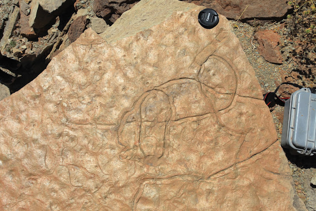
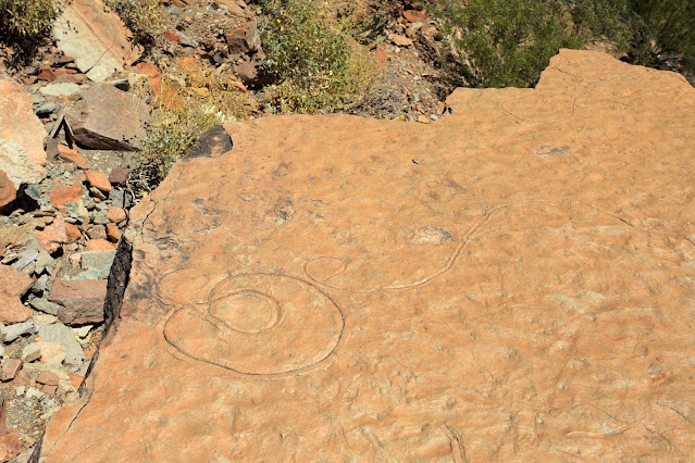
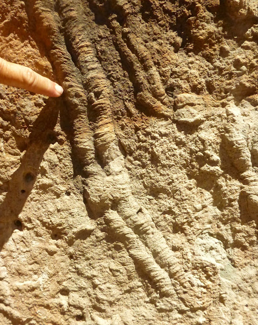
The Grand Canyon is nearly 280 miles (450 km) long! And no less than 26 named rock units are exposed in its walls. John Wesley Powell, in seeking funding for his river trip survey in the 1860s wrote to Congress saying, "the Grand Cañon of the Colorado will give the best geological section on the continent."
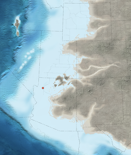 |
| Paleogeographic map of the southwest USA 505 Ma when the Bright Angel Shale was deposited. The red dot denotes the location of the fossil in this posting. Map courtesy of Ron Blakey and DeepTime Maps. |


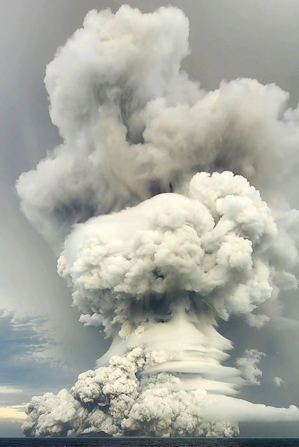
It's all over the news and there is good reason. At 16:28 local time in Tonga on January 15, a powerful submarine volcanic eruption rattled the area. Satellite photos are astounding. The noise from the explosion was heard as far away as Aukland New Zealand (1300 miles away) and tsunami warnings are posted for much of the Pacific Rim.
Check out this link from Forbes and all of the embedded links. They are pretty astounding.
If you follow Twitter here is a video of the tsunami coming ashore in Tonga. (We have a neighbor who has done anthropologic research on the island and the proper pronunciation is Tong- ah).
Thanks to the folks at the Arizona Geological Survey for this first hand description of the geology of the volcano and published first of The Conversation. The maps are very instructive.
Geology Hub is another good resource to check out. Watch the whole video as the last half of it has the geologic story of this caldera. Note that some of the photos to illustrate a tsunami are not from this event and may not be of tsunami waves at all. A tsunami wave typically moves 500 miles per hour when in the open ocean and may only be six inches high. But as the wave approaches land and the water shallows, the wave height increases.
Great videos can be watched here.
We hope all will be all right and all will be safe from this.
UPDATE ***My colleague George Marsik, forwarded this pre-eruption view of Hunga-Tonga volcano using Microsoft Flight Simulator. There are some great views of what this volcano used to look like before January 15.***
2nd UPDATE: Please see Roseanne Chambers geology blog as well for a great description of the eruption and tsunami: https://roseannechambers.com/tsunami-troubles/.
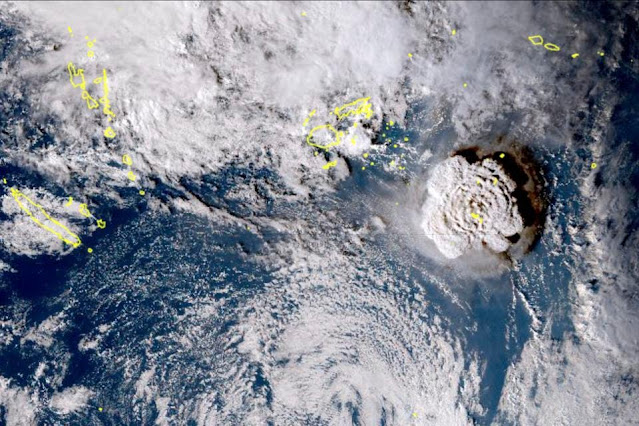 |
| This satellite image taken by Himawari-8, a Japanese weather satellite, and released by the agency, |


This from Michael Conway at the Arizona Geological Survey.
 |
| Photo: Hunter’s Point, south of Window Rock, displaying a beautiful expression of the East Defiance monocline, a Laramide fold. The rocks are mostly sandstones of Pennsylvanian through Triassic in age. Photograph by Stephen J.Reynolds |
Arizona Geological Society presents
Roadside Geology of Arizona
Stephen J Reynolds and Julia K Johnson
School of Earth and Space Exploration
Arizona State University
Tuesday, 7 Dec. 6:30 p.m. (MST)
ZOOM (https://arizona.zoom.us/j/87908544524)
Passcode: AGS-2021
ZOOM Venue open at 6:15 p.m.
ABSTRACT. Arizona is an amazing showcase of geologic features and processes. The landscapes of the state reveal a fascinating geologic story, and most chapters of this history can be observed by traveling Arizona’snetwork of federal, state, and local highways. With some strategies for observing landscapes and a general understanding of the of and events,a traveler can piece together the main plot lines of the history. We are using this observe-first, stratigraphy-first approach to write a new version of Roadside Geology of Arizona. In this talk, we will employ a regional approach to Arizona as we explore the geologic scenery of different parts of the state, highlighting the stratigraphy, structural styles, key geologic events, andnotable scenic landmarks.
Presenters
Dr. Steven J. Reynolds was recently named ‘President’s Professor’ at ASU. He has au thored or edited more than 200 geologic maps, articles, and reports, including the 866-page “Geologic Evolution of Arizona. Steve is a past president of the Arizona Geological Society.
Ms. Julia K. Johnson is a geologist and geoscience-education researcher. Her geologic research focuses on the geologyof Arizona, and her education research involves the use of concept sketches in geoscience learning and teaching. She is a co-author of one of the Arizona Geological Survey’s most popular contributed maps: “Geologic Map of thePhoenix Mountains, Central Arizona” (~60,000 views).

 |
| Aerial view of the confluence of the Green (light brown) and the Grand (darker brown) that formed the Colorado River (left) prior to 1922 . (Image taken May 25, 2015) |
 |
| Image taken May 25, 2015 |
The ongoing drought in the American Southwest has caused the level of the Powell reservoir behind Glen Canyon Dam to drop 156.5 feet from its full pool elevation of 3,700 ft. (above mean sea level). This has caused the once drowned channel of the Colorado River in Cataract Canyon to slice through over 35 years of sediment within a narrow, confined channel. In the photo above, you can see part of this great sediment pile directly above the boat and in the shadowed bank on the right. The Powell reservoir once inundated these terraces but the lower level of the reservoir causes the river to slice through them.
 |
| The Powell formation. Image taken May 25, 2015 |
Now, the Returning Rapids Project is documenting the scientific and social significance of this sediment excavation event. You can read an article from the Salt Lake Tribune here about some of the results.
For the Edward Abbey that resides in many Southwestern souls (and I proudly proclaim my fondest affection for the anticipation of the demise of the unneeded reservoir), this is an exciting moment in time. It is an opportunity for scientists to monitor both the deposition of the Powell beds for the mid-1960s to about 2000, and the erosion of this sediment pile as the level of the reservoir drops.
In the linked article, the author refers to the sediment body as the Dominy formation, after Bureau of Reclamation Director Floyd Dominy, who essentially spearheaded the drive to construct Glen Canyon Dam in the 1950s. However, all rock units in geology must be named after a geographic location where they are first studied and described (called the type section). Until someone names a feature after Dominy, a better name for unit might be the Powell reservoir formation, or simply the Powell formation (both names in a rock unit are capitalized if the name has been formalized with a scientific description; if it has not yet been described then the suffix name is lower case, signifying that it is an informal name).


