Tuesday, August 03, 2021

Driving and Exploring an "F" Road in Iceland - From Farms to Moonscape

In Iceland there are many roads that line the coastal areas. But no paved roads into the interior. It is too wild. Even the most major paved highway in the country, the Ring Road or Highway 1, has many river crossings on bridges that are one lane! In this country the "dirtiest" roads have a designation of "F" in front of them. With the blue-bird days we've been having, we took F821 up into the mountains. This is a drive that goes from green farmland to a literal moonscape without any vegetation.

Eyjafjordur (Eyja Fjord) near Akureyri where the river spills into the sea. We followed this river up into the mountains on an "F" road. (Those without much "off-road" experience might use the appellation "F" for this road in a different way)!  ;)

Highly civilized societies plan for and implement alternative modes of travel beyond fossil fuels. And this in a country where it rains almost every day! If only.....

The old church in Grund. Since very few people attend these rural churches in Iceland, they do serve admirably for the purpose of framing landscape photos to photographers. God works in mysterious ways!

A massive landslide came off of the cliff face in the middle of the mountain. Its lobe of debris sits as a pile of rubble across the entire width of the photo and is seen just above the little grove of dark green farm trees. Look for the "dots" in the rubble pile that are actually room size boulders. The debris fan is arcuate in shape and the steep cliff where it let loose is also quite visible. Iceland is truly a laboratory for the geologist!

U-shaped valleys and rad scene driving up. The road is paved for about 15 miles.

As we start to climb upwards the farms disappear and the stream picks up gradient as it runs over rapids.

The dirt track of F821.

Note the U-shaped valley looking downstream. Carved by the massive ice sheet that used to cover all of Iceland just 10,000 years ago.

Layers and layers of lava, one after the other. Over 6 miles of volcanic pile are here where the Mid-Atlantic rift and a hot spot are located.

A massive alluvial fan issues from a side valley.

Higher and higher we go.

It rains so much that the hill slopes just "bleed" water. The waterfalls seen here are not pouring over the top, they begin as springs just below the top.

Multiple stream crossings caused brief moments of "should we?"

A final very steep climb brings up to the top of the lava flows which have been high above us most of the way.

And then, the moonscape. Literally. Not a speck of vegetation. This plateau, about 2500 feet in elevation has too harsh of a climate to support any kind of vegetation. The back sand surrounded every boulder. It was quite unusual.

The road kept going but we were out of time.

John admires the landscape, er moonscape.

View back down the steep section of road.

I'm so glad we made it to the top of the lava plateau!

A recent rockslide is visible back down on earth.

The great weather always brings out the population in Iceland. Days like this are rare and must be enjoyed! Thanks for reading.

Sunday, August 01, 2021

North Iceland

Our party of three turned north on the Ring Road, Highway 1 in Iceland. Today we transitioned from the west side Iceland to north Iceland. Along the way we found a few things to see and do.

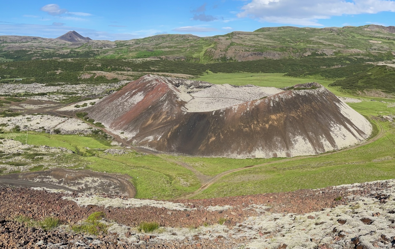
Just about 20 miles north of Borganes are three scoria cones (wonder cones) called Grábruk. We c.imbed one of them to get a good view of another.

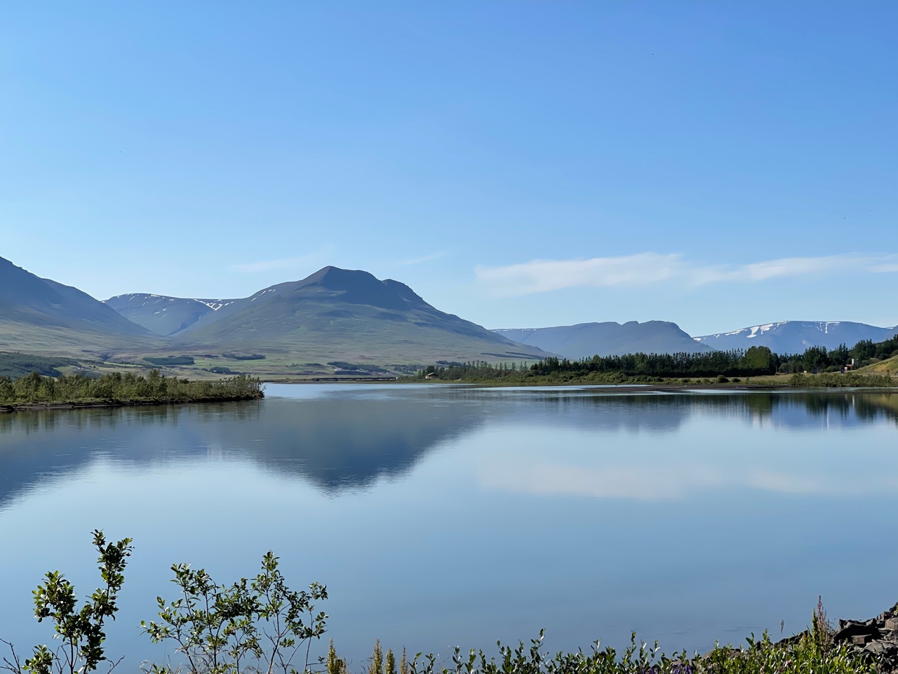
The low hills in the distance are the remnants of a gigantic landslide that came down around 7000 years ago in the area of Vesturdalur. The debris traveled downslope about five miles, coming to rest across the river. The lake was formed in the process.

Farm scenes along the road are a never-ending fascination.

And Icelandic horses are often a part of these farm scenes. To learn more about the character of this unique breed, check out this link.

After our first night in Icelands second city, Akureyri, we made a long excursion east and north with a first stop at the pseudo-craters along Lake Myvatn. Pseudo-craters form when molten lava flows over wet or marshy ground, creating a layer of steam. The steam ultimately explodes through the lava flow to create a crater. Therefore, these features can also be called rootless cones, since they do not have a deep vent with far traveled magma.
 
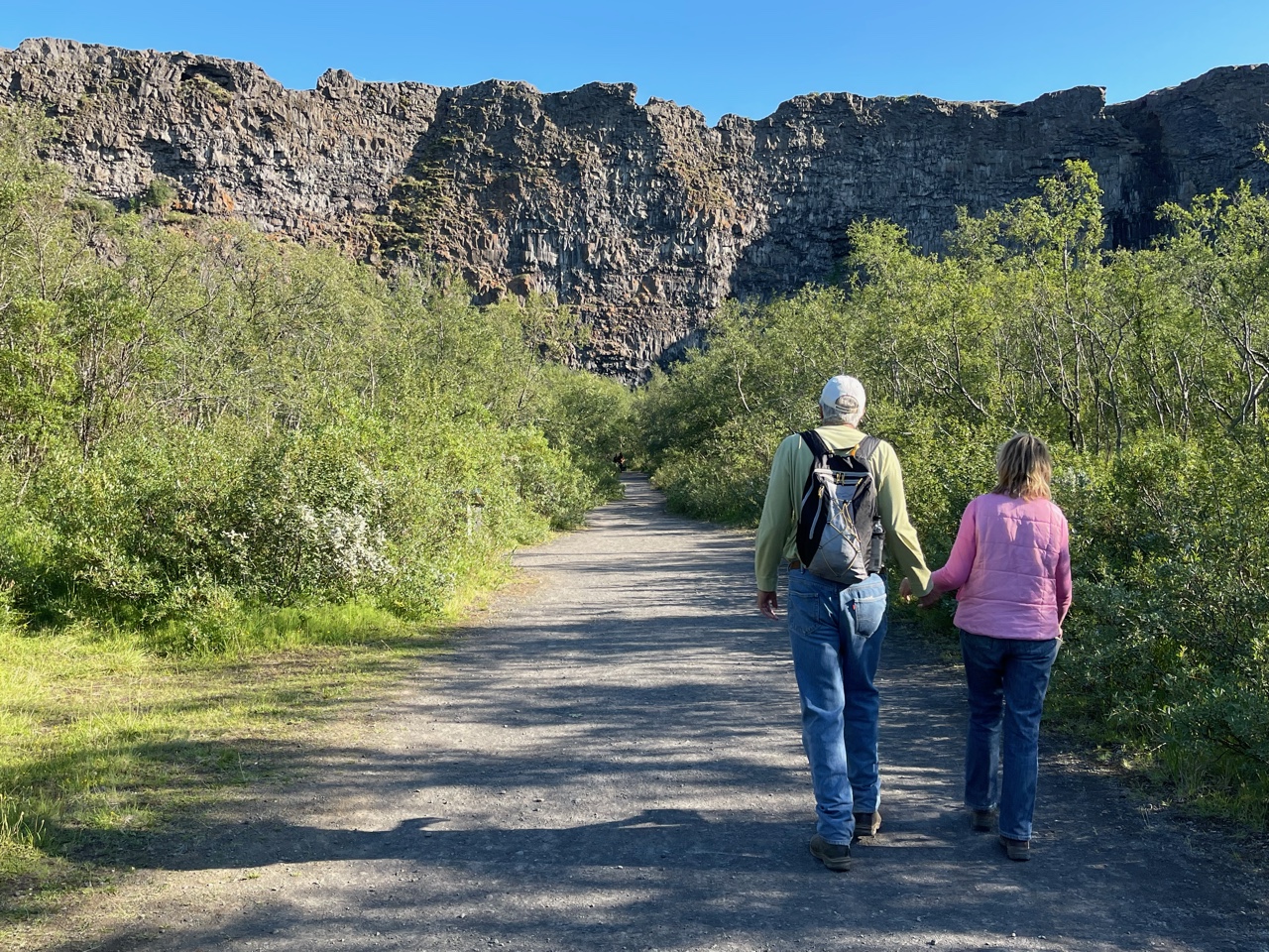
Nearby is another strange phenomena, the craggy towers of hardened lava at Dimmuborgir. About 2300 years ago, a large lava lake existed in this area. While still hot and molten, steam vents rose through the liquid lava, hardening these vents. Suddenly, the lava lake drained through a breach in its walls, leaving the hardened steam pipes standing tall.

While walking on the trail through the strange forms, we passed this outcrop showing where the catastrophic draining of the lava lake was visible. The vertical striations document the lowering of the lava lake.

I had never before been to this location - the exit avenue for the lava lake. It might be a bit hard to see here but a linear valley spills downslope toward Lake Myvatn, visible in the far distance.
  
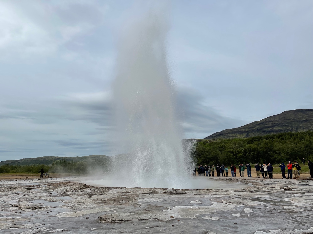
We were once again standing astride the Mid-Atlantic rift, where geothermal activity is everywhere.

A part of the rift is visible from Highway 1 - the mountain has been split asunder. This is a view to the north with rocks on the left moving away from the center as part of the North American plate and rocks on the right moving with the Eurasia plate.
 
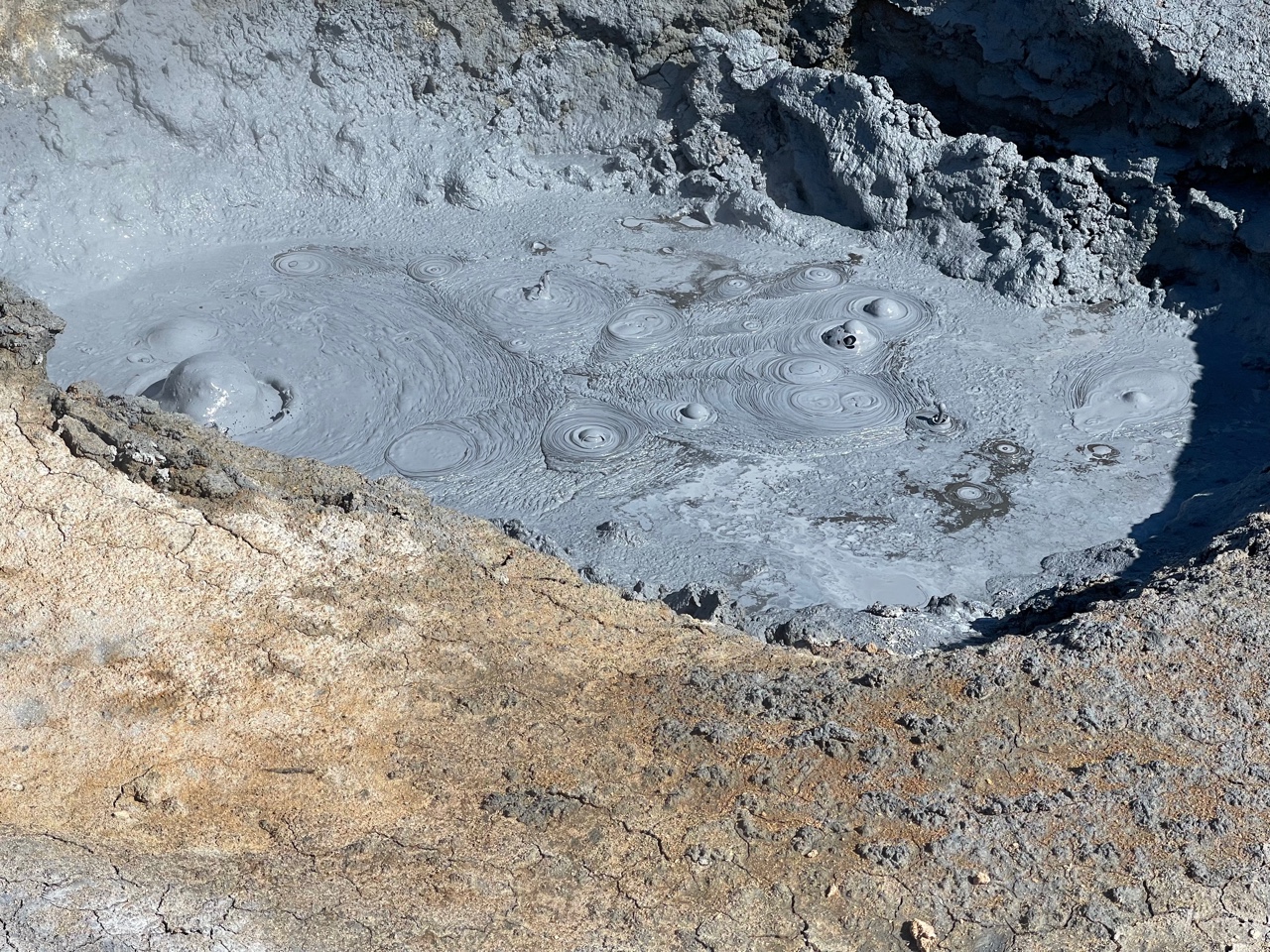
I could watch boiling mud pots all day long and not get bored.

Viti Lake sits in a small crater in the Krafla volcanic belt. This lake was only formed in the Myvatn Fires of 1724-1729.
 
Moving east out of the immediate rift zone, we came to a very large waterfall called Dettifoss. The mist created this rainbow on our blue-bird day!

The water in Dettifoss comes from the Vatnajokull glacier upstream. Therefore the water is muddy and the mist smells like mud. The falls are over 160 feet high.

The parking area for Dettifoss is about one kilometer away. Why would the parking area be located so far from the falls? The answer is that the area has experienced huge glacial outburst floods that have created a channeled scabland. Here is one of the channels from a flood that must have been enormous.

Another view of the channeled scabland. These have happened here three times in the recent past, about 9000, 5000, and 2000 years ago. These are similar landscapes to what is seen in North Americas at the channeled scablands in eastern Washington state from the Missoula floods.

About 20 miles downstream from Dettifoss, we visited Hljodaklettar where evidence of the outburst floods is also visible. Note the canyon carved by these massive floods. This is a view in the upstream direction (south).

The floods carved through a shallow vent system, exposing the plugs in what used to be a scoria cone.

Plucked and eroded volcanic vent at Hljodaklettar.

The basaltic columns in the plugs were amazing.

Close-up.

And finally, downstream at about sea level is Asbyrgi. Here the floods split around this island of stacked lava flows.

A box canyon has no stream within it today, yet it is scoured by the intermittent floods that roar out from beneath the glacier 80 miles upstream.

Late evening sunlight on Icelands north coast. Thanks for reading!

Friday, July 30, 2021

Iceland's Golden Circle - Mid-Ocean Rifting, Geysers, Waterfalls

Thanks to readers who have written to me about their anticipation of the photos from this trip. I think many people are wanting to get out onto the landscape again after what seems like a long nights sleep. I am fortunate to have two friends who wanted me to show them some sights in Iceland. This post is from Days 2 and 3 of our trip around the Golden Circle route east of Reykjavik, and then out onto the westward-jutting Snaefellsnes Peninsula. 

Day 2 - The Golden Circle

About 40 miles east of Reykjavik is Thingvellir Lake (above). The lake is only about 10,000 years old having formed after the end of the last widespread glaciation in Iceland. During the Ice Age, all of Iceland as well as much of its submerged submarine plateau was ice covered. The ice sheet obliterated much of the topography in Iceland but once the ice was gone many new landforms began to appear.

One such landform is this graben where Thingvellir Lake is found. This is a view of the Western side of the graben. Note how the "crack" has down-dropped and tilted the eastern (right-hand) block in this view. The Oxará River is flowing toward the photographer in the bottom of the graben into the lake behind the photographer.

The trail leads down into the crack. But this is not just any old graben - this formed on the Mid-Atlantic Rift, the gigantic crack where the Old World and New World continents broke apart in the sundering of Pangaea. Yep, this is where the Mid-Atlantic Rift is above sea level!

This is a view to the south along the graben's western margin. Locals tell visitors that the block on the west (right in this view) is a part of the North American plate and the block on the east (center and left) is part of the Eurasian plate. The width of the rift however is about 5 miles and so the simpler explanation is partly right. There is a five mile wide gap between the two major plates and the graben floor represents this gap.

The Oxará River tumbles down over the rift fault.

Next stop is Geysir (not incorrect spelling - Geysir is a place in Iceland that all of the worlds geysers take their name from. We just loved hearing the Brits telling us how much they loved this Geezer.

Geysir was quite active until an earthquake in the early 20th century changed it plumbing and it hardly ever erupts now. The photo above this is of a geyser called Strokkur and it erupts once every 5 or 6 minutes! It's easy to watch it over and over again. Imagine if the earthquake had happened a mere few hundreds of years before it did - then all of the world's geysers might be called strokkurs.

Gullfoss (Golden Falls) on the Oifusá River cascades over two resistant ledges of basalt lava. The middle platform is across weakly cemented gravels.

The upper half of the falls.

Natural basalt columns form parking barricades in the parking lot.

We attempted something I had never done before - we kept going on the road past Gullfoss! We got very close to the Langjokkul Glacier.

Many of the landforms in Iceland were created as sub-glacial volcanoes, meaning. that eruptions continued no matter what existed above them - such as a giant ice sheet. Some of their forms are amazing to see.

Day 3 - Snaefellsnes Peninsula

I had never in all of my trips to Iceland seen the very top of the Snaefelsnes volcano but on this glorious July 28 day it was visible. It exists as the ultimate landform on a westward-jutting peninsula into the North Atlantic.

Not all of the volcanic rocks are basaltic in Iceland. Here is a rhyolite dome that formed sub-glacially. It is mantled with scree.

The church at Budir was built in 1834.

Jules Vern's "Journey to the Center of the Earth" (1864) was set a this volcano. This is where the intrepid explorers in this work of fiction entered the earth.

Typically Snaefellsnes scene. Farm, mountains, waterfall. Repeat. Farm, mountains, waterfall.

Slot canyon hike.

Opening to the slot canyon.

We drove on a dirt road onto the shoulder of the volcano.

This is another subglacial volcanic center, albeit a small one.

Tranquil day on the North Atlantic. View to the south.

Erosional windows in the basalt.

The harbor at Arnarstapi.

Another view.

The church at Arnarstapi. Wish I had time to flesh out more photos and descriptions!