Saturday, February 20, 2021

Earth's Changing Climate Highlighted in Atlantic Article

The Atlantic recently published an article called, "The Terrifying Record Lurking in Earth's Ancient Rock Record" by Peter Brannen. I highly recommend reading the article to get a flavor for the many interesting (and sometimes frightening) changes that have occurred in Earth's climate since the end of the Thermal Maximum about 55 million years ago. You can read the article here.

The article is a nice synopsis or review of Earth's climate since the dinosaurs went extinct, at a time when Earth's climate was much warmer. I think it could be used as a primer on seminal events that we know happened in the geologic past. 

I really like seeing geology get this much press! 

In the end, I think long and hard about our attempts to control the climate. Even if we were not the cause of the current climate change, our geology would inform us that this change has been ongoing and is a huge shaper of all living things. When we as individuals were born, the depth of knowledge concerning how the Earth operates was unknown. We were still just identifying the various “parts” that came with the planet. Our lives have commenced with the progressive “assembly" of these disparate parts with the result being something far different than the disassembled parts could convey. We have lived through a revolution in Earth knowledge, such that its immensity has not yet truly sunk in to us as a species. This article attempts to help us understand the long arc of Earth history and to connect the dots. What a scary, beautiful, unpredictable planet system we have been born into!

Wednesday, February 10, 2021

To the Border in Organ Pipe Cactus National Monument

In the final ten days of January, Helen and I traveled down south to the beautiful Sonoran Desert. I had been invited by the interpretive rangers and resource managers at Organ Pipe Cactus National Monument to do a little geology instruction for seasonal rangers. I was honored to be asked by their Chief of Interpretation, Jessica Pope. Organ Pipe is a spectacular desert landscape that I first visited in the late 1970s. It is known mostly for the odd columnar cactus that gives it its name and that enjoys a habitat that barely makes it north across the international boundary with Mexico. In this post, we'll learn a bit about the landscape there, one of the major springs in the area and see photos of the newly established "wall" along the border.

Part 1 - The Approach

Our trip began with another volunteer gig - working at the Covid-19 vaccination site at State Farm Stadium in Glendale Arizona. Here Helen is getting trained on using the iPad for checking people in. The cars in the background are being verified at the first station. If everyone in the vehicle has a valid appointment for that day, they are waved to the right and into the inoculation lanes. If anyone in the vehicle did not have a valid appointment for that day (but at least one person did), they were sent to one of our lanes (10 in total). It was nonstop vehicles for us from 2 to 10 PM! It took about 10 minutes to check each person in - we estimate that we checked in at least 40 vehicles and 50-60 people on our shift. Still, it was worth it to help out!

Our next stop was Tucson to see our grandson Jordan, attending the University of Arizona as a pre-Med student. While we were there, it snowed! Not a totally unheard of event in Tucson but it doesn't happen every winter.

On the way from Tucson to Organ Pipe, we passed desert ranges with snow coming all the way down to the highway. These are the Coyote Mountains, southwest of Tucson.

Along the way we saw this cristate or crested Saguaro cactus. See this National Park Service site bulletin that explains this odd growth pattern in the cactus.

This is the map of Organ Pipe Cactus National Monument, which is about 330,000 acres (133,550 hectares). Our training drive went on the Puerto Blanco Drive, shown on the map beginning at the Kris Eggle Visitor Center (green banner) and we traveled anti clockwise on the road shown in black, making stops along the way. NOTE: That the round trip on the Puerto Blanco Drive is currently closed to all visitors during "wall" construction. I was allowed to journey on the road with NPS personnel for the interpretive training exercise. This road may reopen in March or April. Please check at the Kris Eggle Visitor Center for all current information about road closures. 

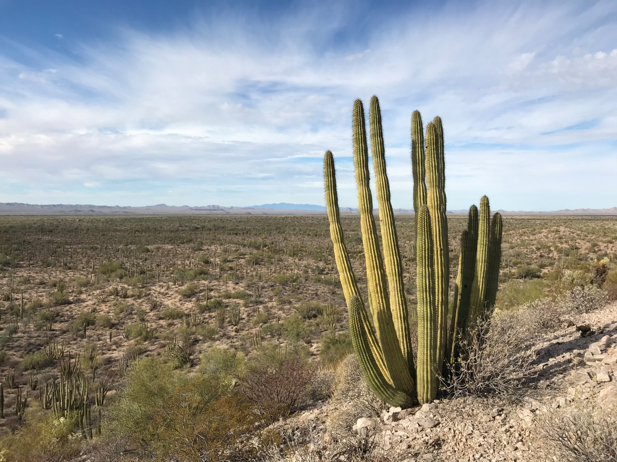
A nearly full moon rises over the Ajo Mountains and young saguaro cactus (Carnegiea giganticus). Even the folks in Saguaro National Park near Tucson admit that Organ Pipe has more robust stands of these desert giants. And it is the young ones that seem to dominate here. It is about 75 years before they begin to grow arms.
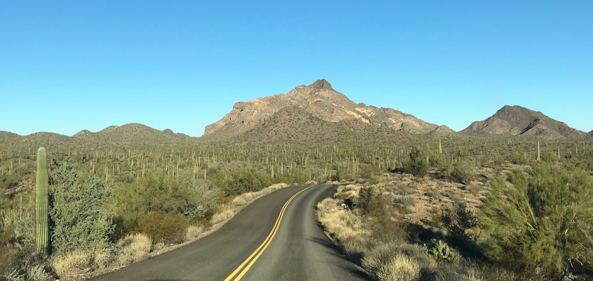
Part 1 - The Puerto Blanco Drive

Leaving the Kris Eggle Visitor Center and heading north on Puerto Blanco Drive. The pavement ends after a few hundred meters. That is Pinkley Peak straight ahead in the distance, composed of mid-Miocene (about 17 Ma volcanic rhyolite tuff and lava).

Readers of this post will find a copy of a geologic map of Organ Pipe Cactus NM at this link. There is a KMZ file available in the link, which opens an interactive geologic map in Google Earth. Users can click on any colored rock unit and find a description of it. The legend for the various rock units is there was well. On this image, I have zoomed in to a section that includes the Puerto Blanco Drive that we completed on January 27, as well as two hikes in the Monument. Check out the map using the link above.

This was the location of our first hike to Dripping Spings. Note the ash flows and tuff in th background.

Dripping Springs in a small alcove of rhyolite rock.

The view back to the northeast and the valley floor. Over 70% of the Monument is covered by alluvial fill. Therefore, the rock outcrops are the lesser part of the landscape. Similar rocks underlie the valley fill bit were downdropped during the Basin and Range Disturbance, which affected this area after about 16 Ma. The rhyolite eruptions that produced these rocks ceased shortly after their emplacement and were pull apart as the transform morion of of the proto-San Andreas fault began.

Organ pipe cactus and the Puerto Blanco Mountains.

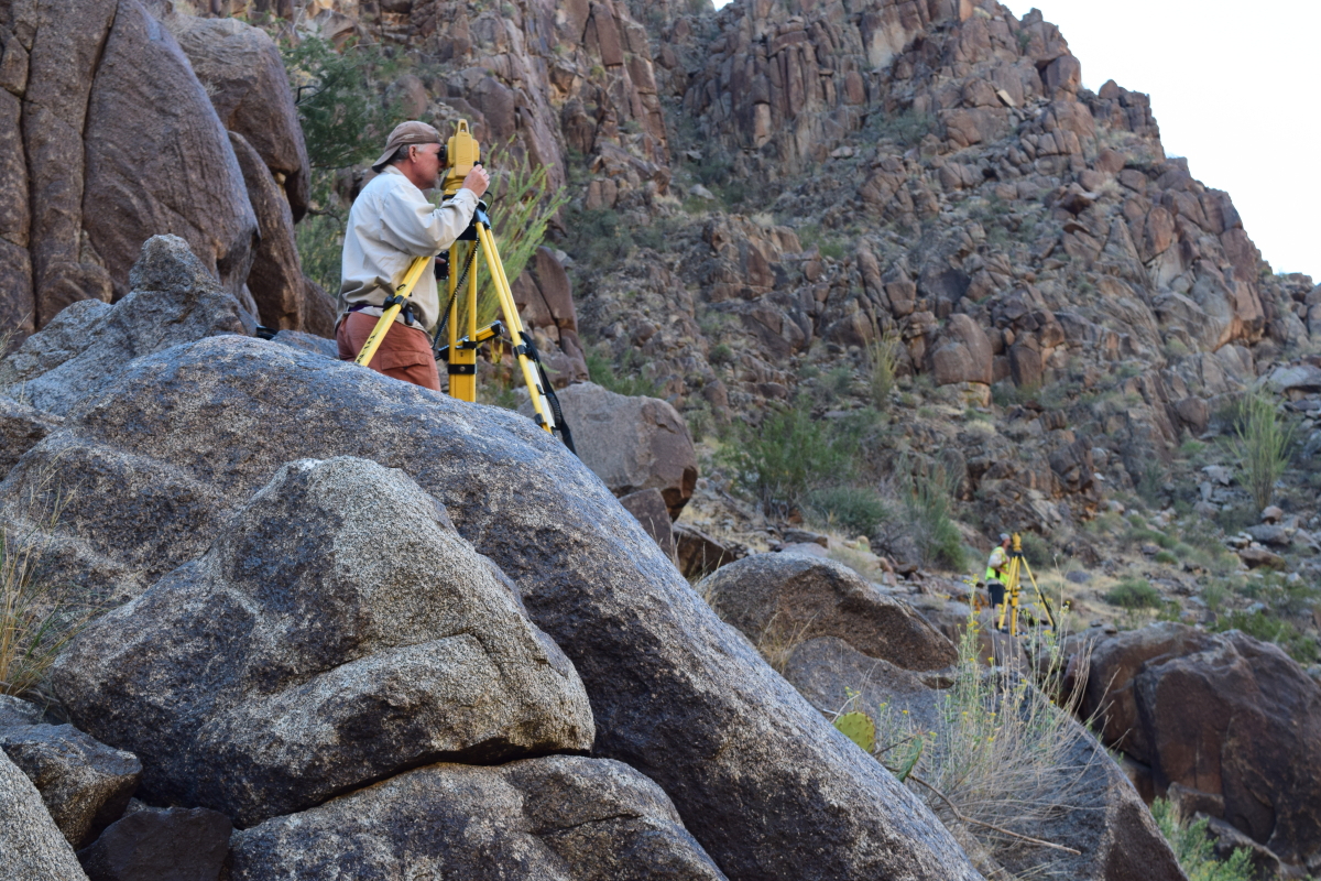
Rijk Morawe is the Resources Manager at Organ Pipe and led the field trip. He has worked here for nine years and loves it. His passion for the place is infectious. The other folks are seasonal interpreters who wanted to improve their geology skills.

This is the Golden Bell Mine. Note the quartz dike behind the metal-covered shaft.

The trend of the quartz dike to the northeast.

We stopped for lunch at the old Bonita Well. 

This is the junction of the Puerto Blanco Drive with the Pozo Well Road. The view is north along Pozo Well Road. This is where the Puerto Blanco Drive is closed to further travel at this time due to construction of the "wall." Note the safety beacon in the background. If someone is lost in the desert and out water, food or shelter, they can press a button on this antennae and the Customs and Border Patrol will hurriedly come to greet you.

Warning sign of illegal activity.

And then we arrived at the International Border. This "wall" has been constructed within an eight-month period. You may have noticed that I have placed the word "wall" in parentheses throughout this posting. That is because I think it is more properly called a fence. A wall is something one cannot see through.

You can see through the bollards and so technically, it is not a wall but a fence. Solid metal sheets makes up the top four feet or so. It must be able to stand up to attacks from sledgehammers, pick axes, torches, and other tools for at least 30 minutes.

It is a very high fence at 30 feet!

Tom holds a cross-section of one of the bollards. They are set about 6 feet into the ground (concrete) and then the space is filled with the same.

These gates are meant to let monsoon flood water through when needed. I'm not quite sure how they operate? There is no question that the fence was constructed much too quickly. No matter what your feelings may be about the border, immigration, or illegal entry into our country, the fact that environmental studies were curtailed for this project means that a satisfactory understanding of the natural landscape and its many nuances is lacking. Any sheet wash flood will wreak havoc on this fence. Not to mention that it is barrier to wildlife migrations and water. The fence is a short-sighted attempt to fix an admittedly big problem. I have traveled to many different countries and see how their immigration systems work. We do not even have an immigration policy at this time. The fence is interesting but not for reasons that are beneficial.

Along the fence.

We gave three feet of our country to Mexico with this fence. As I peered though the bollards, I could see one of the original boundary obelisks for the border. Check out this story in The Guardian about these.

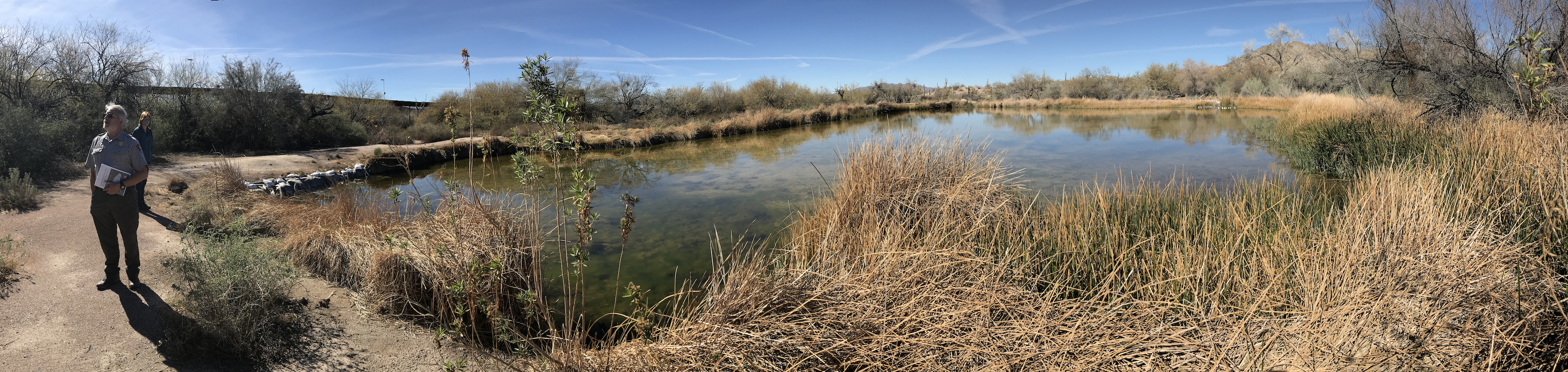
Right along the border is Quitobaquito Spring. I first visited here in the late 1970s.

It is a wonderful oasis in the desert. This is a panorama shot of the basin that was carved out by ranchers in the 1930s. The distance across is about 150 feet.

Rijk talks to the group about the importance of the spring. I wanted to show the proximity of the International Boundary to the spring. When I first visited here in the late 70s, there was a three-strand barbed wire fence here. The fence was upgraded in the early 2000s to a vehicle-proof barrier after a Park Ranger lost his life to cartel members. That version of the fence was about four feet high.

The National Park Service has funneled the spring water into the pond as the discharged has gradually been lowered since about the 1990s. Then, nearly 25-27 gallons per minute issued from the spring. It has slowly diminished to about 9 gallons per minute. Still a lot of water for its location but with an alarming trend. Agriculture just south of the fence is likley not the cause and the flow of groundwater is likely from the La Abra Valley to the northeast of the spring.

There are native pup fish in the water here! They are the Sonoyta pup fish (Cyprinodon eremus). See a photo of one in this link. We saw many in the pool behind Helen.

Day 2 - Senita Basin to the Visitor Center

The next day, I went again with Rijk to help him with some of the geology in the Senita Basin. This is the plant that gives rise to the Mexican Jumping Bean, (Sebastiania pavolana). It is actually a larvae, that has been planted into the seeds of the plant by a moth. The larvae wiggle to scare away predators. I remember buying these as a kid in Tijuana.

The basin receives its name from this cactus, the Senita or Old Mans Beard (Pachycereus schottii). This is an even rarer cactus in the USA and the Senita Basin could be its own "Monument Within A Monument!"

Can you see the fence in the distance? We are standing on Laramide-age granite looking southwest.

It was a beautiful day.

The Victoria Mine.

A last view of the Victoria Mine. This was likely a gold and silver prospect that played out enough to have significant infrastructure.

I want to thank the rangers and managers at Organ Pipe Cactus National Monument, especially Jessica Pope, Chief of Interpretation for extending the invitation to us to come and help interpreters, and Rijk Morawe, Chief of Resources Management who led me on two outstanding field trips! This is a gem of a Monument that needs to be a National Park - and soon!

Monday, February 01, 2021

California's Highway 1 Near Big Sur Washed Out Again

Image from the San Francisco Chronicle

California's storied Highway 1, hugging the Pacific shoreline near Big Sur, has experienced yet another catastrophic wash-out. The location this time is where Rat Creek enters the ocean, almost due west of King City along Highway 101. Highway 1 is now closed from just north of Ragged Point on the south to Nepenthe on the north. This is south of the area generally described as "Big Sur." The flood occurred on Thursday January 28 after heavy rain fell in the area. Seven inches of rain fell along the coast and up to 16 inches in the local mountains.

The same area was the site of the Dolan Fire that began on August 18, 2020. It was only fully contained on December 31. The confluence of wildfire and subsequent wash-outs along streams is a common occurrence. The highway was closed for 8 months in 2017 when a similar atmospheric river dumped heavy amounts of rain along the highway north of this event.

Read a descriptive text of the event on the American Geophysical Union Landslide blog here. Also, the San Francisco Chronicle has a great article with many photos here.

Dear friend Joan has brought my attention to the blog of 'Big Sur Kate'. Please check out her blog about the wash-out here. Included in her post of this wash-out is an additional link to excellent highway maps with individual mile markers for Highway 1. Find that and included links here.

Friday, January 08, 2021

Wealth of New Images of the Valles Marinaris on Planet Mars

The planet's famous red colour
is from iron oxide coating everything.
So it's not a just a desert.
It's a desert so old 
it's literally rusting.
 
Andy Weir, The Martian

On January 7, NASA released new images of the Valles Marinaris on Mars. The images are stunning and can be accessed in a web link I found online here. Be sure to watch the animation contained with the 3rd graphic! It is a flyby around the canyon and is spectacular. Also, be sure to use this link to a University of Arizona page where other images can be seen.

Valles Marineris shown at an angle of 45 degrees to the surface in near-true color and with four times vertical exaggeration. A larger image can be had from the link in the paragraph above. The image covers an area of over 243,000 sq. miles with a ground resolution of about 300 feet per pixel.The largest portion of the canyon, which spans right across the image, is known as Melas Chasma. Candor Chasma is the connecting trough immediately to the north, with the small trough Ophir Chasma beyond. Hebes Chasma can be seen in the far top left of the image. This image was first published in 2009 in the European Space Agency  science monograph Mars Express: The Scientific Investigations.

What a time to be alive! Earthly space ships orbiting other planets with high resolution photographs!

Wednesday, January 06, 2021

Fantastic Video and Images from the Current Eruption at Kilauea Volcano, Hawai'i

The Kilauea volcano has entered its second week of the current eruptive activity. A lava lake has developed on the floor of the crater and is evolving rapidly. This 3:45 video from Big Island Video News and the USGS has fantastic footage of crustal rafting, doming, and other processes that are common in these type of eruptions. There are also thermal images included. Watch the video here


Monday, December 28, 2020

A 17-Day Rafting Trip with the Grand Canyon Monitoring and Research Center

In October of this year, I completed a 17-day rafting trip on the Colorado River in Grand Canyon. We experienced perfect weather on this trip; the few times there was a breeze it was always blowing in the downstream direction. I worked as a volunteer as part of a vegetation survey, linked to a larger and longer survey concerning sand bars and beaches along the Colorado River in Grand Canyon. Scrambling through the dense riverside vegetation was very tough work and I found the going quite tough. Fortunately, I was working alongside Dr. Ryan Crow of the US Geological Survey who was much more agile through the brush than I. We both served as volunteers on this trip in order to travel together and field check our upcoming "Geologic Guide to the Colorado River in Grand Canyon" (working title). The field work was a great success!

Matt Kaplinski and Joe Hazel are lead investigators on this long-term monitoring project and are former classmates of mine from the 1980s at Northern Arizona University. They note that, "The work we do and the data we collect are important and get used by the Dept. of Interior and the stakeholders of the Adaptive Management Program in Grand Canyon." A very interesting and interactive time-series of the sandbar data can be viewed here

This is mostly a photo essay of our trip and I provide only short captions where desired. Enjoy the trip!
 
Matt Kaplinski rows our boat through the Inner Gorge. Dr. Ryan Crow sits on the tube (right). Photo by Geoff Gourley.

Dissected talus aprons in the Hermit Formation.

Which way does the river go? The answer will be in the geologic guide but the answer is, left. A barbed tributary (a stream that enters the master trunk against its downstream direction) called Soap Creek comes in on the right.

Reptile trackway on an upright boulder on RL (River Left) at RM (River Mile) 15.0.

Sheer Redwall Limestone cliff near RM 27.0
 
Stanton Cave on RR at RM 32.0. This is a geologic gem of a cave! Fossils of Harrington's mountain goat, teratorn (large carnivorous birds), river otter, horse, and camelid have been recovered from it. Over 80 split twig figurines were found as well. 

Chemical weathering on a Redwall boulder in camp at Nautiloid Canyon.

Part of the sandbar survey with Namdor's (Rodman spelled backwards).

Obvious contact of the newly described and blocky Frenchman Mountain Dolostone (above) underlain by the more thinly bedded Muav Limestone (below). Photo on RL near RM 36.8. 
  
Boat in repose at Buck Farm Canyon.

Gunner stands opposite the Namdors to take location readings of the sandbars.

Dr. Ryan Crow points out the rocks.

View downstream to Nankoweap Mesa, where landslide deposits rest on top.
 
Colorful Bright Angel Shale.

Ripple marks in the wet sand.

Smooth sailing in Marble Canyon.

Grey's Castle on RL at RM 55.5 is composed mostly of Muav Limestone.
 
Travertine buttress adjacent to the Bright Angel Shale below Kwagunt Rapid. Then travertine is dated between about 100,000 and 400,000 year old.

It was actually hot some days.

Exposed ripple marks along the Colorado River at Carbon Creek.

The wind has sheared the ripples into sastrugi-like forms.

Looking upstream at sunset from the beach at Basalt Canyon.

Looking downstream at sunset from the beach at Basalt Canyon.

The Colorado River meanders below Comanche Point.

Two fresh rockfalls can be seen beneath the Palisades of the Desert.

The dike at Hance Rapid runs through the red Hakatai Shale.

From Zoroaster beach looking up to the Great Unconformity, where the Tapeats Sandstone is thinning across (left to right) a crystalline rock highland.

There were 8 boats in our entourage.

A tamarisk tree grows out of a bedrock knob in the river near Salt Creek.

Pegmatite within the Zoroaster Granite at Schist Camp.

Vishnu Schist foliation near Emerald Rapid.

Contrails turning to cirrus clouds on October 9, 2020.

The Monument fold at RM 116.3.

Fluting carved by the river within the Elves Chasm Gneiss, the oldest rock unit in the canyon at 1,840 Ma.

Two rusty brown dolostone beds within the Bright Angel Shale in Conquistador Aisle. These beds make excellent stratigraphic markers in the canyon when it grades westward into the "limestone wilderness."

Curious extensional features in the Middle Granite Gorge.

One of my favorite features in the canyon is the onlap of the Tapeats Sandstone (brown cliff, lower left) onto the uplifted, tilted and eroded edge of the Shinumo Sandstone (same colored cliff disappearing behind the right hand shadows). Note the different bedding angles between the two rock units.

I sat and watched this dragonfly  for 30 minutes as it hunted in the mouth of Matkatamiba Canyon.

A small paleovalley in the Redwall is filled with the Surprise Canyon Formation at Fern Glen Canyon.

The ever-perplexing Red Slide at RM 175.3 is likely formed from a series of rock falls from cliff failures above. Some sections of the debris are rich in red Supai boulders, others in gray Redwall boulders. Coarser material is often on top of finer material. 

Vulcan's Anvil at RM 178.3 is a volcanic vent within the river! The long Black Ledge lava flow (86 miles long) may have issued from this vent. The plug is dated at 530,000 + 30,000 years.

At RM 212.6, black granodiorite forms a small bedrock gorge along the river.

An upstream view of scoured potholes in Tapeats bedrock and limestone boulders at RM 212.9.

Joe Hazel "guns" a beach upstream from Diamond Creek. This was the 45th and last beach surveyed on this trip.

On October 6, 2020, I marked my 45th anniversary as a member of the Grand Canyon community. On October 6, 1975, I started down the Bright Angel Trail as a volunteer with the National Park Service. What a life the canyon has given me! 

For the first time ever, I was the oldest person on the trip. That awareness came to me about halfway through the trip. What an article of note!

Photo by Geoff Gourley.