Monday, December 31, 2018

A Six-Day Mule Trip to the World Heritage Cave Paintings in the Sierra San Francisco, Baja California, Mexico - Day 3

It was now time to move on to another arroyo. Our vaqueros told us that we would undertake an eight-hour day in the saddle as we climbed out of Arroyo San Gregorio and traversed the upper plateau, before descending into Arroyo Santa Teresa. All of us shuttered at the thought of an eight-hour ride. Although there seemed to be no long-term aches and pains from riding the mules, it certainly was not a Sunday drive either. When first dismounting, we all would wobble a bit and move around bow-legged. And this was only after rides of one hour, two hours or five hours. It would take all day in the saddle today to arrive our destination.

You can see our pack animals in the background getting ready to leave. In the foreground is the remains of the old tanning vats where leather used to be tanned. A large cowhide held the liquids and was tied to the wooden frame. We heard from our guides that they tanned their own leather until about 20 years ago and what you see here is the vats crumbling away. They now obtain their leather from Sonora across the Gulf. Things are changing here in the modern world.

The exposures of volcanic rock in the walls of the arroyos was impressive and represent the debris that was blasted out of the central vent in huge, Plinian eruptions (also called Vesuvian eruptions). These are the most powerful kinds of eruptions, sending rocky material into the stratosphere. Look at the size of the rock in this wall near Rancho San Gregorio. Imagine the force needed to blast a rock this size miles away from the central vent. This was once a very dangerous place.

This is the slope we needed to climb to reach the upper plateau. The cactus forest was beautiful along the way.

Looking back down into Arroyo San Gregorio after making the climb out. Our initial ride in can be seen on the skyline to the far right, just right of the flat-topped mesa.

The last pull to the top. The Tress Virgenes volcanoes can be seen in the far distance.

The upper plateau is a surface of volcanic rock with nearly no soil at all.

Riding across the plateau.

About half-way through the day's ride, we came to a tiny rancho called San Pablo. The scene was  like something out of the old west and the only clue to suggest that it was not from that time period was the rooftop solar panel. This had been installed just two years prior and now the residents have a small freezer to keep goat meat and goat cheese from spoiling. There are no roads into this remote dwelling of five people and it is a tough all-day ride to the nearest road.

Our guides had been busy making burritos for lunch during our breakfast and they were delicious with the fresh brewed coffee.

Our group is enjoying burritos and coffee at Rancho San Pablo.

And then we were off again across the high plateau. This was wonderful riding and as you can see the weather was perfect. Note how green everything is on this high plateau.

A couple of lone boojums appeared on the west edge of the upper plateau. This view is to the northwest.

After many hours in the saddle we finally reached the edge of Arroyo Santa Teresa. It appeared to be as deep as San Gregorio but the appearance was deceiving as we peered down into the afternoon sun.

The trail dropped off steeply and never let up. When riding down such steep slopes, we needed to lay back in the saddle to change our center of gravity. If one was not paying attention, you could topple forward over the head of the mule. The brush grew close to the trail and we often had our legs pulled backwards as the mules scuttled down the slope.

Did I mention the rocks? Look at the bed of the trail - it is nothing but angular volcanic boulders! Yet somehow, these little mules knew where to put their hooves so as to make the journey downward safely without an incident. I came away from this trip with an entirely new appreciation for mules. I have spent the last 43 years of my life hearing from mule riders in the Grand Canyon how scary the trip down to Phantom Ranch was. Those trails are groomed, maintained and five feet wide! Those mules are twice the weight of these Mexican mules. Yet I never felt as if I was in danger here, even though if the mule did fall at any point in this descent the outcome could only be imagined as terminal! The mules seemed to take the entire journey in stride. Looking back, this descent was a highlight for the sheer danger and exposure and the beauty off it all!

Christine and Orlando lay back in the saddle on an especially steep grade. This part of the trip took about 45 minutes before it began to become only a normal slope. The plateau edge can be seen on the skyline in the back.

George poses with his mule as we take a short break from the perilous descent. We had all signed on for a trip to see the cave paintings by mule support. And what we got was a fantastic mule trip - and oh yeah, there were some cave paintings along the way.

An organ pipe cactus (Stenocereus thurberi) frames the view down to a thick layer of volcanic debris. The afternoon light was brilliant.

We finally arrived at our camp for the next three nights, next to Santa Teresa Creek. What a day in the saddle it was! Now we could relax a bit and clean off in a pool of water. We would have two full days to explore the alcoves near this spot.

A Six-Day Mule Trip to the World Heritage Cave Paintings in the Sierra San Francisco, Baja California, Mexico - Day 2

We were now camping comfortably at a remote rancho on the floor of Arroyo San Gregorio in central Baja California. After an early breakfast (out of our tents before light) we hopped back on our mules to begin an exploration of the nearby caves. Surprisingly to me, I was not saddle sore from the previous days' 5-hour ride. These little mules seemed to have a gait that was simpatico with the trails. What a welcomed surprise this was.

We followed the stream bed through a paradise of cactus - cardon, cholla, pricky-pear, organ pipe - the list goes on. Everything was green beyond belief as a result of the recent rainfall. Onward the mules carried us through this verdant stream bed.

After about an hours' ride, we turned up into a side gulch and the mules trudged up a short but steep slope. And there we were at the mouth of a cave known as San Casimiro. Note that these features are referred to as 'caves' but technically a cave is a reentrant into a rock where natural light is lost completely.  These were obviously not that deep and more correctly these are known as alcoves.

Our first view of some of the rock art. Notice the red, and black features on the alcove roof.

A closer view of some of the smaller elements found here.

Later in the morning we moved to an alcove called La Familia. This was one of the best rock art sites in the whole range. Larger elements were evident here and on the far left is a deer springing into action with anthropomorphs - human-like figures - just above the observers heads.

George admires a closer view of this panel. You can get a sense of the tremendous size of these figures.

Almost invariably throughout the Sierra San Francisco a bicolor pattern repeats itself with the black color being on the left (or bottom) and the red on the right (or top). In a only a few instances is this reversed. Our local guide mentioned that the two colors might represent day and night to the originators of the art. Of course, we will likely never know - the people who created these works of art are long gone. But rock art has become in recent decades an avenue of research to archaeologists and some things can be known.

These is not much material here than can give a clue as to where these people lived - there are no remnant structures of any kind within the alcoves. However, ground stones such as manos and metates are found and these were likely used to grind rocks to make the paint. (They could also have been used to grind seeds into meal). Our local guide found a reddish rhyolite rock that he quickly hammered into red powder. The black may have come from charcoal. Both colors would have mixed with fixative agents such as tree sap or pulp, urine, or other substances.

The proximity of the Sierra San Francisco to both the Pacific Ocean and the Sea of Cortez must have been important to the people who lived here as marine rock art elements are common. Two marine turtles (red) are seen next to a ray (black).

Depictions of baleen whales are also commonly seen in the rock art.

Like a shadow cast off from a fire onto a nearby wall, an anthropomorph appears to stare down at a strange unknown traveler from the future.

A close-up of the same element reveals a yellowish head cap. This may depict a feather headdress. Also, this is one of the rare instances where red is on the left and black on the right. Was this an outsider? A holy man or woman?

The old and the new! From left, Bryan, Chris, Orlando, Christine and George. What a great group of friends to share the experience with!

Bighorn sheep were also seen as elements on the walls in many caves. Today, the bighorn do not care to compete with the goat herds that graze here and thus have moved to the east to reside on the slopes and plains around the Tres Virgenes volcanoes.

A last look at the alcove of La Familia.

In the afternoon we walked to two other alcoves, San Gregorio 1 and San Gregorio 2. This is an upstream view of Arroyo San Gregorio from the first alcove.

Very large figures were found in this alcove.

And they were still very brightly colored. Of course, visitors want to know how old the rock art may be. There is no direct way to date the art but the material artifacts found in some of the alcoves give radiocarbon dates as old as 9,800 years, making them some of the oldest rock art examples in North America. Other dates from these alcoves suggest that some of the elements are as young as 3,000 years.

Birds and rabbits (or anterless deer) are depicted here.

Stunning rock art in Arroyo San Gregorio.

George admires a very large baleen whale on the roof of San Gregorio 2. This would be our last night camping near Rancho San Gregorio and the next day we would be on our way to Arroyo Santa Teresa to the west.

Sunday, December 30, 2018

A Six-Day Mule Trip to the World Heritage Cave Paintings in the Sierra San Francisco, Baja California, Mexico - Day 1

NOTE: This will be a multi-part posting.

Approaching the Sierra San Francisco, an incredible desert wilderness in the heart of Baja California.

After two weeks sea kayaking and exploring in the south of Baja California, six of us still had one another adventure in mind - a mule supported expedition into the heart of the Sierra San Francisco. The range straddles the state line between Baja California to the south and Baja California Norte. This is a very remote range with no more than 200 people living on the plateaus and in the canyons of this 25 million year old volcano.

Location map showing the location of the Sierra San Francisco in central Baja California.

After a steady climb along 30 miles miles of paved road, we arrived at the ecoturism center on the outskirts of the village, San Francisco de la Sierra.

A view south toward the volcano center. The high skyline on the left is made up of the intrusive, central vent rocks with erupted ash flows seen tilting to the right on the right skyline. Our trip would be made entirely within eroded layers of ash flows that emanated to the north out of this volcanic center.

We met our vaqueros at the trailhead where they were organizing all of our food and gear for the six-day expedition. We had four vaqueros who traveled with us the full time and two more, each of who were with us for half of the trip. We also had two interpreters/guides.

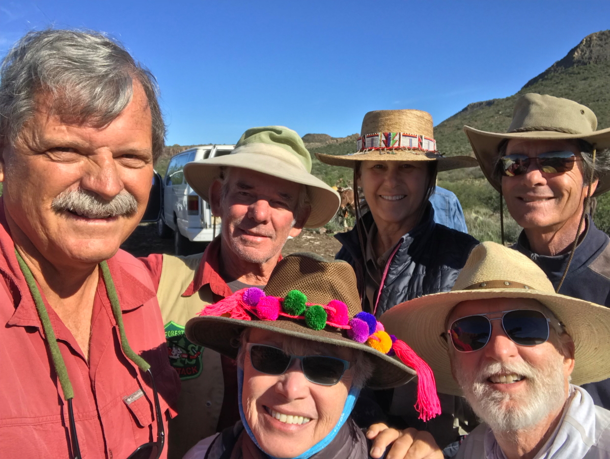
Our lucky group! From right,  back row: Orlando M., Christine M., George A., Wayne R., front row from right, Bryan B., and Chris C. I can honestly say that our smiles were just as big at the end of the trip, but perhaps just a bit harder to rally! This was an adventure in every respect. At the start, I wondered if maybe I wasn't fully aware of what we signed up for.

We are finally on our way across the upper plateau.

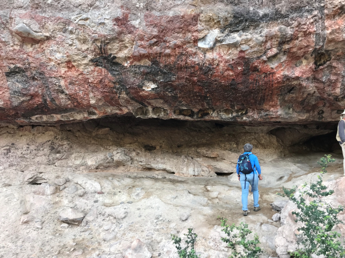
Early on we passed the headwall of Soledad Canyon. We would visit a cave art location in this canyon on day 5.

We had 11 burros to carry our food and gear. They were not tied together, nor were they led on the trail. Rather they were pushed along. Occasionally they would get off trail and the single vaquero responsible for their movement would be required to head off and bring them back. We rarely traveled with the burros - they would leave camp after us, then pass us at some location on the trail and beat us to camp. The whole operation had an air of the disorganized but in reality, it was quite the opposite.  The vaqueros and stock worked like a well oiled machine in spite of the momentary madness and confusion.

The boojum tree(Foqureria columnaris) is a member of the Ocotillo family and its English name was given by explorer Godfrey Sykes after a Lewis Carrol book, "The Hunting of the Snark." They are an unofficial symbol of the Baja peninsula.

The leaves of the Boojum are similar to the ocotillo and their presence on the trees here means that the area had received adequate rainfall in the last few weeks. In fact, the remnants of Hurricane Rosa crossed the peninsula on October 2, after previously being the fourth Category 4 hurricane to form in the eastern Pacific. Just two weeks later, the remnants of Hurricane Sergio crossed the peninsula on October 15. The Sierra San Francisco was drenched in both storms and the flowering plants were outstanding this whole trip.

If I had to summarize the landscape of the Sierra, it would be 'rocky.' There are rocks everywhere with very little soil anywhere. This shot into Soledad Canyon reflects the rocky nature of the range.

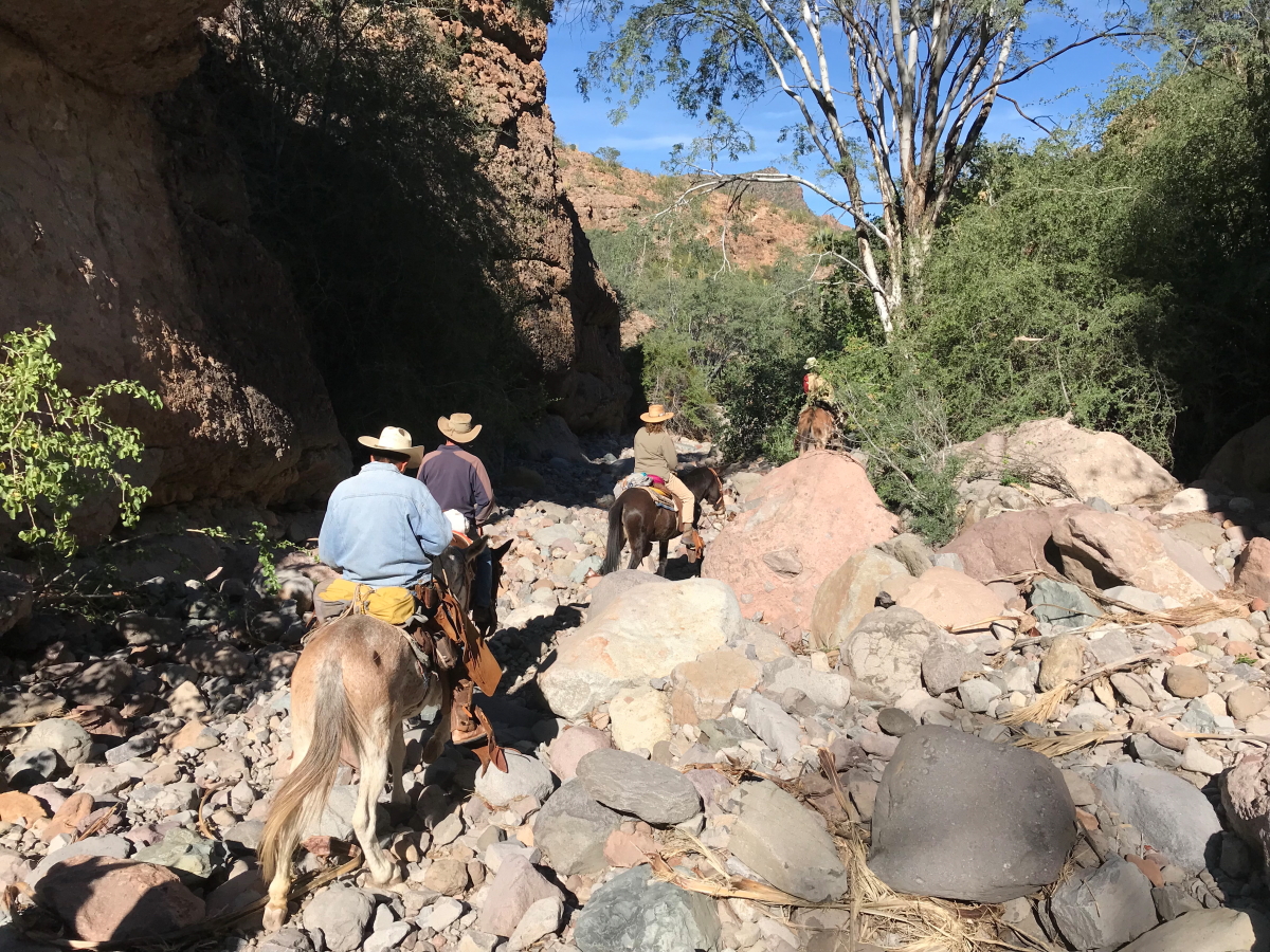
As the trail began to descend into the canyons, we came to a few areas where dismounting was necessary. Here we traverse through as layer of rhyolite lava below the plateau edge.

Mules awaiting the descent of the last mules.

A view of our initial descent.

The are constructed trails (albeit only marginally maintained) that have been in use since the mission days in Baja California. Some of the trails may even follow routes taken by the cave painters.

Finally, as we neared the bottom of San Gregorio Canyon, the Mexican blue palms (Brahea Armata) came into view. These are elegant palms that only grow where there is near-surface water. The canyons of the Sierra San Francisco are lined in groves of these trees.

The rocky bottom of Arroyo San Gregorio

We rode by very fast but here was an important spring that issued from a bedding plane in the volcanic sequence. This water has likely been underground a relatively long time before making its way to the surface.

This is a partial view of the Rancho San Gregorio, where we camped nearby for the first two nights. The abuelita of the rancho cooked our meals.

Here our interpreter is helping with the preparation of the dinner. A wood-fired stove is used along with kerosene and solar lighting.

Chris and Bryan enjoying our first dinner. So ended our first day on the trail. The next posting will include visits to our first cave paintings.