Wednesday, June 27, 2018

Raft Trip in Dinosaur National Monument, Utah and Colorado Begins


I am up in Vernal Utah to begin a five-day float trip through the Canyon of Lodore, Whirlpool Canyon, and Split Mountain Canyon on the Green River. I'll be posting pictures and stories after I return on July 4.

Today I toured the Douglas Dinosaur Quarry, site of the 1909 discovery of a fabulous bone bed in the Morrison Formation and drove the Harpers Corner Road on top of Dinosaur. More pictures to follow after the trip.

The mouth of Split Mountain Canyon.

The Nugget Sandstone (bottom white bed) is the time equivalent of the Navajo Sandstone, is capped by a thin red deposit of Carmel Formation and an upper cliff of Estrada Sandstone on the way up the Harpers Corner Road.

Saturday, June 16, 2018

The 2018 AAPG Geosciences in the Media Award, Salt Lake City, Utah

On May 20, 2018, the American Association of Petroleum Geologists (AAPG) held their annual meeting in Salt Lake City, Utah. As I mentioned in a post previously (December 2 , 2017), the AAPG has granted the AAPG 2018 Geosciences in the Media Award to me for a lifetime body of work. What an honor it is to receive this award from such a prestigious organization.


A partial listing of past awardees in this category is shown below. What an impressive list and I am deeply humbled to become a part of this group:

John McPhee (1982 and 1987)
James Michener (1984)
Rod Redfern (1983 and 2003)
David Attenborough (1986)
Stephen Jay Gould (1993)
Jack Horner (1994)
Wallace Hansen (1995)
Donald Baars (1997)
Walter Alvarez (1998)
Sarah Andrews (1999)
Simon Winchester (2003)
Bill Bryson (2005)
Michael Crichton (2006)
Ron Blakey (2011)
Ben Gadd (2016)
Michael Collier (2017)

You can view all of the past awardees since the awards' origin in 1972 here.

I wish I could have accepted the award in person but was flying back home from Europe on May 20. Nevertheless, I am honored to receive this award. In 2014 and 2016 I received a similar award in the same category from the Rocky Mountain Association of Geologists for two of my books, Ancient Landscapes of the Colorado Plateau and Carving Grand Canyon.

More than viewing this simply as a personal award, I would like to thank the two organizations above who place high value in our field for recognizing professionals who choose a career path centered on the sharing of geology to a wider, public audience. Many awards , rightly go to those who perform original research. Yet our society benefits when they become better informed about all aspects of Earth's natural systems.

Geology surrounds each and every one of us, every day of our lives. Being better informed and in awe of the magnificent palette of geologic wonders makes for a more wholesome, adaptable and accepting society. Personally, I could have chosen the research path in geology as I loved field mapping. But my heart has always moved toward a path that involved sharing the wonders of earth history and earth processes with those who did not have the good fortune (as I have had) to study geology formally.

I would also like to thank my professors at Northern Arizona University who gave me the tools to think geologically. And to the many current researchers who share their findings with me. You are too numerous to mention here but I have learned from your results, incorporated them into my thinking and crafted them into a narrative that "regular" people find fascinating. Thank you one and all for your gifts!


Thursday, June 14, 2018

Comparing and Contrasting the June Hawai'i and Guatemala Volcanic Events

Eruption from Fissure 8 on June 10, 2018. Photo courtesy of County of Hawai'i Civil Defense Agency
Volcanic eruptions on the Big Island of Hawai'i and in Guatemala have recently taken center stage not only on the geologic front but in the national news as well. How do these two geologic settings compare and contrast?

Both locales are located in active volcanic zones and so eruptions are nothing new here. They both produce eruptions of lava and scoria (ash, pebble and boulder-size particles) that originate from magma within the crust. The term magma is used for melted rock still residing in the interior of the earth and the word lava is used when it finally erupts to the surface. That is the difference between those two words although occasionally you may hear reporters use each term in the opposite way.

Eruptive column from Volcano Fuego on June 3, 2018, image from Strange Sounds web site.
Guatemala

While the Hawai'ian eruptions are relatively gentle, the event that occurred in Guatemala on June 3, 2018 was quite explosive. To explain the difference between these two types of eruption styles, we need to look no further than the silica content contained in the different magma bodies. When more silica is contained in the melted rock, the more explosive eruptions can be. Silica adds viscosity (resistance to flow) to magma and the only way escape  route for the included gases found in all magma bodies is to explode violently. As the magma reaches near the surface, the gas expands, reaching a threshold and the only to escape the viscous substance is to explode outward. Thus the eruption on Fuego that sent a scoria cloud nearly 10 miles high.

Chart showing magma chemistry and resulting rock types, original from Wayne Ranney lecture slide 
The web site, Volcano Discovery has good, up-to-date information on Fuego's current activity. I also monitor the Smithsonian Global Volcanism Program for science information. These are both excellent sources but the Smithsonian site contains more detailed information. Check out the general information link on Fuego's home page for an interesting history of this volcano, including a reference to an earlier edifice that began growing on the same spot 230,000 years ago which collapsed in a massive debris-flow avalanche that ran 30 miles out into the Pacific Ocean! Check out this video from Knut Eisermann on FB for excellent footage of the June 3 eruption which, fortuitously for photographers, occurred around noon local time. The explosive eruption emitted ash and lava with a silica content of no less than 65% and as much as 75%. The rocks created from such chemistries are called dacite or rhyolite, respectively.

Three part diagram showing the assembly of the Central American microplate at 20 Ma, 12 Ma and 0 Ma (the present)
The setting of Guatemala is along the Pacific Ring of Fire, where ocean crust beneath the Pacific Ocean is sinking (geologists say subducting) beneath the edge of the Central American microcontinent. When this slab of ocean crust descends to between 60 and 100 miles, it begins to melt and then rises buoyantly through the crust. The subducting plate, called the Cocos plate, is rather long and melting along its edge causes these types of eruptions that occur from a line of volcanoes that stretch from central Mexico to northern South America. In reality, this geologic setting stretches intermittently from Alaska to Tierra del Fuego! Another great site to peruse about the scene in Guatemala on June 3 is called Strange Sounds and you can view images of it here.

Photo of Vulcan Fuego in January 24, 2017 from an area near the village of Esquintla, destroyed by the pyroclastic flow on June 3.  Photo by Don Webster
As a result of nearly 10-mile high scoria column, a deadly pyroclastic flow caused more than 100 human casualties and destroyed many villages around the perimeter of the volcano. Pyroclastic flows (literally fire fragments) are some of the most dangerous aspects from eruptions such as these. They form when rocks are blasted high into the atmosphere and then as they fall back to earth can be dense enough to trap escaping gases. The falling fragments, still glowing red hot, then ride downslope on a cushion of gas which lessens friction and the flows can reach speeds over 100 miles. See this NASA Earth Science web site that depicts the damaged areas as surveyed on June 4, 2018. This is part of their disaster program. One of the pyroclastic flows came through the valley where this photo was taken by a friend of mine in January 2017.

Kilauea

The Kilauea eruptions by contrast have become a rather benign spectacle because these eruption types are much less explosive. They issue  lavas with a lower silica content of around 45 to 55%. This is why we are all treated to fantastic images from helicopters and ground-based photographers who can approach the flows more closely and more readily. The rocks formed by magmas with this chemistry are called basalt and the many picturesque photos and videos of red-flowing lava rivers will ultimately cool to create basalt lava rock. (Basalt is the most common rock type on Earth's surface, covering up to 62% mostly on the ocean floors of the planet).

Hot spot track in cross-section, by Joel E. Robinson, USGS, via Wikimedia Commons
Hawai'i is situated over a hot spot in the mid-Pacific (see diagram above). The Pacific plate is slowly drifting northwest over this comparatively stationary hot plume, causing eruptions in Hawai'i to shift through time in the southeast direction. Think of a smoke stack at a factory as the stationary hot spot and the wind-drifted smoke column as the chain of volcanoes through time. Around 5 million years ago, the island of Kaua'i was positioned right over the current eruptive center. But as time has passed, this area has drifted northwest about 300 miles, riding on top of the Pacific plate. One day, the Big Island will also become volcanically dormant and new islands will be present to the southeast. In fact another volcano is nearing sea level from below and is already 13,000 feet high (but still about 3,000 feet below sea level). It is called Lo'ihi and can be seen on the far right in the diagram above. Lo'ihi will likely merge with the Big Island, or it could become a separate island.

Space view of Kilauea volcano and the newly formed Fissure 8. From Nature Journal, June 9, 2018
The modern hot spot resides beneath the Kilauea volcano on the Big Island. The nearby Mauna Loa volcano is not quite inactive yet, but has moved far enough away that eruptions today typically come from the Kilauea cone. Three other volcanoes exist to the northwest on the Big Island and are considered inactive due to plate drift away from the hot spot. Anyone who lives on the flanks of the Kilauea volcano knew that they were rolling the dice with respect to life and property. Whereas the Guatemala eruption killed over 100 people, no one had died from this eruption in Hawai'i. The relative lack of silica in these lavas is the reason. However, rivers of lava have destroyed over 700 homes and the pain and suffering involved with this natural event cannot be discounted.

Map of lava flow paths from Fissure 8, depicting the extent of lava flows on June 11.
 Note the new land that has formed as a result of this event. From
Lava flows from Fissure 8 entering the sea. From Dr. Larry Freisen, Santa Barbara City College.

A well-known coral reef was destroyed here in Kapoho Bay. From Dr. Larry Freisen, Santa Barbara City College.
Tools

There are incredible videos to watch and a few are listed here.

To see a live stream video linked to the website of the US Geological Survey, with real time images of the lava flow click this link here.

A helicopter overflight of Kapoho Bay from the USGS on June 5, 2018 around 5 PM HST can be seen here.

Really good helicopter photos of the lava overtaking roads, and homes being engulfed here.

Don't miss this one! A 15 minute video of driving to the lava front on the day 500 homes were lost in Kapoho Bay. Incredible footage here!

Also, friend Nancy from the Big Island sent a link to a blog from a local there who describes many of the included photos in native Hawai'ian themes here. Updated regularly.

Geology is dynamic as these two events show. All of these kinds of events have happened millions of times in the past and will continue into the future. Knowing how the earth works can help our society prepare for future perturbations in a world that we would like to be predictable. Geology informs society.

Friday, May 25, 2018

Last Stop - The Basque Country of Northern Spain/France and the Coa Valley, Portugal

Our last two stops were great in northern Spain and northern Portugal. Like a previous post, I may not be able to comment on each photo here as I am leaving for a river trip soon. But if I fail to caption each of these, I finish up when I get back! Enjoy.

Flying form Romania to Spain, we had a excellent view of the southern side of the Alps. A recent snow storm had dropped fresh snow just the day before. The captain said that the Matterhorn was visible out there but I didn't see it.

Northern Spain was so green!

Bilbao, Spain

Our first stop was the famous Guggenheim Museum. I didn't know too much about it but was pleasantly surprised at some of the exhibits (although many modern art museum will have some strange themes.

The spider at the entrance.

Tulip art. This piece is quite large.

This is one example of a seemingly strange exhibit. Imagine a hall as long as a football filed and in it are merely eight steel shapes. I walked in and said, "What is this?" But after walking into the shapes and seeing all of the different designs, it was AMAZING!

Here is the big view. We use tour guide systems on these trips in which a local guide can talk into a radio powered headset and then. we all can hear the guide without the need to stand real close. If you go more than 35 meters away, the signal fails. However, I went deep into three or four of these shapes on the far side of the hall and the guides voice came through loud and clear. The steel shapes act like an antennae.

San Sebastian, Spain

We stayed at the town of San Sebastian on the Bay of Biscay.

The old town was really wonderful and all of the "foodies" on our trip loved this stop as San Sebastian is known for its gastronomy. Some members of our group had made a reservation at a restaurant one year in advance and paid $500 for a 26-course meal. The portions were thumbnail size I heard.

Another scene on a street in the old town.

One of the churches in San Sebastian.

Across the bay is Mt. Urgill and I next went to the hotel seen on top. The following photos are taken from there.

On Mt. Urgill looking west.

Looking east into the bay and the spectacular setting of San Sebastian. The old town is seen just above the island in the bay.

Close-up of one of San Sebastian's beaches.

Close-up of the old town.

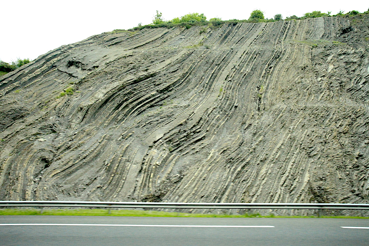
Note the upturned strata on the island. This reflects uplift of the Pyrenees Mountains whose main mass is located east of here. However, the entire region was caught up in the uplift event.

The Pyrenees have had multiple deformation episodes but the latest one was the Alpine Orogeny that created the Alps.

The road cuts near here are spectacular.

Barritz, France

I signed on for a day tour across the border in southern France and loved it.

A map of Spain and Portugal to show these locations. Note the towns of Bilbao and San Sebastian on the north coast of Spain near the French border. Just across the border is the village of Biarritz. Note also that this is the place where the orientation of the shoreline shifts from east-west to north-south. Biarritz is located right there.

This is looking from the area of the lighthouse to the east where rocks from the Pyrenees uplift are located.

Turning 90 degrees right note only a flat sandy coast. This is where the elbow of the Bay of Biscay is located. No mountains looking in this direction all the way to Normandy. This is a former plate junction where the Iberian microcontinent collided with Europe (France).

View if the lighthouse from the center of town.

In Biarritz I visited the market.

France hams for sale. I would have loved to taste it.

The fruit stall.

Fresh fish from the Bay of Biscay. Look how nicely they are displayed. This was one of the cleanest markets I have ever seen.

Visiting the Virgin Mary statue on the bay. Note the tilted sedimentary rocks.

View to the west toward San Sebastian. Our day trip to France was excellent! And our stop in Spain was great too. On to Portugal!

The Coa Valley, Portugal

Our jet took a short flight to Porto in Portugal and we drove 90 minutes to the Douro Valley. The Douro River is a major waterway in northern Iberia. For the Douro Valley, I partook in a day trip to an archaeological site in the Coa Valley.

Through the wine growing region of northern Portugal. It is very scenic. I was very eager to see the Coa Valley because it is the site of a Paleolithic rock art site. The rock art here is between 25,000 and 10,000 years old. Many people have heard of the famous cave paintings in France and Spain and this site is partially equivalent in age.

The Douro River Valley where the Coa River meets this river. Note the river cruise boat.

The museum at the site had perfect recreations of the art as well as excellent exhibits. This is a recreation piece of one of the more famous elements. It is a depiction of a horse with seemingly two heads, one looking each way. But the archaeologists believe the artists were trying to depict motion.

The archaeological site has an interesting story. In 1991 a dam was set to be built on the Coa River shown here. As part of the pre-construction archaeological survey, they found the Paleolithic rock art. The energy company tried to find that the art was not of that age but it was futile. A national campaign was begun and by 1995 the dam project was halted forever. The dam site can be seen on the left side of this photo. What a great story. Read more about it here.

The way in was on dirt roads. The site is limited to about 50 people per day and there were 15 guests in our group.

The last town before the site is Castillo Melhor and the local restaurant is in on the theme.

A larger view of the site with the big floodplain bar likely the site where the artists camped. To think of Homo sapiens living here 25,000 years ago in the height of the Ice Age is thrilling to me.

The first panel being explained by our archaeology guide Antonio Barata. He has worked with rock art at this site since the days of dam construction.

When we arrived the panel was in the shade. But within 10 minutes the sun had drawn high snout to illuminate the elements. Many elements overlap one another and irregularities in the rock are sometimes used for eyes, noses, and other features.

This is a depiction of a horse on the left facing right. There are three heads on the torso which is very evident on the left. Antonio believes that the artists were depicting motion as the horse was grazing with its head down (easily seen at center), then lifting its head in two other positions above that.

Antonio pointing out the site.

A fabulous rendition of an aurochs, a wild predecessor of domesticated cattle. The last aurochs died in Poland in 1837.

More elements on the rock. Our group was ecstatic to see such ancient art.

Look at this! The rock type is schist.

Thank you for reading about my trip - Kingdoms and Cultures of Eurasia!