Most visitors to Mesa Verde National Park go there to see the spectacular cliff dwellings that are preserved in the sandstone alcoves. But these sandstones and the entire landscape tell an interesting geologic story as well. It may be a stretch to say that if there were no cliff dwellings on Mesa Verde that visitors would still go there. But the view from the top of the mesa is world-class and a little knowledge of the rocks brings another learning dimension to the locality. In July of this year I made a geologic excursion to the park with colleague Jack Share.
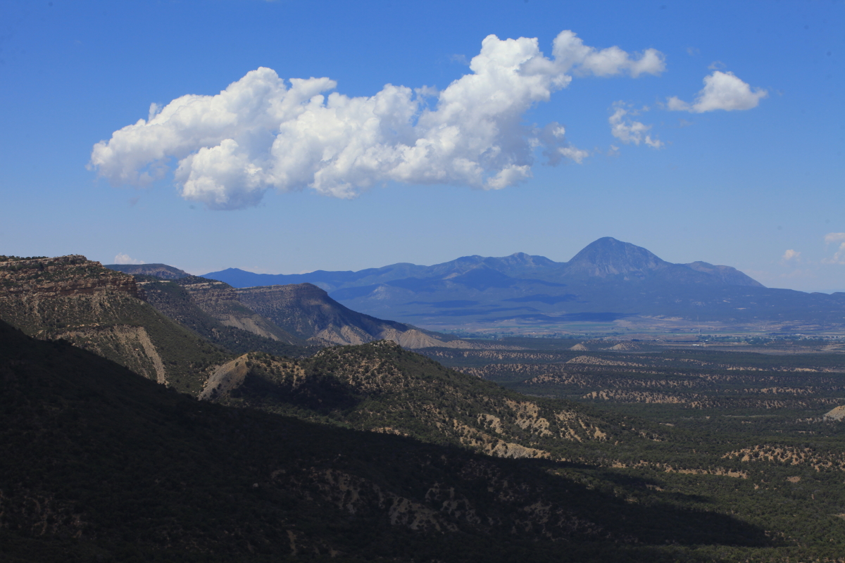
View to the west of the north side of Mesa Verde, which looms high above the Montezuma Valley in southwest Colorado. The great Aztec ruler Moctezuma (whose name was later corrupted to Montezuma) never came this far north but early American settlers attributed the nearby ruins to his dynasty in Meso-America (Mexico). When the Anasazi (or Ancestral Puebloans if you like) lived here in the 13th century AD, there were over 40,000 inhabitants of the Montezuma Valley, more than twice the current population of Cortez, Colorado.
The north flank of the mesa is carved into south-dipping sediments that are of Cretaceous age. As rocks fall off of the edge of this escarpment, it retreats slowly through time to the south (towards the left in this view). That means that these layers once extended up slope farther to the north (to the right) and onto the southern flank of the San Juan dome, a Laramide-age uplift present in southwest Colorado. The rate of retreat on this escarpment can likely be figured out using rates from nearby areas on the Colorado Plateau and may be on the order of about one meter every 2,000 years.
Beyond Mesa Verde to the west is the Sleeping Ute Mountain, a laccolith about 28 million years old. See my previous post on laccoliths in this area here.
Here is a view off of the edge of Mesa Verde to the north. There is a pre-existing topography on top of the mesa that is now being destroyed by the southward retreat of the escarpment. Old drainages that flow down the slope of the mesa are thus being beheaded by scarp retreat. Look beyond the top of the cloud shadow and notice a canyon cut into the top of the mesa. This is Morefield Canyon.
This part of the escarpment is called The Knife Edge and was a prominent feature early in the history of the park as the main road to the ruins was built on the slope beneath it. The road had to be relocated because of the manner in which the Mancos Shale sloughs off in the process of cliff retreat (boulders from The Knife Edge were a constant hazard on the road as well). Note the headwall of Morefield Canyon just visible in the gap in The Knife Edge. The shadowed cliff is carved in the Point Lookout Sandstone, the lowermost unit in the Mesa Verde Group. The Point Lookout Sandstone is a regressive sand, meaning that as the Mancos Seaway was retreating to the east, it left behind these beach sands about 85 million years ago.
Farther along the road is a road cut into the next formation in the Mesa Verde Group, the Menefee Formation. Here Jack explores some of the talus that has come off the cut. The Menefee is a continental stream and swamp deposit that was laid down in a setting much like the present-day Great Dismal Swamp in Virginia or the Okefenokee Swamp in Georgia. Rivers delivered sand to the landscape but these in turn were buried by thick mats of vegetation in swamp environments.
The angled beds of sandstone here are likely point bar deposits from a stream meandering on a coastal plain, some 82 million years ago. As the Cretaceous Seaway retreated to the east, it exposed a low-lying plain that was coursed by many rivers. A map of Menefee time is provided two images down. The black layers are coal seams within the Menefee Formation.
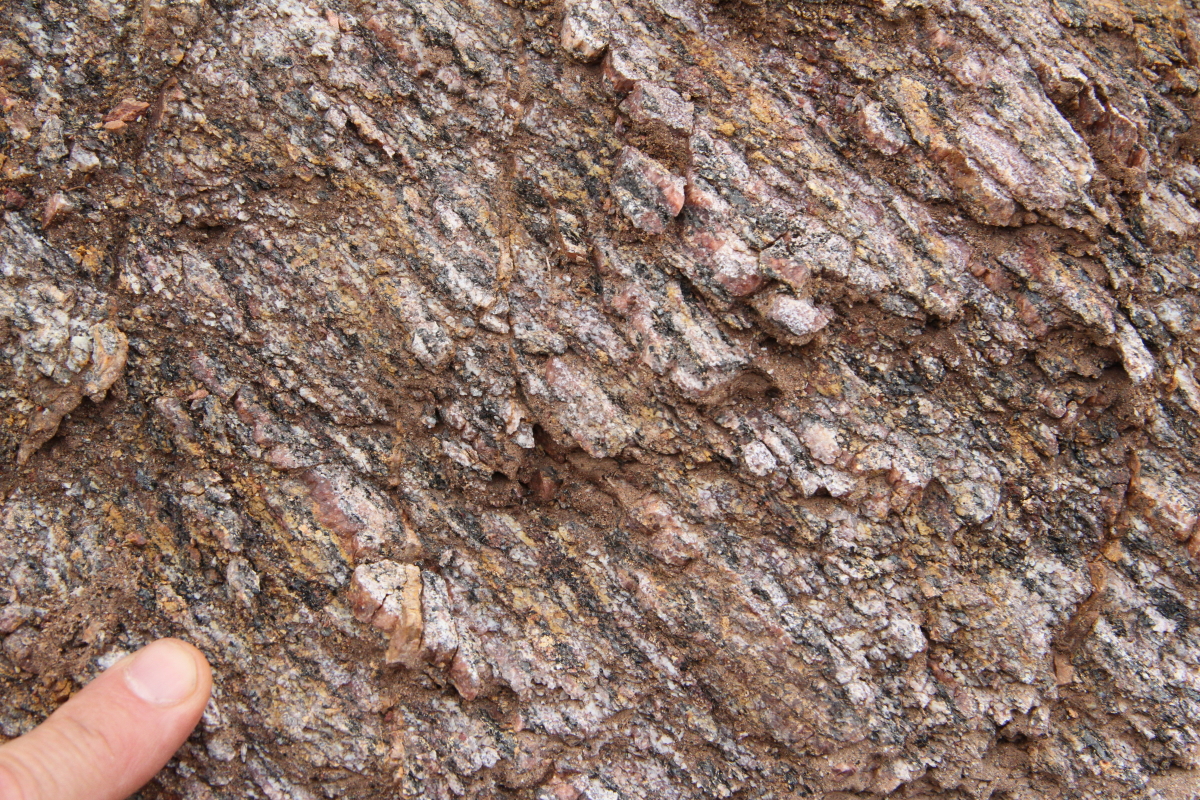
A close-up of a coal seam with plant fragments within it. Palms and conifers are common leaves found in the Menefee, as well as petrified tree trunks. Fossils such as these help determine the environment of deposition.
Paleogeography of the seven southwestern states about 82 million years ago during deposition of the Menefee Formation. Note that the Mesa Verde area in southwest Colorado is the site of a coastal plain adjacent to the Cretaceous Seaway. Map courtesy of Dr. Ron Blakey, Colorado Plateau Geosystems. You can order a CD of these maps from CPG here or purchase a copy of our book, "Ancient Landscapes of the Colorado Plateau" here.
This map looks quite similar to the previous one - except when we zero in on the Mesa Verde region and notice that the seaway has transgressed over the area during a two million year interval. This map displays the geography of the area at about 80 million years ago and introduces the final deposit of the Mesa Verde Group, the Cliff House Formation.
A view of Spruce Tree House in Mesa Verde National Park. The inhabitants used local blocks of the Cliff House Formation to construct these dwellings. The Cliff House represents deposition as the Cretaceous Seaway crept back over the Mesa Verde area about 80 million years ago.
Square Tower House always delights visitors with its four story tower and symmetric preservation. Note the desert tapestries that streak the inside walls of the alcove. These form wherever water preferentially drips from above, allowing for the growth of desert varnish.
The largest cliff dwelling in the US is Cliff Palace with more than 250 rooms. It was an ideal location to build a small village as it receives much winter sun and summer shade. It is built within one of the larger and most well-developed alcoves in MVNP. The alcoves form within the Cliff House Formation, which consists of two massive sandstone bodies separated by a softer sandy shale. This alcove formed at the contact of the upper sandstone and the sandy shale horizon. It was here that groundwater pooled and dissolved the cement in the upper sandstone long before the canyons were cut. Upon exposure the weakened sandstone disintegrates progressively to form the alcove.
A close-up view of the heart of Cliff Palace ruin with a park ranger and lone visitor for scale on the far right. This is reportedly the very first ruin that was glimpsed by Richard Weatherill and Charlie Mason in December, 1888 and is what led to the "discovery" of this entire ruin complex.
Jack and I took the walking tour into Balcony House, my favorite excursion at Mesa Verde. The walk includes an ascent of a double-wide, thirty-two step ladder into the ruin.
Manos (hand-held grinding stones) and metates (grindiing surfaces) lay upon the "frozen" ripple marks of the Cretaceous shoreline. Certainly these people must have wondered about the lithified ripples that are so clearly exposed on the floor of Balcony House........
......especially with such detail of preservation! These are exposed in another ruin site located on Long Mesa. They look as if a foot print today could be made in soft sand. The ripple marks are symmetrical meaning that they likely formed in the broad swath of tide zone, rather than on a river floodplain. The water in a tidal zone is bi-directional and the ripples then become symmetrical in cross-section. In a river, the water is uni-directional and the ripples are formed asymmetrically.
Looking up Soda Canyon to the northeast from Balcony House ruin. The character of the Cliff House Formation changes in this direction with many more shale beds becoming common within the two massive sandstones. This records the deepening of the seawater in that direction during this time. Changes in rock type along the same horizon are known as facies changes.
Mesa Verde is an archaeologists paradise but another fascinating aspect of a visit here lies in its geologic story. What geologic thinking provides us is a way to shift time scales instantaneously - such as when we see a 1,000 year old metate laying on top of 80 million year old ripple marks. Time travel is something I enjoy very much and sharing with others is also appealing to me.
Adventure and foreign travel, philosophical and scientific musings, geology and landscapes, photography and earthly explorations.
Tuesday, September 11, 2012
Monday, September 03, 2012
"Carving Grand Canyon" 2nd Edition Is Here!
The fully updated and revised 2nd edition of "Carving Grand Canyon" is now available for sale. If you would like to order a personally signed copy of the latest theories on how the Grand Canyon may have formed, please send $20 (postpaid) to me here in Flagstaff. My full address is located on my web site. Look under the "Contact Wayne" link. If a signed copy is not important to you, you can order a copy directly from the publisher (Grand Canyon Association) here.
"Carving Grand Canyon" was first published in 2005 and has sold over 27,000 copies in its seven year run.It is the winner of five distinct awards including Honorable Mention in the 2006 National Outdoor Book Awards (in the Nature and the Environment category). 1st Place went to David Attenborough that year. "CGC" was voted Best Science Book in Arizona by the Arizona Book Publishers Association in 2007.
Here are a few excerpts from the new edition.
The Title Page features a striking image of the canyon from Yaki Point looking west at sunset. The image was taken by photographer George H.H. Huey. "CGC" 2nd edition features over 90 photographs by many well-known southwestern photographers. I have 22 of my own photographs as well.
A sample Chapter Opening page. Like its predecessor, "CGC" has five main chapters entitled, The Enigma of Grand Canyon; The Physical Setting; How Rivers Carve Canyons (shown above); History of Geologic Ideas; and Landscape Evolution of the Grand Canyon Region. This edition features an all new Foreword written by Stephen J. Pyne; a Preface and Introduction; and an Epilogue that ties it all together. Also included is a glossary, index and a scientific bibliography to peruse original works of research.
Many new sidebars have been crafted to help illuminate subjects related to the formation of the Grand Canyon. A total of eleven sidebars grace the book. The graphics were drawn by Bronze Black who is fast becoming one of the most widely recognized and respected graphic artists in the Southwest. Here in this sample is his rendition for how segments of the Farallon plate may have been subducted beneath the edge of North America.
A sample page of the text accompanied by two photographs. If you live in Arizona or the surrounding area, please note that my lecture schedule will include the following:
October 3 - Pueblo Grand Museum, Phoenix, Arizona 7 PM; Sponsored by the AZ Humanities Council
November 11 - Prescott Public Library, Prescott, Arizona 2 PM; Grand Canyon Association
November 15 - Northern Arizona University, Flagstaff, Arizona 7 PM; Grand Canyon Association
November 19 - Payson Public Library, Payson, Arizona 10:30 AM; AZ Humanities Council
December 5 - Prescott Public Library, Prescott, Arizona 2 PM; Prescott Geology Club
December 11 - The Heard Museum, Phoenix, Arizona 1:30 PM; AZ Humanities Council
December 12 - Carl Hayden Visitor Center, Page, Arizona 7 PM; Glen Canyon National Recreation Area
March 19, 2013 - Lake Havasu Museum, Lake Havasu, Arizona 7 PM; AZ Humanities Council
March 28, 2013 - Desert Caballero Museum, Wickenburg, Arizona 12 noon; AZ Humanities Council
March 30, 2013 - Tohono Chul Park, Tucson, Arizona 10:30 AM; AZ Humanities Council
Thursday, August 30, 2012
Small Rockfall at Grand Canyon Witnessed by Grand Canyon Sememster Students
This semester at Northern Arizona University, I will teach an Honors class (HON 343) as part of a program called Grand Canyon Semester. Thirteen students from around the US have arrived on campus and will undertake an intensive 16-week course focused on science and issues relating to the Grand Canyon region.
During their Orientation Week, they camped at the South Rim for four nights. I led them on a hike down the South Kaibab Trail to introduce them to some aspects of the geology of the canyon. On Thursday, August 23, storm clouds began to develop as they listened to a talk at Hopi Point. A few claps of thunder could be heard away in the distance. Then, one was heard that just kept rumbling and rumbling and never stopped. The students quickly looked into the canyon and saw a large billow of red dust and rock floating up from the south side of Shiva Temple. A rockfall was underway! This image was captured by NPS ranger Jacob Fillion.
The rockfall appears to have initiated in the upper portions of the Redwall Limestone, deposited during the Mississippian time period about 340 Ma (million years ago). Although the amount of material likely let loose in this fall would dwarf anything human, it is quite small compared to the overall dimensions of the canyon. Notice that evidence for other recent rockfalls is absent in this view and in most views of the Grand Canyon. It is likely that the canyon is not currently experiencing active widening or deepening in modern times and that it may undergo periods where it just sits there with nothing much happening. It is similar in many ways to the biological concept of punctuated equilibrium, whereby species undergo long periods of stasis interspersed with shorter periods of rapid change. Grand Canyon may also undergo a sort of punctuated equilibrium with regard to its formation. The agents that produce the punctuations in this case would be climate change, runoff amount in the river and uplift of the rocks. These are what initiate canyon cutting and widening.
In any event, the fact that our students got to experience a brief moment of canyon widening bodes well for their semester here in northern Arizona. We wish them well on their journey of discovery!
The plume of dust and rock captured in this image is nearly 1,000 feet high from bottom to top. Compared to the overall dimensions of the canyon, this is likely a rather small event with a "flake" of rock only being dislodged. Yet anything directly below the fall having experienced a rather traumatic and violent crushing by the material that was let loose. The canyon challenges us to see our world on many different scales with respect to time and space, large and small. We are moved by its immense size and the lessons in earth history it provides to us.
During their Orientation Week, they camped at the South Rim for four nights. I led them on a hike down the South Kaibab Trail to introduce them to some aspects of the geology of the canyon. On Thursday, August 23, storm clouds began to develop as they listened to a talk at Hopi Point. A few claps of thunder could be heard away in the distance. Then, one was heard that just kept rumbling and rumbling and never stopped. The students quickly looked into the canyon and saw a large billow of red dust and rock floating up from the south side of Shiva Temple. A rockfall was underway! This image was captured by NPS ranger Jacob Fillion.
The rockfall appears to have initiated in the upper portions of the Redwall Limestone, deposited during the Mississippian time period about 340 Ma (million years ago). Although the amount of material likely let loose in this fall would dwarf anything human, it is quite small compared to the overall dimensions of the canyon. Notice that evidence for other recent rockfalls is absent in this view and in most views of the Grand Canyon. It is likely that the canyon is not currently experiencing active widening or deepening in modern times and that it may undergo periods where it just sits there with nothing much happening. It is similar in many ways to the biological concept of punctuated equilibrium, whereby species undergo long periods of stasis interspersed with shorter periods of rapid change. Grand Canyon may also undergo a sort of punctuated equilibrium with regard to its formation. The agents that produce the punctuations in this case would be climate change, runoff amount in the river and uplift of the rocks. These are what initiate canyon cutting and widening.
In any event, the fact that our students got to experience a brief moment of canyon widening bodes well for their semester here in northern Arizona. We wish them well on their journey of discovery!
![]() |
Photo courtesy of Jacob Fillion, NPS |
Monday, August 20, 2012
Colorado's Royal Gorge and the Shelf Road
In July, I traveled to some places in central Colorado that I had never been to before. Here is an account of my trip to the Royal Gorge of the Arkansas River and a scenic geologic drive north of Canon City called the Shelf Road.
This was the second place Jack and I visited that is in the footsteps of Lt. Zebulon Pike (see the previous posting of an account to the Great Sands Dunes National Park). Pike was the first American to see the Royal Gorge of the Arkansas. I wonder why this expedition is not as famous as the Lewis and Clark expedition farther north? His orders were to do the same - explore the new boundary of the United States after the Louisiana Purchase. Hmm?
This is the bridge over the Arkansas River looking to the north. It has wooden planks on it so it rattles quite a bit when a vehicle drives over it.
The bridge over the gorge and the land surrounding it is owned by the municipality of Canon City (prounounced as both cannon and canyon). They operate the area as a kind of amusement park replete with all kinds of American kitsch, clowns, magic shows, and sky rides. A bit disheartening to see so much fluff in an otherwise fantastic landform.
For me the big attraction was the gorge itself. Here is a view to the northwest and the land beyond the gorge. This is a spectacular landform worthy of a visit but we did not find even one sign relating to the natural history of the area. A shame really and it explains why people like myself usually avoid visiting the area. In fact, as I thought about it, I know of very few people who have been here.
Here is one of the sky rides crossing the gorge
And a view of the Arkansas River below with the railroad tracks paralleling the river on river left. The story of how this fantastic rail line was built is told in a book called, "Rival Rails" by Walter R. Borneman. You can read about that book here. I found it to be a fascinating story as the ATSF and the DRG vied for rights to build through the gorge. The DRG eventually won that battle.
A view of the Royal Gorge in the upstream direction with the river and tracks at the bottom. At its deepest point the gorge is 1,250 feet deep. The rather flat surface on top of the gorge is curious. Perhaps this is an erosion surface from the Laramide (approximately 70 million years ago) or it could be a surface formed in the Precambrian that elsewhere in the west is called the Great Unconformity. For a fantastic and comprehensive explanation of the Great Unconformity, see a blog post by Jack Share here.
You can easily see the sheer depth of the gorge in this view. The rock is called the Pike's Peak Granite, although there are places where gneiss and other metamorphic rocks are also present. Formed just over 1,000 million years ago, the granite is an interesting rock to behold (see below).
A laerger view of the lip of the canyon and the Pike's Peak Granite
Close-up of river and railroad
The Pike's Peak Granite up close. A granite with crystals this large is technically called a pegmatite and these form when water in a magma facilitates the growth of large crystals.
A large felspar crystal in the granite can be seen, as well as the perthitic texture within it (lines)
After leaving the Royal Gorge, we entered Canon City and then headed north on a dirt road towards Cripple Creek. We soon found that this road followed Four Mile Creek which brought us to the Garden Park Fossil Area. It was here that the famous "Bone Wars" of the 1870's was played out as paleontologists Edward Cope and Othniel Marsh battled each other for the most significant dinosaur find. Read about it here.
We hiked a short distance to one of the old time quarries, set above the cliff in the red sediments. Note the obvious channel feature within the Morrison Formation at this locality. The dinosaurs would have found the riparian environments that coursed through this area to their liking. For a map of the Morrison paleogeography, see the map below from my book, "Ancient Landscapes of the Colorado Plateau".
Paleogeographic map of the Morrison Formation, Brushy Basin Member
The Shelf Road continues north. We had heard that the road was quite narrow and not to be taken in wet weather (it was wet). However, we found it to be no problem and continued onward.
There was an excellent exposure of the Great Unconformity in the canyon. In fact, the "shelf" of the Shelf Road was built utilizing the contact between the Ordovician Manitou Formation (upper strata) and the Precambrian crystalline rocks below. I had never before seen the unconformtiy as expressed in Ordovician rocks as Arizona has absolutely none of this age.
View of the Shelf Road and its rocks
Jack touching the unconformity at a road cut along the Shelf Road.
Nice photo of the unconformity with a dike trending vertically through the crystalline rocks.
Foliated and very friable schist in the Precembrian rocks along the Shelf Road
As we neared Cripple Creek, we found that we were entering one of the West's great Gold belts. The nearby town on Victor still has a working gold mine.
This was the second place Jack and I visited that is in the footsteps of Lt. Zebulon Pike (see the previous posting of an account to the Great Sands Dunes National Park). Pike was the first American to see the Royal Gorge of the Arkansas. I wonder why this expedition is not as famous as the Lewis and Clark expedition farther north? His orders were to do the same - explore the new boundary of the United States after the Louisiana Purchase. Hmm?
This is the bridge over the Arkansas River looking to the north. It has wooden planks on it so it rattles quite a bit when a vehicle drives over it.
The bridge over the gorge and the land surrounding it is owned by the municipality of Canon City (prounounced as both cannon and canyon). They operate the area as a kind of amusement park replete with all kinds of American kitsch, clowns, magic shows, and sky rides. A bit disheartening to see so much fluff in an otherwise fantastic landform.
For me the big attraction was the gorge itself. Here is a view to the northwest and the land beyond the gorge. This is a spectacular landform worthy of a visit but we did not find even one sign relating to the natural history of the area. A shame really and it explains why people like myself usually avoid visiting the area. In fact, as I thought about it, I know of very few people who have been here.
Here is one of the sky rides crossing the gorge
A view of the Royal Gorge in the upstream direction with the river and tracks at the bottom. At its deepest point the gorge is 1,250 feet deep. The rather flat surface on top of the gorge is curious. Perhaps this is an erosion surface from the Laramide (approximately 70 million years ago) or it could be a surface formed in the Precambrian that elsewhere in the west is called the Great Unconformity. For a fantastic and comprehensive explanation of the Great Unconformity, see a blog post by Jack Share here.
You can easily see the sheer depth of the gorge in this view. The rock is called the Pike's Peak Granite, although there are places where gneiss and other metamorphic rocks are also present. Formed just over 1,000 million years ago, the granite is an interesting rock to behold (see below).
A laerger view of the lip of the canyon and the Pike's Peak Granite
Close-up of river and railroad
The Pike's Peak Granite up close. A granite with crystals this large is technically called a pegmatite and these form when water in a magma facilitates the growth of large crystals.
A large felspar crystal in the granite can be seen, as well as the perthitic texture within it (lines)
After leaving the Royal Gorge, we entered Canon City and then headed north on a dirt road towards Cripple Creek. We soon found that this road followed Four Mile Creek which brought us to the Garden Park Fossil Area. It was here that the famous "Bone Wars" of the 1870's was played out as paleontologists Edward Cope and Othniel Marsh battled each other for the most significant dinosaur find. Read about it here.
We hiked a short distance to one of the old time quarries, set above the cliff in the red sediments. Note the obvious channel feature within the Morrison Formation at this locality. The dinosaurs would have found the riparian environments that coursed through this area to their liking. For a map of the Morrison paleogeography, see the map below from my book, "Ancient Landscapes of the Colorado Plateau".
Paleogeographic map of the Morrison Formation, Brushy Basin Member
The Shelf Road continues north. We had heard that the road was quite narrow and not to be taken in wet weather (it was wet). However, we found it to be no problem and continued onward.
There was an excellent exposure of the Great Unconformity in the canyon. In fact, the "shelf" of the Shelf Road was built utilizing the contact between the Ordovician Manitou Formation (upper strata) and the Precambrian crystalline rocks below. I had never before seen the unconformtiy as expressed in Ordovician rocks as Arizona has absolutely none of this age.
View of the Shelf Road and its rocks
Jack touching the unconformity at a road cut along the Shelf Road.
Nice photo of the unconformity with a dike trending vertically through the crystalline rocks.
Foliated and very friable schist in the Precembrian rocks along the Shelf Road
As we neared Cripple Creek, we found that we were entering one of the West's great Gold belts. The nearby town on Victor still has a working gold mine.
Sunday, August 12, 2012
More Colorado Geology - Great Sand Dunes National Park
One of the hidden geologic gems located just east of the Colorado Plateau and the Rio Grande Rift is the Great Sand Dunes National Park and Preserve. In July, I approached this interesting area with colleague Jack Share while traveling from Durango, to the Continental Divide at Wolf Creek Pass, and across the Alamosa Valley located in the floor of the rift. It is a beautiful and interesting place.
The Sangre de Cristo Mountains loom behind the dunes. This view is to the northeast and behind us to the southeast, the range terminates at Blanca Peak, elevation 14,345. It is only 50 feet lower than Mt. Whitney in the Sierra Nevada and is the third highest peak in Colorado. We could not photograph Blanca Peak because it was perpetually in clouds.
On the approach we could see the dunes had been recently drenched in rain.This was the time in July when the Rocky Mountain front range was ablaze with fire and these are the rains that quenched the blazes.
Sunset in the Sangre de Cristo Mountains, July 8. The low angle light on the feldspar-rich granites are what gave the mountains their name (blood of Christ).
Sunrise on the dunes, July 9
We took a walk up the dunes to observe modern eolian processes. Here is a trackway of an insect that has been active the night before.
Some areas of the dunes had a blackish tinge and closer inspection showed that this was due to iron-rich minerals being winnowed from the quartz sand into discreet pockets. Density differences between these two mineral types causes this winnowing, much the same as gold-panning will winnow gold to the edge of the pan. It is the inclusion of these iron-rich minerals in the white quartz sand that could eventually turn this future sandstone red - when the whole package is buried, groundwater can infiltrate the sand and dissolve the iron component, whose solutions then coat each sand grain with a red coating.
The iron-rich minerals are derived from the granites in the Sangre de Cristo Mountains. But they do not simply travel from the mountain front to the dunes. First they must be washed to the west into the Alamosa Valley, where huge piles of sediment have filled the Rio Grande Rift. During the Ice Age, this valley contained Lake Alamosa, which would repeated fill and dry out. Then the wind picked up the dried sediment as sand and blew it to the east where it encountered the high range causing the wind to slow down and dump its load of sand here. What a journey the sand makes!
The recent rains made walking easier for us
And the vistas were superb. We both felt as if we were walking in some Jurassic dune field on the Colorado Plateau (although those dunes were much more Sahara-like and not so Alpine.
Low-angle light easily differentiates the windward and leeward sides of these wind ripples - the wind in this instance is blowing towards the person
The sand is trying to climb up into the range but this is about as far as it gets. Zebulon Pike came through this area in January, 1806 while surveying the new international boundary between the United States (Louisiana Purchase) and New Spain.
Looking north across the dunes to the northernmost part of the Sangre de Cristo range
As we left the park, we could see that another day of rain was building up
In a nine-day trip across southern and central Colorado, this was the biggest surprise (out of many). Here, the iron-rich grains are easily highlighted in the dunes.
Subscribe to:
Posts (Atom)