Saturday, November 19, 2011

A Geology Field Trip to Grand Canyon - Toroweap Overlook and Vulcan's Throne

Over Halloween this year, I embarked on a five-day field trip with many of my former geology students from Yavapai College in Prescott. I've been semi-retired from formal teaching for a few years now but the magic of geology just doesn't seem to wane for these die-hards. I love it! They choose a location and off we go. This posting is written by me but with illustrations from Bruce, Carol, and Mary Lea. I asked the class for photo's to show off what we saw and learned here. You can also view some of my photo's and narrative here from a trip I took in April.

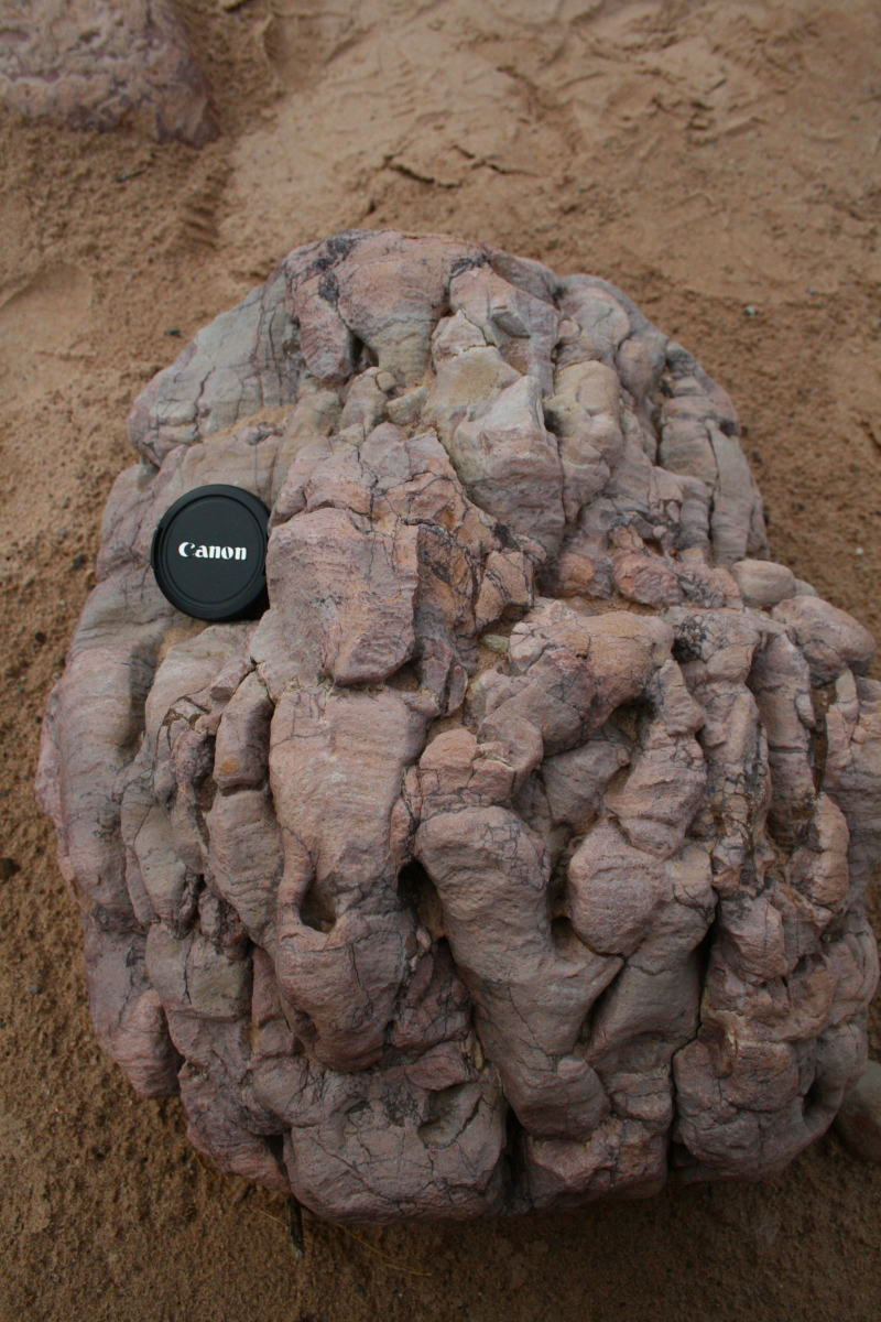
The trip began with an overnight stop at Lees Ferry on the Colorado River. We meant to hike down Cathedral Wash but a recent storm had filled mudholes along that creek making it impassible. So, off to the hoodoos and here I am pointing out the amount of "deflation" on the landscape since this Shinarump boulder rolled down from the cliff above. The boulder is a conglomerate rock from this member of the Chinle Formation. The pedestal below is carved into the underlying Moenkopi Fm. This deflation is probably on the order of a few tens of thousands of years in length (just an educated guess). These features are found everywhere along the base of the Vermilion Cliffs and you can see two other large boulders in the background awaiting more defaltion so that they can have their pictures taken.

We finally arrived at the edge of the canyon and this is one of the viewpoints looking east. Many images from this place have been featured in mainstream advertising in recent years.

Contemplating the Grand Canyon. What a marvelous place.

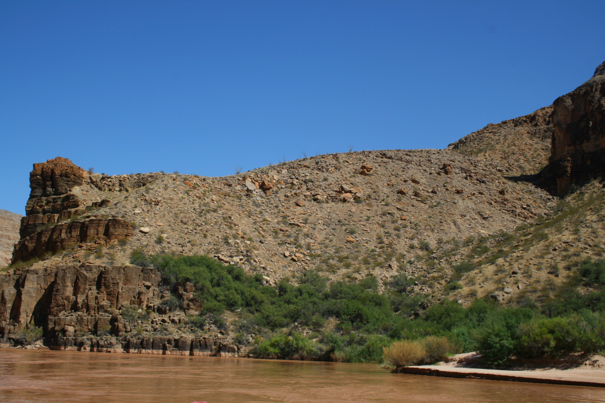
At the main overlook we got a great view across the Colorado River into Prospect Valley. The lighting here does not easily show it, but this was once a deep side canyon that became filled with lava. The shadowed, inverted V canyon is what has been re-excavated since the lava filled the old canyon. On the left side of the photo but not as obvious is the Toroweap fault. It lies at the base of the scarp across the river to the left hand side of the photo. The vast majority of the Esplanade surface in the center of the photo is down dropped about 500 feet here.

Students on the edge of Grand Canyon looking into Lava Falls. Note the cross-bedding in the Esplanade Sandstone here.

One of the days, we hiked from camp over the sandstone ridge to Vulcan's Throne. There are few things as wonderful as walking on slickrock in the southwest.

Ken is checking to see if we have arrived at the top of this 500-foot tall cinder cone and his calculations verified that we ran out of volcano and were at the end of the hike. Actually, he is looking in the trail register located in a cairn on top of the feature.

What are the chances that a cinder cone would have erupted at the edge of the Esplanade over the Colorado River? This has got to be one of the most spectacular settings for a volcano - on the lip of a 3,000 foot gorge.

Pointing out the trace of the Toroweap fault across the Colorado River.

A group shot from the top of Vulcan's Throne. Note the wide, Toroweap Valley in the left background. This was also once the site of a big side canyon in Grand Canyon but was filled with numerous lava flows from the Uinkaret Volcanic Field. Recent offset on the Toroweap fault interrupted a small drainage on the north side of Vulcan's Throne and caused a playa lake to form just beyond and below the group. There is so much to see and learn here.
Back at camp, it was time for the Halloween celebration and here you see my very first pumpkin carved.

A basalt boulder with many native petroglyphs etched into it.

One last shot before leaving the Toroweap area. From left to right - Sharon, Clint, Ken, Louise, Mary Lea, Brenda, Carol, Bruce, Chris, Wayne, Barbara, Russ, Alice, George, and Dennis. Great folks - one and all.

Sunset from Toroweap Overlook.

Brenda wrote poem about our trip here:

-->
Toroweap Time Shared by Brenda

"River's high,"
Sinyala sighs,
while Lava Falls'
 sirens call
"Come close."
From his cinder throne
Vulcan moans
"Where's the fire?"
Two-toothed Jack with Buddha smile
knows where embers glow and
shine magic 

on this hallowed night
   
Chris too:

-->
Although too old to do some treks,
You are never too ancient to attempt
that first Pumpkin.  With skill, you
carved out eyebrows that resembled the
narrow curves of the Colorado.  Again
with competence, you lead our group of
aging Geonuts on another journey.
Adroitly you presented information for all to
digest, no matter how clogged are our skulls.
We observed hot air rising out of the canyon,
with birds capturing the drafts, and occasional
explosions of campfire discussion addressing
inflamed bodily emissions.
A new volcanic hill was scaled and all
groupies are content with another rewarding outing.
Thanks for being there,


and Dennis:


-->
The Professor and the Pumpkin    
 by Dennis Peterson

Our leader, professor Wayne Ranney
can rhapsodize for days on carving
the Grand Canyon,
from Apatites to Xenoliths
but has never carved into a pumpkin.
How can that be?

Well, last Halloween history was made.
George and Carol, the pumpkin providers
for our Toroweap geology trip
during the Halloween celebration
presented the spheroidal object
to Professor Ranney.
Even though it wasn't stratified
or volcanic in origin, he went
at it like the mighty Colorado.

With pen first drawing the face
giving place for the knife to follow
not unlike those early miners
who dug out the Grand Canyon
those many many years ago;

a place to insert their shovels.  The orb now looking like a topo map  and with directions coming from all sides  the first slice was made, erosion by knife.  The face began to take shape, first the eyes, then nose  and lastly the mouth.   Oh schist! a slip of the knife,  a tooth has been mass wasted.  Emergency call to Dr Weld  our groups' staff Dentist.  But how to reattach it?  Forward comes Ken, Dr Welds  able assistant with a toothpick  for the attachment;  now the Grand Toroweap Pumpkin  has its smile restored.  With candle inserted and lit  casting an eerie smile over us  not unlike professor Ranney's  when he stumps the class  with questions like  "who here has ever seen or lit a fart?"  Questions like that, deep thinking  and reflective cause his students  into long and meaningful discussions.  Meanwhile the Grand Toroweap Pumpkin  all lit up and smiling, wondering  what all this talk is about  and what it has to do with geology.  Even though the Grand Toroweap Pumpkin  has an internal flame glowing  and could work very nicely  as a flame thrower,  it's of no use for the topic now discussed  for no thought was given  to hollowing out a fumarole.   With only a carved head and nothing below  the Grand Toroweap Pumpkin can only laugh with us.

Monday, November 14, 2011

Making Phoenix A Green City

An editorial appeared in the New York Times recently that takes a hard look at my home states' struggle to move into the 21st century. I reprint the article here for your perusal. Please note that I will return to my more photogenic blogs later this week with some beautiful pictures taken on my various trips in the fall. And thank you for your support!

The Dark Side of the ‘Green’ City
By ANDREW ROSS
November 6, 2011

The struggle to slow global warming will be won or lost in cities, which emit 80 percent of the world’s greenhouse gases. So “greening” the city is all the rage now. But if policy makers end up focusing only on those who can afford the low-carbon technologies associated with the new environmental conscientiousness, the movement for sustainability may end up exacerbating climate change rather than ameliorating it.

While cities like Portland, Seattle and San Francisco are lauded for sustainability, the challenges faced by Phoenix, a poster child of Sunbelt sprawl, are more typical and more revealing. In 2009, Mayor Phil Gordon announced plans to make Phoenix the “greenest city” in the United States. Eyebrows were raised, and rightly so. According to the state’s leading climatologist, central Arizona is in the “bull’s eye” of climate change, warming up and drying out faster than any other region in the Northern Hemisphere. The Southwest has been on a drought watch 12 years and counting, despite outsized runoff last winter to the upper Colorado River, a major water supply for the subdivisions of the Valley of the Sun.

Across that valley lies 1,000 square miles of low-density tract housing, where few signs of greening are evident. That’s no surprise, given the economic free fall of a region that had been wholly dependent on the homebuilding industry. Property values in parts of metro Phoenix have dropped by 80 percent, and some neighborhoods are close to being declared “beyond recovery.”

In the Arizona Legislature, talk of global warming is verboten and Republican lawmakers can be heard arguing for the positive qualities of greenhouse gases. Most politicians are still praying for another housing boom on the urban fringe; they have no Plan B, least of all a low-carbon one. Mr. Gordon, a Democrat who took office in 2004, has risen to the challenge. But the vast inequalities of the metro area could blunt the impact of his sustainability plans.

Those looking for ecotopia can find pockets of it in the prosperous upland enclaves of Scottsdale, Paradise Valley and North Phoenix. Hybrid vehicles, LEED-certified custom homes with solar roofs and xeriscaped yards, which do not require irrigation, are popular here, and voter support for the preservation of open space runs high. By contrast, South Phoenix is home to 40 percent of the city’s hazardous industrial emissions and America’s dirtiest ZIP code, while the inner-ring Phoenix suburbs, as a legacy of cold-war era industries, suffer from some of the worst groundwater contamination in the nation.

Whereas uptown populations are increasingly sequestered in green showpiece zones, residents in low-lying areas who cannot afford the low-carbon lifestyle are struggling to breathe fresh air or are even trapped in cancer clusters. You can find this pattern in many American cities. The problem is that the carbon savings to be gotten out of this upscale demographic — which represents one in five American adults and is known as Lohas, an acronym for “lifestyles of health and sustainability” — can’t outweigh the commercial neglect of the other 80 percent. If we are to moderate climate change, the green wave has to lift all vessels.

Solar chargers and energy-efficient appliances are fine, but unless technological fixes take into account the needs of low-income residents, they will end up as lifestyle add-ons for the affluent. Phoenix’s fledgling light-rail system should be expanded to serve more diverse neighborhoods, and green jobs should be created in the central city, not the sprawling suburbs. Arizona has some of the best solar exposure in the world, but it allows monopolistic utilities to impose a regressive surcharge on all customers to subsidize roof-panel installation by the well-heeled ones. Instead of green modifications to master-planned communities at the urban fringe, there should be concerted “infill” investment in central city areas now dotted with vacant lots.

In a desert metropolis, the choice between hoarding and sharing has consequences for all residents. Their predecessors — the Hohokam people, irrigation farmers who subsisted for over a thousand years around a vast canal network in the Phoenix Basin — faced a similar test, and ultimately failed. The remnants of Hohokam canals and pit houses are a potent reminder of ecological collapse; no other American city sits atop such an eloquent allegory.

Andrew Ross is a professor of social and cultural analysis at New York University and author of “Bird on Fire: Lessons From the World’s Least Sustainable City.”

Monday, November 07, 2011

The Beginning of the End

Here in the American Southwest, water is king and the scarcity of this commodity is written into the DNA of every living creature. Pack rats process so much water out of their urine that their pee comes out thick as molasses. This enables them to get by on next to no water at all and they obtain most of it from what they eat. They are the ultimate southwestern creatures who laugh at the monthly periods of no rain that we oftentimes experience here.

The pack rats' viscous pee has an unintended consequence - it cements together all of the material inside their nest. This is composed of pieces of dried out cactus, pine needles, juniper berries, Rolex watches, etc. Pack rats only travel about 100 meters away from the nest to obtain all of this material. So even if we couldn't see beyond the nest, if we were a crippled pack rat so to speak, we would know what is growing within 100 meters just by examining the material found within the nest. (Where's that damn Rolex tree?).

It's so dry here that the vegetation held in these cemented nests can last tens of thousands of years in an protected cave. This is how geologists are able to reconstruct what the Ice Age Southwest looked like 15,000, 20,000, even 50,000 years ago. No person was present here to write about or otherwise record what was growing at that time. But the pack rats were recording it for us (by collecting whatever was growing within 100 meters of that ancient nest). What a beautiful science!

Along comes a creature with a big brain and voila! - water storage. Water storage has been the real growth engine for cities in the southwest and without it, Phoenix, San Diego, Los Angeles, and Las Vegas would still be towns of about 75,000 people. Water storage is the Miracle-Gro for Southwestern cities.

But water storage on sediment rich rivers like the Colorado has long term consequences. These consequences were not even considered (if at all recognized) when we decided to tame the Colorado River for water storage in the 1920's. Think about it - the idea to build dams on the Colorado River was hatched before we knew that the Milky Way was not the only galaxy in the universe, and long before we knew that the continents drifted over the surface of the earth.

My point is that the cumulative human knowledge that we possessed when we decided to tame the Colorado was miniscule compared to what we see and know now. Our knowledge of the natural world has increased many times over and our large brains might allow us to reevaluate the decision to dam this river (if political interests weren't so strong). Don't get me wrong - the short term benefits of these dams is still viable and has actually allowed southwestern cities to laugh at the current 12 year drought. Lawns are still green in Arizona and cement driveways are still being washed in southern California.

But what will happen to the Colorado River as all of its sediment continues to pile up behind the dams? Perhaps only a geologist could even begin to frame such a question (although environmentalists were the first to question the rationality of these dams but for other reasons). Only a geologist could think that the 700-year maximum life expectancy of Glen Canyon Dam (with other estimates as low as 250 years) will be here before we know it. Perhaps only a geologist can envision the mess that will be created on a regional scale as these dams fill with sediment. When the sediment absolutely fills the storage body, what will the river water do? What will those cities do for water?

When I bring this topic up with most people, they become noticeably indifferent - it's just too far off in the future for most people. (Our brains also retain a lot of wiring from the Pleistocene that "keep us in the moment"). But the era of tearing down dams has begun already. If you want to see a vision of the future for our southwestern dams (admittedly hundreds of years in the future but reality nonetheless) watch this video of the Condit Dam in Washington state being breached and drained of its sediment.

The future is here now. And what you watch here in this excellent video will happen on the Colorado River one day. This is the ultimate fate of Glen Canyon Dam, Hoover Dam, and every dam ever built on any river. This is the beginning of the end.

You can watch the video here.

Monday, October 24, 2011

Fall Trip to Southeast Utah

I've been out of computer range for the past two weeks but am now back up and running. This past weekend I traveled to a remote place in Southeast Utah where the fall colors were in full glory and we poked around a few great and familiar places.

From our camp, we had a view to the south down into Comb Wash, named after the obvious geologic feature on the left, Comb Ridge. This feature is one of the Colorado Plateau's famous monoclines, a flexure in previously flat-lying strata. This structure was formed during the Laramide Orogeny about 60 million years ago but when the rocks in this view were folded, they were still many thousands of feet in the subsurface. More recent erosion has exposed this view. The cliff-former on the left is the Wingate Sandstone and the valley trailing aware from the camera is cut into soft formations like the Chinle, Moenkopi, and Organ Rock. If the geology doesn't interest you, note the colorful cottonwood trees in the valley floor.

Turning 180 degrees from the photo above reveals a view of the Comb Ridge monocline towards the north. Here you can easily see the flex of the strata, which from left to right are the Cedar Mesa Sandstone (light colored sandstone in upper left), the Organ Rock and Moenkopi formations (directly above and far behind the flat sandstone slab in the center), a very thin ledge of the Shinarump Conglomerate (barely visible), and the Chinle Formation in the upper right.

This is Tower House ruin located near Comb Wash. We hiked to here from camp on our first day in the field. It is a well-preserved ruin that was built atop some interesting deposits. Look just below the obvious window and you'll note a slightly cemented conglomerate. We saw this deposit filling other alcoves nearby. My interpretation was that this wash was dammed by a landslide and that rocky debris accumulated within the alcoves behind a natural reservoir. When the landslide was breached, the streams in this area began to scour out the deposit but remnants were left in the alcoves.

A granary near Tower House ruin. The many ruins that date from the Pueblo II and Pueblo III periods (about 950 to 1300 AD) utilize alcoves for shelter and sun aspect. Passive solar heating (winter) and shade (summer) was well-known to these people.

A petroglyph on the wall at Tower House Ruin. By chipping off the slightly darkened and varnished surface on the outside of the rock, a lighter image can be seen.

On day two we drove to the north and explored an area known as Whiskers Draw, where aspens were growing on the valley floor.

Hiking on slickrock is a favorite past time of mine and here we are angling up to view  more surprises.

A view of an old dwelling that dates from about 1250 AD.

Here is an iside view of the old dwelling with roof beams and latillas.

Hand prints were also evident, both positive (above) and negative (below)

A small ruin perched on ledge near famous Cave 7

A view from the other side of the same house

This is the Cave 7 site. It was here in 1893 that Richard Weatherill came to the understanding that a previous group (before the Puebloans) had lived in these caves. The name of these earlier peoples would become the Basketmakers.

Group shot taken near Comb Ridge with the Abajo Mountains in the background. Left to right Bill Leibfried, John Shortridge, Don Webster, Chuck LaRue, John Grahame, George Abbott, and Wayne Ranney. There are not many things better than having friends like these to go exploring with. And that deserves an exclamation point!

Wednesday, September 21, 2011

My 10-Day Rafting Trip Through Grand Canyon - 2011

This years 10-day rafting trip in Grand Canyon was one of the best ever with an enthusiastic group that was treated to some of the best "earth on show". We had some spectacular weather that was challenging at times but never failed to deliver top notch scenery, waterfalls and comfortable hiking. I still have a few spaces for the trip in 2012. If you've ever wanted to see Grand Canyon with a geologist, check out these pictures from this years trip.

At Lees Ferry, the start of all Grand Canyon river trips, the Kaibab Limestone makes its first appearance above river level (the whitish beds beneath the red Moenkopi Fm.). In just 65 miles it will tower between 5,000 and 6,000 feet above the river. The river drops just 500 feet in this distance but the rocks rise up at an average rate of 70 feet per mile.

The first day on the river with brilliant sunshine

The first appoearance of the Coconino Sandstone above the river at mile 4 below Lees Ferry. The Coconino was deposited as ancient dunes along a shoreline.

 The skies opened up in Marble Canyon and we were witness to the rare treat of red waterfalls!

The pictures cannot capture the sound and smell of this red rain, coming off the upper slopes of Hermit and Supai formations.

 The water poured off the cliffs in great leaps.

 There were literally hundreds of falls within a three mile stretch of the river.

 Our boatmen, Brandon and Amity, admired the show as well.

And then, just as suddenly as it had started, the sun came out to illuminate the recently watered cliff faces.

 From the mouth of Saddle Canyon looking upstream on the Colorado River

Back inside Saddle Canyon - one of my favorite places in all of Grand Canyon

The water this morning was red from the previous days rain

 Can you spot the channel fill of Temple Butte Limestone in the wall of Saddle Canyon? It is shaped like a smiley face and contains Devonian estuary deposits.

The famous "brain rocks" of Carbon Creek Canyon. These are Precambrian age stromatolites or algae fossils. The algae would greow a thin  mat on the shallow sea floor and then sediment would thinly cover the living organism, which then sent more filaments upward to create a new mat. And on and on and on, through time.

A recent flood left behind a strange, black colored deposit on the bed of Carbon Creek that partially buried the vegetation that is growing along the small creek.
.
It was very soft and behaved like quicksand when walked upon. Here Laurie, gets stuck within it.

The famous upturned beds of Tapeats Sandstone along the Butte Fault in Carbon Canyon. Some young earth creationists use this outcrop in an attempt to show that the sediment was not lithified when deformed but other explanations (such as ductile deformation) can also explain this arrangement of strata.

These are the rocks that the stromatolites come from - the Galeros Formation in the Chuar Valley

Storm clouds hover near Papago and Zuni viewpoints on the South Rim, September 14, 2011

Clouds within the canyon on Zoroaster Temple

Close-up of Zoroaster Temple

Riding the river within the Granite Gorge of Grand Canyon

Deformation within the Vishnu Schist revealed in a S-bend to the foliation (giant S-bend is found in the fabric of the rock just above river level.

Morning classroom on the river

The moon setting behind the Great Thumb Mesa in Conquistador Aisle

The warm waterfall in Stone Creek

The patio, a quiet paradise in Deer Creek

A sill of basalt that has intruded into beds of the Bright Angel Shale (lower part of the photograph)

Vulcans Anvil is a volcanic plug or neck that remains as a remnant upstream from Lava Falls on the river
A lava cascade comes into the Grand Canyon from the north side of the river near Whitmore Wash. Imaging what it must have looked like to see red hot lava pouring into the Ice Age river.

Opportunities to see wildlife abound on this trip we saw many Bighorn sheep browsing along the rivers edge
On at least five separate occasions, huge lava dams burst catastrophically into the lower river, leaving behind some pretty fantastic deposits. Here, a former channel of the Colorado River is filled with such debris, which can contain boulders as big as 100 feet in diameter and up to 600 feet above the modern channel. These were huge outburtst floods.

The Black Ledge lava flow as exposed near Mile 208 on the Colorado River. This flow traveled 86 miles down the river and only remnants of it remain after it was erupted 600,000 to 650,000 years ago.

Group shot at Travertine Grotto in the Lower Gorge

A black dike within the igneous rocks of the Lower Gorge

This is the remains of Bridge Canyon City where dam builders were surveying the proposed Bridge Canyon Dam.

A backward glance at the far end of the Grand Canyon where it abruptly ends at the Grand Wash Cliffs.