This years 10-day rafting trip in Grand Canyon was one of the best ever with an enthusiastic group that was treated to some of the best "earth on show". We had some spectacular weather that was challenging at times but never failed to deliver top notch scenery, waterfalls and comfortable hiking. I still have a few spaces for the trip in 2012. If you've ever wanted to see Grand Canyon with a geologist, check out these pictures from this years trip.
At Lees Ferry, the start of all Grand Canyon river trips, the Kaibab Limestone makes its first appearance above river level (the whitish beds beneath the red Moenkopi Fm.). In just 65 miles it will tower between 5,000 and 6,000 feet above the river. The river drops just 500 feet in this distance but the rocks rise up at an average rate of 70 feet per mile.
The first day on the river with brilliant sunshine
The first appoearance of the Coconino Sandstone above the river at mile 4 below Lees Ferry. The Coconino was deposited as ancient dunes along a shoreline.
The skies opened up in Marble Canyon and we were witness to the rare treat of red waterfalls!
The pictures cannot capture the sound and smell of this red rain, coming off the upper slopes of Hermit and Supai formations.
The water poured off the cliffs in great leaps.
There were literally hundreds of falls within a three mile stretch of the river.
Our boatmen, Brandon and Amity, admired the show as well.
And then, just as suddenly as it had started, the sun came out to illuminate the recently watered cliff faces.
From the mouth of Saddle Canyon looking upstream on the Colorado River
Back inside Saddle Canyon - one of my favorite places in all of Grand Canyon
The water this morning was red from the previous days rain
Can you spot the channel fill of Temple Butte Limestone in the wall of Saddle Canyon? It is shaped like a smiley face and contains Devonian estuary deposits.
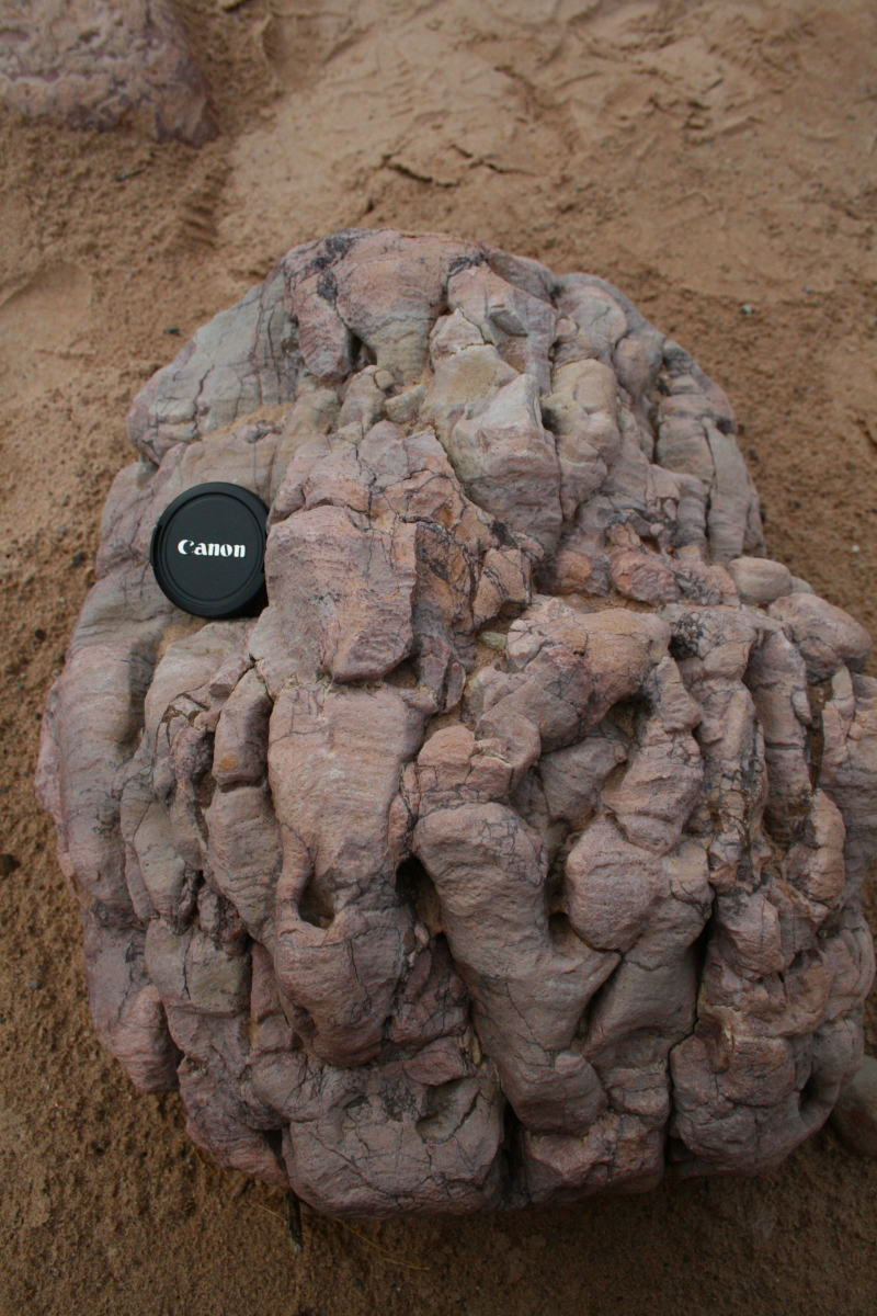
The famous "brain rocks" of Carbon Creek Canyon. These are Precambrian age stromatolites or algae fossils. The algae would greow a thin mat on the shallow sea floor and then sediment would thinly cover the living organism, which then sent more filaments upward to create a new mat. And on and on and on, through time.
A recent flood left behind a strange, black colored deposit on the bed of Carbon Creek that partially buried the vegetation that is growing along the small creek.
.
It was very soft and behaved like quicksand when walked upon. Here Laurie, gets stuck within it.
The famous upturned beds of Tapeats Sandstone along the Butte Fault in Carbon Canyon. Some young earth creationists use this outcrop in an attempt to show that the sediment was not lithified when deformed but other explanations (such as ductile deformation) can also explain this arrangement of strata.
These are the rocks that the stromatolites come from - the Galeros Formation in the Chuar Valley
Storm clouds hover near Papago and Zuni viewpoints on the South Rim, September 14, 2011
Clouds within the canyon on Zoroaster Temple
Close-up of Zoroaster Temple
Riding the river within the Granite Gorge of Grand Canyon
Deformation within the Vishnu Schist revealed in a S-bend to the foliation (giant S-bend is found in the fabric of the rock just above river level.
Morning classroom on the river
The moon setting behind the Great Thumb Mesa in Conquistador Aisle
The warm waterfall in Stone Creek
The patio, a quiet paradise in Deer Creek
A sill of basalt that has intruded into beds of the Bright Angel Shale (lower part of the photograph)
Vulcans Anvil is a volcanic plug or neck that remains as a remnant upstream from Lava Falls on the river
A lava cascade comes into the Grand Canyon from the north side of the river near Whitmore Wash. Imaging what it must have looked like to see red hot lava pouring into the Ice Age river.
Opportunities to see wildlife abound on this trip we saw many Bighorn sheep browsing along the rivers edge
On at least five separate occasions, huge lava dams burst catastrophically into the lower river, leaving behind some pretty fantastic deposits. Here, a former channel of the Colorado River is filled with such debris, which can contain boulders as big as 100 feet in diameter and up to 600 feet above the modern channel. These were huge outburtst floods.
The Black Ledge lava flow as exposed near Mile 208 on the Colorado River. This flow traveled 86 miles down the river and only remnants of it remain after it was erupted 600,000 to 650,000 years ago.
Group shot at Travertine Grotto in the Lower Gorge
A black dike within the igneous rocks of the Lower Gorge
This is the remains of Bridge Canyon City where dam builders were surveying the proposed
Bridge Canyon Dam.
A backward glance at the far end of the Grand Canyon where it abruptly ends at the Grand Wash Cliffs.