Thursday, June 04, 2009

Backpacking in Coyote Gulch, Utah

Imagine getting to go on a backpack to a place you haven't visited for over 32 years. That was my good fortune during the week of May 25 when I led a group of eight friends to Coyote Gulch in the Escalante River country of southeast Utah. The trip was coordinated through the Museum of Northern Arizona's Venture Program. This organization provides quality educational backpacks and van excursions on the Colorado Plateau and it has been my privilege to be a leader for the program since 1982. This was an excellent trip with great travel companions who accompanied me to the Hall's Creek Narrows in May, 2008. Check out the pictures from this lush, southwestern oasis.


Our group starting the seven-mile hike to camp. The Straight Cliffs line the plateau in the background and once extended out over the Escalante country. When rocks peel off their face, the cliff edge recedes slightly and through time the line of cliffs retreats back to the west.

Roman Escamilla, a very strong yet gentle 18-year-old who accompanied his father Eluterio on the trip, examines disrupted strata in the Carmel Formation near the trailhead. Soft-sediment deformation caused this block of siltstone to rotate around in a mass if highly deformed layers. The disruption is most likely due to pressure from the weight of overlying strata.

Entering the narrow in Hurricane Wash, our chosen approach route.

About a mile upstream from Coyote Gulch a spring emerges from the bed of Hurricane Wash. Let the greenery begin!


Our first view of Jacob Hamblin Arch along the course of Coyote Gulch.


And a view from the opposite side of the arch. The creek makes a wide turn around the arch and one day soon (10,000 years?) the creek may remove the last 30 feet of material in the floor of the arch and it will be come a natural bridge through which the creek will flow.


From high above, this was a view of our base camp beneath a large, overhanging alcove. The energy of the stream when in flood continues to eat its way deep into the rock creating these alcoves. Although we camped on the inside bend of the creek, we were well covered by the 400-foot high ceiling that was overhung from the outside bend.

A wide-angle view towards the sky from inside our base camp alcove.


After a restful nights sleep within the womb of red earth, we took a hike the next day downstream to see more wonders. The "trail" wanders repeatedly in and out of the creek.

Coyote Natural Bridge where the stream flows beneath its own creation. A cut-off meander bend was found to the right side of this bridge where we enjoyed lunch.

There was only one place where the trail ascended out of the bed of the creek and that led to this narrow, high neck of land where we gazed in wonder at the huge bend that is entrenched into the Navajo Sandstone.


A beautiful waterfall descends over ledges in the Kayenta Formation. We wewre only about two miles from the Escalante River but the day was getting long and we still had to retrace our steps back to camp.

Beautiful patterns created by the stream in the sand.

Beginning our way out of this watery and rocky paradise.


One night while camped in our cozy alcove, we heard the unmistakable crash of a rockfall somewhere in the canyon. The next day we saw the evidence for it and although it was quite small compared to the size of the canyon, we gingerly scuttled away knowing that the canyon is constantly becoming larger.


I've always wondered what the surface of a 'desert tapestry' looked like and the rockfall allowed us a view of the rather thick mat of lichens and moss that make up these black streaks


A look at a beautiful bend containing the tell-tale signs of a spring - maidenhair ferns.


Our group in Coyote Gulch.

Thursday, May 14, 2009

"Ancient Landscapes" and "Images" Win Awards!

This past Saturday, May 9, I attended the annual Arizona book awards presented by the Arizona Book Publishers Association. The event was held on the top floor of the Chase Tower in downtown Phoenix and was attended by about 80 people. I am happy to report that my books won three first place awards and my publisher, the Grand Canyon Association, won a special award for Excellence in Publishing. Here is the group's web site announcing the awards.

"Ancient Landscapes of the Colorado Plateau," co-authored with Ron Blakey won a Glyph Award in the Science/Environment category. "Images," co-authored with Jack Dykinga and Charles Bowden won two Glyphs in the categories of Nature/Environment and Coffee Table/Large Format. These awards were judged by librarians across the state and book store managers who track interest in new books. The awards are significant because they highlight the interest that people have for readily accessible geologic information.

You can also follow this link to Lee Allison's blog for more information of the awards.

Here are the photo's.

A scene from the awards dinner. From left, Kathryn Conrad and Holly Schaffer, both of the University of Arizona Press, and Gwen Henson, the Executive Director of the Arizona Book Publishers Association.


Here I am with the first Glyph for "Images"


Helen Thompson accepted the award for "Ancient Landscapes" on behalf of the Grand Canyon Association


Wayne and Helen with two of the three trophies


Glyph Awards, 2009

Sunday, May 03, 2009

A Geology Class in the Henry Mountains

During the last week of April, I took 13 students from Coconino Community College on a six-day field trip to the Henry Mountains in Utah (GLG 298). It is a very unique area that is remote, little visited, and full of surprises. We explored the Mt. Hillers stock, the Waterpocket Fold in Capitol Reef, some nearby slot canyons, and other geo-gems along the way. Take a look.  


Here we are, the 14 of us outside the Mt. Hillers stock for a group shot. We are seated on an upturned, vertical fin of sandstone within the Jurassic Morrison Formation.


Mt. Hillers is the middle of five separate laccolithic intrusions. These features are not volcanic but rather were intruded into the sedimentary rocks as sills, which later became inflated into subsurface domes.


Our target on the first day was to visit the very place where the beds of sandstone were upturned by the intrusion. The red beds are Wingate and Navajo Sandstone. 


My goal for the class was to hike into the upturned beds and visit the contact of a sill with the redbeds. It was very tough going on an off trail route but we managed to find it. Note the students climbing in the lower part of the photo.


Here we are taking a short rest at the contact. Somewhat surprisingly contact metamorphism is not prevalent in these types of intrusions.


Jean admires the power of magma to upturn beds of sandstone 


After completing the hike, we drove around Mt. Hillers on a loop road through Stanton Pass. Here is a view of Mt. Ellen, the highest peak in the Henry Mountains at 11,522 feet. 


Along Straight Creek we saw our first outcrop of the Summerville Formation. Its even bedding makes it one of the most attractive units on thew whole Colorado Plateau.


Starting out on the second full day of the trip, we drove on the Egg Nog Road to the southwest of Mt. Hillers. The Henry structural basin displays Cretaceous rocks like these.


We passed an oyster shell reef within the Dakota Sandstone and stopped to take a look. These are from a species known as Gryphea newberryi, common name "Devil's toes." 


Beautiful exposure of the Mancos Shale capped with the Ferron Sandstone near the southeastern edge of Capitol Reef National Park. 


The great Waterpocket Fold in Capitol Reef National Park. Crustal compression during the Laramide Orogeny (70 to 40 Ma) caused the once flat-lying strata to become bent or folded into this spectacular structure. Beds from the Triassic Moenkopi Formation (top right) to the Jurassic Morrison Formation (left cliff) are exposed in this view. 


There is a trail that leads down into Hall's Creek and we took the 800 foot plunge. Along the way we observed very coarse conglomerates in the Salt Wash Member of the Morrison Formation. 


These clasts were derived from mountains to the west and south in late Jurassic time and the dinosaurs found these river environments to their liking.


Next on our list was a trip to the Burr Trail, an old uranium haul road from the 1950's that climbs the Waterpocket Fold. Note the road visible in the lower sections of the photo. 


Most folks just drive the Burr Trail but geology students want to walk the route (downhill of course) to view the wonderful geology. Here students inspect the contact between the lower Kayenta Formation and the capping Navajo Sandstone. 


On the way back to camp, we took the southern extension of the Burr Trail into the Glen Canyon National Recreation Area. The road followed a high ridge between Hall's Creek and Bullfrog Creek seen here. It was an amazing drive! The bright orange unit near the creek bed is the Jurassic Entrada Sandstone, and it is capped by the banded Summerville Formation and the Morrison Formation.


Day three saw us exploring some slot canyons on the east side of the Henry's. This is Butler Canyon just east of North Wash.


Mary Lea is checking out this channel that was cut within the Kayenta Formation. Note the lower bed of sandstone and the channel-form she is sitting on. The deposits within the channel have wonderful examples of mud rip-up clasts.


This is a close-up of some rip-up clasts in the fluvial Kayenta Formation. We saw mudstone in place that had filled stream channels. Later, this mudstone was ripped up to yield mud clasts like those seen above. It was real dynamic.


Gisela found these ripple marks in an eroded bed of Kayenta Formation


Students walking along the cross-beds in the Navajo Sandstone 


We found a slot canyon and hiked up into it This was our lunch spot in the canyon

Friday, April 24, 2009

Geology of the Henry Mountains, Utah

I am about to embark on a six-day field trip to the Henry Mountains in Utah. As always, it was my students who chose the topic for this semester's class. Most people I talk to have just looked at the Henry's from afar. That is certainly my case. But we will be spending some quality time here using the BLM's Starr Springs campground as a base. I hope to spend a day exploring the Dirty Devil River canyon to the east, one day looking around the south side of Mt. Hillers, where the sedimentary rocks have been upturned in the emplacement of the laccolith, one day exploring the southern Waterpocket Fold, and a free day to go somewhere else.

Check back here in the first week of May for some photo's and the blog. Needless to say, this is a primitive camp with no option to send photo's from the field.

Friday, April 10, 2009

Exploring Canyonlands and Arches with the Museum of Northern Arizona

The Museum of Northern Arizona offers its members a travel and education program called "Ventures". Educational backpacks, house boat trips on the Powell Reservoir, and hotel-based excursions to Grand Staircase/Escalante and the Canyonlands are some of the itineraries offered. The latter near Moab, Utah is where I have been recently exploring some geologic wonders with some of our Museum members.


Here is the entrance sign at the new Visitor Center in Arches National Park. This modern facility was one of the first to use Ron Blakey's paleogeographic maps in their geology display. Their bookstore sells "Ancient Landscapes of the Colorado Plateau" (Blakey and Ranney, 2008) and visitors can now take these informative maps home with them to study at their leisure.


Wow - check out the faulting displayed across from the Visitor Center on Highway 191! The strata belong to the Pennsylvanian Elephant Canyon Fm. and were offset on a branch of the Moab Fault when the Spanish Valley salt dome deformed the rocks.


Our group hiked up to the iconic symbol of Arches National Park, Delicate Arch. It has been carved into the Entrada Sandstone and is unusual in that this small remnant of a fin is almost entirely opened as an arch. The chances that this could occur, let alone be preserved for even a short amount of time, are astronomically small. Which may prove to the non-curious that there must be a God, but to most others simply means that where there is erosion there is form, color, and beauty!


I like the "non-arch" sections of this park as well. The uplift of the salt domes has elevated the land such that the views are long and wide. The uplift raised rocks to elevations where they have been attacked by gravity, leaving many pinnacles and spires. The La Sal Mountains provide a truly stunning backdrop. I can think of no other combination - snowy mountains framed by red strata - that says "the American West."


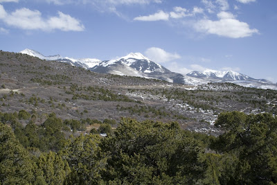
We felt like getting close to the La Sals and so drove up on the La Sal Mountain Loop Road. This is a close-up view of the La Sals, a laccolith intrusion that is about 25 Ma (million years old). The sedimentary veneer that once capped these rocks is since eroded off.


As we drove off of the mountain's north flank, we were treated to a great view of the Castle Valley along the Colorado River.


For me, a visit to this part of the Plateau is incomplete without a stop at the Fisher Towers. The number of movies filmed here are testament to their great beauty but most people don't realize that a phenomenal geologic story is contained in the rocks here as well. It involves ancient mountains that no one ever saw, yet the debris washed out of those mountains remains.....


..... Look at the boulder on the left. Do you see the clasts of schist and gneiss in the sandstone? That is the evidence that a range of mountains, the Ancestral Rockies, once stood east of here about 285 Ma. As the ARM's eroded, material was shed to the west and became incorporated as the Culter Group. When you follow this formation to the east the clasts get bigger, and to the west they get smaller, giving the tell-tale signs of what direction the sediment was being shed.


Ron Blakey's paleogeographic map for the Cutler Group, about 285 Ma. Notice the Ancestral Rockies in southwest Colorado. At the foot of the mountains just inside the Utah state line is where the Fisher Towers are located. Who says there are no time machines?


Just when I begin to feel like there might be too much "red rock fatigue", I turn the van into a small parking lot and we hike up into a watery wonderland called Negro Bill Canyon. You can imagine the older, less sensitive name (some Moab locals have taken political correctness to a new level and refer to this gem of a stream as "African-American William Canyon"). No matter what you call it, the canyon is beautiful and Bill or William had good taste in locating a home. There's nothing like water in the desert.


Two miles up at the head of a side canyon is a source of water coming out of a crack in the sandstone. The water emerges from near the contact of the Navajo Sandstone (the aquifer) and the Kayenta Fm. (the aquaclude or aquatard). Magic!


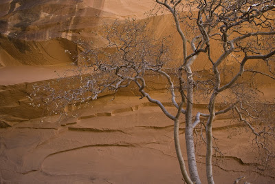
A hackberry tree against the cliff. Is there anything more special that being in places of such beauty?


Morning Glory Arch


The Island in the Sky District of Canyonlands is a place where you can get a sweeping view of everything. Here, Ron Hansen takes in the view.


Looking south towards the Abajo laccolith with the Needles District of Canyonlands in the middle distance. The Needles are part of the Cedar Mesa Sandstone which is the distal extension of the Cutler Group. This part of the region was far enough away from the Ancestral Rocky Mountains that only sand was preserved here. No cobbles of schist or gneiss made it this far out onto the ancient floodplain.


At the Green River Overlook we took in a view of the Turk's Head, a rocky eminence that resembled a turban to some old explorer. The Green River flows nearby. The Turk's head is capped with the White Rim Sandstone.


Looking west, we saw the Orange Cliffs and the Henry Mountain laccolith rising behind them. Why aren't the Orange Cliffs part of Canyonlands National Park?


We did a couple of short hikes around Upheaval Dome, an aptly named oddity in otherwise flat strata. I pulled out three different brochures from the park that reveal the changing interpretations made for this unusual feature. In the 1981 edition, a salt dome interpretation was presented. In a 1993 edition, the salt dome theory competed with an interpretation that this could be a meteorite impact structure. The newest edition of the trail guide lists meteorite impact structure first and salt dome second. An evolving view that highlights the scientific method. That is the beauty of science, it is self correcting and at times can be wrong. But always, science tends towards a more refined truth.


Look at the scalloped heads of these two canyons into the White Rim. There is no indication that the canyons were carved by water running from above. Rather, they seem to be formed from below, meaning that groundwater sapping has undercut the White Rim Sandstone, which causes headward dissection in the upstream direction. The canyons are created from the bottom up and not the top down. Come on a trip with the Museum of Northern Arizona and see for yourself!