Thursday, March 26, 2009

House Mountain Volcano with the Sedona Westerners

On March 25 the wind stopped blowing enough in northern Arizona so that 14 individuals plus myself ventured 3 miles on the Turkey Tank Trail to the top of the House Mountain volcano. This Miocene age (15 to 13 Ma) shield is "Sedona's volcano". I completed my Master's degree by completing a 75 square mile geologic map centered around the vent. It was an awesome project that yielded great rewards. Now, 21 years later, I still lead interested folks up to the crater and we discuss the geologic history along the way. Joan Steninger served as my "sweep" on the hike and provided me with these three pictures from our wonderful day! Thank you for the use of your photos Joan!

Here I am showing off the map that I completed back in 1988. It is vividly colored for a former museum exposition and these are not the normal colors that geologists use to portray rock outcrops. It does however, clearly show the central vent in the center of the map as a heart-shaped orange object. It's actually about a mile across in diameter on the landscape.


Here I am showing the group a stack of agglutinate scoria. What is agglutinate you ask? When House Mountain first erupted, the lave was highly charged with gas and so the lava blobs were thrown into the air as volcanic bombs. When these hit the ground they were still quite hot and they splattered on one another forming agglutinate. I had never noticed this particular outcrop close to where I always have lunch with geology groups and it just shows that even the "experts" are learning all of the time.


Our group is getting ready for lunch on the summit of House Mountain. Notice the red scoria (cinders) on the ground. After my thesis was completed, one of my advisors became so curious about this volcano that he undertook his own studies of the chemistry of the lava's. He discerned that when House Mountain first erupted, it built a cinder cone that was later buried by shield lava's. These outcrops here are from the early cinder cone.


I took a number of new photo's of rock samples on this hike and will use them in the new third edition of Sedona Through Time when it comes out at the end of this year!

Monday, March 23, 2009

Hermit Loop Hike in the Grand Canyon

At the last second, I decided not to bring my camera on this hike. The opportunity to keep my backpack at slightly less than 30 lbs. for a five day hike was just too great of a temptation and that opportunity might not present itself again. I jumped on it and thus, there are no photo's. Who knows, maybe Frank will send me some picture's that he took and I can post them here.

It was an unusual hike in some respects - only one client with two guides. Perhaps a sign of the times but who knows. Andreas from Austria was a great trail partner and the weather was absolutely perfect. 70 or 80 degree days and 50 degree nights. Two nights in Monument Creek allowed us to explore little visited areas in and around The Abyss.

Andreas summed it all up pretty well as he and I sat on the edge of the canyon after finishing the hike. In his slightly toned German accent he casually mentioned, "What a nice little valley you have here." It was a purposely understated comment that we both chuckled at.

Friday, March 13, 2009

First Hike of the Season - The Hermit Trail

Next Monday, March 16 begins the new hiking season for me. It's a 5 day backpack with the Grand Canyon Field Institute. The first day is in the classroom learning all the basics. Then on Tuesday, we'll descend 8 miles down the trail to Hermit Creek. It will be a full day and at the end of it, everyone will believe in gravity. Wednesday will include a 4.5 mile hike over to Monument Creek where we'll lay over on Thursday for some hiking without our backpacks. Friday will be a 10-mile day hiking across the Tonto Platform to Indian Gardens, our last nights camp. And then on Sunday we'll make the 4.5 mile trip to the Grand Canyon Village.

Alas, there is no internet in the canyon ans that is why this preview is being typed now. The season begins!

Tuesday, March 03, 2009

Success on the Three State Book Tour!

My three state book tour is now complete and it was a rousing success. Over 210 people showed up at three different lecture venues to hear the story of the "Ancient Landscapes of the Colorado Plateau". A lot of positive exposure was generated on the trip for this new book. And I met some great people along the way who love to look at landscapes too.

The weather was perfect the whole way. And we will get a lot of use out of that southwestern cookbook we bought at the Back of Beyond bookstore in Moab. Thank you for looking at this blog of our trip. Watch here for other interesting entries in the month of march.

The Drive of Laccoliths

Okay. What is a laccolith? It is a mushroom shaped intrusion now exposed as snowed covered mountains in the area of southwestern Colorado and southeastern Utah. They were formed about 20 to 30 million years ago and as Helen and I made our way from Durango to Moab, we passed some real gems.


The Sleeping Ute Mountain or laccolith, located near Cortez, Colorado. Can you see the sleeping Ute with his headdress and arms folded across his chest?


The Abajo or Blue Mountains laccolith near Monticello, Utah


The La Sal Mountain laccolith near Moab, Utah

Saturday, February 28, 2009

Heading to Moab

Last night we had a fantastic turnout at the monthly meeting of the Four Corner's Geological Society. Nearly 75 people showed up for a magic carpet ride of time travel across the Colorado Plateau. Thanks to the faculty members at Ft. Lewis College in Durango who encouraged their students to attend. It was especially nice to meet so many of them last night.

And thanks also to all who have posted comments on this blog. Today we'll drive northwest through some great scenery on the way to Moab. I'll be posting pictures of it all and then giving a lecture at the Back O' Beyond Bookstore downtown.

Friday, February 27, 2009

Santa Fe to Durango


Wayne and Helen relaxing at the Grand Canyon Association's "New Mexico Headquarters"


After a wonderful stay in Santa Fe, we turned the Subaru north on U.S. Highway 284. We didn’t get too far before we arrived at the “eastern branch” of the Grand Canyon Association in Tesuque. Yep – Ron Short, who designed the “Ancient Landscapes” book (the reason for this book tour), moved here in November and has a wonderful set-up here. He designs Grand Canyon materials remotely from these adobe-lands in New Mexico. Another great wonder in this modern, wired-world we live in.

Exposure of the Santa Fe Group

Leaving Tesuque we drove past the eroded remains of the Santa Fe Group, the “dirt” washed down from the Sangre de Cristo Mountains, filling the Rio Grande Rift. This gravel, sand, and mud deposit is perfect for making great adobe and the homes just seem to rise up naturally right out of the earth here. One unusual rock formation we saw is called Camel Head and I include a painting of it below. We found this painting in a small restaurant in EspaƱola.

Camel Head Rock, painting by Zeye Johnson

Ron Short had told us about this restaurant but mentioned that in the three attempts he had made to eat there, it was always closed. Hmmm? That didn’t sound right since it came to him so highly recommended. We drove towards the center of town and soon saw the hand-painted sign just to the right off the highway: Matilda’s. That’s it.

We turned in the drive and it sure didn’t look open to us. A rumpled children’s swing set was swaying in the breeze. “Looks like its been closed for awhile Wayne”, Helen said disappointingly. I kept driving farther into the compound past dilapidated cars and tired adobe homes. “There it is,” she said. “What do you think?” I took one look and said,”Let’s try it.”


Boy, are we glad we did! It was excellent and the best part about it was that Matilda was there. She is the originator (1956), owner, operator, hostess, and waitress. Her 80+ years haven’t slowed her down a bit. If you ever get to EspaƱola, just hope that it is not a Monday, the only day of the week they are closed. She was so gracious and friendly. I ordered the red beef enchiladas, and Helen had the green with cheese. Check 'em out on the table there!

We still had ¾’s of the drive to do and ½ the day had already passed. I’ll let the pictures do the talking from her on out – it was a great sunny day and the Rockies and Plateau were at their best. Check it out.


The eastern edge of the Colorado Plateau near Abiquiu, New Mexico. These are beds of the Chinle Formation. The Rio Grande Rift has lowered these same rocks tens of thousands of feet just east of here.


Where the Plateau meets the Rockies near Chama, New Mexico. The area has received 132 inches of snow already this winter and the people we spoke to here are glad for the respite of sunshine this week is bringing to the southwest.


Chimney Rock, east of Durango - where deposits of the Mancos Sea (92 million years ago) are arched up in the growth of the Rocky Mountains (70 to 40 million years ago).

Thursday, February 26, 2009

Santa Fe

Yesterday, Helen and I drove out to Santa Fe to begin a little lecture tour for the new book, "Ancient Landscapes of the Colorado Plateau". We were up 2 hours before the sun and left Flagstaff in the dark. We pointed the little Subaru east and began our adventure. We watched the sun rise just west of Holbrook and got to see the Painted Desert in all of its early morning glory. The Chinle Formation sure is pretty in that low angle light.

We entered New Mexico and enjoyed seeing the Wingate Cliffs on our left. Soon, the graceful profile of Mt. Taylor was in view, still layered in a white blanket of snow on its southern slope. Lava flows and the Chinle once again guided us to the eastern edge of the Colorado Plateau.

Once in Santa Fe we met with our host Richard Atkinson of the Public Lands Interpretive Association. Over 75 people showed up for the 2 PM lecture and we sold lots of books. But more important we got folks interested in the long march of geologic time and the wondrous record of earth history that is preserved for us on the modern landscape.

Today we are driving north through fantastic scenes towards Durango. I'll pull out the camera and include some shots from this drive. Just know that we are on a quest to find beauty and the best green chile along the way.

Thursday, February 12, 2009

To Panama and It's Canal

Leaving Iguazu Falls, we flew over the heart of the Amazon Basin. It was mostly cloudy but upon nearing the equator, we caught a view of one of its main branches.

The meanders are incredible, especially when you consider how big these rivers are. The photo was shot from 39,000 feet


Huge ships transit the Panama Canal carrying goods from around the world. The countries with the biggest transport needs here are the U. S., China, Japan, Chile, and Canada. Fees of $200,000 per transit are not uncommon.


Shown here is a section of the Galliard or Culebra Cut, where the Continental Divide has been breached. Note the tilted strata in the cut, raised to this position as the Panamanian Land Bridge was formed about 3 million years ago.


Panama is actively constructing a wider canal, with new locks, to be completed for the 100th anniversary in 2014. Here are some of the machines that are making the Galliard Cut wider.


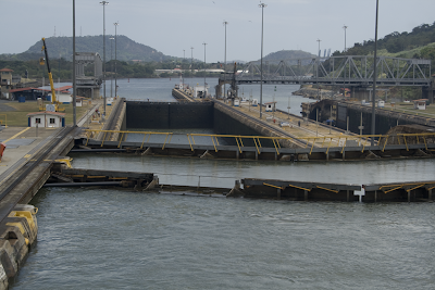
A view of the Pedro Miguel Locks on the Pacific side of the canal. It is an ingenious scheme where water is let down into these locks from a reservoir on the Chagres River. Ships transit the reservoir at 85 feet above sea level.


A view of a "Panamax" ship, one that is just able to fit into the locks. Modern shipping allows for wider ships, thus the canal is being completely redone to accommodate larger ships.


Exiting the canal onto the Pacific Ocean, there is an incredible view of the Panama City skyline. Huge condominiums are being constructed on the coast here. However, a part of old Panama still exists.


The old and the new in Panama


This area was in much decay a few years back but it is being restored to its former glory. There were many similarities to the French Quarter in New Orleans.


A beautiful bouganvillia in Old Panama marks the end of this incredible journey.

Thursday, February 05, 2009

Iguazu Falls - One of the Best

Leaving the cold climate of Patagonia, we landed at hot and humid Iguazu Falls one of Earth's great waterfalls. We visited on the Argentinian side this time. The falls are tremendous to witness and no one leaves unimpressed.


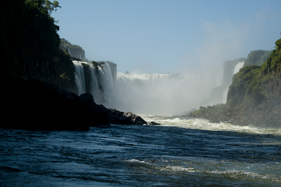
Looking up the channel of the Iguazu River to the Garganta del Diablo - translated as the Throat of the Devil. The spray is voluminous and partially blocks a full full of the falls.


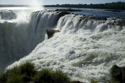
Here is a close-up view of the lip of the falls. The power is immense.


Walks on the Argentinian side of the falls have many of these little cascades. I have visited the Brazilian side many times where most of the water is found.


We took a ride in one of these boats on the river. We had to put the cameras away for that one.


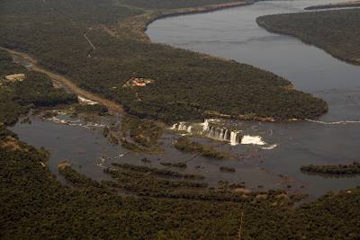
Shown is an aerial view of the falls from our jet with Argentian on the laft and Brazil on the right. Notice how wide the river is above the falls (about a mile) but how it drains into a very narrow channel (only 600 feet) below. The falls are eroding upstream and capturing a quite sluggish river. This happens very slowly at only about 3 feet every 1000 years.

Rounding Cape Horn By Boat

I've been out of e-contact for the last part of this trip because of the lack of online services. After leaving Buenos Aires we flew south to Patagonia and the southern city of Ushuaia, Argentina. Here we boarded the Mare Australus for a cruise in the fjords of the Beagle Channel and chance to see the famous Cape Horn. We were not disappointed in these endeavors.


A look inside of our Explorer jet. There is lots of room but no place to stand and hang out. Everyone sits in a first class seat and there is a chef on board.


Flying in to Ushuaia, we got a great view of the mountains on the island of Tierra del Fuego. It is a fantastic place with usually stormy weather but our luck held and the views were spectacular.


Here is Mt. Olivia to the east of Ushuaia. The rocks here are metamorphic for the most part and formed in the Mesozoic Era (about 120 Ma) as part of the Pacific Ocean subduction complex beneath the western edge of South America.


Here it is - the southern end of South America - Cape Horn. We arrived on a rare cloudless, still day and were able to go ashore. This is a view south towards Antarctica only 600 miles away. The sea doesn't look like a washing machine on days like these.


The lighthouse at Cape Horn, manned by members of the Chilean Navy


Here is a monument to all of the sailors lost at sea while rounding the Horn. The number who lost their lives is estimated at 10,000 souls. Can you see what is represented in the monument?


Self portrait from Cape Horn monument. The answer to the question above - it's an albatross, symbol of those who lost their lives here.


After leaving the cape we sailed north to Wulaia Bay, visited by Charles Darwin in 1834. This was a rich gathering place for Yamana Indians, the worlds southernmost people. We hiked into a beech forest when I snapped this shot towards the bay.


The Yamana are totally extinct now, savaged by disease and a program of extermination in the late 1800's. Fortunately, photographs survive of these amazing people, who lived in a very cold place without the use of much clothing. This image is one I used in my lecture about Patagonia.


Looking towards an oncoming storm. This was one of the rare times we received rain on this trip.


Here's the Pia Glacier as it spills out from the Darwin Range on the island of Tierra del Fuego. It has receded a great deal in the last 30 years.


More Pia Glacier


Just 30 years ago, this rock was buried in ice. The glacial striations that were etched into it are evident and it was features like these that gave geologists the evidence for prior Ice Ages.


The rocks beneath the ice show evidence for massive amounts of compression in the creation of the Patagonian landscape. This cliff face, almost 1,000 feet high, shows how the rocks were bent almost 180 degrees.


Folding of the rocks (at depth where they are ductile and not brittle) is evident on many scales. This basalt intrusion was variably folded (see sandal for scale).

Wednesday, January 28, 2009

Buenos Aires, Argentina

One of my favorite cities, I think this stop has been the best so far for me. Since I was here just one year ago and we did basically the same things then, I will refer you to that post dated January 15 to 18, 2008. There you will find pictures of this fantastic hotel, the gauchos and city scenes. Check it out. Here are few more pictures from this trip of the Recoleta Cemetery. The recent plane crash in Flagstaff where two popular river guides were killed causes all of us to wonder about life and death. Here in Buenos Aires, the mystery of death to us humans is evident.

Central Buenos Aires and the Rio de La Plata from 10,000 feet.


One of the many alley ways in Recoleta Cemetery, where Buenos Aires elite have been buried since the mid-1800's. Families pay rent to keep there ancestors remains here and sometimes people will even rent space for a casket for only 4 days just to say that their relatives had a funeral in Recoleta.


Many of the mausoleums are ornate with marble and other stone. Many of these mausoleums have 3 or four stories beneath the ground to accommodate the remains of the many generations inside.


One could look for hours at these plaques and find them interesting. I was taken by this one that told a story of one D. Antonio F. Celesia. He was obviously well-liked by many as reads his plaque: "To Professor D. Antonio F. Celesia - From your college disciples and friends".


And a representation of him at work in his chosen profession - a doctor of physiology who taught his students how to know the human body.


This is the mausoleum of the Duarte family and their most famous daughter, Eva Peron.


Eva Peron's plaque.


Look at the detail in this marble statue of a woman holding the door to the family mausoleum. As individual mortals, we forever try to keep the flame of life alive, baffled by those rare but important days when our loved ones do not awaken forever more. By giving scenes of life like this to burial grounds, we try to eases the pain by invoking ideas that something must lie beyond the darkness. Yet common sense and connecting the dots reveals that we are given only so much time - and then are away, making room for other lives. In this way, we perhaps never die. We must make our lives meaningful while alive in the here and now and not concern ourselves with morbid thoughts of our mortality.


For us, the living, life goes on. We go about the business of our lives are try not to think that one day we too will be called to inhabit the cemeteries of the dead. It is as it should be and we cannot change it. Peace and love to Tom and Frank, taken too soon from us. We are reminded of the good you left us. On to Patagonia for now. Love.