On Saturday, November 12, I led a group of 27 avocational archaeologists from the Desert Foothills Chapter of the Arizona Archaeological Society on a geology field trip to the Spur Cross Ranch Conservation Area. The park is one of the gems in the Maricopa County Regional Park System and was established in 2001 to encompass 2,154 splendid acres of the northern Sonoran Desert. Many "arch" sites are located within the preserve and the members of the club wanted to learn more about the geological resources here. I had previously given two geology lectures to the group, in my role as an Arizona Road Scholar. This program is a part of the Arizona Humanities Council, whose mission is "to build a just and civil society by creating opportunities to explore our shared human experiences through discussion, learning and reflection". The AHC is one of the best programs I know of in the state of Arizona.
The history of the preservation effort of the Spur Cross Ranch is an interesting one but much too convoluted to go into detail here. In short, developers bought an old cattle ranch in the 1990's with the intent of creating a mini-city on the north fringes of Phoenix. This was during the boom-boom days of the Arizona housing frenzy and it looked like a done deal. Not so fast, said the citizens of Cave Creek, a sleepy little hamlet that started life as a mining camp in the 1870's. They voted for a sales tax that paid for the land sparing it from development. With 80% of the town voting in the election, 77% of them voted in favor of the 0.5%, 20-year sales tax. The cost of the bond will be paid off by next June (eight years early) and a story can be read here that details the history of the acquisition fight. For a more jaded view of the preservation effort, you can read it here.
After I gave a brief overview of the geology at the trailhead, we hiked up Cottonwood Wash. The geology begins with its location in the north part of the Phoenix basin, specifically at the junction of Arizona's Transition Zone and the Basin and Range. Many mine shafts are located here and recall the glory days of prospecting when Arizona was seemingly as far away as Mongolia. Miners were lucky in some instances in finding gold and silver in the area. These elements would have held no value to ancestral peoples.
My gracious hostess, Paddi Mazoli, at the entrance to the Nutcracker Mine in the Spur Cross area. Two groups of rocks are found here - an older sequence of Precambrian meta-sediments and meta-volcanics, and much younger basalt lava flows and sediments that are Cenozoic in age. Paleozoic and Mesozoic sedimentary rocks were likely here at one time but have been removed by erosion.
**2019 Update** - Thomas McGuire, who is writing a book about the Spur Cross Ranch geology, sent me a recent photo of the Nutcracker Mine entrance. A few years ago, a rockfall closed off the entrance. I attach his photo of the mine entrance before (2009 photo) and after ("a few years ago).
In the washes of the area, most of the durable rock types can be found. These make for a colorful mélange that are striking in their appearance. By far though, the most striking outcrops involve the lava flows of the Hickey Formation that cap Skull Mesa (shown here) and New River Mesa to the west. These flows were emplaced about 14.8 million years ago when the valley floor was not as dissected.
Skull Mesa located northeast of the Spur Cross Ranch Conservation Area is capped by Hickey basalt that has been dated at 14.8 Ma. The whitish outcrops beneath the mesa top belong to the Chalk Canyon Formation, a lacustrine and fluvial deposit that had yielded Arizona's oldest mammal fossil, an oreodont.
Artists reconstruction of an oredont, an example of which was found in the Chalk Canyon Formation near Cave Creek, Arizona, when this area held an ancient lake some 22 Ma
The Hickey basalt lava flows once continued much farther to the south after they were erupted, but more recent faulting disrupted the flow ends. This is evident everywhere in the northern parts of the Phoenix basin. Here from near the center of Cave Creek Town, you can see the same flows that were once attached to Skull Mesa. They have been faulted such that the former tops of the lava flows are now slopes on the right side (north end) of the hills. As the Phoenix basin was extended, the flows slipped downward and became tilted. Geology in action!
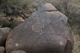
Petroglyphs abound in the area as do these boulders of Hickey basalt
Note this basalt boulder which has been rolled in a flood once or twice in Cave Creek! The white calcium ring that was once sitting horizontally in a pool of water has been moved such that it is now vertical on the rock. A new calcium ring has begun to form at the base in its present position.
It is a lovely area and a big thanks to the members of the Desert Foothills Chapter of AAS. They were most welcoming and a great group to hike with. Also, a big thank you to the citizens of Cave Creek who temporarily taxed themselves so that these 2,154 acres would be preserved in perpetuity for all Arizonans. Your forward thinking is very much appreciated by this Flagstaff boy.
Rainbow over Cave Creek, November 12, 2011


No comments:
Post a Comment
If your comment will not post, email me with the problem.